

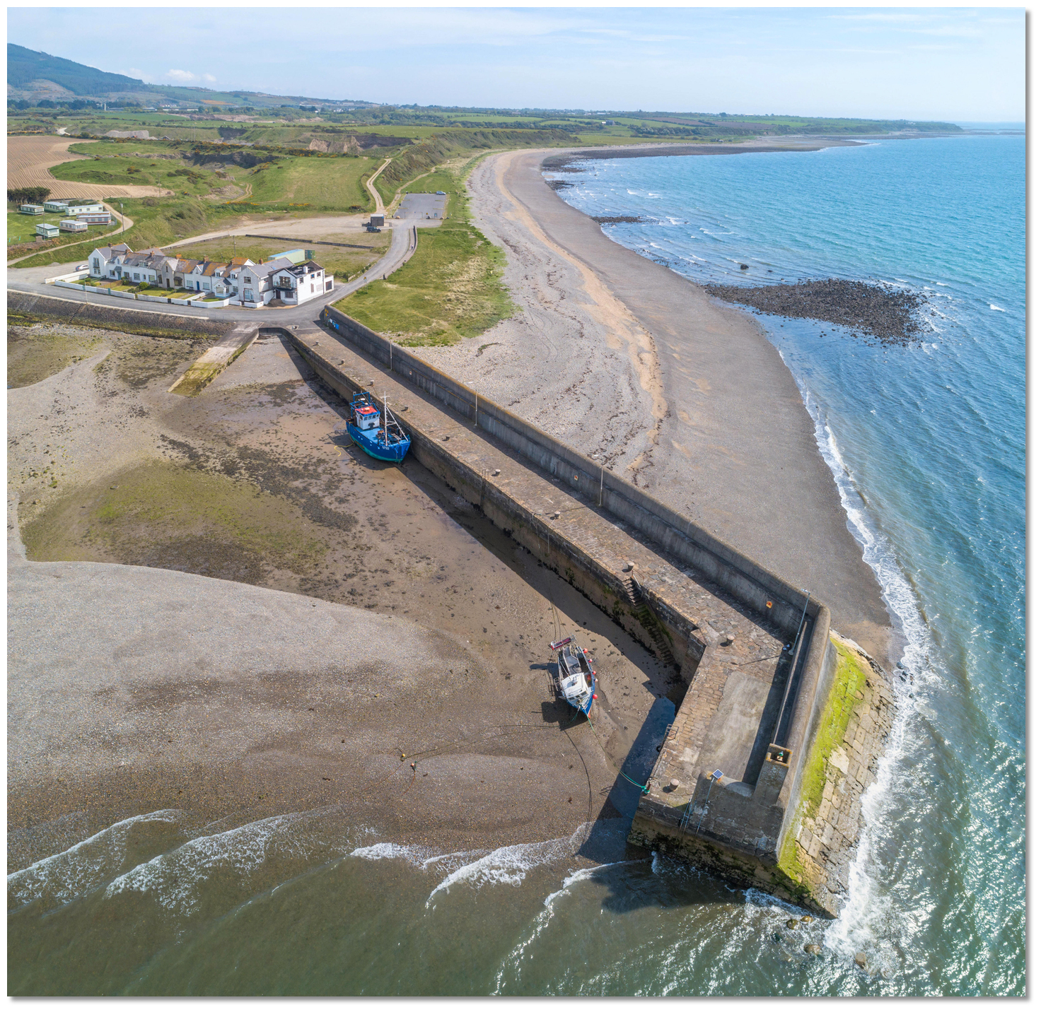
Giles, or Gyles’, Quay is situated on the northeast coast of Ireland, on Dundalk Bay’s northern shore and at the foot of the Carlingford Mountains. It is an isolated and drying quay that offers the only viable anchoring location in the extensive but shallow Dundalk Bay.
This is a good anchorage in wind conditions from west round to northeast with very good sand holding. A vessel will find completely flat water anything up to a mile offshore in these conditions. However, with winds from any other quadrant, the anchorage is completely exposed. Access is straightforward as there are no unmarked off-lying dangers and the quay is completely open to a seaward approach.


Keyfacts for Giles Quay


Summary* Restrictions apply
A good location with safe access.


Nature


Considerations

Position and approaches

Haven position
 53° 59.064' N, 006° 14.394' W
This is the head of the pier where a light stands Fl G 3s.
What is the initial fix?
 53° 58.566' N, 006° 14.440' W


What are the key points of the approach?
 .
.- The area to the south of the pier is deep, gradually rising and has no outlying dangers. It may be freely approached from south round to east.
Not what you need?
- Carlingford Harbour - 4.1 nautical miles NNE
- Carlingford Marina - 4.4 nautical miles NNE
- Greer’s Quay - 5.3 nautical miles N
- Dundalk - 5.5 nautical miles WNW
- Killowen - 5.8 nautical miles NNE
- Greencastle - 5.8 nautical miles NE
- Rostrevor - 6 nautical miles NNE
- Omeath - 6.4 nautical miles N
- Warrenpoint - 6.7 nautical miles N
- Kilkeel Harbour - 9.8 nautical miles ENE
- Carlingford Harbour - 4.1 miles NNE
- Carlingford Marina - 4.4 miles NNE
- Greer’s Quay - 5.3 miles N
- Dundalk - 5.5 miles WNW
- Killowen - 5.8 miles NNE
- Greencastle - 5.8 miles NE
- Rostrevor - 6 miles NNE
- Omeath - 6.4 miles N
- Warrenpoint - 6.7 miles N
- Kilkeel Harbour - 9.8 miles ENE


What's the story here?
 Giles Quay
Image: Michael Harpur
Giles Quay is situated on the northern shore Dundalk Bay and the southern shores of the Cooley peninsula 3½ miles within Cooley Point. It consists of an isolated stone pier extending 120 metres southward with a small scattered hamlet immediately inshore.
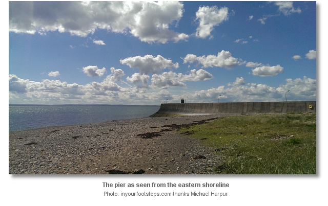
The pier dries beyond its head at low water so vessels planning to stay afloat should anchor off according to draft. Depths of 2 metres are available close to the pierhead with excellent sand holding. This is the last place to lie afloat in the protection that Dundalk Bay offers as from Giles quay extensive sandbanks sweeps round the bight of the bay to beyond Anagassan, on the south shore, uncovering at low water for a distance of up to 2 miles from the high-water limit.
 Giles Quay at low water
Image: Michael Harpur
Vessels that can take-to-the-hard can come alongside any part of the pier and dry out over a sand bottom.
How to get in?
 Giles Quay with Cooley Point in the backdrop
Image: Michael Harpur
 Seaward approaches are detailed in eastern Ireland’s coastal overview for Strangford Lough to Dublin Bay .
 Dundalk Pile Lighthouse - Fl WR 15s 10m 21M position: 53° 58.560’N, 006° 17.714’W
 Dundalk Pile Light
Image: Mark Murray via CC BY-SA 2.0
Dunany Light buoy - (port hand) Fl R 3s position: 53° 53.530’N, 006° 09.502’W
Imogene Light buoy - (port hand) Fl (2) R 10s position: 53° 57.415’N, 006° 07.042’W
Dunany Point has a drying rock lies about ½ a mile east by northeast of the point. Dunany Shoals, with a least depth of 1.8 metres, lies north of the point. These are marked by a lighted buoy moored about 3½ miles northeast of the point.
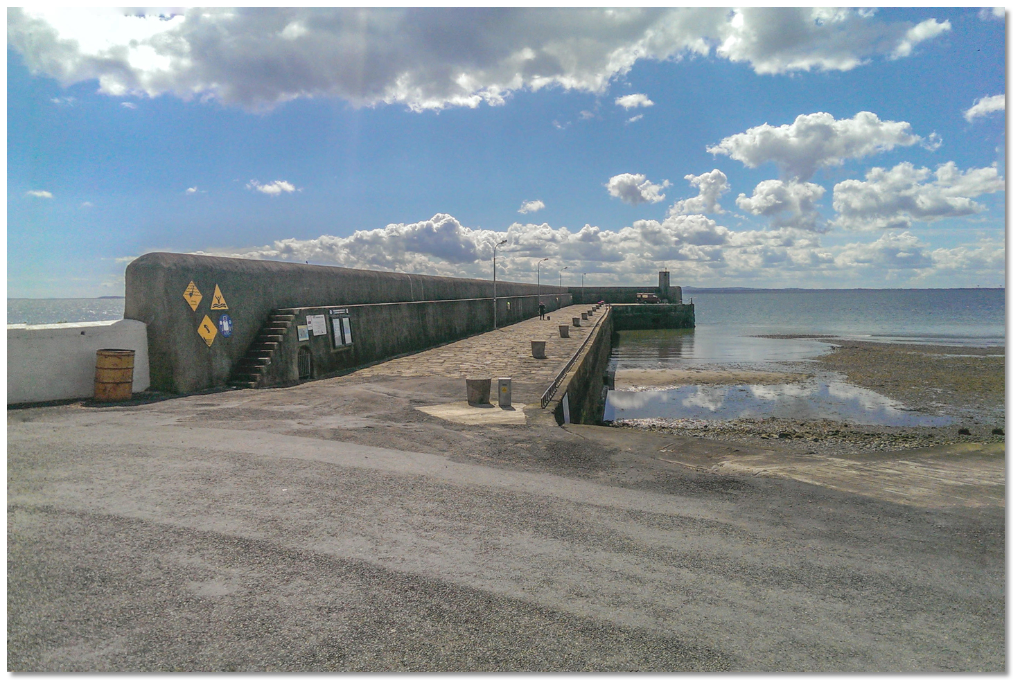
By night a pierhead light Fl G.3s stands on an extending spur at the outer end of Giles Quay. But vessels are best advised to stand well off for fear of running into lobster pots off the pier.
 The Gyles’ Quay initial fix is set 2 miles east of the Dundalk Pile Lighthouse. A bearing of due north for 1 mile will take a vessel directly to the stone pier from the initial fix.
 The pier should be highly visible from the initial fix and will most likely have a lobster boat nearby as at least one commercial potting vessel is based here. As such approaching vessels should keep a sharp lookout as the entrance of the harbour and or access to the quay will be barred from some directions by lines of floating fish pots.
 Giles Quay with its inner slipway
Image: Michael Harpur
The pier dries beyond its head at low water so vessels planning to stay afloat should anchor off according to draft. Depths of 2 metres are available in an area that ranges from 200 metres south of the pier head stretching across 200 metres west of the pierhead. Any further west and the depths drop off to 1 metre and then less. Excellent sand holding will be found throughout this area. Land at the slip. Those intending to come alongside temporarily will find the deepest water alongside the pierhead’s 17-metre spur. Expect to find 2 metres here at half-tide and a convenient ladder to come ashore.
Why visit here?
Giles Quay, also 'Gyles's' or 'Giles' Quay, derives its name from Ross Gyles who built a wooden pier here in 1780. The original wooden structure eroded away in time and was rebuilt in stone in 1824. Old stone bollar of Giles Quay with the Carlingford Mountains in the backdrop
Image: Michael Harpur
This pier served as a local quay for fishermen, and the 19th-Century boarding point for Dundalk port's pilots. During this period the location also became convenient for the illegal importation of wine and tobacco. The pier's easy seaward access with a long and isolated strand combined with an accessible hinterland made it ideal for smugglers to land their trade on the beach. It was to stem this illegal importation that the coastguard watch station was constructed in 1823 when the new pier was under construction. Alongside this, a small quaint village grew around the pier. It includes a scattering of three rural churches and some buildings that include an interesting early classical house.
 The pretty stone work of Giles Quay
Image: Michael Harpur
Today Giles Quay is very popular with holidaymakers that stay at the caravan park situated on the cliff above the quay. The area's attractiveness is readily apparent. The extensive stone pier, with its original stone paving, granite bollards and former coastguard houses at the base, is very pretty. Then add to it the vast stretches of isolated sand-gravel beaches that it protects and you have the perfect sand and bucket day out. When the backdrop of the Cooley Peninsula, with the Carlingford Mountains, are included you have all the ingredients that makeup one of the most picturesque regions in Leinster.
From a boating point of view, Gyles' Quay is a beautiful location to drop anchor in northerly quadrant winds and the best anchoring location in Dundalk Bay.
What facilities are available?
Gyles’ Quay has very little other than the pier with a slipway. At the top of the hill above the pier there is a shop, takeaway and pub with basic provisions servicing a small caravan park in the season. The pier is located 1 km south of the R173/R175 road that is the main Dundalk-Carlingford road about 11km from Dundalk.Any security concerns?
Never an issue known to have occurred anchored off Gyles’ Quay.With thanks to:
Charles Floody, Drogheda Harbour Pilot for more than three decades, and Brian Lennon.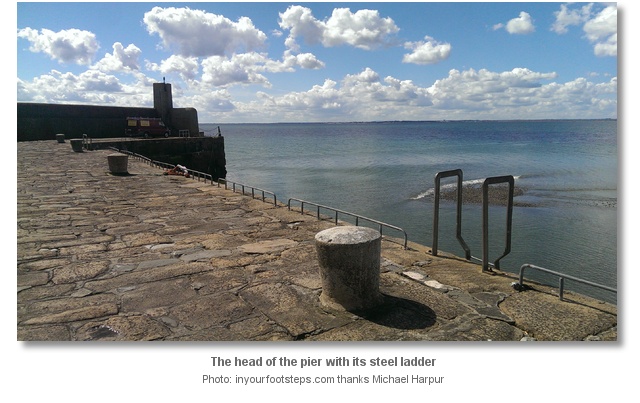


Aerial views of Giles Quay
About Giles Quay
Giles Quay, also 'Gyles's' or 'Giles' Quay, derives its name from Ross Gyles who built a wooden pier here in 1780. The original wooden structure eroded away in time and was rebuilt in stone in 1824.
Old stone bollar of Giles Quay with the Carlingford Mountains in the backdropImage: Michael Harpur
This pier served as a local quay for fishermen, and the 19th-Century boarding point for Dundalk port's pilots. During this period the location also became convenient for the illegal importation of wine and tobacco. The pier's easy seaward access with a long and isolated strand combined with an accessible hinterland made it ideal for smugglers to land their trade on the beach. It was to stem this illegal importation that the coastguard watch station was constructed in 1823 when the new pier was under construction. Alongside this, a small quaint village grew around the pier. It includes a scattering of three rural churches and some buildings that include an interesting early classical house.
The pretty stone work of Giles QuayImage: Michael Harpur
Today Giles Quay is very popular with holidaymakers that stay at the caravan park situated on the cliff above the quay. The area's attractiveness is readily apparent. The extensive stone pier, with its original stone paving, granite bollards and former coastguard houses at the base, is very pretty. Then add to it the vast stretches of isolated sand-gravel beaches that it protects and you have the perfect sand and bucket day out. When the backdrop of the Cooley Peninsula, with the Carlingford Mountains, are included you have all the ingredients that makeup one of the most picturesque regions in Leinster.
From a boating point of view, Gyles' Quay is a beautiful location to drop anchor in northerly quadrant winds and the best anchoring location in Dundalk Bay.
Other options in this area
Port Oriel (Clogher Head) - 6.9 miles S
Drogheda & The River Boyne - 10.2 miles SSW
Balbriggan Harbour - 13.9 miles S
Skerries Bay and Harbour - 15.1 miles SSE
Carlingford Marina - 2.7 miles NNE
Greer’s Quay - 3.3 miles N
Omeath - 4 miles N
Newry - 7.2 miles NNW
Navigational pictures
These additional images feature in the 'How to get in' section of our detailed view for Giles Quay.


| Detail view | Off |
| Picture view | On |
Aerial views of Giles Quay
Add your review or comment:
Rodolphe Thimonier wrote this review on Jun 25th 2016:
Good holding. Beware, the entrance of the harbour/access to the quay can be barred by lines of floating fish pots. Being exposed to the swell of the bay, the anchorage is uncomfortable as soon as the wind is weaker than the swell.
Average Rating:

Michael Harpur wrote this review on May 22nd 2018:
Thankyou Rodolphe,
Updated the main body of the text with your additional information.
Please log in to leave a review of this haven.
Please note eOceanic makes no guarantee of the validity of this information, we have not visited this haven and do not have first-hand experience to qualify the data. Although the contributors are vetted by peer review as practised authorities, they are in no way, whatsoever, responsible for the accuracy of their contributions. It is essential that you thoroughly check the accuracy and suitability for your vessel of any waypoints offered in any context plus the precision of your GPS. Any data provided on this page is entirely used at your own risk and you must read our legal page if you view data on this site. Free to use sea charts courtesy of Navionics.