

Portachurry is a narrow rocky inlet situated on the south west corner of Inishtrahull Island that lies approximately six miles east of Ireland's northmost point Malin Head. In very settled conditions a temporary respite anchorage could be had here in the mouth of the inlet or a small boat could come alongside a small jetty at the head of the inlet.
Portachurry is a stay-aboard anchorage that only affords tenacious protection from northerly winds. It is however severely exposed to Atlantic swell and holding can be poor off the rocky inlet. Access requires careful navigation and good visibility as the surrounding inlet is fringed with rocks and the area is subject to strong currents, standing waves and tidal races.


Keyfacts for Portachurry


Last modified
July 10th 2021 Summary* Restrictions apply
A stay-aboard location with careful navigation required for access.Facilities

Nature


Considerations


Position and approaches

Expand to new tab or fullscreen
Haven position
 55° 25.716' N, 007° 14.575' W
This is the approximate anchoring location off the mouth of the inlet on the southwest corner of the island.
What is the initial fix?
The following Portachurry Initial Fix will set up a final approach:
 55° 25.600' N, 007° 14.786' W


What are the key points of the approach?
Offshore details are available in the northeast Ireland’s Coastal Overview for Malin Head to Strangford Lough  .
.
.- Vessels approaching from the east will find open water all the way to Inishtrahull and Portmore.
- Vessels approaching from the west should avoid the Garvan Isles and will find it easier to round Inishtrahull's southern side.
- Align a bearing of 227° T of the conspicuous red tripod crane situated on the Portmore quay and track into the cut.
- Pass between the flanking outer rocks and continue up the centre of the cut.
Not what you need?
Click the 'Next' and 'Previous' buttons to progress through neighbouring havens in a coastal 'clockwise' or 'anti-clockwise' sequence. Below are the ten nearest havens to Portachurry for your convenience.
Ten nearest havens by straight line charted distance and bearing:
- Portmore - 0.5 nautical miles NE
- Malin Harbour or Slievebane Bay - 4.6 nautical miles SW
- Culdaff Bay - 8.3 nautical miles SSE
- Tremone Bay - 11 nautical miles SSE
- Kinnagoe Bay - 13 nautical miles SE
- Lenan Bay - 14.9 nautical miles SW
- Portkill - 15.6 nautical miles SE
- Portnocker - 16.1 nautical miles SE
- Moville - 16.1 nautical miles SSE
- Carrickarory Pier - 16.2 nautical miles SSE
These havens are ordered by straight line charted distance and bearing, and can be reordered by compass direction or coastal sequence:
- Portmore - 0.5 miles NE
- Malin Harbour or Slievebane Bay - 4.6 miles SW
- Culdaff Bay - 8.3 miles SSE
- Tremone Bay - 11 miles SSE
- Kinnagoe Bay - 13 miles SE
- Lenan Bay - 14.9 miles SW
- Portkill - 15.6 miles SE
- Portnocker - 16.1 miles SE
- Moville - 16.1 miles SSE
- Carrickarory Pier - 16.2 miles SSE


What's the story here?

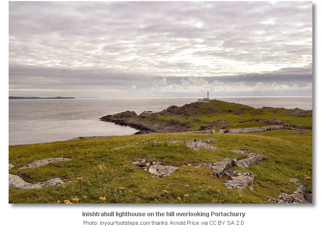
Inishtrahull is situated off the north coast of Ireland three miles northwest of the outermost Garvan Isle across Inishtrahull Sound. It is nearly a mile long and is made up of two rounded hills joined by a stretch of low ground with a prominent lighthouse at its western end. Portachurry is a narrow rocky inlet situated on the south west corner of Inishtrahull Island under the lighthouse.
How to get in?
 Approaches to the island are detailed in the islands primary berth of Portmore
  .
.  The Portachurry initial fix is 400 metres southwest of the bay and 600 metres south-southwest of Inishtrahull lighthouse on the summit of the hill that makes up the western side of the island. A bearing of 45° T from the initial fix will lead into the anchoring location. The southern shore of Inishtrahull is steep to, free of off lying dangers and can be approached as close as 100 metres.
 The final few metres require keen eyeball navigation and close observation to stay clear of drying rocks fringing the shore whilst finding an anchoring location.
 Anchor in 10 or 11 metres in the mouth of the inlet. The narrow southwest facing inlet leads to a jetty with 1.5 metres, and a slip and steps. Landing here is not recommended as it will most likely be exposed to Atlantic swell.
Why visit here?
Portachurry in Gaelic means ‘Currach Harbour’ which aptly describes the rocky inlet. The gut has provided a dramatically less attractive but nonetheless alternative landing place for islanders over the centuries. The southwest facing inlet has a jetty, steps and a slip, but landing here is said to be a problem. It is exposed to the Atlantic swell and as such it is not recommended.A better anchorage, along with details on Inishtrahull Island, can be found in the island’s primary berth of Portmore
. However in very settled conditions or light northerlies, in the absence of swell, Portachurry could provide an option to drop off a shore party or a temporary small boat berth. Likewise the anchorage in the mouth of the bay could prove convenient for crews looking for respite from northerlies, a lunch stop or tide wait location when Portmore may not be used. What facilities are available?
There are no facilities on Inishtrahull and landing is not recommended at Portachurry as the location is subject to swell.Any security concerns?
This is a stay-aboard anchorage where it would be unsafe to leave a vessel unattended. This aside, never an issue is known to have occurred to a vessel anchored in this isolated location of the uninhabited Inishtrahull.With thanks to:
Bill McCann, Londonderry Harbour Master. Photography with thanks to Margaretincarn and Arnold Price.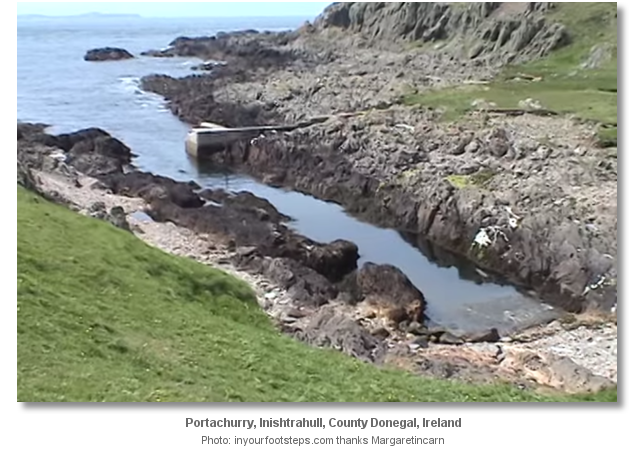
This video presents a Sea Kayaking visit to Inishtrahull's south-western corner.
About Portachurry
Portachurry in Gaelic means ‘Currach Harbour’ which aptly describes the rocky inlet. The gut has provided a dramatically less attractive but nonetheless alternative landing place for islanders over the centuries. The southwest facing inlet has a jetty, steps and a slip, but landing here is said to be a problem. It is exposed to the Atlantic swell and as such it is not recommended.
A better anchorage, along with details on Inishtrahull Island, can be found in the island’s primary berth of Portmore
. However in very settled conditions or light northerlies, in the absence of swell, Portachurry could provide an option to drop off a shore party or a temporary small boat berth. Likewise the anchorage in the mouth of the bay could prove convenient for crews looking for respite from northerlies, a lunch stop or tide wait location when Portmore may not be used. Other options in this area
Click the 'Next' and 'Previous' buttons to progress through neighbouring havens in a coastal 'clockwise' or 'anti-clockwise' sequence. Alternatively here are the ten nearest havens available in picture view:
Coastal clockwise:
Portmore - 0.3 miles NECuldaff Bay - 5.2 miles SSE
Tremone Bay - 6.8 miles SSE
Kinnagoe Bay - 8 miles SE
Portkill - 9.6 miles SE
Coastal anti-clockwise:
Malin Harbour or Slievebane Bay - 2.9 miles SWLenan Bay - 9.2 miles SW
Crummie's Bay - 10.6 miles SW
Dunree Bay - 10.8 miles SW
Buncrana - 12.2 miles SSW
Navigational pictures
These additional images feature in the 'How to get in' section of our detailed view for Portachurry.


| Detail view | Off |
| Picture view | On |
This video presents a Sea Kayaking visit to Inishtrahull's south-western corner.
Add your review or comment:
Please log in to leave a review of this haven.
Please note eOceanic makes no guarantee of the validity of this information, we have not visited this haven and do not have first-hand experience to qualify the data. Although the contributors are vetted by peer review as practised authorities, they are in no way, whatsoever, responsible for the accuracy of their contributions. It is essential that you thoroughly check the accuracy and suitability for your vessel of any waypoints offered in any context plus the precision of your GPS. Any data provided on this page is entirely used at your own risk and you must read our legal page if you view data on this site. Free to use sea charts courtesy of Navionics.