

Mill Bay offers good shelter within the enclosed waterway of Larne Lough. However, being located in the southeast corner of the lough, it is somewhat exposed to a fetch that can develop across the large expanse of water to the northwest. Access is straightforward as Larne Lough may be approached day or night, at any stage of the tide and in all reasonable conditions. Outside of the harbour area, navigation aids become scarce but the trek down to the anchorage is via a deep channel off the shore with no obstructions.

Keyfacts for Mill Bay
Facilities


Nature


Considerations


Protected sectors

Approaches

Shelter

Last modified
December 15th 2022 Summary* Restrictions apply
A good location with attentive navigation required for access.Facilities
Nature
Considerations
Position and approaches

Expand to new tab or fullscreen
Haven position
 54° 49.380' N, 005° 45.488' W
This is in 1.7 metres of water about 400 metres west by southwest of the pier.
What is the initial fix?
The following Larne Harbour Initial Fix will set up a final approach:
 54° 51.580' N, 005° 47.550' W


What are the key points of the approach?
Offshore details are available in the northeast Ireland’s Coastal Overview for Malin Head to Strangford Lough  .
.
.- Approach directions to the Lough are available in Larne Harbour
 .
. - Track down along the deep water channel that follows the western side of Islandmagee’s shoreline to Mill Bay.
Not what you need?
Click the 'Next' and 'Previous' buttons to progress through neighbouring havens in a coastal 'clockwise' or 'anti-clockwise' sequence. Below are the ten nearest havens to Mill Bay for your convenience.
Ten nearest havens by straight line charted distance and bearing:
- Ballydowan - 0.4 nautical miles NNW
- Magheramorne Point - 0.5 nautical miles WSW
- Larne Harbour - 1.3 nautical miles NW
- Portmuck - 1.8 nautical miles NE
- Brown’s Bay - 2 nautical miles NNW
- Ferris Bay - 2 nautical miles NNW
- Whitehead - 4.7 nautical miles SSE
- Ballygalley Bay - 5.8 nautical miles NW
- Carrickfergus Harbour & Marina - 7 nautical miles SSW
- Greenisland - 8.5 nautical miles SSW
These havens are ordered by straight line charted distance and bearing, and can be reordered by compass direction or coastal sequence:
- Ballydowan - 0.4 miles NNW
- Magheramorne Point - 0.5 miles WSW
- Larne Harbour - 1.3 miles NW
- Portmuck - 1.8 miles NE
- Brown’s Bay - 2 miles NNW
- Ferris Bay - 2 miles NNW
- Whitehead - 4.7 miles SSE
- Ballygalley Bay - 5.8 miles NW
- Carrickfergus Harbour & Marina - 7 miles SSW
- Greenisland - 8.5 miles SSW

Chart

What's the story here?
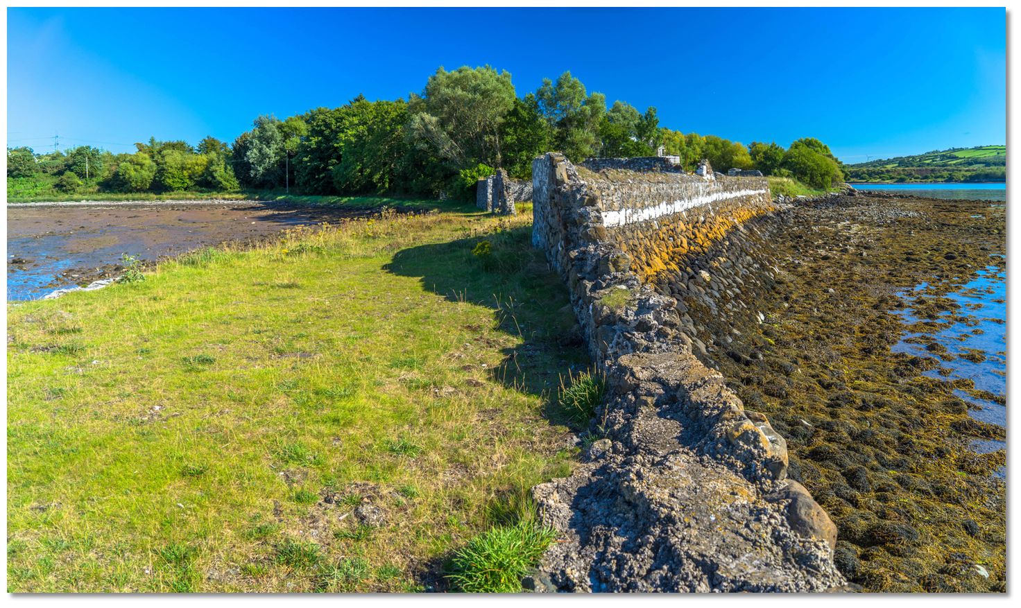
 Mill Bay with its old quay on its southern projection
Image: Michael Harpur
Mill Bay, also historically known as Carnspindle Bay, is a small drying bay inside Lough Larne, on the western shore of Islandmagee and about 2 miles to the southeast of Larne Harbour. The bay is formed by a projection of the coast immediately to the south that has a derelict old stone pier at its head. In the immediate area above is a cluster of about 40 houses that are home to about a hundred people.
 The view from the head of the old stone pier
Image: Michael Harpur
The nook in the Lough Larne offers a quiet anchorage with good holding, very little tidal flow and convenient landings off the old pier which dries or a nearby slip.
How to get in?
 The run from Larne Harbour to Mill Bay
Image: Michael Harpur
 Use the directions for Larne Harbour for approaches and entry to Lough Larne. After entering the harbour continue south past Ballylumford Power Station and its pier, between the L-shaped 'A' wharf and No.7 buoy, and then along the western shore of Islandmagee.
  The shoreline of Islandmagee has deep water beyond Ballydowan
Image: Michael Harpur
Here the eastern shore of the inner Lough is covered by a gravelly foreshore that dries up to 200 metres off. Outside of this there is a 200-metre wide channel that carries at least 6 metres of water for a ½ mile. Close after the Larne Lough's yellow buoy is passed to starboard it falls to 4 metres and then to about 2 metres abreast of Ballydowan where local boats will be seen moored.
Larne Lough - Buoy Yellow Fl.Y.5s position: 54° 49.901' N, 005° 46.481' W
Mill Bay is situated a ½ mile further along and 1.5 metres will be found all the way in the channel although it shallows in the final approaches to the bay.
 Anchor off to the southwest of the pier
Image: Michael Harpur
Boats drawing up to 2 metres should keep at least 300 metres away from the pier. Boats drawing 1.5 metres or less may come in as close as about 100 metres off the end of the pier. There is good holding in both locations and very little tidal flow. Boats that can take to the bottom may be able to dry alongside the old pier but inspect the bottom first. The old pier dries at low water beyond its head
Image: Michael Harpur
A landing can be made at a slip on the north side of the bay or at the pier itself. The old pier dries out beyond the head at low water springs.
Why visit here?
Mill Bay is a small pier with a cluster of houses overlooking Larne Lough. It is often called Carnspindle Bay, as it lies within the townland of Carnspindle. Mill Bay is a quiet out of the way rural retreat
Image: Michael Harpur
Carnspindle derives its name from Irish 'Carn Spinnil', meaning 'cairn (marker) of the sandbank'. The ruin of the old stone pier and its associated buildings date back to 1839. It was erected to support local fishing craft but it was also used by a ferry and traders docked and unloaded coal on the quay.
 The old the old stone pier and associated buildings were erected in 1839
Image: Michael Harpur
Today Mill Bay is a quiet backwater that offers the boater a secluded anchorage hidden away behind the gentle gradients of Islandmagee’s western shore deep within the lower Lough’s sheltered waters. It is a place to get away from the hurly-burly associated with the busy harbour.
 The old piers of the gated yard belonging to pier
Image: Michael Harpur
On a sunny day, the old pier or the enclosure formed by its old walls makes for the perfect place to have a picnic. Reportedly, there is a mussel and oyster farm located in the vicinity where it is said its produce may be purchased directly from the owner including crab and lobster.
 The enclosure formed by the old walls of Mill Bay's pier
Image: Michael Harpur
There is also the option of the local cosy friendly family-run country-style pub a short walk away. This offers an extensive bar snack menu featuring local produce.
What facilities are available?
There is a slip and a pier but little else. A friendly pub serves the small population that surrounds the harbour in a cluster of about 50 houses with a population of less that 100 people, but there are no shops. The small village of Mullaghboy one mile away, has basic provisions to serve its population of about 300 people, and a café that also serves good food. Almost everything else is available in nearby Larne harbour.Any security concerns?
Never a problem known to have occurred in Mill Bay.With thanks to:
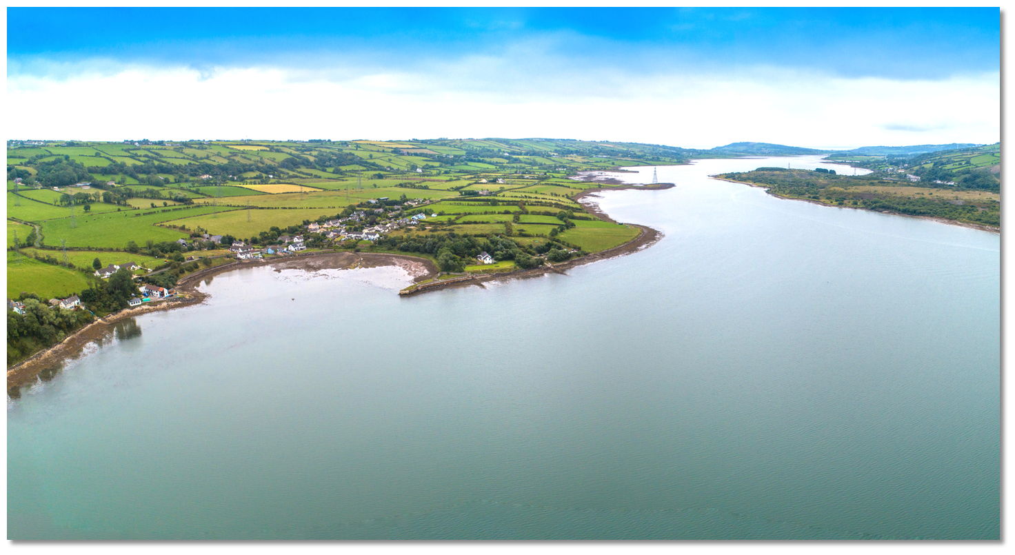
Terence Stitt, Portmuck Harbour Master.Magheramourne to Millbay aerial view


Add your review or comment:
Please log in to leave a review of this haven.
Please note eOceanic makes no guarantee of the validity of this information, we have not visited this haven and do not have first-hand experience to qualify the data. Although the contributors are vetted by peer review as practised authorities, they are in no way, whatsoever, responsible for the accuracy of their contributions. It is essential that you thoroughly check the accuracy and suitability for your vessel of any waypoints offered in any context plus the precision of your GPS. Any data provided on this page is entirely used at your own risk and you must read our legal page if you view data on this site. Free to use sea charts courtesy of Navionics.