

Ferris Bay is situated on the northeast coast of Ireland, on Islandmageee immediately east of the entrance to Larne Lough. It is an anchorage in a small rural bay outside the entrance to Larne Lough.
Ferris Bay is a good anchorage, especially in conditions with a southerly quadrant, however, any conditions with a northerly component would make the anchorage untenable. In such circumstances, it would be advisable to move a short distance into Larne Lough. Accessing the bay is straightforward at any stage of the tide as it is completely open to the northwest.


Keyfacts for Ferris Bay


Last modified
December 8th 2022 Summary
A good location with straightforward access.Facilities


Nature


Considerations
HM  +44 28 28 872179
  Ch.Ch. 14 [Larne Port Control]
+44 28 28 872179 Ch.Ch. 14 [Larne Port Control] Position and approaches

Expand to new tab or fullscreen
Haven position
 54° 51.126' N, 005° 47.190' W
This is set on the 2-metre contour within Ferris Bay's southwestern corner.
What is the initial fix?
The following Larne Harbour Initial Fix will set up a final approach:
 54° 51.580' N, 005° 47.550' W


What are the key points of the approach?
Offshore details are available in northeast Ireland’s Coastal Overview for Malin Head to Strangford Lough  .
.
.- Approaches to bay can be found in the Larne Harbour
 entry.
 - Track into the middle of the bay staying well clear of the rocky spit extending northward from the northern promontories of Ferris and Barr’s Point.
Not what you need?
Click the 'Next' and 'Previous' buttons to progress through neighbouring havens in a coastal 'clockwise' or 'anti-clockwise' sequence. Below are the ten nearest havens to Ferris Bay for your convenience.
Ten nearest havens by straight line charted distance and bearing:
- Brown’s Bay - 0.6 nautical miles ENE
- Larne Harbour - 0.7 nautical miles SSE
- Ballydowan - 1.6 nautical miles SSE
- Mill Bay - 2 nautical miles SSE
- Magheramorne Point - 2 nautical miles SSE
- Portmuck - 2 nautical miles E
- Ballygalley Bay - 3.8 nautical miles NW
- Whitehead - 6.7 nautical miles SSE
- Carrickfergus Harbour & Marina - 8.6 nautical miles S
- Glenarm - 9 nautical miles NW
These havens are ordered by straight line charted distance and bearing, and can be reordered by compass direction or coastal sequence:
- Brown’s Bay - 0.6 miles ENE
- Larne Harbour - 0.7 miles SSE
- Ballydowan - 1.6 miles SSE
- Mill Bay - 2 miles SSE
- Magheramorne Point - 2 miles SSE
- Portmuck - 2 miles E
- Ballygalley Bay - 3.8 miles NW
- Whitehead - 6.7 miles SSE
- Carrickfergus Harbour & Marina - 8.6 miles S
- Glenarm - 9 miles NW


What's the story here?
 Ferris Bay
Image: Michael Harpur
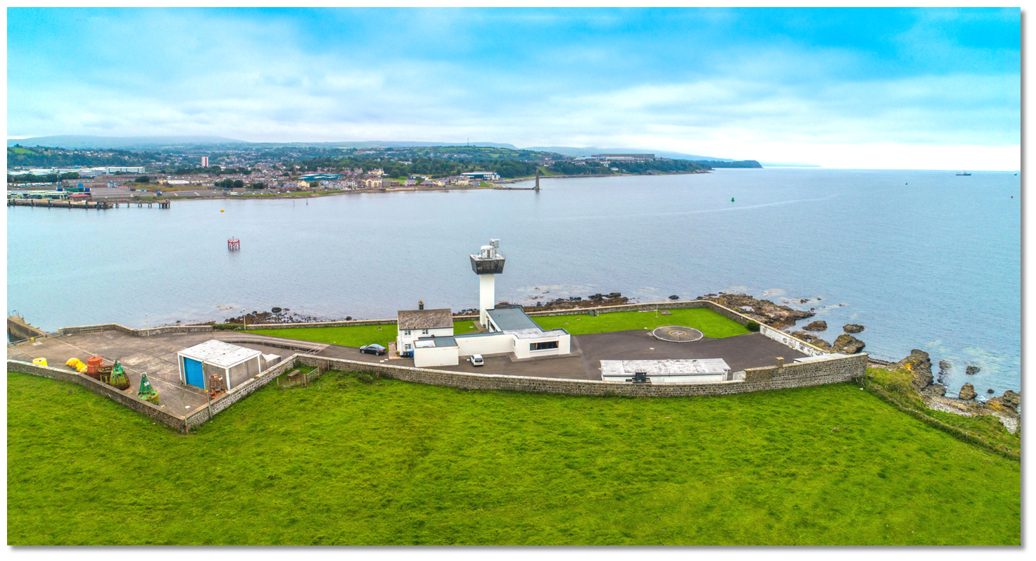
Ferris Bay is a small northwest-facing bay situated upon the entrance to Larne Lough and between the Islandmagee peninsula’s inner promontories. It is entered between Barr’s Point and Ferris Point, a ½ mile southwestward, and shoals gradually to a low sandy foreshore in a rural setting. Ferris Point Lighthouse and the watch tower of the Port Control Office is situated on Ferris Point making the bay unmistakable.
 Ferris Bay's pretty beach
Image: Michael Harpur
The bay offers an anchorage with good holding and ample depths and a nice beach to land upon with road access.
How to get in?
 Ferris Bay on the eastern side of the entrance to Larne Lough
Image: Michael Harpur
 The bay is immediately outside the entrance to Larne Lough and directions for Larne Harbour may be used for approaches. Vessels approaching Ferris Bay have to pass into the limits of Larne Port Control and must make Larne Port Control aware of the intentions to anchor in the bay. Larne Port Control is may be contacted on [VHF] Ch. 14 [Larne Port Control] or by +44 28 28 872179. Larne Port Control can advise on ship movements, weather, tide, etc. Leisure craft should take care not to impede commercial traffic approaching Larne.
  Larne Port Control as seen from the beach at the head of Ferris Bay
Image: Michael Harpur
The key local dangers to avoid are the rocky outcrops that extend from the three northern points of the Islandmagee. Of these Skernaghan Point’s rocky outcrop that stretches northward from the northernmost point of Islandmagee is the most dangerous. Skernaghan Point, which translates to 'point of the reef' has been responsible for numerous shipwrecks and should be given a berth of at least 500 metres. This is particularly in the way of a vessel following the coastline from the south and it is essential to take care to stand well off the point. Likewise, vessels approaching should keep at least 200 metres off the ends of Barr's and Ferris Points.
 Larne Port Control overlooking the bay from Ferris Point
Image: Michael Harpur
 From the Larne Harbour initial fix, situated midway between the No. 1 Green buoy Q (3) 10s and the No. 2 Red buoy Fl (2) R 6s, set a course of 160° T to pass close by the No. 2 port hand buoy and continue for a ½ mile into Ferris Bay keeping Ferris Point well to starboard. The conspicuous square white watch tower of the Port Control Office, with a radar scanner on top and surrounding white walls, that stands on Ferris Point renders the bay unmistakable.
 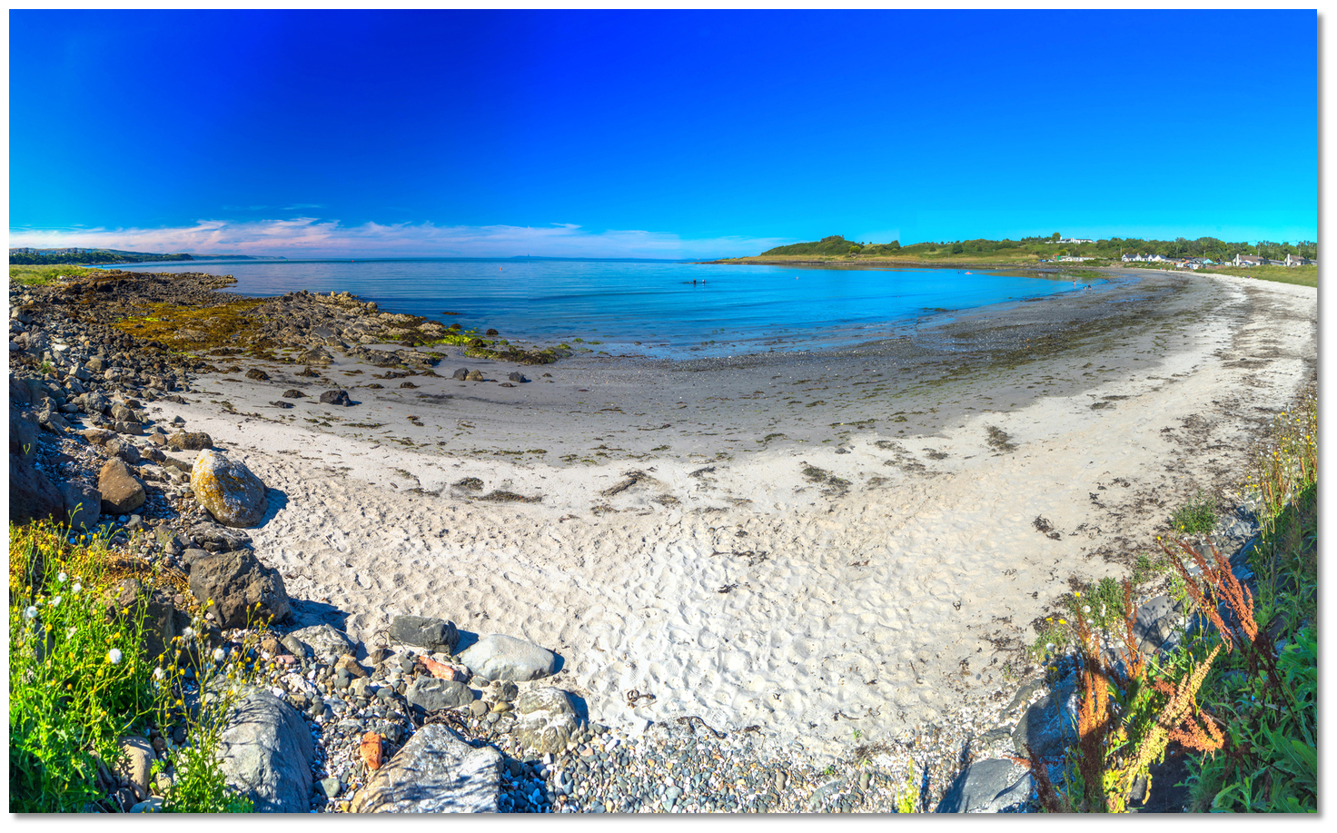 Anchor off the beach according to conditions
Image: Michael Harpur
Anchor according to draft and conditions. The 2-metre contour is reached before the tower climbs to a bearing of 200° T, about 2000 metres from the shore and the head of the bay shallows abruptly thereafter so stay well offshore of the beach. Very good holding will be found here over sand. Land by dinghy on the sandy beach at the head of the bay.
Why visit here?
The surname Ferris could derive either from the Irish name 'Fergus', which means 'strong man'/ 'man of vigour', or from the English surname ' Ferrers', referring to a blacksmith or ironworker. The origin of how it was used to name Ferris Bay and Point is however unknown. How Ferris Bay acquired its name is unknown
Image: Michael Harpur
Today the point and small rural bay's single most conspicuous feature is the Port Control Office building that stands on the point marking the east side of the narrow entrance into Larne Lough. Constructed in 1976 the space-age black glass box in a white tower is an ultra-modern structure that replaced a traditional lighthouse that once showed a light from here.
 Postcard depicting the original Larne Lough Lighthouse
Image: Public Domain
The lighthouse usability slowly came to an end after the Ballylumford power station opened in 1943 and the port of Larne ferry trade started to grow. Then the installations of these near neighbours increasingly began to obscure the lighthouse; the power station chimneys behind confused its position during the daytime and the Larne Harbour floodlights by night. The light was finally made redundant in 1976 when a directional light was installed at Chaine Tower Lighthouse on the western side of the harbour entrance.
 Larne Port Control Office
Image: Michael Harpur
The remarkable granite tower, known locally as 'The Pencil' is an accurate replica of an Irish Round Tower and stands 27 metres high and 7.5 metres wide at its base. It was originally built in 1887 as a memorial for James Chaine, the developer of Larne Harbour, with money raised by public subscription in Larne. The modernised Ferris Point building remains the base for the Larne Port Control and the maintenance base for the buoys and the Maidens light plus it also provides a Helipad.
 Larne Port Control with the Chaine Memorial Tower opposite
Image: Michael Harpur
George Halpin also designed and supervised the erection of the Maidens lighthouses which were built almost a decade before the Larne Lough Lighthouse in 1829. Situated five miles from Ferris Point and steep-to all round these dangers consist of two clusters of rocks called the West and East Maiden, separated from each other by a deep and wide sound. They marked the dangers by building two lighthouse towers 750 metres apart, one on each rock cluster. The keepers of the lighthouses and their families originally lived on site for the whole year and the isolation led to a remarkable 1830s romance. Rowing across the sound that separated the towers the assistant keeper of one lighthouse fell in love with the daughter of the keeper of the other. But the families were uncomfortable with the relationship and fell out. When the father forbade his daughter to meet the assistant keeper, the couple ran off to Carrickfergus where they eloped.
 The inactive West Maidens Lighthouse
Image: Alvaro via CC BY SA 2.0
In 1903 an improved light was exhibited on the Maidens East Lighthouse and the West Tower light was discontinued. In 1906 Maidens Lighthouse became a combined station with the light at Ferris Point, with the Principal Keeper of Ferris Point Lighthouse responsible for both. Shore dwellings for the families of the four Maidens' assistant keepers were built at Ferris Point. Three of the assistant keepers were on duty on Maidens at any time. Each assistant keeper, in turn, spent 30 days on Maidens Lighthouse followed by 10 days ashore with his family at Ferris Point. In 1977 the keepers were permanently withdrawn after the station was converted to automatic operation. The lights at the Maidens and Chaine Tower are now monitored by remote control.
 East Maiden
Image: David Maxfield via CC BY-SA 3.0
Barr’s Point bounds the eastern side of Ferris Bay and this may be very interesting to golfers as it is home to a testing and picturesque golf course. The nine-hole course has been in existence for over 100 years and is part parkland and part links, with views east reaching as far as Scotland. The clubhouse, a short stroll from the landing beach, has full catering and bar facilities where visitors are always welcome. A footpath follows the road to the east past the golf course to the sandy beach at Brown’s Bay where there is a small shop and a walk out to the point. But for many, the pretty little beach may be all that is needed for an afternoon.
 On a fine day Ferris Bay's beach can be more than enjoyable
Image: Michael Harpur
From a purely boating point of view, Ferris Bay is an alternative anchorage to its larger neighbouring and very popular Brown’s Bay. Although a little overgrown, it is a picturesque little bay that overlooks the mainland to the north. It is a shorter stroll from here to the Ballylumford Ferry and it may provide a good alternative if Brown’s Bay is experiencing some swell.
What facilities are available?
Ferris bay has road access and the Larne Golf Club, where full catering and bar facilities are available and visitors are always welcome, but little else. Public Toilets are available in the adjacent Brown's Bay where there is Steele's shop that has some provisions plus a post office.All other facilities are available in Larne Harbour half a mile distant and serviced by the small ferry from Ballylumford that takes 5 minutes to cross the mouth of the lough. There is a footway for the short distance from Ferris bay to Ballylumford where the small passenger ferry departs. The small ferry takes no more than 12 people and booking is essential P +44 28 2827 3785.
Any security concerns?
Never a problem known to have occurred in Ferris Bay.With thanks to:
Terence Stitt, Portmuck Harbour Master.Aerial views of Larne including Ferris Bay
Canoeists visit The Maidens
About Ferris Bay
The surname Ferris could derive either from the Irish name 'Fergus', which means 'strong man'/ 'man of vigour', or from the English surname ' Ferrers', referring to a blacksmith or ironworker. The origin of how it was used to name Ferris Bay and Point is however unknown.
How Ferris Bay acquired its name is unknownImage: Michael Harpur
Today the point and small rural bay's single most conspicuous feature is the Port Control Office building that stands on the point marking the east side of the narrow entrance into Larne Lough. Constructed in 1976 the space-age black glass box in a white tower is an ultra-modern structure that replaced a traditional lighthouse that once showed a light from here.
Postcard depicting the original Larne Lough LighthouseImage: Public Domain
The lighthouse usability slowly came to an end after the Ballylumford power station opened in 1943 and the port of Larne ferry trade started to grow. Then the installations of these near neighbours increasingly began to obscure the lighthouse; the power station chimneys behind confused its position during the daytime and the Larne Harbour floodlights by night. The light was finally made redundant in 1976 when a directional light was installed at Chaine Tower Lighthouse on the western side of the harbour entrance.
Larne Port Control OfficeImage: Michael Harpur
The remarkable granite tower, known locally as 'The Pencil' is an accurate replica of an Irish Round Tower and stands 27 metres high and 7.5 metres wide at its base. It was originally built in 1887 as a memorial for James Chaine, the developer of Larne Harbour, with money raised by public subscription in Larne. The modernised Ferris Point building remains the base for the Larne Port Control and the maintenance base for the buoys and the Maidens light plus it also provides a Helipad.
Larne Port Control with the Chaine Memorial Tower oppositeImage: Michael Harpur
George Halpin also designed and supervised the erection of the Maidens lighthouses which were built almost a decade before the Larne Lough Lighthouse in 1829. Situated five miles from Ferris Point and steep-to all round these dangers consist of two clusters of rocks called the West and East Maiden, separated from each other by a deep and wide sound. They marked the dangers by building two lighthouse towers 750 metres apart, one on each rock cluster. The keepers of the lighthouses and their families originally lived on site for the whole year and the isolation led to a remarkable 1830s romance. Rowing across the sound that separated the towers the assistant keeper of one lighthouse fell in love with the daughter of the keeper of the other. But the families were uncomfortable with the relationship and fell out. When the father forbade his daughter to meet the assistant keeper, the couple ran off to Carrickfergus where they eloped.
The inactive West Maidens LighthouseImage: Alvaro via CC BY SA 2.0
In 1903 an improved light was exhibited on the Maidens East Lighthouse and the West Tower light was discontinued. In 1906 Maidens Lighthouse became a combined station with the light at Ferris Point, with the Principal Keeper of Ferris Point Lighthouse responsible for both. Shore dwellings for the families of the four Maidens' assistant keepers were built at Ferris Point. Three of the assistant keepers were on duty on Maidens at any time. Each assistant keeper, in turn, spent 30 days on Maidens Lighthouse followed by 10 days ashore with his family at Ferris Point. In 1977 the keepers were permanently withdrawn after the station was converted to automatic operation. The lights at the Maidens and Chaine Tower are now monitored by remote control.
East MaidenImage: David Maxfield via CC BY-SA 3.0
Barr’s Point bounds the eastern side of Ferris Bay and this may be very interesting to golfers as it is home to a testing and picturesque golf course. The nine-hole course has been in existence for over 100 years and is part parkland and part links, with views east reaching as far as Scotland. The clubhouse, a short stroll from the landing beach, has full catering and bar facilities where visitors are always welcome. A footpath follows the road to the east past the golf course to the sandy beach at Brown’s Bay where there is a small shop and a walk out to the point. But for many, the pretty little beach may be all that is needed for an afternoon.
On a fine day Ferris Bay's beach can be more than enjoyableImage: Michael Harpur
From a purely boating point of view, Ferris Bay is an alternative anchorage to its larger neighbouring and very popular Brown’s Bay. Although a little overgrown, it is a picturesque little bay that overlooks the mainland to the north. It is a shorter stroll from here to the Ballylumford Ferry and it may provide a good alternative if Brown’s Bay is experiencing some swell.
Other options in this area
Click the 'Next' and 'Previous' buttons to progress through neighbouring havens in a coastal 'clockwise' or 'anti-clockwise' sequence. Alternatively here are the ten nearest havens available in picture view:
Coastal clockwise:
Brown’s Bay - 0.4 miles ENEPortmuck - 1.3 miles E
Whitehead - 4.2 miles SSE
Carrickfergus Harbour & Marina - 5.3 miles S
Greenisland - 6.1 miles SSW
Coastal anti-clockwise:
Larne Harbour - 0.5 miles SSEBallydowan - 1 miles SSE
Mill Bay - 1.2 miles SSE
Magheramorne Point - 1.2 miles SSE
Ballygalley Bay - 2.4 miles NW
Navigational pictures
These additional images feature in the 'How to get in' section of our detailed view for Ferris Bay.


| Detail view | Off |
| Picture view | On |
Aerial views of Larne including Ferris Bay
Canoeists visit The Maidens
Add your review or comment:
Please log in to leave a review of this haven.
Please note eOceanic makes no guarantee of the validity of this information, we have not visited this haven and do not have first-hand experience to qualify the data. Although the contributors are vetted by peer review as practised authorities, they are in no way, whatsoever, responsible for the accuracy of their contributions. It is essential that you thoroughly check the accuracy and suitability for your vessel of any waypoints offered in any context plus the precision of your GPS. Any data provided on this page is entirely used at your own risk and you must read our legal page if you view data on this site. Free to use sea charts courtesy of Navionics.