
.jpg)
The basin provides complete protection. Safe access is available night or day, at any stage of the tide in all reasonable conditions.


Keyfacts for Belfast Harbour


Nature


Considerations


Protected sectors


Summary
A completely protected location with safe access.Nature
Considerations
 +44 28 9055 4422 Berthing +44 7760 994176
  info@belfast-harbour.co.uk
  belfast-harbour.co.uk/port/marina/
  Ch.12 & 16
 Position and approaches

Haven position
 54° 36.300' N, 005° 54.860' W
This is position of the Abercorn Basin where the recreational vessel berths are located.
What is the initial fix?
 54° 41.710' N, 005° 46.225' W


What are the key points of the approach?
 .
.- Approaches to the lough can be found in the Bangor Harbour
 entry.
 - Track into the Fairway Light buoy through Belfast Lough's open navigable area that is free of dangers.
- Enter the channel and follow it into the Abercorn Basin under power taking care not to impede commercial traffic.
Not what you need?
- Newtownabbey - 4.7 nautical miles NNE
- Cultra - 4.8 nautical miles NE
- Greenisland - 5.7 nautical miles NNE
- Carrickfergus Harbour & Marina - 7.3 nautical miles NNE
- Helen’s Bay - 7.6 nautical miles NE
- Bangor Harbour & Marina - 9.2 nautical miles ENE
- Ballyholme Bay - 9.9 nautical miles ENE
- Groomsport - 11.2 nautical miles ENE
- Whitehead - 11.3 nautical miles NE
- Ballydorn and Down Cruising Club - 11.5 nautical miles SE
- Newtownabbey - 4.7 miles NNE
- Cultra - 4.8 miles NE
- Greenisland - 5.7 miles NNE
- Carrickfergus Harbour & Marina - 7.3 miles NNE
- Helen’s Bay - 7.6 miles NE
- Bangor Harbour & Marina - 9.2 miles ENE
- Ballyholme Bay - 9.9 miles ENE
- Groomsport - 11.2 miles ENE
- Whitehead - 11.3 miles NE
- Ballydorn and Down Cruising Club - 11.5 miles SE

Chart

What's the story here?
 The marina on the southeast side of the river in the Abercorn Basin
Image: Belfast Titanic via CC BY 4.00
Belfast Harbour is situated at the head of Belfast Lough within the entrance and navigable section of the River Lagan. It is the busy port of the capital city that is also the manufacturing and commercial heart of Northern Ireland. Belfast Harbour Commissioners welcomes visiting vessels to the port and it hosts them in a marina located on the southeast side of the river in the city's refurbished Titanic Quarter at Abercorn Basin. This is in the heart of a large-scale waterfront regeneration, comprising historic maritime landmarks, riverside entertainments and Titanic-themed attractions but is also a short walk from the centre of the city.
 Belfast Marina overlooked by the Titanic Museum
Image: Belfast Titanic via CC BY 4.00
The marina consists of 85 full-service berths that can accommodate recreational vessels up to 15 metres LOA with a maximum draught of 4.0 metres. Larger vessels are accommodated by arrangement with the port office. Vessels less than or equal to 15 metres are charged a flat fee of [2023] £25.00 per day, less for short stops, via an automated berth payment system at the bottom of the gangway. Berthing arrangments are on a 'first come, first served basis' and made with the Port Office
Ch. 12/16 [Belfast Harbour Radio], +44 (0)28 9055 4422, the Abercorn Basin Marina  +44 (0)7760 994176, info@belfast-harbour.co.uk or via the marina website
  .
.How to get in?
 Belfast Harbour at the head of Belfast Lough
Image: Tourism NI
 Use the Malin Head to Strangford Lough coastal overview for coastal approaches and Bangor Harbour for approaches to Belfast Lough. From which a track to the Belfast Fairway Light buoy, L Fl 10s, which is situated in the middle of the lough between Carrickfergus and Grey Point on the opposite shore.
  Belfast Fairway Light Buoy
Image: © Alan Geddes
All vessels are required to report to,
Ch. 12/16 [Belfast Harbour Radio] or by telephone at +44 (0)2890 553504, well in advance of arrival and advise them of intentions. The following Belfast Harbour Radio contacts are prerequisites for all craft lough proceeding west of a charted line drawn from Carrickfergus to Grey Point:
- 1. Two hours prior to arrival at the Fairway Buoy or entry point.
- 2. Fifteen minutes prior to arrival at the Fairway Buoy or entry point.
- 3. When Passing No. 12 Beacon (one mile out from the river mouth).
- 4. When arriving at the berth.
Vessels must maintain a listening watch on VHF Ch. 12 whilst within the harbour limits. The maximum speed in the harbour area, south of the Number 12 beacon, is 6 knots.
 Ferry exiting via the Victoria Channel
Image: Tourism NI
 The Belfast Harbour Initial Fix is the position of Belfast Fairway Light Buoy, L Fl 10s, situated in the middle of the lough between Carrickfergus and Grey Point on the opposite shore. The initial fix sets up an approach via the dredged Victoria Channel. This is the preferred route and the one that the harbour authorities encourage visiting vessels to use.
  Collision Regulations apply in the Victoria Channel so do not impede large ships
Image: Belfast Titanic via CC BY 4.00
From the initial fix, steer to pass between the No. 1 Green buoy, starboard hand marker, Fl2 G (sync) and the No. 2 Red buoy, port hand marker Fl2 R 2s (sync) 2½ miles west by southwest. These mark the entrance to the Belfast Lough's Victoria Channel that leads in through the head of the lough and through the harbour’s extensive port walls on both sides. Once within the Victoria Channel, it is simply a matter of following the frequent and closely spaced light beacons all the way into the harbour; green odd-numbered beacons mark the northwest side and red even-numbered beacons mark the southeast side. The total length of travel from the Fairway Light buoy to the berth is 7½ miles.
 The Lagan River to the Abercorn Basin
Image: Belfast Titanic via CC BY 4.00
The Victoria Channel is a 'narrow channel' meaning Rule 9 of the Collision Regulations applies, so keep to the right and do not impede large ships under any circumstances. Plenty of water will be found close outside the northeast, or starboard, side of the channel up to the No.13 beacon. Beyond this, it shallows particularly so on the southwest port side, where the Holywood Bank dries almost out to the marks.
 The run up the Lagan River to the Abercorn Basin
Image: Belfast Titanic via CC BY 4.00
Once inside the River Lagan entrance, Belfast Docks' extensive port installations will be seen on both sides. Continue down the Victoria Channel until Herdman Channel will be seen, branching off to the north side, and Musgrave Channel, branching off to the south side. Ignore both these side channels and continue down the middle between the heads of West Twin and East Twin Islands, into the Lagan River.
 The Abercorn Basin entrance as seen from upriver on the opposite side
Image: William Murphy via CC BY SA 2.0
The Abercorn Basin will be found just under 1½ miles from this branch point. It is situated on the southeast, port side, just beyond the Titanic Museum building and adjacent to the highly conspicuous huge domed Odyssey Pavilion on Queen's Quay.
 Belfast Harbour Marina The pontoons are located on the southwest side of the basin immediately adjacent to the Odyssey Pavilion. 240 metres of pontoons supporting 40 berths will be found and the Basin is dredged to 4 metres.
 Belfast Harbour Marina
Image: Daniel Sczepansky via CC ASA 3.0
Credit/Debit Card payment must be made on arrival at one of the ticket machines situated on the main pontoon at the base of the entrance bridge. Visitors will be asked to input their vessel LOA, berth number(s) and the planned duration of their stay.
 Belfast Harbour Marina as seen from the opposite side of the basin
Image: William Murphy via CC BY SA 2.0
Retain the provided receipt as it contains the access gates' security code information on the back.
 The Lagan Weir beyond the Lagan Bridge upriver
Smaller power craft may find further pontoons at the Lagan Weir beyond the Lagan Bridge. The Lagan Bridge is located 400 metres upstream or southwest of the entrance to the Abercorn Basin and it has an airdraft of less than 8 metres above chart datum or 3.5 metres MHWS. The pontoons are located 150 metres upstream at the Lagan Weir. These pontoons are a Northern Ireland government facility operated by the Dept of Social Development.
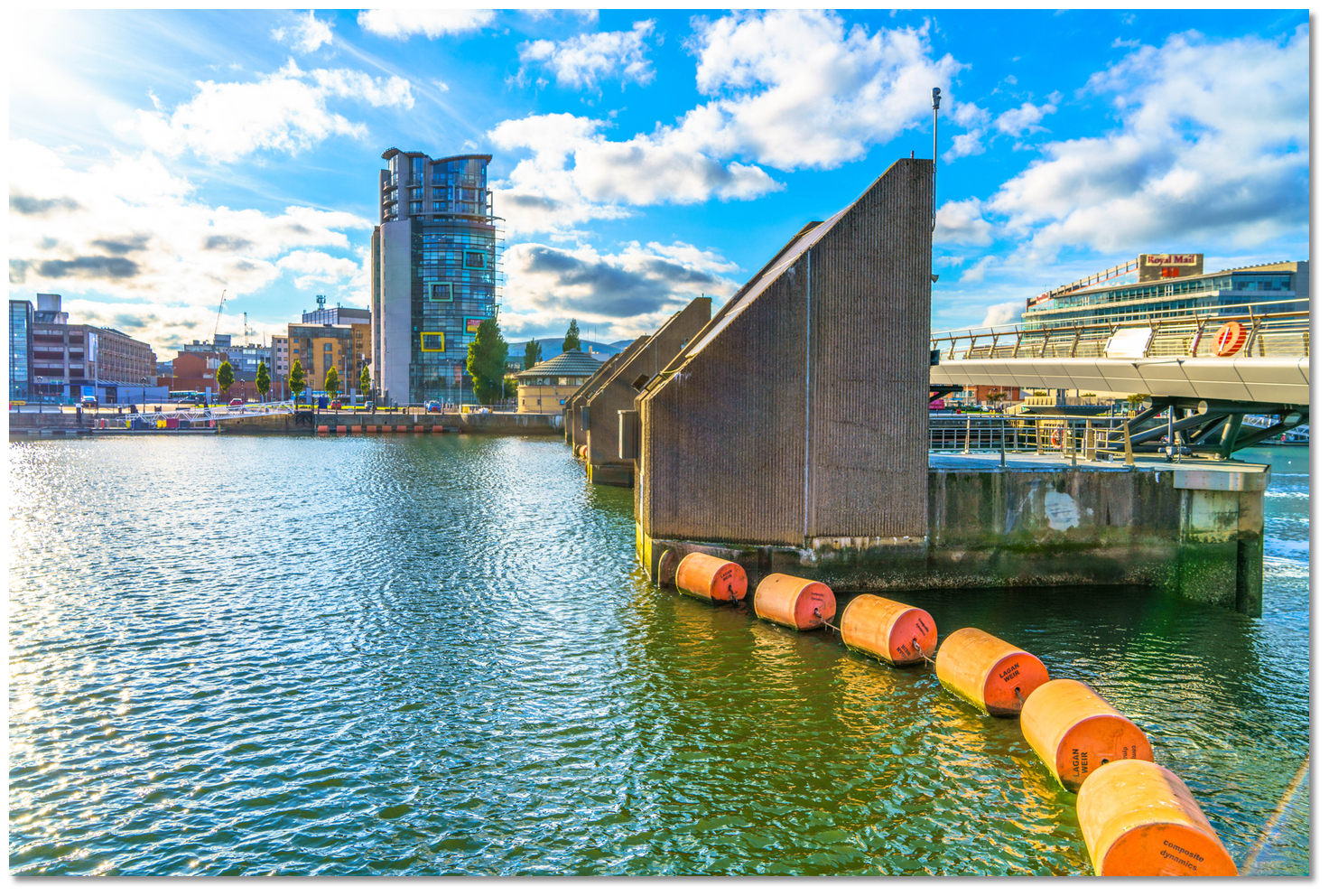 The Lagan Weir
Image: William Murphy via CC BY SA 2.0
The Lagan Weir protects the city from very high tides and retains navigable water in the river at low tide. When the Weir opens low airdraft vessels, drawing less than 1.5 metres, may continue 3 miles upriver to the Stranmillis Weir; pass through gate 2 to go upriver and return through gate 4.
Why visit here?
Belfast derives its name from the Irish 'Béal Feirste' that translates to 'mouth of the sandbars'. The sandbar referred to was across the mouth of the River Lagan and situated near where the little River Farset joined it. This small river that now flows below High Street to enter the Lagan was also named from the name for a 'bank' or 'ford', 'feirste' over time moving to 'fearsaid' to Farset. Cave Hill overlooking Belfast City
Image: Tourism NI
Belfast's human occupation reaches back to the Bronze Age. This is evidenced by the Megalithic 'Giant's Ring' henge located near the city that dates back over 5000 years. Later remains of Iron Age hill forts, such as McArt's Fort on top of Cave Hill, may also be seen in the hills surrounding the city.
 Belfast Castle
Image: Tourism NI
The original settlement of Belfast is thought to have been little more than a village based around the marshy ford provided by the conjunction of the Rivers Lagan and Farset. The first note of it was made as early as AD 665 when it was described in the account of a battle fought at the site. In 1177 John de Courcy, the leader of the Anglo-Norman conquest of Ulster, built a castle here to protect and dominate the position. It was attacked, recovered, destroyed and rebuilt many times until it was eventually destroyed by fire in 1708.
 Victorian Belfast City Hall completed in 1906
Image: Tourism NI
However, during all this time Belfast remained a small settlement of little importance that was continually overshadowed by Carrickfergus, the Norman administrative headquarters, to the northeast. This changed with the 17th-century Plantation of Ulster when Belfast became a substantial settlement. No one had effectively wrestled control of this area from the Ulster Gaelic Clans until King James granted it to Sir Arthur Chichester.
 Stormont Parliament Building completed 1932
Image: Tourism NI
Chichester, a major exponent of the Plantation, rebuilt Belfast Castle in 1611 and took firm control of the area. This transformed the region and soon a small town grew around the castle hosting a population of about 1,000. The planters were industrious trading in wool, hides, grain, butter and salted meat that were exported from Belfast to England, Scotland and France. Wine and fruit were imported from France and Spain. At the latter end of the 17th century, Belfast traded with the North American colonies and tobacco and sugar were imported from the West Indies and refined in Belfast. Other associated industries grew around this trade including brewing, rope making and sail making. By then the population had about doubled to around 2,000 and it was then swelled by French Protestants. They were fleeing religious persecution in their own country and by arriving in Belfast they brought with them linen weaving skills.
 Titanic under construction in the Harland & Wolff yard
Image: Public Domain
By the early 18th century, the town had replaced Carrickfergus as the most important port in Ulster and additional accommodation was necessary for its very busy harbour. Many privately owned wharves were subsequently constructed on reclaimed land. Throughout the century trade continued to expand as Belfast assumed a greater role in the trading activities of the country as a whole. The rope-making industry thrived during the 19th century but it was linen that steadily grew to become Belfast's dominant industry. Linen was first woven in people's homes in the surrounding countryside and was not industrialised until the middle of the 19th century. Cotton spinning was introduced into Belfast in 1777 but it never had the same importance that linen had for which Belfast had become a centre of excellence.
 Olympic and Titanic nearing completion
Image: Public Domain
By the 19th century Belfast had become Ireland's pre-eminent industrial city with linen, heavy engineering, tobacco and shipbuilding dominating the economy. In the middle of the 19th century, there were several iron foundries in Belfast, and in the late 19th century a large engineering industry grew up. It was this, combined with the ideal estuarial location, that made it the location for the shipbuilding industry, and Belfast became home to one of the largest shipbuilders in the world, Harland and Wolff.
 The Titanic Memorial in Belfast City Hall that was dedicated in June 1920
Image: Tourism NI
At its peak Harland and Wolff, employing up to 35,000 workers was considered the greatest and most productive shipbuilding company globally. Migrants came to Belfast from across Ireland, Scotland and England, but particularly from rural Ulster to work in the yard and the surrounding industrial powerhouse that the city had become. For a short time, it overtook Dublin as the largest city in Ireland. But with this infusion came the first sectarian tensions marked by riots, which have become synonymous with the city.
 Titanic's Dry Dock today
Image: Tourism NI
It was during the industrial peak that the world-leading Harland and Wolff shipyard created a ship that would capture the imagination of the world and propel Belfast onto the global stage. This was the ill-fated RMS Titanic; the most famous sailing vessel in maritime history.
 Harland & Wolff Cranes Samson and Goliath and dry dock today
Image: Tourism NI
In its day the RMS Titanic was the largest passenger steamship ever built. Launched in 1911 she set off on her maiden voyage in 1912. Four days into the crossing, from Southampton to New York City, it struck an iceberg and sank in less than three hours. It took 1,517 people with her of which many were from the elite or leading figures of the time. It remains to this day one of the deadliest peacetime maritime disasters in history.
 Titanic Museum
Image: Belfast Titanic via CC BY 4.00
Today, the story of this vessel is remembered in the Titanic Quarter directly adjacent to the berthing area in the Abercorn Basin which opened 100 years after the Titanic set sail. The world's largest Titanic-themed visitor attraction is part of a large-scale waterfront regeneration project on 185 acres (75 ha) of the once Harland and Wolff shipyard.
 Titanica sculpture in front of Titanic Belfast
Image: Belfast Titanic via CC BY 4.00
Comprising historic maritime landmarks, film studios, education facilities, apartments, and a riverside entertainment district it pays tribute to Belfast Harbour, the city and the technical talent that made the Titanic engineering world-beating. In its first 12 months, over 700,000 people visited the Titanic Quarter exceeding all forecasts.
 The museum's replica of Titanic's grand staircase
Image: Belfast Titanic via CC BY 4.00
Today Belfast is the second largest city in all of Ireland and is Northern Ireland's capital. It remains a centre for business and industry, featuring aircraft production, brewing, flour milling, pharmaceuticals and other light industries. It is also a centre for the arts, higher education, law, and culture and is the engine of Northern Ireland. The harbour itself remains equally significant. Today it still handles over 60% of Northern Ireland's sea-borne trade and 20% of Ireland's as a whole.
 Belfast Harbour Marina provides a berth that is steeped in maritime history
Image: Tourism NI
From a boating perspective, the Abercorn Basin provides excellent shelter from all winds and safe easy access. It is one of the safest harbours to run to along this coast. But it also places a boatman in the heart of this historic city with its extensive facilities within a 20-minute walk from the pontoons. It also offers a rare and unique historic connection, a berth in the Harland and Wolff's cradle of the 'Titanic Port' with Belfast's Maritime Mile to be explored immediately ashore set off by the magnificent Titanic Museum.
What facilities are available?
Drinking water and electricity are provided to all berths 24hrs daily. Waste and recycling facilities are available at the base of the bridge, and public toilets are available in the Odyssey complex during opening hours together with public payphones and paid car parking.The pontoon is a ten minute walk from the city centre which has all the facilities to service an urban population of more than a quarter of a million. Thus it has to offer a wide variety of excellent restaurants, bars, shopping, museums, galleries and all other facilities, including a sailmaker.
Belfast has excellent transport connections via trains and bus services to any location in Ireland. Flights to domestic and international destinations operate from Belfast International Airport, the main regional airport, and George Best Belfast City Airport. There are more than 80 weekly ferry sailings from Belfast to UK ports.
Any security concerns?
The facility is monitored by CCTV security cameras. Secure access is gained by a gate code which can be found on the reverse of the receipt provided by the fee payment ticket machine.With thanks to:
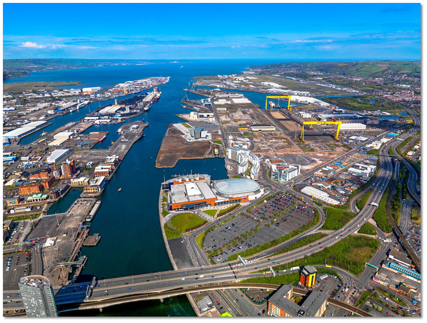
Michael Evans, Deputy Harbour Master, Belfast Harbour.Aerial overview of the Titanic Quarter


Add your review or comment:
Ron Lub wrote this review on Jun 17th 2019:
Good place when you’re visiting Belfast. 18 pound a night free electricity, showers and washing/drying machine!
This week they started to make more pontoons in this basin so more room for visiting yachts when ready!


Please log in to leave a review of this haven.
Please note eOceanic makes no guarantee of the validity of this information, we have not visited this haven and do not have first-hand experience to qualify the data. Although the contributors are vetted by peer review as practised authorities, they are in no way, whatsoever, responsible for the accuracy of their contributions. It is essential that you thoroughly check the accuracy and suitability for your vessel of any waypoints offered in any context plus the precision of your GPS. Any data provided on this page is entirely used at your own risk and you must read our legal page if you view data on this site. Free to use sea charts courtesy of Navionics.