
The shelter at the anchorages is good in all reasonable weather conditions though they may be troubled by a westerly swell. Access is straightforward when unaffected by weather or tidal considerations, but a depth check may be required if using the southern entrance to the Sound.
Keyfacts for Arranmore Island


Nature


Considerations
Protected sectors


Summary
A good location with straightforward access.


Nature


Considerations
Position and approaches
Haven position
 54° 59.314' N, 008° 29.711' W
this is the position at Leabgarrow pierhead on the east side of the island
What is the initial fix?
 55° 2.410' N, 008° 30.085' W
 Not what you need?
- Rutland Harbour & Island - 1.1 nautical miles ESE
- Burtonport - 1.8 nautical miles ESE
- Cruit Bay - 4.2 nautical miles NE
- Owey Island - 4.3 nautical miles NNE
- Bunbeg - 7.5 nautical miles ENE
- Gola Island - 7.8 nautical miles NE
- Church Pool & Portnoo - 8.7 nautical miles S
- Inishsirrer Island - 9.6 nautical miles NE
- Dawros Bay - 10.2 nautical miles S
- Toberglassan Bay - 16 nautical miles NE
- Rutland Harbour & Island - 1.1 miles ESE
- Burtonport - 1.8 miles ESE
- Cruit Bay - 4.2 miles NE
- Owey Island - 4.3 miles NNE
- Bunbeg - 7.5 miles ENE
- Gola Island - 7.8 miles NE
- Church Pool & Portnoo - 8.7 miles S
- Inishsirrer Island - 9.6 miles NE
- Dawros Bay - 10.2 miles S
- Toberglassan Bay - 16 miles NE
Chart
How to get in?
 The 'Erris Head to Malin Head' coastal description provides approach information to the suggested initial fix. Vessels approaching from the south should select the northeast bound
  sequenced description; vessels approaching from the north should select the southwest bound
  sequence; western approaches may use either description.
Arranmore, Irish : Arainn Mhoir meaning Large Ridge, is part of the Rosses district of County Donegal, and the Rosses epitomise Ireland's quirky approach to the spelling of place names.
To add to the confusion there are the South Sound and a quite distinct South Sound of Aran. We will go with the local usage and refer to the island as Arranmore.
Up to the Bloody Foreland the passage along the coast has many potential anchorages in attractive scenic surroundings sheltered by several islands, and with reasonably straightforward navigation it makes this area an attractive location for the cruising yachtsman. Some of the best cliff scenery in Ireland can be found on the west side of the island.
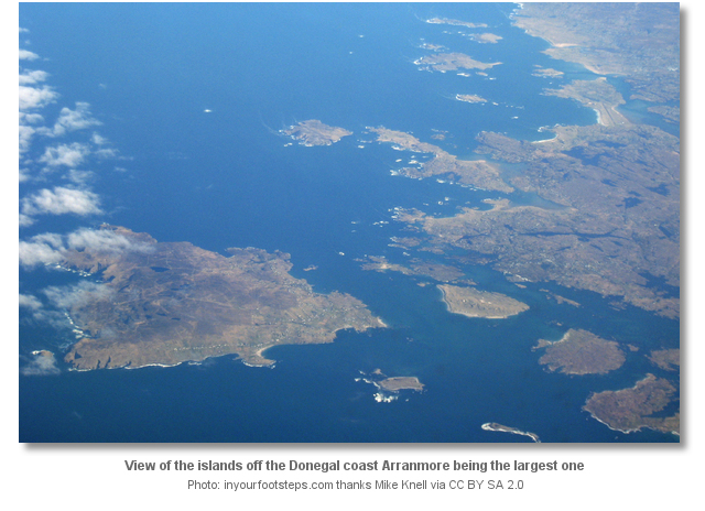
Round the islands in Aran Sound there is a selection of good anchorages to choose from, and the usual entrance to the Sound is from the north which has a good depth.
The southern entrance can also be used in reasonable weather conditions and a high enough tide, as the depth is only 0.3 metres off the southeast coast of the island.
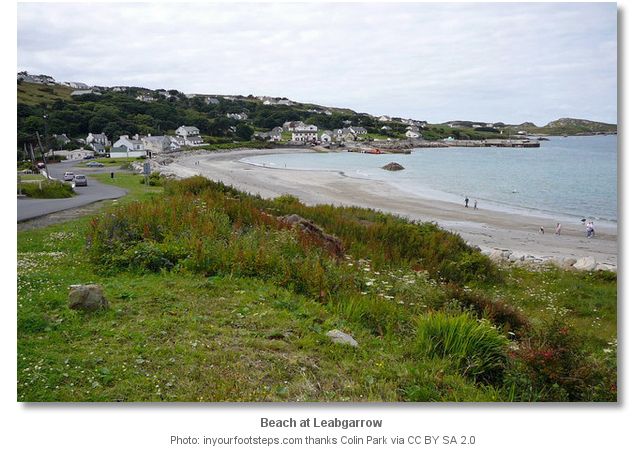
 The main anchorage which has some moorings for visitors is to the north of Arranmore's largest village Leabgarrow, Irish : Leadhb Gharbh, midway up the east coast. This anchorage is to the south of Calf Island and has a depth of about 3 metres, and from there a landing on to a sheltered sandy beach at Leabgarrow strand is possible. The strand is bounded in the north by two piers, and on the south by Charley's Point. The main pier at Leabgarrow is generally always very busy, as it is used by the ferrys to and from Burtonport on the mainland with sailings many times a day.
The other popular anchorages are on the south coast of the island, in Rossillion Bay in 2 metres depth east southeast of the pier, and next door to it in the smaller Chapel Bay in 4 metres depth south southwest of the quay. Both of these anchorages are good in northerly breezes but may be troubled by westerly swell.
Why visit here?
With an area of seven square miles and a resident population of about 600, Arranmore is Irelands second largest inhabited island. Arranmore is part of the Donegal Gaeltacht which is Irish speaking, and appropriately there is an Irish language college for young students located on the island. Historically the island's people have traditionally looked to the sea for their livelihood, or across it, as this part of Donegal used to send hundreds of migrant farmworkers to Scotland every year and many of todays islanders have family connections in Glasgow. Nowadays the island mostly relies on tourism for its income, as since the 1980's fishing is no longer a significant industry.Located on the east coast Leabgarrow is the islands main village and it is here and along the south coast where the islands population lives. The island has been settled since pre-Celtic times, and the few remaining signs of early settlement include a promontary fort to the south of the island and shell middens dotted along the beaches. Arranmore's position near the Atlantic shipping lanes was exploited, with a coastguard station and lighthouse situated on its most north westerly point, and a World War 2 monitoring post set up to look out for German U-Boats.
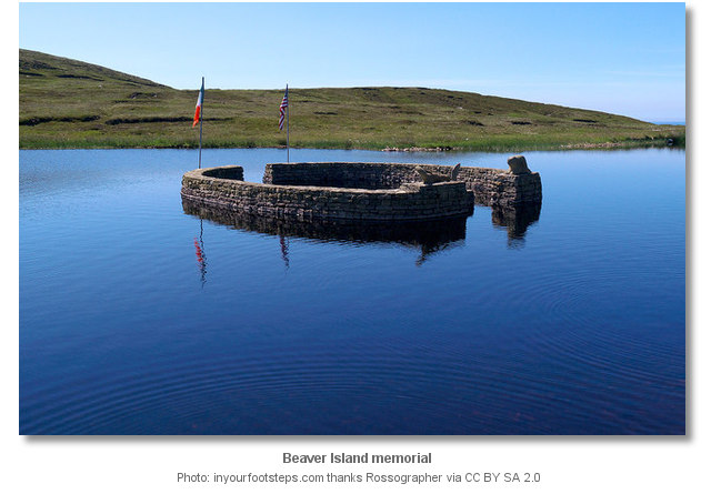
Before the Flight of the Earls at the start of the 17th century, the island was controlled by the O'Donnell Clan, of Donegal Castle, and was known as Ara Ui Dhomhnaill which in English means O'Donnell's Aran. During the Plantation of Ulster in the 17th century the island was granted to Lord Conyngham as was much of west Donegal at that time. It was during his ownership of Arranmore, a place he never once visited, that many of the islands people were forced to leave their homes due to starvation because of the Irish Famine. Many died on the island, several more in the poorhouse at Glenites and many aboard ships to Canada and America. Many of the islanders who survived the journey of emigration ended up on Beaver Island USA, an island in northern Lake Michigan part of the Great Lakes. Today Arranmore is twinned with Beaver Island and there are still a number of families on Beaver that can trace their roots back to Arranmore. At Lough Thoir on Arranmore there is a memorial erected commemorating the connection with Beaver Island and at the roadside there is a beautiful hand made Marian Shrine with an inscription remembering the people who left Arranmore to emigrate in the hope of a better life. Nearby the memorial there is a sign which points out to the Atlantic informing the reader that Beaver Island is 2,750 miles in that direction.
Walking, cycling, camping, birdwatching, boating, deep-sea and lake angling, diving and rock climbing are just some of the activities enjoyed on Arranmore. There are three sign-posted walks on the island which vary from a six hour round trip of the island taking in the lighthouse and the lakes, and others taking in the lakes and past main buildings of interest, and there are various picnic places located around the island. Boat trips are available to neighbouring islands, and can also be hired for deep-sea fishing usually for cod, ling, pollock, skate, turbot and plaice, whilst in the island's seven lakes brown trout is readily caught. A variety of seabirds including fullers and shags nest on the cliffs around the island, and the cliffs also hold nesting peregrine falcons. The waters surrounding the island are clear and unpolluted and are ideally suited to scuba diving, and the main climbing locations are at Rinawros Point and Trundlers Arete.
For the visiting yachtsman Arranmore has beautiful cliff scenery, stunning beaches and quiet country roads with abundant wildlife, a relaxed and friendly atmosphere and lively nightlife with traditional music sessions in most of its six pubs, some of which provide hot food. The island has a store for provisions, a post office, fuel by jerry can and gas refills available.
What facilities are available?
Fresh water, fuel by can and gas refills are all available on the island as well as a provisions store, post office, bars and pubs some with a restaurant, and internet access is available. There are convenient visitor moorings and a slipway, and regular ferry services to Burtonport on the mainland.With thanks to:
inyourfootsteps.com site research. Photography with thanks to Joseph Mischyshyn, Louise Price, Mike Knell, Niamh O'Mahony, Rossographer and Colin Park.


The following video presents a photo montage of Arranmore.
Add your review or comment:
Iain Miller wrote this review on Oct 19th 2017:
The Arranmore Island climbers guidebook http://uniqueascent.ie/arranmore_island
Rinrawros Point; https://www.youtube.com/watch?v=pqbAHGuFNWY&t=
Stac an Iolar; https://www.youtube.com/watch?v=e-G7trT2p6Q&t=
Please log in to leave a review of this haven.
Please note eOceanic makes no guarantee of the validity of this information, we have not visited this haven and do not have first-hand experience to qualify the data. Although the contributors are vetted by peer review as practised authorities, they are in no way, whatsoever, responsible for the accuracy of their contributions. It is essential that you thoroughly check the accuracy and suitability for your vessel of any waypoints offered in any context plus the precision of your GPS. Any data provided on this page is entirely used at your own risk and you must read our legal page if you view data on this site. Free to use sea charts courtesy of Navionics.


