
.jpg)
Though very small Lonehort Harbour offers complete protection and is one of the most sheltered of Bantry Bay’s outer harbours. However attentive navigation with the benefit of moderate weather and daylight is required for access. Though it may be entered at any state of the tide the channel is narrow and it is necessary to circle around a reef to enter the inner harbour.


Keyfacts for Lonehort Harbour
Facilities


Nature


Considerations


Protected sectors

Approaches

Shelter

Last modified
January 13th 2022 Summary* Restrictions apply
A completely protected location with careful navigation required for access.Facilities
Nature
Considerations
Position and approaches

Expand to new tab or fullscreen
Haven position
 51° 38.263' N, 009° 47.852' W
In the inner bay close to the northern shore
What is the initial fix?
The following Lonehort Harbour initial fix will set up a final approach:
 51° 38.127' N, 009° 47.177' W


What are the key points of the approach?
Offshore details are available in southwestern Ireland’s Coastal Overview for Mizen Head to Loop Head  .
.
. - The east-facing entrance is situated north of Leaghern's Point which may be positively identified by the mound (the butts) of a rifle range.
- Pass in between an isolated rock just off the Bere Island shoreline and Carrigvaud Rock that separates the outer and inner harbour.
- Circle clockwise around Carrigvaud to enter the inner harbour.
Not what you need?
Click the 'Next' and 'Previous' buttons to progress through neighbouring havens in a coastal 'clockwise' or 'anti-clockwise' sequence. Below are the ten nearest havens to Lonehort Harbour for your convenience.
Ten nearest havens by straight line charted distance and bearing:
- Lawrence Cove - 1.1 nautical miles W
- Mill Cove - 2.7 nautical miles WNW
- Adrigole - 4 nautical miles NE
- Castletownbere (Castletown Bearhaven) - 4.1 nautical miles W
- Dunboy Bay & Traillaun Harbour - 4.7 nautical miles W
- Ballynatra (Trá Ruaim) Cove - 5 nautical miles SSE
- Dooneen Pier - 5.1 nautical miles SSE
- Kilcrohane Pier - 5.4 nautical miles SE
- Kitchen Cove - 6.6 nautical miles ESE
- Ballycrovane Harbour - 7.4 nautical miles NW
These havens are ordered by straight line charted distance and bearing, and can be reordered by compass direction or coastal sequence:
- Lawrence Cove - 1.1 miles W
- Mill Cove - 2.7 miles WNW
- Adrigole - 4 miles NE
- Castletownbere (Castletown Bearhaven) - 4.1 miles W
- Dunboy Bay & Traillaun Harbour - 4.7 miles W
- Ballynatra (Trá Ruaim) Cove - 5 miles SSE
- Dooneen Pier - 5.1 miles SSE
- Kilcrohane Pier - 5.4 miles SE
- Kitchen Cove - 6.6 miles ESE
- Ballycrovane Harbour - 7.4 miles NW

Chart

What's the story here?
 Lonehort Harbour
Image: Óglaigh na hÉireann
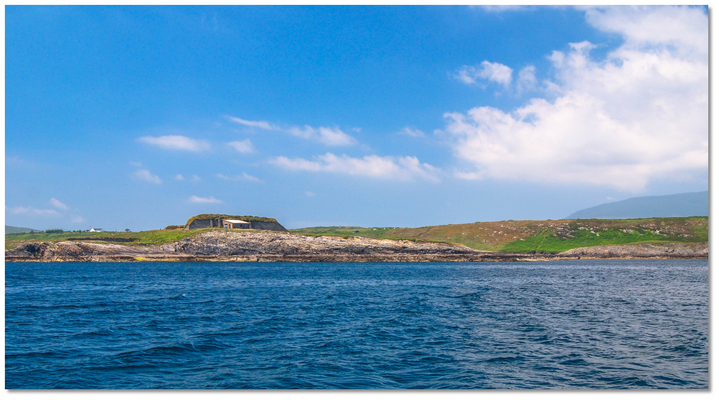
Lonehort Harbour is an ancient natural harbour situated on the south coast of Bear Island about a mile from its eastern extremity. It is now a very rural and lonesome area but it provides leisure craft with excellent shelter in moderate weather.
 Lonehort Harbour as seen from the southwest
Image: Theresa Hobbs
The approach channel has the least charted depth in the entrance of 1.8 metres but it has been reported to be slightly less. It is not overly difficult to enter as although unmarked all is required is to swing around a single rock that is clearly visible in the clear water over sand. Depths in excess of 6 metres of water can be found in the inner harbour.
How to get in?
 Leaghern's Point can be identified by the rifle range on its eastern end
Image: Óglaigh na hÉireann
 Use Ireland’s coastal overview for Mizen Head to Loop Head for seaward approaches. The high and rugged Bear Island is about 4½ miles north of Sheep’s Head. Though a significant island, it can often be difficult to distinguish from the land behind it. Lonehort Harbour is situated on the south coast of Bear Island about 1 mile southwest of Lonehort Point the island's eastern end.
_close_north.jpg) Leaghern's Point with Lonehort Harbour (right) east facing entrance opening
Leaghern's Point with Lonehort Harbour (right) east facing entrance openingImage: Óglaigh na hÉireann
Lonehort Harbour's east-facing entrance is situated north of Leaghern's Point and obscured to western and southern approaches. The promontory, however, forms the western side of the entrance, thus making the harbour's approach unmistakable. The long mound (the butts) of a rifle range, set on Leaghern's Point, provides a unique mark that servers to positively identify it.
 The mound of the butts of a rifle range as seen on approach
Image: Burke Corbett
Rounding this headland from the west and south, keeping the firing range to port, eventually opens the east-facing entrance to Lonehort Harbour. Lonehort Harbour’s initial fix is situated about three hundred metres outside the haven entrance.
 Lonehort Harbour approach view
Image: Burke Corbett
 From the initial fix proceed east keeping a central path into the entrance. On the south side of the entrance channel is another rock that shows just off the Bere Island shoreline. Stay north of this during the approach, passing between it and Carrigvaud Rock where depths will drop to about 1.9 metres LAT. The clear waters and sandy bottom of the channel will make all these marks highly visible.
  Approaching Carrigvaud Rock
Image: Burke Corbett
The key then to entering Lonehort Harbour is to swing around the central half-tide Carrigvaud Rock that, along with the breakwater extending from the easter point, divides the lower or outer part of the harbour and inner. To access the harbour's inner part, the entering vessel must track clockwise around this rock turning through 180° whilst keeping the rock to starboard, before breaking off along the north shore to the anchoring area in the northeast corner of the inner harbour.
 Passing close south of Carrigvaud Rock
Image: Burke Corbett
Having passed south of and then turning around Carrigvaud Rock, to pass on its western side, pass between it and about 40 metres off the northwest shore to turn back to the northeast.
 Rounding inside of Carrigvaud
Image: Burke Corbett
Proceed along the north shore towards the anchorage in the northeast end where the deepest water is to be found.
 Passing the old Viking stone breakwater
Image: Burke Corbett
Once past the stone breakwater off the easter point, which were set in place by the Vikings to stop swell entering the anchorage, the channel narrows but in its northeastern end, the haven widens out again to give ample swing room.
 At anchor in Lonehort Harbour
Image: Burke Corbett
Anchor over sand and shale in the middle of the northeast section of the harbour keeping 40 metres off the north shore near a single fishing vessel mooring. More than 6 metres of water can be found here. The northeast corner of Lonehort Harbour
Image: Burke Corbett
Land on the beach at the northeast corner. From here a path leads east then climbs a steep bank to the house overlooking the anchorage. This then joins the old military road near a picnic area.
 The outer landing beach overlooking the entrance to Lonehort Harbour
Image: Óglaigh na hÉireann
An alternative and more convenient landing may be made on the outer beach in the southwest corner of the entrance. This has a better path that leads to the military road that runs immediately behind the inlet.
Why visit here?
Lonehort Harbour derives its name from the Irish word 'Tongphort' that usually referred to a fortified ship harbour of Viking origin. So it comes as no surprise that the Vikings established a permanent base here, constructing the stone breakwater that provides protection to this day. An accurate replica of a Viking longboat that would have been based in Lonehort
Image: Sigurd Rage via CC BY SA 2.0
Human occupation on Bere Island goes way back to prehistoric times as the islands Megalithic tombs and Standing Stones confirm. However, in the 9th-century the Vikings found their way here and made a significant base in the surroundings. The haven’s protection is largely enhanced by the tone underwater breakwater extending from the eastern shoreline that prevents a groundswell from entering the harbour. Local folklore stated that this was constructed by the Vikings and recent archaeological research finally proven that the material of the structure was quarried from a nearby headland and the breakwater was man-made.
 Dreadnoughts in Bearhaven 1914
Image: Public Domain
Another invading military power landed in Lonehort Harbour on June 1st / 2nd 1602 when it played host to Elizabeth I’s invasion fleet. The fleet was under the command of the English General, Sir George Carew, Lord President of Munster. He had a resounding victory over the Irish at Kinsale in 1601 and came with an army in excess of 3,000 men. Generals Charles Wilmot and Richard Percy also arrived with their regiments, boosting the numbers of the invading force to 5000.
 Naval Postcard circa 1914
Image: Public Domain
 entry, and his forces bombarded the castle from land and sea that it was reduced to ruins within eleven days. This culminated in the final destruction of O'Sullivan's castle and the end to the Gaelic way of life in Ireland. Carew’s army stayed on Bere Island for 24 days in total and although no further account exists of their activities, he imposed intensive repression on the region as a whole. A description of this by Stafford, Carew’s scribe, on the state of the area on their departure, noted that 'there was no corn or cattle left in the fields, nor houses left unburned'.
In 1898 the British Military raised a compulsory purchase order on the eastern end of Bere Island in order to build a safe base for their Dreadnoughts. Despite the awesome firepower of these new ships, the guns, winches and machinery were all steam-operated so when their boilers were extinguished they were rendered helpless. As it took up to 48 hours to build up steam again, during which time the ship was extremely vulnerable, the Navy needed safe ports to protect the British Fleet at anchor while routine maintenance was carried out. Consequently, the British navy selected the perfect enclosed natural harbour of Berehaven as it could be made, in their own words, into 'a second Gibraltar'.
 Bere Island's two 6" guns as seen at dusk
Image: © Bere Island
Tenants were cleared from the land in order to construct fortifications and the island was cordoned off. In 1899 seven gun batteries were constructed at the Ardaragh Battery and the larger Lonehort Battery. The intention of the Lonehort Battery was to cover a portion of the southern part of Bere Island and the eastern entrance to Berehaven, facing out towards Bantry Bay rather than overlooking Berehaven itself. Two types of guns were installed at Lonehort. A 9.2-inch gun Mark X, used almost exclusively for the coastal defence at the Needles, Malta and Gibraltar, and two 6-inch BL guns, Mark VII, the backbone of the British Empire's coastal defence from the 1880s to 1956. The 9.2-inch gun Mark X weighed 28.4 tons and has a range of 26 km (16 miles) over a firing arc of about 200° from northeast to southwest. It could, therefore, cover the area from Sheep's Head Peninsula to a point that was nearly east of Shot Head, Adrigole.
 Derilict barricks Lonehort
Image: © Hurdy Gurdy
These fortifications remained in British hands until 1938 when they were handed over to the Irish forces – see Castletownbere
. A permanent Irish Army Garrison remained on Bere Island from the handover to the free state in September 1938 until 1947 when the fort was closed except for seasonal use. Irish forces still operate on the island, based mainly in 'Fort Berehaven' which is located only one mile from Fort Lonehort. Fort Lonehort has been unoccupied since the 1970s and now lies abandoned and overgrown with two remaining six-inch guns. These have recently been cleaned up and painted with the intention of making the site a tourist attraction. Yacht at anchor in secluded Lonehort Harbour
Today Lonehort Harbour is a silent and secluded location which from a sailing perspective affords complete protection. Landing on the eastern beach a track climbs to a picnic area which is just a short walk from the old fort at the east side of the island. From here Bear Island has a wealth of paths that are a pleasure to spend time exploring. Various plaques along the walk outline the island’s history for several hundred years including that of Lonehort Harbour. It is a very pleasant walk across the island to the marina in Lawrence’s Cove.
What facilities are available?
There are no facilities at this remote and secluded anchorage. Best resources are to be found in Laurence's Cove a 20 minute hike across the island.Any security concerns?
Never an issue known to have occurred to a vessel in Lonehort Harbour.With thanks to:
Burke Corbett, Gusserane, New Ross, Co. Wexford.Aerial views of Bere Island showing Lonehort Harbour
Lawrence Cove and Lonehort Harbour


Add your review or comment:
Please log in to leave a review of this haven.
Please note eOceanic makes no guarantee of the validity of this information, we have not visited this haven and do not have first-hand experience to qualify the data. Although the contributors are vetted by peer review as practised authorities, they are in no way, whatsoever, responsible for the accuracy of their contributions. It is essential that you thoroughly check the accuracy and suitability for your vessel of any waypoints offered in any context plus the precision of your GPS. Any data provided on this page is entirely used at your own risk and you must read our legal page if you view data on this site. Free to use sea charts courtesy of Navionics.