

Netley is situated on the north-eastern shore of Southampton Water and north of the Solent and the Isle of Wight. It provides an anchorage out from an active sailing club on the shore.
Set within the tidal estuary it is a well protected anchorage from most weather conditions, but has to be classed as tolerable owing to constant bow waves rolling in from vessels going back and forth to Southampton. Access is safe and easy as The Solent is a protected waterway with plenty of marks and there are no outlying dangers on the approach.

Keyfacts for Netley


Last modified
July 17th 2018 Summary
A good location with safe access.Facilities


Nature


Considerations
 +44 23 8045 4272
 admin@netleysc.co.uk
 netleysc.co.uk/index.php
Position and approaches

Expand to new tab or fullscreen
Haven position
 50° 51.530' N, 001° 20.430' W
This is situated in a deep hole quarter of a mile south from Netley Sailing Club. The best close in depth will be found here and it is out of the way of club activities.
What is the initial fix?
The following Netley initial fix will set up a final approach:
 50° 51.385' N, 001° 20.495' W


What are the key points of the approach?
The entry and the run-up thorough The Solent and Southampton Water are covered in
The Solent and Isle of Wight coastal description.
The Solent and Isle of Wight
coastal description. Not what you need?
Click the 'Next' and 'Previous' buttons to progress through neighbouring havens in a coastal 'clockwise' or 'anti-clockwise' sequence. Below are the ten nearest havens to Netley for your convenience.
Ten nearest havens by straight line charted distance and bearing:
- Port Hamble Marina - 1.1 nautical miles E
- Hamble Point Marina - 1.2 nautical miles ESE
- Hamble River Harbour Master - 1.3 nautical miles ESE
- Warsash Sailing Club - 1.3 nautical miles ESE
- Mercury Yacht Harbour - 1.4 nautical miles ENE
- Universal Marina - 1.5 nautical miles NE
- Ashlett - 1.8 nautical miles S
- Elephant Boatyard - 2 nautical miles NE
- Swanwick Marina - 2 nautical miles NE
- Deacons Marina and Boatyard - 2 nautical miles NE
These havens are ordered by straight line charted distance and bearing, and can be reordered by compass direction or coastal sequence:
- Port Hamble Marina - 1.1 miles E
- Hamble Point Marina - 1.2 miles ESE
- Hamble River Harbour Master - 1.3 miles ESE
- Warsash Sailing Club - 1.3 miles ESE
- Mercury Yacht Harbour - 1.4 miles ENE
- Universal Marina - 1.5 miles NE
- Ashlett - 1.8 miles S
- Elephant Boatyard - 2 miles NE
- Swanwick Marina - 2 miles NE
- Deacons Marina and Boatyard - 2 miles NE


How to get in?

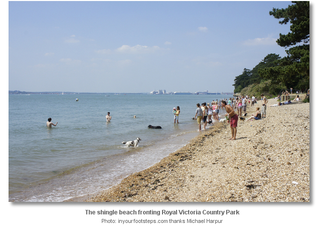
Netley is on the shores of Southampton Water and the home to the Royal Victoria Country Park. The park comprises 200 acres (81 ha) of mature woodland and grassy parkland that is fronted by a small shingle beach. From 1863 until 1966, the site was home to the Royal Victoria Hospital. All that remains of the hospital today is its conspicuous chapel that makes a prominent mark overlooking the waterway.
 The Solent and Isle of Wight coastal description provides approach details. Vessels navigating the six-mile length of Southampton Water should keep a listening watch for Southampton VTS, on VHF Ch 12/16, especially around the docks, and give priority to commercial traffic.
Vessels converging on Netley will find nothing in the way of local hazards by following the marks and staying in reasonable soundings.
 Come straight in from the initial fix maintaining a watchful eye on the soundings. Be careful not to come in too close as 300 metres out from the shoreline it abruptly shallows.
 The clubhouse of Netley Sailing Club will be seen ashore and the best place to anchor is well clear and to the south of the club’s race marks set in the area immediately offshore.
Anchor off in excellent mud holding. Land by tender on the beach alongside the south face of the club’s slip. There is plenty of room on the beach here. 
Be careful to approach the shore at right angles passing around the head of a large steel outflow pipe that enters the water close south of the slip. The pipe runs out perpendicularly from the shore and its entry point is marked by a conspicuous yellow marker with a cross top on the beach and outer head is a starboard perch.

The club slipways permits launch and recovery at most states of tide but on a very low Spring tide a wade through the slime may be required.
Why visit here?
Set on the idyllic grounds of the Royal Victoria Country Park and overlooked by the church of the Royal Victoria Military Hospital, marked Netley Great Dome on the charts, this is a beautiful and useful family boat anchorage.
Royal Victoria Country Park, is the site of the old Royal Victoria Military Hospital, or Netley Hospital. The hospital was built after the Crimean War and was opened in 1863, and the necessity for having a large military hospital showed the scale of the conflict,. It was 435 metres long and had around 1,000 beds. It was Britain's largest military hospital, and received extensive use during the Boer War and the two World Wars. The hospital was fronted by the 175 metres long Netley Pier that was originally built in 1856 and rebuilt in 1865. The pier was used for patients travelling to the military hospital until it was largely made obsolete by a railway spur that served the hospital from 1901. It continued to be used for patients until it became unsafe and had to be demolished in 1955. The main hospital building was finally closed in 1958, and demolished in 1966 after a major fire in 1963. In 1979 it was converted into the country park that it is today.
The Hospital Chapel is all that remains of the Royal Victoria Military Hospital and it is a Heritage Visitor Centre. Tours are available to go the top of the tower and are worth doing for the view over the Solent.
Behind the park by the ruins of Netley Abbey is the village of Netley. The oldest part of Netley retains the feel of a somewhat old-fashioned and quaint village, with some traditional small shops, and rows of colourful terraced cottages. Although the surrounding area has seen some large scale housing developments the village still retains the feel of a small community.
From a sailing perspective Netley is an ideal location to anchor and let the children loose to play. The Park has tarmac walkways, woodland paths, duck pond, tea rooms, barbecue areas, toilets, children’s play areas and a small gauge railway. A shingle beach fronts the park where it is possible to have a swim especially at high water. Entrance to the park is free.
What facilities are available?
There are no facilities apart from the Royal Victoria Country Park's coffee shop and toilets. The Hamble River, entered less than ½ a mile southward, offers almost any conceivable marine service or facility a vessel could require.The back entrance to the park is a 5-10 minute walk from Netley station. Netley railway station is on the main Southampton to Portsmouth line which features hourly services to Southampton and Portsmouth. Bus no.16 goes to Netley Village from Hamble Square. From the village, follow the brown tourist road signs into the park via the main entrance along the coast road. For bus times contact First Bus +44 23 8022 4854.
Any security concerns?
Nerve an issue known to have occurred to a vessel anchored off Netley.With thanks to:
Michael Harpur, s/y Whistler of Southampton. Photography Michael Harpur


This video presents a quick aerial overview of Royal Victoria Country Park
This video presents a longer aerial overview of Royal Victoria Country Park that includes Southampton Water.
A history of the Royal Victoria Military Hospital Netley.
About Netley
Set on the idyllic grounds of the Royal Victoria Country Park and overlooked by the church of the Royal Victoria Military Hospital, marked Netley Great Dome on the charts, this is a beautiful and useful family boat anchorage.
Royal Victoria Country Park, is the site of the old Royal Victoria Military Hospital, or Netley Hospital. The hospital was built after the Crimean War and was opened in 1863, and the necessity for having a large military hospital showed the scale of the conflict,. It was 435 metres long and had around 1,000 beds. It was Britain's largest military hospital, and received extensive use during the Boer War and the two World Wars. The hospital was fronted by the 175 metres long Netley Pier that was originally built in 1856 and rebuilt in 1865. The pier was used for patients travelling to the military hospital until it was largely made obsolete by a railway spur that served the hospital from 1901. It continued to be used for patients until it became unsafe and had to be demolished in 1955. The main hospital building was finally closed in 1958, and demolished in 1966 after a major fire in 1963. In 1979 it was converted into the country park that it is today.
The Hospital Chapel is all that remains of the Royal Victoria Military Hospital and it is a Heritage Visitor Centre. Tours are available to go the top of the tower and are worth doing for the view over the Solent.
Behind the park by the ruins of Netley Abbey is the village of Netley. The oldest part of Netley retains the feel of a somewhat old-fashioned and quaint village, with some traditional small shops, and rows of colourful terraced cottages. Although the surrounding area has seen some large scale housing developments the village still retains the feel of a small community.
From a sailing perspective Netley is an ideal location to anchor and let the children loose to play. The Park has tarmac walkways, woodland paths, duck pond, tea rooms, barbecue areas, toilets, children’s play areas and a small gauge railway. A shingle beach fronts the park where it is possible to have a swim especially at high water. Entrance to the park is free.
Other options in this area
Click the 'Next' and 'Previous' buttons to progress through neighbouring havens in a coastal 'clockwise' or 'anti-clockwise' sequence. Alternatively here are the ten nearest havens available in picture view:
Coastal clockwise:
Kemps Quay - 2.2 miles NNWSaxon Wharf Marina - 2.2 miles NNW
Shamrock Quay - 2.1 miles NNW
Ocean Village Marina - 1.8 miles NW
Town Quay - 2 miles NW
Coastal anti-clockwise:
Hamble Point Marina - 0.8 miles ESEPort Hamble Marina - 0.7 miles E
Mercury Yacht Harbour - 0.9 miles ENE
Elephant Boatyard - 1.2 miles NE
Deacons Marina and Boatyard - 1.3 miles NE
Navigational pictures
These additional images feature in the 'How to get in' section of our detailed view for Netley.


| Detail view | Off |
| Picture view | On |
This video presents a quick aerial overview of Royal Victoria Country Park
This video presents a longer aerial overview of Royal Victoria Country Park that includes Southampton Water.
A history of the Royal Victoria Military Hospital Netley.
Add your review or comment:
Please log in to leave a review of this haven.
Please note eOceanic makes no guarantee of the validity of this information, we have not visited this haven and do not have first-hand experience to qualify the data. Although the contributors are vetted by peer review as practised authorities, they are in no way, whatsoever, responsible for the accuracy of their contributions. It is essential that you thoroughly check the accuracy and suitability for your vessel of any waypoints offered in any context plus the precision of your GPS. Any data provided on this page is entirely used at your own risk and you must read our legal page if you view data on this site. Free to use sea charts courtesy of Navionics.