
_county_cork_ireland_tom allan (3).jpg)
Set behind islands and the mainland, with rocky shoals breaking any seaway, the anchorage offers good protection from all but very strong southerly winds. Approaches to the general area, from the north end of Baltimore Harbour or directly from Long Island Bay, are unmarked, intricate and challenging. All of this requires careful navigation in settled conditions with good visibility.

Keyfacts for Trá Bán
Facilities

Nature


Considerations
Protected sectors

Approaches

Shelter
Last modified
November 19th 2021 Summary
A tolerable location with attentive navigation required for access.Facilities
Nature
Considerations
Position and approaches

Expand to new tab or fullscreen
Haven position
 51° 29.762' N, 009° 25.473' W
This is off the beach where vessels normally anchor
What is the initial fix?
The following River Ilen Entrance Initial Fix will set up a final approach:
 51° 28.575' N, 009° 26.404' W


What are the key points of the approach?
Offshore details are available in southwestern Ireland’s Coastal Overview for Cork Harbour to Mizen Head  . River Ilen directions to the anchorage are covered in the Oldcourt
  description situated upriver from Quarantine Island.
. River Ilen directions to the anchorage are covered in the Oldcourt description situated upriver from Quarantine Island. Not what you need?
Click the 'Next' and 'Previous' buttons to progress through neighbouring havens in a coastal 'clockwise' or 'anti-clockwise' sequence. Below are the ten nearest havens to Trá Bán for your convenience.
Ten nearest havens by straight line charted distance and bearing:
- East Pier - 0.3 nautical miles NE
- Turk Head - 0.5 nautical miles ESE
- Rincolisky Harbour - 0.5 nautical miles N
- Quarantine Island - 0.9 nautical miles E
- Kinish Harbour - 1.2 nautical miles SSE
- Castle Ruins - 1.4 nautical miles SE
- Horseshoe Harbour - 1.7 nautical miles SSE
- Inane Creek - 2 nautical miles ENE
- Baltimore - 2 nautical miles ESE
- Horse Island - 2.3 nautical miles NW
These havens are ordered by straight line charted distance and bearing, and can be reordered by compass direction or coastal sequence:
- East Pier - 0.3 miles NE
- Turk Head - 0.5 miles ESE
- Rincolisky Harbour - 0.5 miles N
- Quarantine Island - 0.9 miles E
- Kinish Harbour - 1.2 miles SSE
- Castle Ruins - 1.4 miles SE
- Horseshoe Harbour - 1.7 miles SSE
- Inane Creek - 2 miles ENE
- Baltimore - 2 miles ESE
- Horse Island - 2.3 miles NW

Chart

What's the story here?
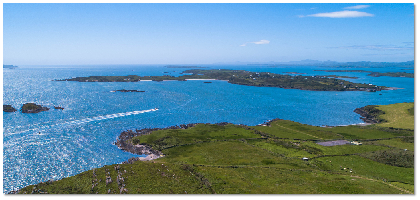 Trá Bán's white sands make it obvious from a distance
Image: Michael Harpur
Heir Island, also known as Hare Island or Inis Uí Drisceoil, is the third largest of the archipelago of islands in Roaringwater Bay and the fourth-largest of Carbery's Hundred Isles, after Sherkin Island, Clear Island and Long Island. Trá Bán is a sandy stretch that faces the entrance to the River Ilen.
 Yachts anchored off northeastern adjacent to Trá Bán
Image: Burke Corbett
Best depths are off the northeastern shoreline where 2 metres LAT can be found about 150 metres out.
How to get in?
Image: Michael Harpur
 Offshore details are available in southwestern Ireland’s Coastal Overview for Cork Harbour to Mizen Head . Seaward approaches and run up The Sound, from Baltimore Harbour, are covered in the Oldcourt River Ilen description as the anchorage lies off of its approach path.
 Approaching the anchorage
Image: Burke Corbett
When abreast of Two Woman’s Rock prepare to break off this track but steer northwest to clear a shallow area with 1.5 metres over it that extends about 400 metres from Two Woman’s Rock. Once clear of this shallow area turn towards the headland that extends to the northeast of the beach and start to sound in. Do not steer to the centre of the beach as there are multiple rocks awash close south of a west bearing line off of the north face of a rock that is always dry and situated off of the beach.
 Anchor under the headland that extends to the northeast of the beach
Image: Michael Harpur
Anchor according to draft in mud and sand that offers excellent holding. Best water will be found keeping about 150 metres off the northeastern shoreline. Land on the beach in the middle of the island or at the East Pier.
Why visit here?
Trá Bán, means 'white beach' in Irish and it perfectly describes the fine sandy beach lapped by idyllic waters.One of several Heir island beaches it is by some margin its best beach sheltered from the prevailing westerly wind. The beach is well used as an anchorage and landing point for leisure craft during the summer months. It is one of Heir Island's many wildlife preserves - see Heir Island (East Pier)
for island information.What facilities are available?
The island has two piers, and a shop whose location is in the main hamlet on the west side of the island, where fresh bread which is made on the island is available. Although the small island does not have a pub, it has holiday rentals, an art gallery, a sailing school, an outdoor activities camp, a permanent restaurant and an occasional restaurant located in the Sailing School. The permanent island restaurant is reputed to be very good and is by prior reservation only.Heir Island is accessible by boat all year round by ferry. The main way to get to the island is via the island ferry that departs from Cunnamore point to the island's main pier 6 times a day, every 2 hours, from 8am to 6pm during the summer. Another ferry services Heir and Sherkin islands from Baltimore & Cunnamore throughout the Summer months of July and August.
Any security concerns?
Never an issue known to have occurred to a boat anchored off Heir Island.With thanks to:
Diarmuid Minihane, Baltimore Harbour Master.

Add your review or comment:
Please log in to leave a review of this haven.
Please note eOceanic makes no guarantee of the validity of this information, we have not visited this haven and do not have first-hand experience to qualify the data. Although the contributors are vetted by peer review as practised authorities, they are in no way, whatsoever, responsible for the accuracy of their contributions. It is essential that you thoroughly check the accuracy and suitability for your vessel of any waypoints offered in any context plus the precision of your GPS. Any data provided on this page is entirely used at your own risk and you must read our legal page if you view data on this site. Free to use sea charts courtesy of Navionics.