
_county_waterford_ireland_John Hughes via CC BY 2 HEADER.jpg)
Ballynacourty (The Pool) is situated on Ireland’s south coast at the start of the channel to Dungarvan Harbour. It is a relatively deep anchoring position in a rural setting adjacent to an old drying pier and hotel.
Situated in the mouth of the bay, but nestled in sheltered channels, it offers a tolerable anchorage in most conditions. However, it is exposed to a good deal of sea at high water during southeasterly winds. Should this occur, proceeding onward to Dungarvan Town Quay would be a natural choice. Navigation is straightforward, night or day and at any stage of the tide, as the entrance channel is well marked by ample closely spaced lit channel markers, which are easily picked up and leave little to confuse.


Keyfacts for Ballynacourty (The Pool)


Last modified
November 19th 2020 Summary* Restrictions apply
A tolerable location with straightforward access.Facilities


Nature


Considerations

Position and approaches

Expand to new tab or fullscreen
Haven position
 52° 5.061' N, 007° 34.482' W
200 metres west of Ballynacourty Pier in the north end of a deep hole known locally as 'The Pool'.
What is the initial fix?
The following Dungarvan Initial Fix will set up a final approach:
 52° 4.500' N, 007° 32.000' W


What are the key points of the approach?
Offshore details are available in southeastern Ireland’s coastal overview for Rosslare Harbour to Cork Harbour  . Seaward approaches, along with the run across the bay, are covered in the Dungarvan Town Quay
  entry.
. Seaward approaches, along with the run across the bay, are covered in the Dungarvan Town Quay entry.Not what you need?
Click the 'Next' and 'Previous' buttons to progress through neighbouring havens in a coastal 'clockwise' or 'anti-clockwise' sequence. Below are the ten nearest havens to Ballynacourty (The Pool) for your convenience.
Ten nearest havens by straight line charted distance and bearing:
- Dungarvan Town Quay - 1.7 nautical miles WNW
- Helvick - 2 nautical miles SSE
- Stradbally Cove - 4.7 nautical miles ENE
- Ardmore Bay - 9.6 nautical miles SSW
- Boatstrand Harbour - 10.5 nautical miles ENE
- Youghal - 12.7 nautical miles SW
- Knockadoon Slip - 16 nautical miles SW
- Port of Waterford - 20.2 nautical miles ENE
- Little Island - 21.2 nautical miles ENE
- Dunmore East - 21.9 nautical miles E
These havens are ordered by straight line charted distance and bearing, and can be reordered by compass direction or coastal sequence:
- Dungarvan Town Quay - 1.7 miles WNW
- Helvick - 2 miles SSE
- Stradbally Cove - 4.7 miles ENE
- Ardmore Bay - 9.6 miles SSW
- Boatstrand Harbour - 10.5 miles ENE
- Youghal - 12.7 miles SW
- Knockadoon Slip - 16 miles SW
- Port of Waterford - 20.2 miles ENE
- Little Island - 21.2 miles ENE
- Dunmore East - 21.9 miles E


What's the story here?
 Ballynacourty
Image: Michael Harpur
Ballinacourty, officially Ballynacourty, overlooks Dungarvan Bay from a rural part of the shore. It is fronted by a drying 19th-century pier and boathouse, with a hotel and golf course adjacent.
 Ballynacourty Pier, small beach and slipway
Image: Michael Harpur
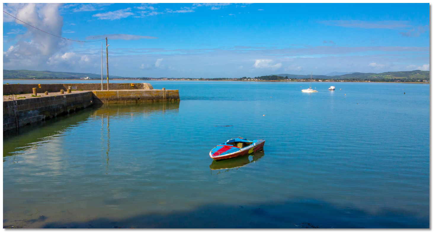
The Pool is a deepwater part of the channel leading across the bay to Dungarvan Harbour. It can be found abreast and about 200 metres to the west of Ballynacourty Pier. The Pool is relatively deep (it has from 2.3 to 3.5 metres of water at LWS), steep and surrounded by shallow water. Three or four leisure vessels may lie here in perfect safety, sheltered by the Deadman Sand.
How to get in?
 The Pool lies about 200 metres to the west of Ballynacourty Pier
Image: Michael Harpur
 Use the directions provided for Dungarvan Town Quay for approaches to Ballynacourty and the pool.
 By night the lighthouse on Ballynacourty Point is sectored and the channel markers are lit. Street lights on the pier and the hotel's lights make the location just as obvious.
 Ballynacourty Pier as seen from The Pool
Image: Burke Corbett
Carefully sound out the position of The Pool. The Pool is relatively deep, steep and surrounded by shallow water, so sound it out carefully. It is important to get a good feel for its extent so that the scope of the chain does not allow the vessel to swing out over the surrounding shallow ground. The area has excellent sand and shale holding. At high water land by tender at the pier, which dries out beyond its head, or at the inner slip.
Why visit here?
Ballinacourty, officially Ballynacourty, takes its name from the Irish Baile na Cúirte, meaning ‘town of the court/mansion’ or ‘Mansion Village’. The ‘Mansion’ was the residence of the Osbornes, to whom this property passed from Roger Dalton in the early part of the 17th century. The limestone masonry of Ballynacourty’s pier has served since 1832
Image: Michael Harpur
Ballynacourty’s central feature has to be its elegant pier, which dates back to 1832 and is a reminder of the maritime heritage that traditionally supported the village’s economy. The pier is made up of high-quality limestone masonry, which has stood the test of time.
 Original bollard
Image: Michael Harpur
Novel features by today’s standards, such as the cut-stone mooring bollards and stone cobbling, are as serviceable now as when the pier was first built. It presents an attractive focal point to the village hotel and golf course behind.
 Ballynacourty Point Lighthouse
Image: Burke Corbett
A mile to the southeast, set back from the road in its own grounds, is the picturesque Ballynacourty Point Lighthouse. Built as part of the Irish Lights Building Programme, the light was first established in July 1858. It was subsequently converted to acetylene operation in 1929 and electrified during February 1964. Throughout these changes it retained its original form and character and, together with its lighthouse keeper's house, makes for an appealing point of focus to Ballynacourty Point. It can be accessed via a long, narrow lane between holes 6 and 7 of the golf course.
 Ballynacourty Point Lighthouse and its grounds
Image: John Hughes via CC BY 2.0
The championship parkland golf course dates back to 1939 and was originally a 9-hole course. It has recently been extended to 18 holes and offers mature tree-lined fairways with panoramic views of Dungarvan Bay and the Comeragh mountains. Needless to say, the Gold Coast Hotel located alongside provides a welcome rest to tired and thirsty sailors. So, despite its rural locale, Ballincourty has plenty of interest to occupy a shore visit.
 Ballynacourty Pier with the tide on the rise and Dungarvan in the background
Image: John Hughes via CC BY 2.0
From a boating point of view, this is an ideal holding anchorage for boats awaiting a tide to get to the jetty off the Boat Club in Dungarvan Harbour, and is much used as such by local boatmen. But the haven itself serves as a secure, easily accessed stopover for a good night’s sleep while making passage along the coast. It likewise provides a good place to sit out an adverse coastal tidal stream without having to go too far off track to slip into the next tide.
What facilities are available?
Land at the pier or slip, where a tap can be found. The hotel offers food and drink. Basic shopping is to be had in the village, while Dungarvan Harbour provides better provisioning opportunities.Any security concerns?
Never an issue known to have occurred to a vessel anchored in The Pool.With thanks to:
Burke Corbett, Gusserane, New Ross, Co. Wexford.About Ballynacourty (The Pool)
Ballinacourty, officially Ballynacourty, takes its name from the Irish Baile na Cúirte, meaning ‘town of the court/mansion’ or ‘Mansion Village’. The ‘Mansion’ was the residence of the Osbornes, to whom this property passed from Roger Dalton in the early part of the 17th century.
The limestone masonry of Ballynacourty’s pier has served since 1832Image: Michael Harpur
Ballynacourty’s central feature has to be its elegant pier, which dates back to 1832 and is a reminder of the maritime heritage that traditionally supported the village’s economy. The pier is made up of high-quality limestone masonry, which has stood the test of time.
Original bollardImage: Michael Harpur
Novel features by today’s standards, such as the cut-stone mooring bollards and stone cobbling, are as serviceable now as when the pier was first built. It presents an attractive focal point to the village hotel and golf course behind.
Ballynacourty Point LighthouseImage: Burke Corbett
A mile to the southeast, set back from the road in its own grounds, is the picturesque Ballynacourty Point Lighthouse. Built as part of the Irish Lights Building Programme, the light was first established in July 1858. It was subsequently converted to acetylene operation in 1929 and electrified during February 1964. Throughout these changes it retained its original form and character and, together with its lighthouse keeper's house, makes for an appealing point of focus to Ballynacourty Point. It can be accessed via a long, narrow lane between holes 6 and 7 of the golf course.
Ballynacourty Point Lighthouse and its groundsImage: John Hughes via CC BY 2.0
The championship parkland golf course dates back to 1939 and was originally a 9-hole course. It has recently been extended to 18 holes and offers mature tree-lined fairways with panoramic views of Dungarvan Bay and the Comeragh mountains. Needless to say, the Gold Coast Hotel located alongside provides a welcome rest to tired and thirsty sailors. So, despite its rural locale, Ballincourty has plenty of interest to occupy a shore visit.
Ballynacourty Pier with the tide on the rise and Dungarvan in the backgroundImage: John Hughes via CC BY 2.0
From a boating point of view, this is an ideal holding anchorage for boats awaiting a tide to get to the jetty off the Boat Club in Dungarvan Harbour, and is much used as such by local boatmen. But the haven itself serves as a secure, easily accessed stopover for a good night’s sleep while making passage along the coast. It likewise provides a good place to sit out an adverse coastal tidal stream without having to go too far off track to slip into the next tide.
Other options in this area
Click the 'Next' and 'Previous' buttons to progress through neighbouring havens in a coastal 'clockwise' or 'anti-clockwise' sequence. Alternatively here are the ten nearest havens available in picture view:
Coastal clockwise:
Dungarvan Town Quay - 1 miles WNWHelvick - 1.3 miles SSE
Ardmore Bay - 6 miles SSW
Youghal - 7.9 miles SW
Knockadoon Slip - 9.9 miles SW
Coastal anti-clockwise:
Stradbally Cove - 2.9 miles ENEBoatstrand Harbour - 6.5 miles ENE
Dunmore East - 13.6 miles E
Creadan Head - 14.7 miles ENE
Passage East - 14.9 miles ENE
Navigational pictures
These additional images feature in the 'How to get in' section of our detailed view for Ballynacourty (The Pool).


| Detail view | Off |
| Picture view | On |
Add your review or comment:
Please log in to leave a review of this haven.
Please note eOceanic makes no guarantee of the validity of this information, we have not visited this haven and do not have first-hand experience to qualify the data. Although the contributors are vetted by peer review as practised authorities, they are in no way, whatsoever, responsible for the accuracy of their contributions. It is essential that you thoroughly check the accuracy and suitability for your vessel of any waypoints offered in any context plus the precision of your GPS. Any data provided on this page is entirely used at your own risk and you must read our legal page if you view data on this site. Free to use sea charts courtesy of Navionics.