

Ballygalley Bay is situated on the northeast coast of Ireland about twenty-two miles south of Fair Head and three miles to the north of Larne. The bay offers an anchorage off a small holiday village tht is out of the run of the currents.
Ballygalley Bay offers good protection west through south to southeast but is entirely exposed to any northerly quadrant conditions. With the absence of any immediate offshore dangers, or any tidal restrictions, daylight access to the bay is straightforward.


Keyfacts for Ballygalley Bay


Last modified
December 19th 2022 Summary* Restrictions apply
A good location with straightforward access.Facilities


Nature


Considerations


Position and approaches

Expand to new tab or fullscreen
Haven position
 54° 54.066' N, 005° 51.450' W
This is the anchoring area in sand off the head of Ballygalley Bay.
What is the initial fix?
The following Ballygalley Bay Initial Fix will set up a final approach:
 54° 54.467' N, 005° 51.146' W


What are the key points of the approach?
Offshore details are available in northeast Ireland’s Coastal Overview for Malin Head to Strangford Lough  .
.
.- Vessels approaching from the east or southeast can choose to pass around either side of the well-marked Hunter Rock and The Maidens.
- Locate Ballygally Castle, 0.6-mile west-southwest of the headland at the head of the bay, and track in on a bearing 210° T of the castle.
Not what you need?
Click the 'Next' and 'Previous' buttons to progress through neighbouring havens in a coastal 'clockwise' or 'anti-clockwise' sequence. Below are the ten nearest havens to Ballygalley Bay for your convenience.
Ten nearest havens by straight line charted distance and bearing:
- Ferris Bay - 3.8 nautical miles SE
- Brown’s Bay - 4.1 nautical miles SE
- Larne Harbour - 4.5 nautical miles SE
- Glenarm - 5.2 nautical miles NW
- Ballydowan - 5.4 nautical miles SE
- Portmuck - 5.5 nautical miles SE
- Magheramorne Point - 5.7 nautical miles SSE
- Mill Bay - 5.8 nautical miles SE
- Carnlough - 7.1 nautical miles NW
- Whitehead - 10.4 nautical miles SSE
These havens are ordered by straight line charted distance and bearing, and can be reordered by compass direction or coastal sequence:
- Ferris Bay - 3.8 miles SE
- Brown’s Bay - 4.1 miles SE
- Larne Harbour - 4.5 miles SE
- Glenarm - 5.2 miles NW
- Ballydowan - 5.4 miles SE
- Portmuck - 5.5 miles SE
- Magheramorne Point - 5.7 miles SSE
- Mill Bay - 5.8 miles SE
- Carnlough - 7.1 miles NW
- Whitehead - 10.4 miles SSE


What's the story here?
 Ballygalley Bay
Image: Michael Harpur
Ballygalley Bay is a north-facing bay situated to the northwest of Ballygalley Head. A small village set at the head of the bay with a well-preserved Scottish baronial castle, conjoined today with a hotel, overlooking the sea from its northwest corner. The small village has a population of fewer than 1000 people and is largely a holiday resort for visitors who come to enjoy the bay's ¼ long sandy beach.
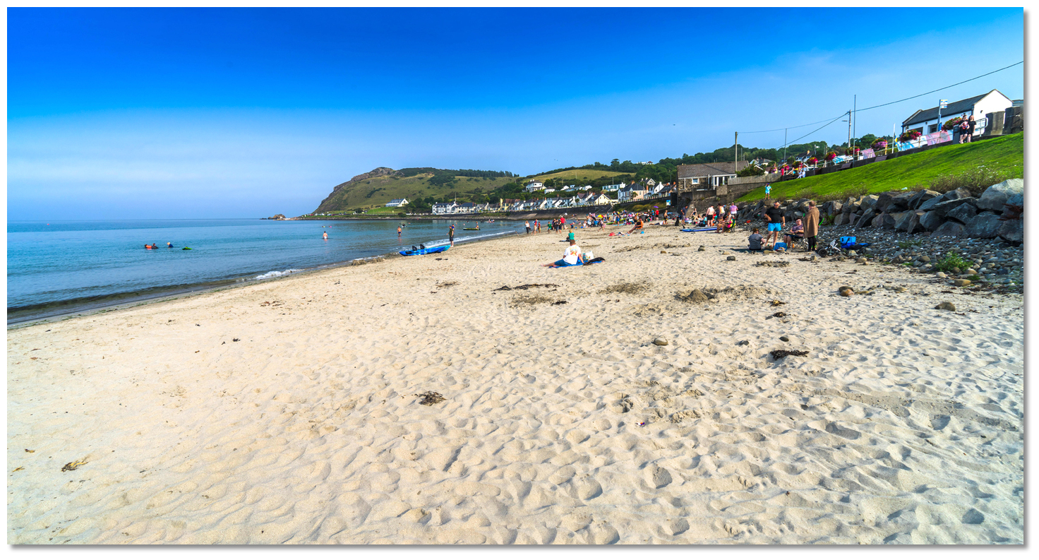 The bay's long sandy beach and its views are the village's principal attraction
Image: Michael Harpur
The large clean bay gradually shoals to the head and offers a good anchorage with offshore winds.
How to get in?
 Ballygalley Head
Image: Tourism NI
 Offshore details for vessels are available in northeast Ireland’s coastal overview for Malin Head to Strangford Lough . Ballygalley Head is a prominent and unmistakable feature of the coastline with its 89 metres high round knuckle shape, with a steep cliff and base fringed by craggy basaltic rocks. The 383 metres high Robin Young Hill, the highest of several peaks in this vicinity, rises 2.7 miles west-southwest of Ballygalley Head. On closer approaches, the ruins of the ancient Cairncastle are situated on a rock at the base of the cliffs which form the head. A new tower house can be seen in the village 0.6 miles west by southwest of the headland at the head of a Ballygally Bay.
 Vessels approaching from the east and northeast will need to circumvent the well-marked offshore rock clusters of Hunter Rock, the Maidens, and Highland Rock situated 3 to 5 miles out to sea, east round to northeast, of Ballygalley Head.
 The Maidens Towers
Image: Charles W. Bash vi CC BY SA 4.0
The Maidens are located about 4 miles northeast of Ballygalley Head, a distance of 4½ miles from Larne and consist of two groups of rocks separated by a navigable passage. The rocks are steep-to all around.
The north cluster consists of three small rocks that are arranged in the form of a triangle. The western Russell’s Rock is 1.00 metres above high water, the eastern Highlandman Rock covers one hour before high water, and the southern, or Allen Rock, covers at high water. Rocky ledges extend both to the northward and southeast of the Allen rock whilst the others are steep-to. The northeastmost Highlandman (Highland Rock) is marked by a beacon. They are covered by the red
sector (142°-182°) of the east maiden auxiliary light.
Highlandman (Highland Rock) – unlit 1.5 metres position: 54°57.286'N, 005°43.935'W
 East Maiden with The Saddle and the Sheafing Rock in the backdrop
 Image: David Maxfield via CC BY-SA 3.0
The southern section consists of two clusters of rocks called the East and West Maiden that are separated from each other by a deep and wide sound. East Maiden on which stands a lighthouse, with a white tower and black band, and West Maiden on which is a tall, disused, tower of a disused lighthouse and other prominent buildings.
East Maiden Lighthouse - Fl (3) 20s 29m 24M position: 54° 55.748’N, 005° 43.709’W
 The inactive West Maiden Lighthouse
Image: David Maxfield via CC BY-SA 3.0
West Maiden lighthouse was taken out of service in 1903. Other rocks in the southern group, lying within a ½ mile south of the East maiden lighthouse are; The Bushes, The Griddle, The Saddle and Sheafing Rock. Expect most ships to head directly to Scotland by passing south of the Maidens. Occasionally vessels, that are awaiting berthing space in Larne, do pass to the north and then inside the Maidens.
 South Hunter
Image: Commissioners of Irish Lights
Between the Maidens and Larne, there is the singular Hunter Rock that has 0.8 metres of water over it. Hunter Rock is a well-marked shoal with North and South Cardinal Light buoys and it is the only danger here. It lies 2½ miles northeast of the entrance or 036° T from Ferris Point, the entrance’s eastern point. Similar to the Maidens, Ballygally Bay may be approached on either side of Hunter Rock.
North Hunter - VQ position: 54° 53.046’N, 005 45.114’W
South Hunter - VQ (6) + LFl 10s position: 54° 52.691’N, 005 45.284’W
Vessels approaching from the south will find an inshore passage from Larne Head, a distance of 3½ miles, between the mainland and Hunter and the Maidens, steep-to and clear of off-lying dangers. Good depths will be found close in with 400 metres from the shore clearing all dangers.
Vessels converging on Ballygalley Bay from all other directions will find no outlying hazards. North of Hangman and Maiden Rocks, where the Antrim Mountains push out almost vertically to the coast, is clear of outlying dangers 400 metres beyond the cliffs.
Image: Michael Harpur
 From the Ballygalley Bay initial fix Ballygally Castle will be seen standing on the rocks at the base of the cliffs 0.6-mile west-southwest of the headland at the head of the bay. Track in on the tan-coloured Ballygalley Castle, overlooking the bay from the northwest end of the village, on a bearing 210° T.
.jpg) Track in on bearing 210° of the tan coloured Ballygalley Castle (right)
Track in on bearing 210° of the tan coloured Ballygalley Castle (right)Image: Michael Harpur
Anchor according to draft and conditions over a sandy bottom that shoals gradually to the head of the bay. 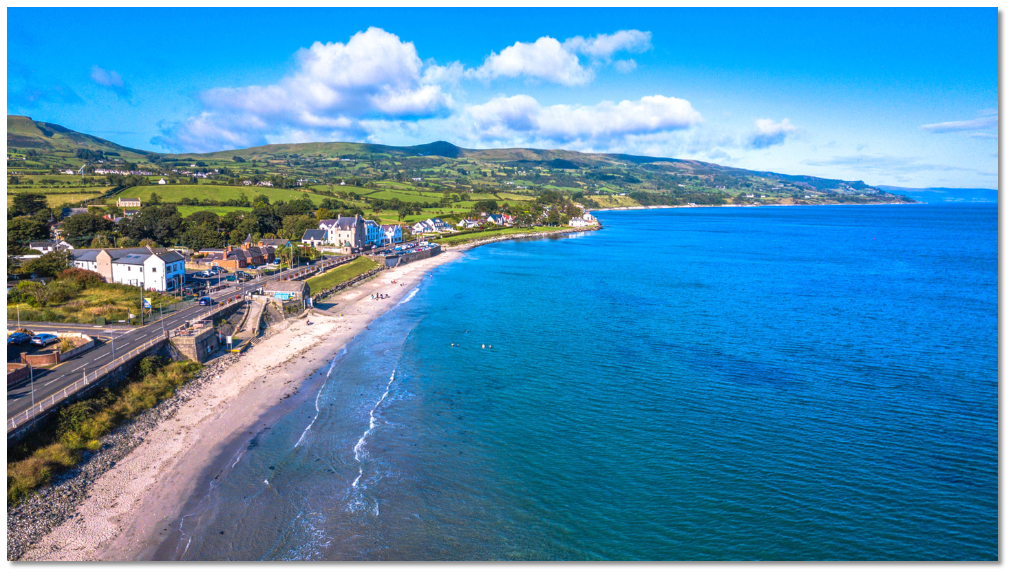 The boathouse and the beach as seen from the southeast
Image: Tourism NI
Land on the beach at the head of the bay or at the slipway situated under the headland on the southern shore of the bay.
Why visit here?
Ballygalley Bay, also spelt Ballygally, derives its name from the Irish words ' Baile Uí Cheallaigh'. Pronounced 'bala gehlee this is believed to mean 'O'Kelly’s Homestead' but the origin of the personal name 'O'Kelly' is uncertain and very rare in the area today. Ulster Museum model of a Neolithic farmhouse
Image: Notafly via CC ASA 3.0
Ballygalley’s history of inhabitation, akin to this entire stretch of coast, goes way back to very ancient times. A 1990s archaeological excavation of the bay’s low ground, about 500 metres from the shoreline, unearthed the remains of a number of Neolithic houses. The historically important site produced a large number of artefacts, including pottery, worked flints, stone axes and a considerable quantity of carbonized cereal grains, mostly Einkorn wheat, as well as cattle bone. It is the latter that indicated that the houses were the dwellings of a farming community. The finds also suggested that the Ballygalley Neolithic community were not fishing, fowling or gathering shellfish. Beads that they used for personal adornment were of stone rather than marine shells. Moreover, the raw materials they used imply local and long-distance maritime connections.
 Dugouts typical of the Neolithic period
Image: Public Domain
Flint nodules may have been gathered from the local beach, while porcellanite was brought from Tievebulliagh and by boat from Rathlin Island. Stone axes were found that came from Great Langdale, in Cumbria in northeast England and from Cornwall. Many pieces of pitchstone would have been brought to Ballygalley from the island of Arran, in the Firth of Clyde. So, it seems likely that Ballygalley may have been some type of redistribution place or trading harbour, a feasting house or a ritual, public structure. It is clear that in addition to farming Ballygalley was part of a system of exchange in materials across the north Irish Sea also certainly involving flint axes and other artefacts and porcellanite axes. So Ballygalley was in this sense, a place on the Neolithic seaways as well as a farming community.
 Cairncastle sometimes referred to as O'Halloran’s Castle
Image: Aiwha via CC BY SA 2.00
The bay's oldest castle is the stone ruin on the rock beyond Ballygally Head. Called Cairncastle, sometimes referred to as O'Halloran’s Castle, it was originally built by the Anglo-Norman Knight Duncan Fitzgilbert who was given lands here in the early 13th century. The local Parish of Cairncastle is named after this castle on the rocks. The bay's signature castle however is its overlooking Ballygally Castle. It was built in 1625 by James Shaw, from Greenock in Scotland, and his wife Isabella Brisbane. Shaw originally came here in 1606 at the start of the 'Plantation of Ulster' and rented this land from the 'Earl of Antrim'. It was almost twenty years later before he commenced the fine structure of Ballygally Castle which would be heavily influenced by Scottish design. Its high walls, steep roof, dormer windows and corner turrets featuring corbelled cylindrical tourelles with conical roofs on top, are all baronial design statements. Shaw added personalised touches inside with an inscription over the main entrance door leading to the tower that read ‘1625 Godis Providens is my Inheritans’. Above it, he placed the joint coat of arms of the Shaw and Brisbane families, with the letters J.S and I.B.
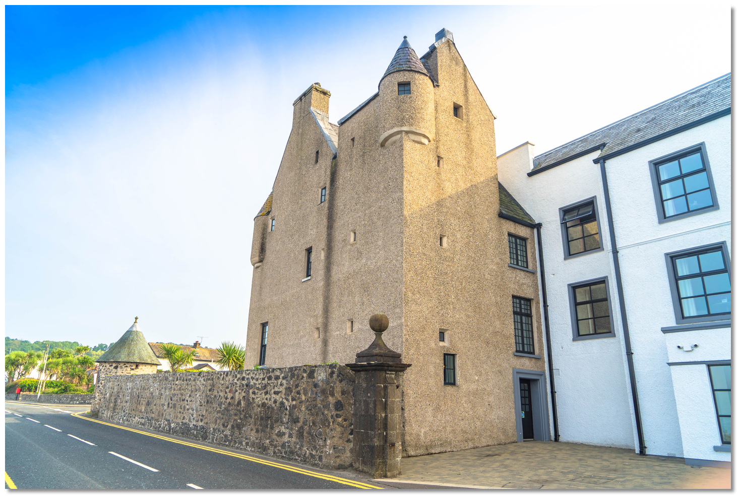 The 'classic' early 17th-century Scottish baronial style Ballygally Castle
Image: Michael Harpur
Though featuring a flourish of eye-catching design features the castle was just as capable of defending itself. It had walls five feet thick, including loopholes for muskets, and an open stream running through the outer hall provided water in the event of a siege. During the rebellion of 1641, it served as a place of refuge for the Protestants. The castle came under attack from the Irish garrison at Glenarm several times during the rebellion, but each assault was unsuccessful. It continued to be a point of retreat during the following two centuries and was used as a fortress as late as the 18th Century. Because the castle provided sanctuary for such large numbers of people and has seen off so many large-scale attacks in its time, it is now believed that the original building was more extensive than the current remains of the ancient Castle.
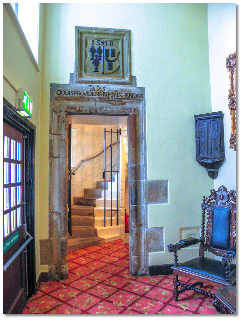 The main entrance door with its inscription above
Image: Kenneth Allen via CC BY SA 2.0
Today the 17th Century castle sits in the middle of the village that spreads out around its feet. Situated at the junction with the road to Cairncastle it is now conjoined with a 4-star hotel with a renovated bar and restaurant. It is reputed to be the oldest occupied building in Ireland and one of Ireland’s best-preserved Scottish baronial-style plantation houses. The castle also has a reputation for being haunted by ghosts.
The most active of which is the former resident, Lady Isobel Shaw the wife of Lord James Shaw, who has a habit of knocking on the doors of the rooms and disappearing. Legend has it Lord Shaw wanted a son to be his heir, and this was his chief desire for Lady Shaw. When she delivered him an heir he snatched her away and locked her up in a room at the top of the castle. From there it is said she fell to her death whilst trying to escape. Another theory has it that Lord Shaw himself threw her to her death or he paid someone to do it. Whichever the case the ghost of Lady Isobella is said to be friendly and is regularly seen wandering around the old castle, perhaps in search of her beloved son. Madame Nixon is another ghost who lived in the hotel in the 19th century and can be heard walking around the hotel in her silk dress. The hotel is proud of its resident ghosts. It dedicates the small room in the corner turret of the older part of the castle, known as 'The Ghost Room', to the spirits and do not rent it out to guests.
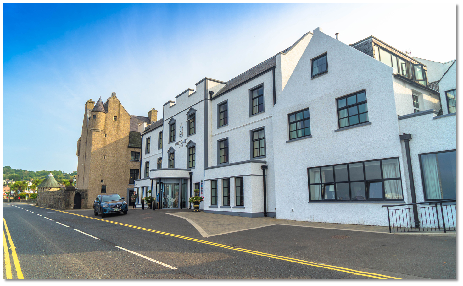 The castle is now part of the Ballygally Castle Hotel
Image: Michael Harpur
Today the small village of Ballygalley may often be overlooked as a destination. But anyone setting down on its 300-metre-long sandy beach will see it has plenty to offer. To the north, up towards the Antrim coast, is the dramatic wall of Antrim with its headlands. To the east, the open sea expands, and beyond it, the low outline of the Scottish coast can be visible. To the south is the distinctive Ballygalley Head with its roadside crag, a village landmark and a favourite with climbers. Inland to the west is the village’s landmark features such as Scawt Hill and Sallagh Braes. And of course, immediately ashore is its castle, standing proudly in all of its 17-century Planter sobriety it looks more like a centrepiece of Scotland than Ireland.
 The castle commands to this day the bay and the river that exits into it
Image: Michael Harpur
There is a lot to take in and the village offers its visitors a range of activities. It has a host of wonderful walks, and golfers will find the welcoming 18 Hole Cairndhu Golf Club, on top of Ballygalley Head to the south of the village, more than attractive. Divers will find the wreck of an 1889 gunboat, SS Thrush, a big attraction. Though the Ballygally Castle building is more impressive from the outside than in, a potential drink with Lady Isobella in the Ballygally Castle Hotel dungeon bar has to be tempting.
 Ballygalley Bay's beach and its vistas are it's principal draws today
Image: Tourism NI
From a boating point of view, Ballygalley Bay is the first anchorage and settlement to the north of Larne. It provides a place to step out of the run of the current along this coastline, with good protection and holding to the prevailing winds. This is a considerable advantage in this area making it a good place to have a lunch stop, await a favourable tide or even have an overnight stay in good conditions.
What facilities are available?
Ballygalley now has a new two-storey community centre (funded by the Big Lottery, Larne Borough Council and NER) which includes a Spar shop with some Post Office facilities at ground level and a Community Hall on the first floor.Any security concerns?
Never a problem known to have occurred to a vessel anchored in Ballygalley Bay.With thanks to:
Terry Crawford, local boatman of many decades. Photography with thanks to Kenneth Allen, Mat Tuck, Michael Clarke, Albert Bridge, Richard Webb, Sandra White, Sue Adair, Dave Napier and Phil Sangwell.Aerial views of Ballygalley Bay
Cairncastle sometimes referred to as O’Halloran’s Castle
About Ballygalley Bay
Ballygalley Bay, also spelt Ballygally, derives its name from the Irish words ' Baile Uí Cheallaigh'. Pronounced 'bala gehlee this is believed to mean 'O'Kelly’s Homestead' but the origin of the personal name 'O'Kelly' is uncertain and very rare in the area today.
Ulster Museum model of a Neolithic farmhouseImage: Notafly via CC ASA 3.0
Ballygalley’s history of inhabitation, akin to this entire stretch of coast, goes way back to very ancient times. A 1990s archaeological excavation of the bay’s low ground, about 500 metres from the shoreline, unearthed the remains of a number of Neolithic houses. The historically important site produced a large number of artefacts, including pottery, worked flints, stone axes and a considerable quantity of carbonized cereal grains, mostly Einkorn wheat, as well as cattle bone. It is the latter that indicated that the houses were the dwellings of a farming community. The finds also suggested that the Ballygalley Neolithic community were not fishing, fowling or gathering shellfish. Beads that they used for personal adornment were of stone rather than marine shells. Moreover, the raw materials they used imply local and long-distance maritime connections.
Dugouts typical of the Neolithic periodImage: Public Domain
Flint nodules may have been gathered from the local beach, while porcellanite was brought from Tievebulliagh and by boat from Rathlin Island. Stone axes were found that came from Great Langdale, in Cumbria in northeast England and from Cornwall. Many pieces of pitchstone would have been brought to Ballygalley from the island of Arran, in the Firth of Clyde. So, it seems likely that Ballygalley may have been some type of redistribution place or trading harbour, a feasting house or a ritual, public structure. It is clear that in addition to farming Ballygalley was part of a system of exchange in materials across the north Irish Sea also certainly involving flint axes and other artefacts and porcellanite axes. So Ballygalley was in this sense, a place on the Neolithic seaways as well as a farming community.
Cairncastle sometimes referred to as O'Halloran’s CastleImage: Aiwha via CC BY SA 2.00
The bay's oldest castle is the stone ruin on the rock beyond Ballygally Head. Called Cairncastle, sometimes referred to as O'Halloran’s Castle, it was originally built by the Anglo-Norman Knight Duncan Fitzgilbert who was given lands here in the early 13th century. The local Parish of Cairncastle is named after this castle on the rocks. The bay's signature castle however is its overlooking Ballygally Castle. It was built in 1625 by James Shaw, from Greenock in Scotland, and his wife Isabella Brisbane. Shaw originally came here in 1606 at the start of the 'Plantation of Ulster' and rented this land from the 'Earl of Antrim'. It was almost twenty years later before he commenced the fine structure of Ballygally Castle which would be heavily influenced by Scottish design. Its high walls, steep roof, dormer windows and corner turrets featuring corbelled cylindrical tourelles with conical roofs on top, are all baronial design statements. Shaw added personalised touches inside with an inscription over the main entrance door leading to the tower that read ‘1625 Godis Providens is my Inheritans’. Above it, he placed the joint coat of arms of the Shaw and Brisbane families, with the letters J.S and I.B.
The 'classic' early 17th-century Scottish baronial style Ballygally CastleImage: Michael Harpur
Though featuring a flourish of eye-catching design features the castle was just as capable of defending itself. It had walls five feet thick, including loopholes for muskets, and an open stream running through the outer hall provided water in the event of a siege. During the rebellion of 1641, it served as a place of refuge for the Protestants. The castle came under attack from the Irish garrison at Glenarm several times during the rebellion, but each assault was unsuccessful. It continued to be a point of retreat during the following two centuries and was used as a fortress as late as the 18th Century. Because the castle provided sanctuary for such large numbers of people and has seen off so many large-scale attacks in its time, it is now believed that the original building was more extensive than the current remains of the ancient Castle.
The main entrance door with its inscription aboveImage: Kenneth Allen via CC BY SA 2.0
Today the 17th Century castle sits in the middle of the village that spreads out around its feet. Situated at the junction with the road to Cairncastle it is now conjoined with a 4-star hotel with a renovated bar and restaurant. It is reputed to be the oldest occupied building in Ireland and one of Ireland’s best-preserved Scottish baronial-style plantation houses. The castle also has a reputation for being haunted by ghosts.
The most active of which is the former resident, Lady Isobel Shaw the wife of Lord James Shaw, who has a habit of knocking on the doors of the rooms and disappearing. Legend has it Lord Shaw wanted a son to be his heir, and this was his chief desire for Lady Shaw. When she delivered him an heir he snatched her away and locked her up in a room at the top of the castle. From there it is said she fell to her death whilst trying to escape. Another theory has it that Lord Shaw himself threw her to her death or he paid someone to do it. Whichever the case the ghost of Lady Isobella is said to be friendly and is regularly seen wandering around the old castle, perhaps in search of her beloved son. Madame Nixon is another ghost who lived in the hotel in the 19th century and can be heard walking around the hotel in her silk dress. The hotel is proud of its resident ghosts. It dedicates the small room in the corner turret of the older part of the castle, known as 'The Ghost Room', to the spirits and do not rent it out to guests.
The castle is now part of the Ballygally Castle HotelImage: Michael Harpur
Today the small village of Ballygalley may often be overlooked as a destination. But anyone setting down on its 300-metre-long sandy beach will see it has plenty to offer. To the north, up towards the Antrim coast, is the dramatic wall of Antrim with its headlands. To the east, the open sea expands, and beyond it, the low outline of the Scottish coast can be visible. To the south is the distinctive Ballygalley Head with its roadside crag, a village landmark and a favourite with climbers. Inland to the west is the village’s landmark features such as Scawt Hill and Sallagh Braes. And of course, immediately ashore is its castle, standing proudly in all of its 17-century Planter sobriety it looks more like a centrepiece of Scotland than Ireland.
The castle commands to this day the bay and the river that exits into itImage: Michael Harpur
There is a lot to take in and the village offers its visitors a range of activities. It has a host of wonderful walks, and golfers will find the welcoming 18 Hole Cairndhu Golf Club, on top of Ballygalley Head to the south of the village, more than attractive. Divers will find the wreck of an 1889 gunboat, SS Thrush, a big attraction. Though the Ballygally Castle building is more impressive from the outside than in, a potential drink with Lady Isobella in the Ballygally Castle Hotel dungeon bar has to be tempting.
Ballygalley Bay's beach and its vistas are it's principal draws todayImage: Tourism NI
From a boating point of view, Ballygalley Bay is the first anchorage and settlement to the north of Larne. It provides a place to step out of the run of the current along this coastline, with good protection and holding to the prevailing winds. This is a considerable advantage in this area making it a good place to have a lunch stop, await a favourable tide or even have an overnight stay in good conditions.
Other options in this area
Click the 'Next' and 'Previous' buttons to progress through neighbouring havens in a coastal 'clockwise' or 'anti-clockwise' sequence. Alternatively here are the ten nearest havens available in picture view:
Coastal clockwise:
Magheramorne Point - 3.5 miles SSEMill Bay - 3.6 miles SE
Ballydowan - 3.4 miles SE
Larne Harbour - 2.8 miles SE
Ferris Bay - 2.4 miles SE
Coastal anti-clockwise:
Glenarm - 3.2 miles NWCarnlough - 4.4 miles NW
Red Bay Pier (Glenariff Pier) - 7.4 miles NW
Cushendall - 7.7 miles NNW
Cushendun - 9.2 miles NNW
Navigational pictures
These additional images feature in the 'How to get in' section of our detailed view for Ballygalley Bay.


| Detail view | Off |
| Picture view | On |
Aerial views of Ballygalley Bay
Cairncastle sometimes referred to as O’Halloran’s Castle
Add your review or comment:
Please log in to leave a review of this haven.
Please note eOceanic makes no guarantee of the validity of this information, we have not visited this haven and do not have first-hand experience to qualify the data. Although the contributors are vetted by peer review as practised authorities, they are in no way, whatsoever, responsible for the accuracy of their contributions. It is essential that you thoroughly check the accuracy and suitability for your vessel of any waypoints offered in any context plus the precision of your GPS. Any data provided on this page is entirely used at your own risk and you must read our legal page if you view data on this site. Free to use sea charts courtesy of Navionics.