

Set within the estuaries’ channels it offers good protection in most conditions. However it is exposed to a large body of water from the north and, at high water, around to the east where in strong winds it becomes uncomfortable. Chichester Harbour's channels are well marked making access straightforward in most conditions, day or night and at most stages of the tide.

Keyfacts for Pilsey Island
Facilities

Nature


Considerations

Protected sectors

Approaches

Shelter
Last modified
July 17th 2018 Summary
A good location with straightforward access.Facilities
Nature
Considerations
HM  +44 1243 512301
  Ch.14 [Chichester Harbour Patrol]
+44 1243 512301 Ch.14 [Chichester Harbour Patrol] Position and approaches

Expand to new tab or fullscreen
Haven position
 50° 48.063' N, 000° 54.335' W
This is in the channell to the east of Pilsey Island


What are the key points of the approach?
Offshore details are available in the westbound  or eastbound sequenced 'Selsey Bill to Start Point' coastal description. Use the Itchenor
  entry for the approaches to Chichester Harbour and directions for Chichester Channel.
or eastbound sequenced 'Selsey Bill to Start Point' coastal description. Use the Itchenor entry for the approaches to Chichester Harbour and directions for Chichester Channel.Not what you need?
Click the 'Next' and 'Previous' buttons to progress through neighbouring havens in a coastal 'clockwise' or 'anti-clockwise' sequence. Below are the ten nearest havens to Pilsey Island for your convenience.
Ten nearest havens by straight line charted distance and bearing:
- East Head - 0.7 nautical miles SSW
- Chalkdock Point - 1.2 nautical miles ENE
- Itchenor - 1.5 nautical miles ENE
- Sparkes Marina - 1.7 nautical miles WSW
- Thornham Marina - 2.2 nautical miles N
- Bosham - 2.3 nautical miles NE
- Hayling Yacht Company - 2.4 nautical miles W
- Emsworth Yacht Harbour - 2.7 nautical miles NNW
- Birdham Pool Marina - 2.9 nautical miles E
- Emsworth - 2.9 nautical miles NNW
These havens are ordered by straight line charted distance and bearing, and can be reordered by compass direction or coastal sequence:
- East Head - 0.7 miles SSW
- Chalkdock Point - 1.2 miles ENE
- Itchenor - 1.5 miles ENE
- Sparkes Marina - 1.7 miles WSW
- Thornham Marina - 2.2 miles N
- Bosham - 2.3 miles NE
- Hayling Yacht Company - 2.4 miles W
- Emsworth Yacht Harbour - 2.7 miles NNW
- Birdham Pool Marina - 2.9 miles E
- Emsworth - 2.9 miles NNW

Chart

How to get in?
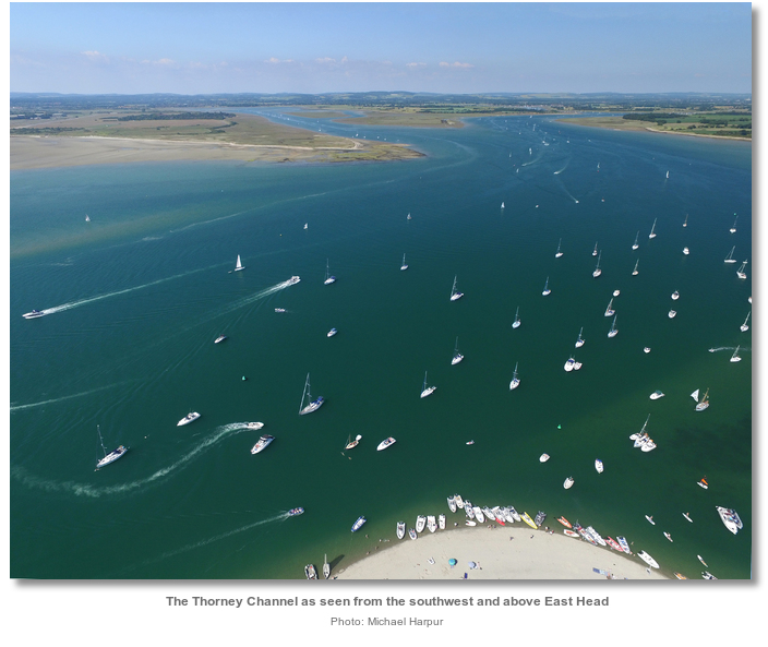
Pilsey Island sits in the northeast section of Chichester Harbour. It is located about a mile and a half up the Chichester Channel, that stretches north-westward up through the harbour, to where it branches off in the Thorney Channel. The anchoring area is about quarter of a mile within the entrance to the Thorney Channel. It is one of the harbour’s three recognised anchorages and is as convenient, albeit much quieter, than the very popular East Head.

Pilsey Island along with the other anchorages of East Head
and Chalkdock Point on the approaches to Itchenor, are all accessed from Chichester Channel that is detailed, along with approaches to Chichester Harbour, in the Itchenor entry. Chichester Harbour's sheltered and drying channels are almost entirely occupied by private moorings. Vessels should not anchor in or near established mooring grounds for fear of fouling existing ground tackle. Vessels anchored in Chichester Harbour should not be left unattended for long periods of time and must display a black ball along with an anchor light at night. Swimming off the boat is dangerous here because of the strong tides within the channel.

 The Thorney Channel is entered from the Chichester Channel close west of the Camber Light-beacon south cardinal pile, Q (6) + LFl 15s, that stands 500 metres southeast of Pilsey Island. When close the Camber Light-beacon the substantial piles within the channel make the fairway plain.
 The first port ‘Pilsey’ pile Fl [2] R 10s off Pilsey Island and a corresponding starboard pole on the opposite bank will be clearly seen 300 metres north by northwest. Pass between these marks and prepare to anchor in the deep, steep-to Thorney Channel off the eastern shore of Pilsey Island.
 Anchor on the west side of the channel anywhere from the first 'Pilsey' port pile marker and a second port pile located about 500 metres northward, up channel and to the northeast of Pilsey Island.
 The second port pile has the corresponding ‘Thorney’ starboard-hand beacon, Fl G 5s, opposite and it marks a gap between broken piles east of Longmere Point, Thorney Island’s south-eastern point.
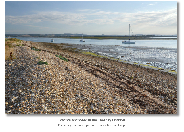
The anchorage has excellent sand and mud holding. Land on the steeply shelving beach by tender but do not leave the foreshore as the island is a wildlife reserve.

Why visit here?
Pilsey Island is a nature reserve that the Royal Society for the Protection of Birds has managed since 1985, from the Ministry of Defence.
Unusually both Pilsey Islands and Thorney Island, immediately north, are not technically islands any more. Since the reclamation of the tidal mudflats in 1870 Thorney Island, so named because of its profusion of hawthorn bushes, it effectively became a peninsula that juts out into Chichester Harbour. It is now only separated from the mainland by a narrow channel called the Great Deep. The old piles at the north end of the anchoring area are the remains of a much more ambitious scheme to build a huge embankment from the bottom of Thorney Island across to Chidham. The current Thorney channel would have been drained and converted to arable land, and a substantial arm of the harbour would have been lost. Precisely when this happened is unknown but the sturdy wooden stakes straddling the mudbanks, seen today at low tide, formed the basis of the embankment. During the construction a gale and high seas carried away the bank and the plan was aborted.
In the last several decades nature has made its own connections to Pilsey Island. Sand has been naturally deposited between it and Thorney island creating a causeway or bridge. The small ‘V’ shaped Pilsey Island comprises an area of about a hectare that encompasses a wide range of coastal environments. These include intertidal sandflats and mudflats, saltmarsh, sand dunes, bare and vegetated shingle and a white beach on its eastern side. This very diverse environment plays host to an impressive variety of unusual plants, including sea lavender, samphire & bladderwort, and marram.

Today the island acts as one of the few natural sanctuaries within the harbour area. It is permissible to land on the reserves eastern beach. Visiting sailors can walk and have a picnic on the foreshore but should not go beyond the MHW line as the bird’s habitats within the island are vulnerable to disturbance. The locality can be readily enjoyed from here with rewarding views over Pilsey Island, Thorney Channel and East Head to the south.
Those intending to visit Thorney Island should land at the stage above Thorney Island Sailing Club. A British Army military base occupies the southern part of Thorney Island, south of Great Deep, but it is permissible to walk around island’s coastal public footpath, part of the Sussex Border Path, that encircles it.

From a sailing perspective this is a very quiet anchorage that never gets crowded or overrun like its near neighbour East Head. It also provides very good shelter from strong winds from west round to northwest to which East Head is exposed.
What facilities are available?
Pilsey Island has no facilities.Any security concerns?
Never an issue known to have occurred to a vessel anchored off Pilsey Island.With thanks to:
Phil Walker Deputy Harbour Master Chichester Harbour. Photography by Michael Harpur.


Add your review or comment:
Please log in to leave a review of this haven.
Please note eOceanic makes no guarantee of the validity of this information, we have not visited this haven and do not have first-hand experience to qualify the data. Although the contributors are vetted by peer review as practised authorities, they are in no way, whatsoever, responsible for the accuracy of their contributions. It is essential that you thoroughly check the accuracy and suitability for your vessel of any waypoints offered in any context plus the precision of your GPS. Any data provided on this page is entirely used at your own risk and you must read our legal page if you view data on this site. Free to use sea charts courtesy of Navionics.