
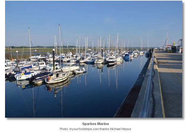
Sparkes Marina is located immediately within Chichester Harbour which is situated on the south coast of England. It is a small but very convenient marina.
Tucked inside the large natural harbour and up its own dredged entrance channel the marina offers complete protection from all conditions. Although the harbour is entered over a moderately deep sand bar, and between sand banks, it is very well marked and straightforward. The marina is one of only two marinas in Chichester Harbour that are accessible at all states of the tide.

Keyfacts for Sparkes Marina
Last modified
July 17th 2018 Summary
A completely protected location with straightforward access.Facilities


Nature


Considerations


Position and approaches
Expand to new tab or fullscreen
Haven position
 50° 47.202' N, 000° 56.586' W
This is the north most point of the marina wall near the fuel berth.
What are the key points of the approach?
Offshore details are available in the westbound  or eastbound
  sequenced 'Selsey Bill to Start Point' coastal description. Use the Itchenor
  entry for the approaches to Chichester Harbour, directions for Chichester Channel.
 or eastbound
  sequenced 'Selsey Bill to Start Point' coastal description. Use the Itchenor
  entry for the approaches to Chichester Harbour, directions for Chichester Channel.
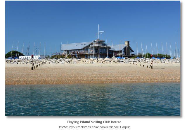
- After passing Hayling Island Sailing Club round Black Point and the club pontoon jetty to enter the dredged channel.
- Follow the two yellow ‘X’ leading marks on a bearing of 277° T for the first length then turn south and follow the closely spaced substantial port steel piles into the marina.
- Berth as directed by the marina office.
Not what you need?
Click the 'Next' and 'Previous' buttons to progress through neighbouring havens in a coastal 'clockwise' or 'anti-clockwise' sequence. Below are the ten nearest havens to Sparkes Marina for your convenience.
Ten nearest havens by straight line charted distance and bearing:
- East Head - 1.2 nautical miles ENE
- Hayling Yacht Company - 1.4 nautical miles NW
- Pilsey Island - 1.7 nautical miles ENE
- Chalkdock Point - 2.9 nautical miles ENE
- Northney Marina - 3 nautical miles NNW
- Langstone Harbour - 3.2 nautical miles WNW
- Thornham Marina - 3.2 nautical miles NNE
- Itchenor - 3.2 nautical miles ENE
- Emsworth Yacht Harbour - 3.4 nautical miles N
- Emsworth - 3.5 nautical miles N
These havens are ordered by straight line charted distance and bearing, and can be reordered by compass direction or coastal sequence:
- East Head - 1.2 miles ENE
- Hayling Yacht Company - 1.4 miles NW
- Pilsey Island - 1.7 miles ENE
- Chalkdock Point - 2.9 miles ENE
- Northney Marina - 3 miles NNW
- Langstone Harbour - 3.2 miles WNW
- Thornham Marina - 3.2 miles NNE
- Itchenor - 3.2 miles ENE
- Emsworth Yacht Harbour - 3.4 miles N
- Emsworth - 3.5 miles N
How to get in?

Sparkes Marina is located in the southwest corner of Chichester Harbour, immediately within the entrance and on the south-eastern tip of Hayling Island. It is at the end of its own dredged channel that makes it one of the two marinas in the harbour that are accessible at all states of the tide. The marina however is relatively small and tight when compared to others in the harbour. It caters for 140 berths with some being reserved for visitors. Though small it can nevertheless accommodate vessels of up to 20 metres in up to 2.5 metres when berths are available. Use the
 entry for approaches to Chichester Harbour and directions from the entrance.
Sparkes Marina is in a popular location with many of its berths subject to size or draft restrictions. As such it can easily get overwhelmed. It is therefore advisable to make berthing arrangements in advance by contacting the marina on VHF Ch. 80 or P: +44 2392 463572

 Proceed up Chichester entrance channel until the Hayling Island Sailing Club is abeam. The dredged approach channel to Sparkes Marina will be found about 150 metres north of the clubhouse leading off west by north-westward. It is entered from the junction of the entrance channel with the Emsworth and Chichester channels located to the south of the Fisher Channel Mark.
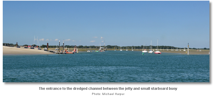
It entrance is located immediately around Black Point and off the head of the Hayling Island Sailing Club’s pontoon jetty. The northern side is marked by an unlit east cardinal beacon, with a tide gauge, and a small green starboard buoy situated close south of the beacon.

From the junction south of the Fisher cardinal approach the channels entrance steering westward passing in midway between the jetty and starboard buoy. The helmsman should keep a keen eye out for crosscurrents.
Once inside the channel follow its first length by aligning two yellow ‘X’ St. Andrews crosses leading marks on a bearing of 277° T in line. The day-glow marks are located on the mud flats about 500 metres or so westward of the entrance and are clearly visible against the trees in the backdrop. The fairway is nevertheless made readily apparent by its lines of moorings on both sides. A floating pontoon and pile moorings will be seen on its inner southern flank.

After the pile moorings the channel divides into the Mengeham Channel, forking off to the northwest, and the last of the Sparkes Marina channel, turning to the south where the marina will be clearly seen at this point. The marina's channel is then marked by closely spaced and substantial steel port piles with red can top marks and some smaller starboard hand posts with green conical heads. These show the final length of pathway into the marina.

 Berth as directed by the marina office. Visitor berths are usually alongside the outer pontoon on the east side of the marina wall.
Why visit here?
Sparkes Marina is owned and operated by Marina Development Limited (MDL) based in Hamble Hampshire. The company owns and manages eighteen coastal marinas and boatyards in England which includes another marina in Chichester Harbour at Northney. It has other facilities in France, Italy and Spain and the company provides its berth holders with freedom to roam between their extensive ranges of facilities when space is available. Sparkes Marina is the most seaward berth on Hayling Island.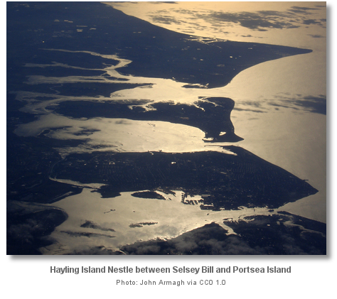
The Island derives its name from the conjunction of the name Haegel with inga and ég. This name means ‘settlement of, or followers of, or island of the family of a man called Haegel’. Haegel was a Saxon chieftain who claimed the island as his principle area of settlement after the Romans left. The name Haegel very slightly softened down through the centuries and was first recorded as Heglingaigce in 956, Halingei in the 1086 Doomsaday Book, Hailinges in about 1140, to its present ‘Hayling’.
The island’s inhabitation however goes back to Neolithic times though there is little evidence of permanent settlements here. The British Museum has a polished axe-head and two or three arrowheads that were found on the island and dated to 8,000 to 2,500 BC. Hoards of ‘palstaves’, a type of early bronze axe, have been found at North Hayling and at Gable Head. These are believed to have been ritualistic burial placements during the later Bronze Age. An iron-age shrine discovered in the north of Hayling Island was later developed into a Roman temple in the first century; the continuance of worship on the site reflected the religious importance bestowed to islands during pagan times. On the south eastern side of the Island is the commanding Tourner Bury earthwork hill fort that is considered to fall across these periods. Unfortunately, the Saxons and Vikings destroyed all the Roman buildings and left very little of any significance for historians themselves.
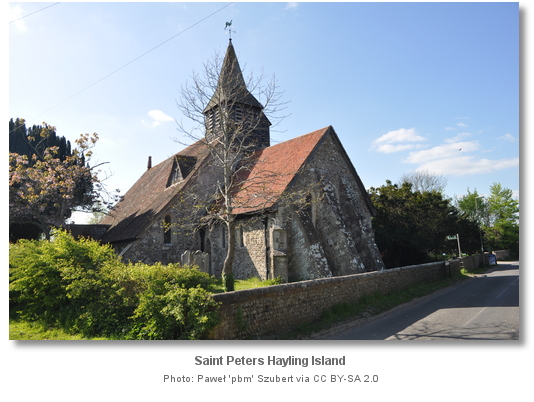
Not so lucky however was Hayling Island’s lost priory that fell victim to some of the island’s most challenging times. It is believed to have been located in the ancient Norman moated site where the 1777 Manor House stands today. The priory church, along with much of the southern edge of the Island and Selsey Bill, was destroyed by flooding in the 13th or 14th century. After the disaster St. Mary's Church, constructed on the Island’s highest point, became the central church on Hayling. The flooding was followed by the ‘Black Death’, the bubonic plague pandemic, that killed as much as half the population of England. It was also a time of national emergency when the island needed to be defended against attacks by the French.
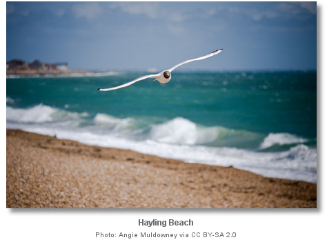
The islands combination of sail and surf remarkably led to windsurfing being invented here in the nineteen fifties. Peter Chilvers, who as a young boy on Hayling Island, assembled his first board combined with a sail in 1958. In 1982 in a landmark design case the British courts recognised ‘prior art’ by judging Peter Chilvers incorporated all the elements of the modern windsurfer based on film footage he presented from the time. The courts found that later innovations were "merely an obvious extension" and upheld the defendant's claim. Today Chilvers’s sport is very popular on the south beach along with kitesurfing of which Hayling is the south’s new hotspot. The island set a Guinness World Record for the longest line of kite surfers and holds the record for the longest line of stand-up paddle boarders.

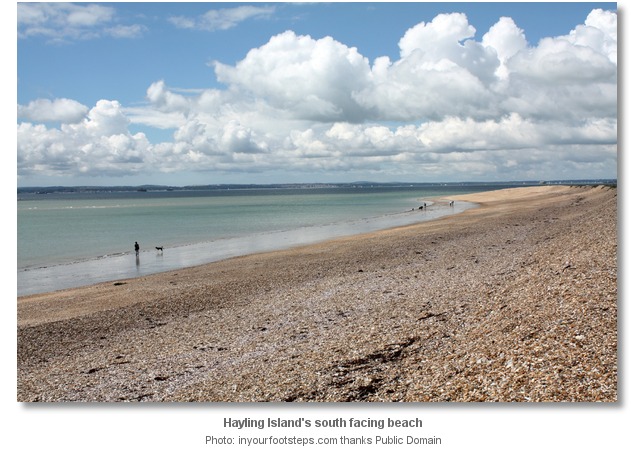
Today the island remains a popular holiday resort with many facilities and four miles of Blue Flag beach at Beachlands. The natural beach was predominantly sandy but in recent years it has been mechanically topped with shingle dredged from the bed of the Solent in an effort to reduce beach erosion and reduce the potential to flood low lying land. Backed by grassy dunes, Victorian beach huts, the unspoilt nature of Hayling Island waterfront sets it aside from many other larger resorts. Children will enjoy the Hayling Seaside Railway that runs from Beachlands and along the beach to Eastoke Corner which is replete with all the typical amenities of a family seaside resort.

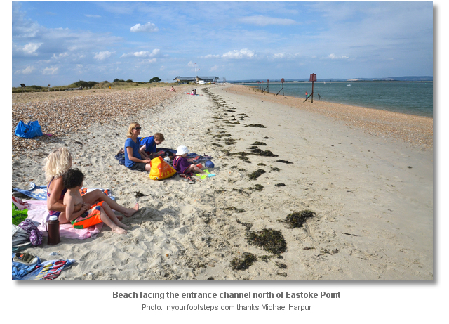
From a sailing perspective Sparkes Marina offers vessels a very convenient all-tide berth on the threshold of Chichester Harbour. It is the ideal point of arrival to land or refuel before exploring the dozen or so widely varying locations within this Area of Outstanding Natural Beauty. It offers a family boat two wonderful beaches, with the beach overlooking the entrance between Hayling Island Sailing Club and Eastoke Point being an easy walk.
What facilities are available?
The pontoons provide power and water. All domestic requirements up to and including WiFi can be found within the marina area. A coin operated launderette is open 24 hours a day. Diesel and unleaded petrol are available at the fuel bay, located on the port side pontoon immediately within the entrance. The marina provides general waste disposal, and full recycling facilities. Arrangements can be made for the disposal of waste oil. The popular on-site Piranha Bar & Restaurant overlooks the marina.A travel hoist can lift vessels weighing up to 40 tons and there is hard standing for up to 200 boats ashore. There are good facilities ashore for boat owners wanting to carry out boat repairs or maintenance. The area features many marine related tradesmen that specialise in engineering, outboard engines, glass fibre repairs, rigging, sails and covers, marine carpentry, electrical, boat management and valeting.
The only way to and from Hayling Island from land is over Hayling Bridge which gets congested in the summer. The nearest railway station to Hayling Island is Havant, just onto the mainland off Hayling Island and about a mile from the bridge. Alternatively, Portsmouth and Southsea offers alternate railway stations, used for connections to Bristol (Temple Meads) and Cardiff.
Any security concerns?
The Marina is manned 24 Hours. Access to the marina and its facilities is controlled by key fob. CCTV cameras are located throughout the marina, including car parks and shoreside.With thanks to:
Phil Walker Deputy Harbour Master Chichester Harbour. Photography by Michael Harpur, Mike Owens, John Armagh, Angie Muldowney, Alan Ford and Paweł 'pbm' Szubert.



About Sparkes Marina
Sparkes Marina is owned and operated by Marina Development Limited (MDL) based in Hamble Hampshire. The company owns and manages eighteen coastal marinas and boatyards in England which includes another marina in Chichester Harbour at Northney. It has other facilities in France, Italy and Spain and the company provides its berth holders with freedom to roam between their extensive ranges of facilities when space is available. Sparkes Marina is the most seaward berth on Hayling Island.

The Island derives its name from the conjunction of the name Haegel with inga and ég. This name means ‘settlement of, or followers of, or island of the family of a man called Haegel’. Haegel was a Saxon chieftain who claimed the island as his principle area of settlement after the Romans left. The name Haegel very slightly softened down through the centuries and was first recorded as Heglingaigce in 956, Halingei in the 1086 Doomsaday Book, Hailinges in about 1140, to its present ‘Hayling’.
The island’s inhabitation however goes back to Neolithic times though there is little evidence of permanent settlements here. The British Museum has a polished axe-head and two or three arrowheads that were found on the island and dated to 8,000 to 2,500 BC. Hoards of ‘palstaves’, a type of early bronze axe, have been found at North Hayling and at Gable Head. These are believed to have been ritualistic burial placements during the later Bronze Age. An iron-age shrine discovered in the north of Hayling Island was later developed into a Roman temple in the first century; the continuance of worship on the site reflected the religious importance bestowed to islands during pagan times. On the south eastern side of the Island is the commanding Tourner Bury earthwork hill fort that is considered to fall across these periods. Unfortunately, the Saxons and Vikings destroyed all the Roman buildings and left very little of any significance for historians themselves.

Not so lucky however was Hayling Island’s lost priory that fell victim to some of the island’s most challenging times. It is believed to have been located in the ancient Norman moated site where the 1777 Manor House stands today. The priory church, along with much of the southern edge of the Island and Selsey Bill, was destroyed by flooding in the 13th or 14th century. After the disaster St. Mary's Church, constructed on the Island’s highest point, became the central church on Hayling. The flooding was followed by the ‘Black Death’, the bubonic plague pandemic, that killed as much as half the population of England. It was also a time of national emergency when the island needed to be defended against attacks by the French.

The islands combination of sail and surf remarkably led to windsurfing being invented here in the nineteen fifties. Peter Chilvers, who as a young boy on Hayling Island, assembled his first board combined with a sail in 1958. In 1982 in a landmark design case the British courts recognised ‘prior art’ by judging Peter Chilvers incorporated all the elements of the modern windsurfer based on film footage he presented from the time. The courts found that later innovations were "merely an obvious extension" and upheld the defendant's claim. Today Chilvers’s sport is very popular on the south beach along with kitesurfing of which Hayling is the south’s new hotspot. The island set a Guinness World Record for the longest line of kite surfers and holds the record for the longest line of stand-up paddle boarders.

Today the island remains a popular holiday resort with many facilities and four miles of Blue Flag beach at Beachlands. The natural beach was predominantly sandy but in recent years it has been mechanically topped with shingle dredged from the bed of the Solent in an effort to reduce beach erosion and reduce the potential to flood low lying land. Backed by grassy dunes, Victorian beach huts, the unspoilt nature of Hayling Island waterfront sets it aside from many other larger resorts. Children will enjoy the Hayling Seaside Railway that runs from Beachlands and along the beach to Eastoke Corner which is replete with all the typical amenities of a family seaside resort.

From a sailing perspective Sparkes Marina offers vessels a very convenient all-tide berth on the threshold of Chichester Harbour. It is the ideal point of arrival to land or refuel before exploring the dozen or so widely varying locations within this Area of Outstanding Natural Beauty. It offers a family boat two wonderful beaches, with the beach overlooking the entrance between Hayling Island Sailing Club and Eastoke Point being an easy walk.
Other options in this area
Click the 'Next' and 'Previous' buttons to progress through neighbouring havens in a coastal 'clockwise' or 'anti-clockwise' sequence. Alternatively here are the ten nearest havens available in picture view:
Coastal clockwise:
Langstone Harbour - 2 miles WNWSouthsea Marina - 2.2 miles W
Gunwharf Quays Marina - 3.9 miles W
Port Solent Marina - 4.3 miles WNW
WicorMarine Yacht Haven - 5.2 miles WNW
Coastal anti-clockwise:
Hayling Yacht Company - 0.9 miles NWNorthney Marina - 1.8 miles NNW
Emsworth - 2.1 miles N
Emsworth Yacht Harbour - 2.1 miles N
Pilsey Island - 1 miles ENE
Navigational pictures
These additional images feature in the 'How to get in' section of our detailed view for Sparkes Marina.


| Detail view | Off |
| Picture view | On |
Add your review or comment:
Please log in to leave a review of this haven.
Please note eOceanic makes no guarantee of the validity of this information, we have not visited this haven and do not have first-hand experience to qualify the data. Although the contributors are vetted by peer review as practised authorities, they are in no way, whatsoever, responsible for the accuracy of their contributions. It is essential that you thoroughly check the accuracy and suitability for your vessel of any waypoints offered in any context plus the precision of your GPS. Any data provided on this page is entirely used at your own risk and you must read our legal page if you view data on this site. Free to use sea charts courtesy of Navionics.


 +44 23 9246 3572
 sparkes@mdlmarinas.co.uk
 mdlmarinas.co.uk/
 Ch.80 [Sparkes Marina]


