
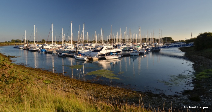
Northney Marina is located in the northwest corner of Chichester Harbour which is situated on the south coast of England. It is a large modern marina in a rural setting on the north side of Hayling island.
Set deep within the recess of the large natural harbour the marina offers complete protection from all conditions. Although the harbour is entered over a moderately deep sand bar, and between sand banks, it is very well marked and straightforward. The marina is one of only two marinas in Chichester Harbour that are accessible for most vessels at all states of the tide, night or day.


Keyfacts for Northney Marina


Last modified
March 9th 2023 Summary
A completely protected location with straightforward access.Facilities


Nature


Considerations


 +44 23 9246 6321
 northney@mdlmarinas.co.uk
 Ch.80 [Northney Marina]
Position and approaches

Expand to new tab or fullscreen
Haven position
 50° 50.044' N, 000° 57.918' W
This is the starboard side of the marina's entrance.



What are the key points of the approach?
Offshore details are available in the westbound  or eastbound sequenced 'Selsey Bill to Start Point' coastal description. Use the Itchenor
  entry for the approaches to Chichester Harbour.
or eastbound sequenced 'Selsey Bill to Start Point' coastal description. Use the Itchenor entry for the approaches to Chichester Harbour.- Within Chichester Harbour's entrance take the Emsworth Channel by passing the Fisher south cardinal marker to starboard.
- Continue north for 2¼ miles to the Emsworth south cardinal beacon then branch of into Sweare Deep.
- Follow Sweare Deep for little under a mile passing north around Hayling Island to the marina's entrance.
Not what you need?
Click the 'Next' and 'Previous' buttons to progress through neighbouring havens in a coastal 'clockwise' or 'anti-clockwise' sequence. Below are the ten nearest havens to Northney Marina for your convenience.
Ten nearest havens by straight line charted distance and bearing:
- Emsworth - 1.2 nautical miles ENE
- Emsworth Yacht Harbour - 1.3 nautical miles ENE
- Hayling Yacht Company - 1.8 nautical miles S
- Thornham Marina - 1.9 nautical miles E
- Langstone Harbour - 2.6 nautical miles SW
- Sparkes Marina - 3 nautical miles SSE
- Pilsey Island - 3 nautical miles SE
- East Head - 3.3 nautical miles SE
- Southsea Marina - 3.6 nautical miles SW
- Chalkdock Point - 3.7 nautical miles ESE
These havens are ordered by straight line charted distance and bearing, and can be reordered by compass direction or coastal sequence:
- Emsworth - 1.2 miles ENE
- Emsworth Yacht Harbour - 1.3 miles ENE
- Hayling Yacht Company - 1.8 miles S
- Thornham Marina - 1.9 miles E
- Langstone Harbour - 2.6 miles SW
- Sparkes Marina - 3 miles SSE
- Pilsey Island - 3 miles SE
- East Head - 3.3 miles SE
- Southsea Marina - 3.6 miles SW
- Chalkdock Point - 3.7 miles ESE


How to get in?

Northney Marina is located in the northwest corner of Chichester Harbour, 3½ miles within the entrance and on the north side of Hayling Island. It is accessed via the deep Eastney and the moderately deep Sweare Deep channels that makes it one of Chichester Harbour’s two marinas that are accessible to most vessels at all states of the tide. The marina has 228 berths and can accommodate yachts up to 24 metres in length and 1.8 metres. Use the Itchenor
entry for approaches to Chichester Harbour and directions from the entrance.The marina holds no specific visitor berths but does accommodate visiting yachts in the berths of resident holders that are away. As such it is therefore advisable to make berthing arrangements in advance by contacting the marina on VHF Ch. 80 or P: +44 9246 6321
 Northney Marina is located about 3½ miles from within the entrance and is accessed through the Emsworth Channel and thence through Sweare Deep.
Proceed up Chichester Harbour’s entrance channel towards the Fisher south cardinal mark situated at the head of the channel – it is located 400 metres northward when Hayling Island Sailing Club draws abeam. This cardinal marks the junction of where the entrance channel divides into the harbour’s two main arms of the Emsworth and Chichester channels. Here the Emsworth Channel continues northward and the Chichester Channel branches off to the east.
Enter the Emsworth Channel by passing: to port, of the small craft moorings situated north of Black Point and the entrance to Sparkes Marina, and to starboard, of the Fisher Channel Mark south cardinal; the NW Pilsey and N Pilsey buoys mark the southwestern end of the drying Pilsey Sands.
From its entrance the Emsworth Channel runs north by northwest for 2¼ miles to the Emsworth south cardinal beacon, Q6 + L Fl 15s. At this point the channel forks with Sweare Deep that leads to Northney Marina. The Emsworth Channel is wide, has a charted depth of at least 2.7 metres in the fairway and is well marked and lit to the beacon. Currents in the channel can however attain speeds of 2 knots.

Half a mile northward of Fisher south cardinal mark is the Mill Rythe port red buoy situated off Hayling Island side on the channel. The Mill Rythe buoy marks the southern side of the entrance to a drying channel that branches off north-westward to the Hayling Yacht Company.
After Mill Rythe the Emsworth Channel is free of moorings. It is marked by red piles with can top marks on the Hayling Island side, green piles with conical top marks on the Pilsey Sands to Thorney Island, and then onward to the Emsworth south cardinal beacon.

At the Emsworth south cardinal beacon the channel divides. The Emsworth Channel continues north by northeast for a ½ mile to Emsworth's
floating pontoon. After this it leads to the town quay and marina, entered over a sill, a further ½ mile above, but it increasingly narrows and becomes shallow until it eventually dries. 
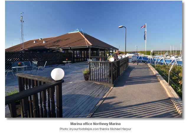
Sweare Deep forks off 45° to port and north-westward. It passes around Hayling Island’s north-eastern corner for just under a mile to where the entrance channel to Northney Marina opens. The marina's roof and forest of masts will be visible at this point. Enter Sweare Deep by passing the Emsworth south cardinal beacon to starboard and a lit port pile mark to port Fl(2)R 10s 8m.

Sweare Deep at least 10 metres wide is well-marked with red and green half-tide piles on its drying banks plus three substantial lit port pile beacons within the channel. The first of these port piles is opposite the Emsworth south cardinal beacon. All of these piles flash at 10s intervals.

The channel has at least 2 metres up to the second port pile marker located half a mile northwest Fl(3)R. Between this and the final mark Fl(4)R, that is situated on the entrance channel to Northney, and the entrance channel itself, expect 1 to 1.5 metres chart datum. At low water best depths are to be found by following the moorings on the north side of the channel as opposed to tracking a straight line between the port hand beacons.

At the Northney port hand pile beacon turn sharp to south into the marina’s entrance channel that is marked by red and green perches. Enter the marina via a short channel dredged to 1 metre chart datum.
 It is essential to call on VHF Ch. 80 or by mobile for a vacant berth before arriving. Upon arrival berth as directed by the marina office.
Low air draught vessels may pass between Chichester and Langstone harbours at high water. This may be achieved by continuing westward past the entrance to Northney Marina and pass under Hayling road bridge connecting the island to the mainland. The bridge has an airdraft of 1.3 metres and the passage underneath it is 9 metres wide. Beyond it there is the ruins of the old railway connection with a well-marked pass.

Once under the bridge continue through North Lake on the Langstone side to connect with the head of the Langstone Channel. Although dry at LWS North Lake has a depth of 3.7 in at MHWS.
Why visit here?
Northney Marina is owned and operated by Marina Development Limited (MDL) based in Hamble Hampshire. The company owns and manages eighteen coastal marinas and boatyards in England which includes Sparkes Marina at the entrance to Chichester Harbour. It has other facilities in France, Italy and Spain and the company provides its berth holders with freedom to roam between their extensive range of facilities without berthing fees when space is available.The settlement of North Hayling was first documented as Heglingaigaen' in 956, and in 1256 as Northeneye from which the current name descends. The northern part of Hayling Island is the richest in terms of human inhabitation. One of Hailing’s most significant archaeological monuments, the remains of the Hayling Island Roman temple, were excavated in Touncil Field, mid-way between North Hayling village and the Havant Road. The excavations also indicated Saxon settlement activity on the site. Northney’ evidence of human occupation however dates back to at least the Bronze Age. For this area was the site of the important ‘Wadeway’ that has provided access to the Island for countless millennia.

The ‘Wadeway’ was a raised trackway that was exposed three hours either side of low water. It offered pedestrians, carts and horse riders a pathway from Langstone Village to a point on the Northney shoreline close west of where the marina is sited today. This three-quarter mile long track served the island as early as the Bronze Age. A piece of timber with an ancient axe cut found at the Hayling end of the ‘Wadeway’ was carbon dated to be 1,000 years BC. This provided an indication of just how early this route was established and the ‘Wadeway’ continued to service the island until as late as 1924. In that year a deep water channel called ‘New Cut’ was dredged through the ancient raised trackway to enable the barges of the ‘Portsmouth to Arundel Canal’ touched upon in the
entry. The ‘Wadeway’ was likewise obsoleted that year by the island’s first wooden bridge. Eventually, a toll bridge was built, and then came the railway with its own bridge situated close west of the road bridge. 
Despite its through-traffic Northney stayed rural with a significant concentration of early farmsteads, particularly in the 17th century, that reflected its good agricultural soils and sheltered position. Much of the land was farmed under an open field system and became enclosed by the 1870s. The area was predominantly arable with orchards around Northney and today remains comparatively little changed by 20th century development.

What has remained constant for Northney, and the harbour area as a whole, from as early as the Bronze Age is salt making by the process of evaporating seawater. Situated on the sheltered north-western shore Northney was one of the largest in the region. The activity continued on the island until the late 19th century when these systems were obsoleted by mined salt sources particularly from the salt mines of Cheshire. It is the legacy of the salterns that has created Northney Marina. For Northney Marina is built into the original footprint of what was the Northney saltern. Around the marina one does not have to look far for tangible evidence of these systems through the survival of some of the banks. Small areas of salt marshes still exist on the mudflats around the harbour today.

From a sailing perspective Northney is one of the two all-tide-access marina’s available to most visiting vessels. The very modern marina has all up-to-date facilities in a secluded location, with much of the island’s history tangible via a short walk from the pontoons. The meeting point of Langstone Harbour and Chichester Harbour is generally taken to be the position of the present road bridge, the only bridge crossing to the island, which is about 15 minutes’ walk from the marina. Large sections of the old railway bridge can be seen today close west of the present road bridge which replaced the original wooden bridge in 1956. The ancient ‘Wadeway’ is still visible today particularly at low tide. It can be seen extending between the Royal Oak at Langstone and Northney shore with oak stumps marking part of the route. It is now marked by the line of a public right of way between Langstone village and North Common. The 12th century St Peter’s church is located 20 minutes’ walk from the marina, about a mile south along Northney Road which converges with St. Peters road. It is the oldest surviving church and one of the loveliest buildings on the Island.
What facilities are available?
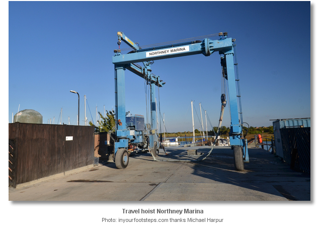
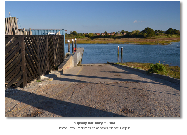
All pontoons have water and electricity and facilities for garbage disposal, and waste oil can be disposed of ashore close to the marina office. The marina has excellent showers, toilets, launderette and a clothes dryer. WiFi is available throughout the marina area. Diesel can be made available through the marina office.A travel hoist can lift vessels weighing up to 35 tons and there is hard standing for up to 200 boats ashore. The marina has a modernised slipway, with an access pontoon adjacent, that provides easy access to the water for trailer sailors along with ample space for car parking and trailer storage. There are good facilities ashore for boat owners wanting to carry out boat repairs or maintenance with many marine related tradesmen available. The nearby Shell garage has a mini market that provides some basic provisions.
The only way to and from the island from land is over Hayling Bridge. The nearest railway station to Hayling Island is Havant, just onto the mainland off Hayling Island and 2 miles from Northney Marina. Alternatively, Portsmouth and Southsea is another railway station, used for connections to Bristol (Temple Meads) and Cardiff.
Any security concerns?
Never an issue known to have occurred to a vessel berthed in Northney Marina.With thanks to:
Phil Walker Deputy Harbour Master. Photography by Michael Harpur.






This Hayling Yacht Company approach video shows the approach to Chichester Harbour and the run up the Emsworth channel to the Mill Rythe buoy after which it leads up to their marina.
The following casual video shows two fishermen entering Northney Marina at low water.
About Northney Marina
Northney Marina is owned and operated by Marina Development Limited (MDL) based in Hamble Hampshire. The company owns and manages eighteen coastal marinas and boatyards in England which includes Sparkes Marina at the entrance to Chichester Harbour. It has other facilities in France, Italy and Spain and the company provides its berth holders with freedom to roam between their extensive range of facilities without berthing fees when space is available.
The settlement of North Hayling was first documented as Heglingaigaen' in 956, and in 1256 as Northeneye from which the current name descends. The northern part of Hayling Island is the richest in terms of human inhabitation. One of Hailing’s most significant archaeological monuments, the remains of the Hayling Island Roman temple, were excavated in Touncil Field, mid-way between North Hayling village and the Havant Road. The excavations also indicated Saxon settlement activity on the site. Northney’ evidence of human occupation however dates back to at least the Bronze Age. For this area was the site of the important ‘Wadeway’ that has provided access to the Island for countless millennia.
The ‘Wadeway’ was a raised trackway that was exposed three hours either side of low water. It offered pedestrians, carts and horse riders a pathway from Langstone Village to a point on the Northney shoreline close west of where the marina is sited today. This three-quarter mile long track served the island as early as the Bronze Age. A piece of timber with an ancient axe cut found at the Hayling end of the ‘Wadeway’ was carbon dated to be 1,000 years BC. This provided an indication of just how early this route was established and the ‘Wadeway’ continued to service the island until as late as 1924. In that year a deep water channel called ‘New Cut’ was dredged through the ancient raised trackway to enable the barges of the ‘Portsmouth to Arundel Canal’ touched upon in the
entry. The ‘Wadeway’ was likewise obsoleted that year by the island’s first wooden bridge. Eventually, a toll bridge was built, and then came the railway with its own bridge situated close west of the road bridge. Despite its through-traffic Northney stayed rural with a significant concentration of early farmsteads, particularly in the 17th century, that reflected its good agricultural soils and sheltered position. Much of the land was farmed under an open field system and became enclosed by the 1870s. The area was predominantly arable with orchards around Northney and today remains comparatively little changed by 20th century development.
What has remained constant for Northney, and the harbour area as a whole, from as early as the Bronze Age is salt making by the process of evaporating seawater. Situated on the sheltered north-western shore Northney was one of the largest in the region. The activity continued on the island until the late 19th century when these systems were obsoleted by mined salt sources particularly from the salt mines of Cheshire. It is the legacy of the salterns that has created Northney Marina. For Northney Marina is built into the original footprint of what was the Northney saltern. Around the marina one does not have to look far for tangible evidence of these systems through the survival of some of the banks. Small areas of salt marshes still exist on the mudflats around the harbour today.
From a sailing perspective Northney is one of the two all-tide-access marina’s available to most visiting vessels. The very modern marina has all up-to-date facilities in a secluded location, with much of the island’s history tangible via a short walk from the pontoons. The meeting point of Langstone Harbour and Chichester Harbour is generally taken to be the position of the present road bridge, the only bridge crossing to the island, which is about 15 minutes’ walk from the marina. Large sections of the old railway bridge can be seen today close west of the present road bridge which replaced the original wooden bridge in 1956. The ancient ‘Wadeway’ is still visible today particularly at low tide. It can be seen extending between the Royal Oak at Langstone and Northney shore with oak stumps marking part of the route. It is now marked by the line of a public right of way between Langstone village and North Common. The 12th century St Peter’s church is located 20 minutes’ walk from the marina, about a mile south along Northney Road which converges with St. Peters road. It is the oldest surviving church and one of the loveliest buildings on the Island.
Other options in this area
Click the 'Next' and 'Previous' buttons to progress through neighbouring havens in a coastal 'clockwise' or 'anti-clockwise' sequence. Alternatively here are the ten nearest havens available in picture view:
Coastal clockwise:
Hayling Yacht Company - 1.1 miles SSparkes Marina - 1.8 miles SSE
Langstone Harbour - 1.6 miles SW
Southsea Marina - 2.2 miles SW
Gunwharf Quays Marina - 3.7 miles WSW
Coastal anti-clockwise:
Emsworth - 0.8 miles ENEEmsworth Yacht Harbour - 0.8 miles ENE
Pilsey Island - 1.9 miles SE
Thornham Marina - 1.2 miles E
Bosham - 2.5 miles E
Navigational pictures
These additional images feature in the 'How to get in' section of our detailed view for Northney Marina.


| Detail view | Off |
| Picture view | On |
This Hayling Yacht Company approach video shows the approach to Chichester Harbour and the run up the Emsworth channel to the Mill Rythe buoy after which it leads up to their marina.
The following casual video shows two fishermen entering Northney Marina at low water.
 A photograph is worth a thousand words. We are always looking for bright sunny photographs that show this haven and its identifiable features at its best. If you have some images that we could use please upload them here. All we need to know is how you would like to be credited for your work and a brief description of the image if it is not readily apparent. If you would like us to add a hyperlink from the image that goes back to your site please include the desired link and we will be delighted to that for you.
Add your review or comment:
Please log in to leave a review of this haven.
Please note eOceanic makes no guarantee of the validity of this information, we have not visited this haven and do not have first-hand experience to qualify the data. Although the contributors are vetted by peer review as practised authorities, they are in no way, whatsoever, responsible for the accuracy of their contributions. It is essential that you thoroughly check the accuracy and suitability for your vessel of any waypoints offered in any context plus the precision of your GPS. Any data provided on this page is entirely used at your own risk and you must read our legal page if you view data on this site. Free to use sea charts courtesy of Navionics.