
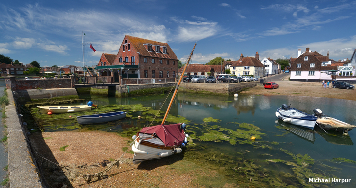
Emsworth is located on the south coast of England and in the northwest corner of Chichester Harbour. It is large village with a drying harbour and a mid-stream deep water pontoon on its approaches.
Set deep within the recesses of the large natural harbour the quay and pontoon offer good protection but are exposed to developed conditions from the south and west. Although the harbour is entered over a moderately deep sand bar, and between sand banks, it is very well marked and straightforward. Good visibility is required to avoid the moorings laying in the path to the town quay.

Keyfacts for Emsworth


Last modified
July 17th 2018 Summary* Restrictions apply
A good location with attentive navigation required for access.Facilities


Nature


Considerations


HM  +44 1243 512301
  Ch.Ch.14 [Chichester Harbour Patrol]
+44 1243 512301 Ch.Ch.14 [Chichester Harbour Patrol] Position and approaches

Expand to new tab or fullscreen
Haven position
 50° 50.657' N, 000° 56.266' W
This is the location of the Town Quay at the foot of the Emsworth Slipper Sailing CLub



What are the key points of the approach?
Offshore details are available in the westbound  or eastbound sequenced 'Selsey Bill to Start Point' coastal description. Use the Itchenor
  entry for the approaches to Chichester Harbour and Northney Marina entry for run up the Emsworth Channel from the entrance to the Emsworth south cardinal beacon.
or eastbound sequenced 'Selsey Bill to Start Point' coastal description. Use the Itchenor entry for the approaches to Chichester Harbour and Northney Marina entry for run up the Emsworth Channel from the entrance to the Emsworth south cardinal beacon.Not what you need?
Click the 'Next' and 'Previous' buttons to progress through neighbouring havens in a coastal 'clockwise' or 'anti-clockwise' sequence. Below are the ten nearest havens to Emsworth for your convenience.
Ten nearest havens by straight line charted distance and bearing:
- Emsworth Yacht Harbour - 0.2 nautical miles ESE
- Thornham Marina - 1 nautical miles ESE
- Northney Marina - 1.2 nautical miles WSW
- Hayling Yacht Company - 2.6 nautical miles SSW
- Pilsey Island - 2.9 nautical miles SSE
- Bosham - 3.1 nautical miles ESE
- Chalkdock Point - 3.1 nautical miles SE
- East Head - 3.4 nautical miles SSE
- Sparkes Marina - 3.5 nautical miles S
- Itchenor - 3.5 nautical miles SE
These havens are ordered by straight line charted distance and bearing, and can be reordered by compass direction or coastal sequence:
- Emsworth Yacht Harbour - 0.2 miles ESE
- Thornham Marina - 1 miles ESE
- Northney Marina - 1.2 miles WSW
- Hayling Yacht Company - 2.6 miles SSW
- Pilsey Island - 2.9 miles SSE
- Bosham - 3.1 miles ESE
- Chalkdock Point - 3.1 miles SE
- East Head - 3.4 miles SSE
- Sparkes Marina - 3.5 miles S
- Itchenor - 3.5 miles SE


How to get in?

Emsworth is a charming historic village situated at the head of the Emsworth Channel and on the Hampshire side of the border between Hampshire and West Sussex. It offers a deep water mid-channel visitor’s pontoon, located ½ mile south of the town, and a drying town quay where vessels may take to the hard. The village has two sailing clubs and opposite the town quay there is the separately covered marina, Emsworth Yacht Harbour
, that is accessed over a sill.
 Use the Itchenor entry for approaches to Chichester Harbour and Northney Marina entry for directions from the entrance to ‘Emsworth’ south cardinal beacon.
At the ‘Emsworth’ south cardinal beacon the channel divides with Sweare Deep, forking off at 45° to port, and the Emsworth Channel continuing northward. Pass the beacon to port and continue north between the lines of moorings that flank the channel on either side.
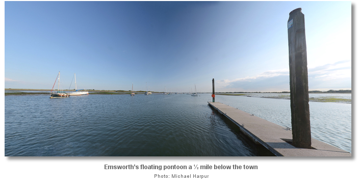
Emsworth’s floating pontoon is located on the west side of the channel ½ mile below the town. The path of the channel is made plain by the lines of deep water moorings on each side. A least depth of 3 metres can be expected up to the pontoon.

After the pontoon the Emsworth Channel increasingly narrows and becomes shallow until it eventually dries near the foot of the Fisherman's Beacon Fl(3) R.10s. Beyond the Fisherman's Beacon vessels of about 1.8 metres (6 ft.) or less can approach the Emsworth Jetty, and vessels of 1.5 metres (4 ft. 9 in) or less can reach the town quays and basin at HW +/- 2 hours.
Those continuing to Emsworth on a sufficient rise should leave the Fisherman's Beacon to port and follow the channel northward. The channel is made plain by its moorings but is also marked by red pile posts with can top marks, on the western Fowley Island side, and green piles posts with conical top marks, on the eastern Thorney Island side.
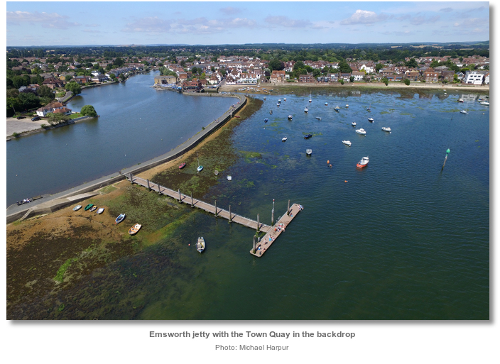
Vessels continuing past the Emsworth jetty should pass the 'Echo' starboard pile on the east side of the channel. After this follow the closely spaced port and starboard perches to a south cardinal perch. Here the channel divides with the branch tending to the northwest leading to the town quay and the branch tending eastward leading into the entrance's to Emsworth Yacht Harbour
.  Berthing options include coming alongside the visitors pontoon located about a mile to the south of the town. The visitor’s pontoon has at least 2 metres, is usually available and vessels can stay here for up to two weeks with payments made to the harbour master. Come alongside the opposite side of the pontoon to suit the prevailing weather for most comfort. The pontoon provides a good berth in conditions up to a Force 5 – 6. The isolated pontoon does not have water or electricity but is very much enjoyed for its quietness on a summers evening.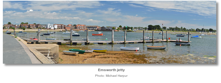
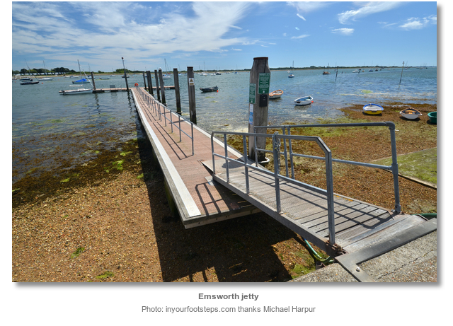
Land by tender at the drying Emsworth jetty, where fresh water may be obtained, or closer in at the town quay. As the channel dries out to the foot of the Fisherman's Beacon the Emsworth jetty can only be accessed by tender 3.5 hours each side of high water, on neap tides.
Vessels can come temporarily alongside the Emsworth jetty for a set down or pick up. Expect about 1.8 metres (6ft) of water two hours either side of High Water.

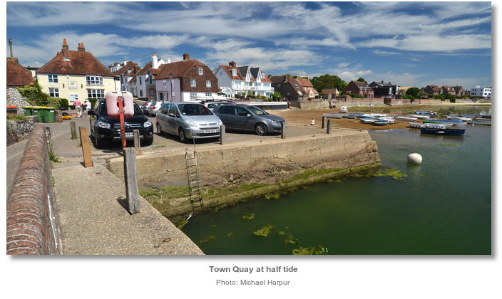
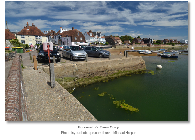
The town quay has about 1.8 metres HW +/- 2 hours and vessels that can take to the hard are more than welcome to dry out there.
Why visit here?
Emsworth origins go back to Saxon times when it was home to a small settlement. The town’s name is derived from that of the personal Saxon name of ‘Æmele’ conjoined with worth, meaning enclosure; ‘Æmele’s enclosure’. The enclosure would most likely have been an early farm or hamlet surrounded by a palisade.During the Saxon period Emsworth was linked to the nearby settlement of Warblington. Being part of the Parish of Warblington, who’s ancient Church served the whole area until comparatively recent times, Emsworth was counted into the Warblington records in the Domesday Book of 1086 and not specifically mentioned. A subsequent lowering of sea levels led to the decline of Warblington when its creek became too shallow for boats at most stages of the tide. This brought a corresponding surge in Emsworth’s growth that, being still accessible to sea traffic, grew to be the larger and more important town.

Emsworth was first noted in 1224 as Emeleswurth in contemporary records. It was recorded in 1239 that Henry III granted the town a charter to hold a weekly market and an annual fair. In 1332 Emsworth, then recorded as Empnesworth, was one of Hampshire's four Customs Ports that could actively import wine. By 1341 the town was sufficiently established as a trading and fishing port, to be one of the five ports in Hampshire ordered to provide a ship for the fleet, to be sent to protect the Channel Islands from French attack. In the following centuries malt-makers, or maltsters, grew in numbers in the Emsworth area, and some of these became rich as the rise of large-scale beer and ale brewing created a growing demand for malt. In the wars of the 1689-1713 period much of the crop went to brewers supplying Portsmouth dockyard to help quench the thirst of the sailors of England’s burgeoning navy.

The pond, which covers an area of nearly seven acres, was built in the 1760's to provide power to drive the Slipper Mill, one of three working mills in and around Emsworth. There were two further mills on the Sussex side of the River Ems and all were kept busy supplying meal for the Navy in Portsmouth. Tide mills harness the constant rise and fall of the tidal cycle by impounding a head of water in a mill pond behind a sluice gate and then releasing its energy to turn the mill wheels. Compared to wind mills they were expensive to build and could only operate for seven to ten hours each tidal day. But the power was constant and reliable which led to their development in this sheltered recess of the harbour that had the benefit of a quay. The mills reflected the change in agriculture from grazing to arable farming. All the corn they milled was locally grown and the flour was exported from Emsworth quay to feed the growing population of London.

The first half of the 19th Century was to be Emsworth’s heyday and many of its fine Georgian houses date to this period. It was by then the chief port of Chichester Harbour and almost every kind of trade was active here. These ranged from brewers to boat building with related industries, tailors, boot and shoe makers, and shop keepers selling all kinds of goods. Alongside this the town had as many as 30 beer houses catering for the thirst of the boatmen, craftsmen and traders.

Pigot's Directory of 1821 describes Emsworth as a market town whose "inhabitants live by building ships and boats, by rope and sail making, by trade in timber and by fishing." In the case of fishing the town had, at the time, the biggest fishing fleet in the harbour. Oyster fishing, in particular, flourished here but larger fishing vessels went out to sea.
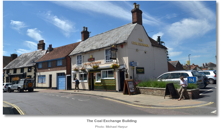
The town’s prosperity was further spurred on by the opening of the canal to Arundel in 1823, that enabled barges from Emsworth to reach the centre of Chichester. By 1836 almost half of all coastal cargoes were handled at Emsworth. Likewise, the coming of the Cosham to Chichester turnpike in 1862 vastly improved coach travel. The current ‘Crown Inn’ was where the coaches stopped to change horses whilst on their way to London or the towns of the south coast.

In 1902 Emsworth oysters were served as the first course at a banquet attended by the Dean of Winchester amongst others. He and a number of others died from typhoid and the blame fell on the oysters. A subsequent inspection of the oyster beds revealed gross sewage contamination. The sale of Emsworth Oysters were banned until the new sewage scheme was opened in 1914. After the First World War the industry got going again but never reached its previous peak.

Today Emsworth is a large village with a population of approximately 10,000 people. Its history is clear to be seen in its mediaeval street layout with St. Peter's Square as its natural focus. The town’s prosperous 18th Century is reflected in the many Georgian buildings which now front onto these streets. The older part of the waterside town still lies between its two vast mill ponds with the ‘Old Slipper Mill’ now a block of flats and ‘Quay Mill’, on the town quay, now home to the Emsworth Slipper Sailing Club. Several of the towns many public houses seen today started out in the 18th century.

The history of Emsworth is inextricably intertwined with that of the harbour and it remains so today, albeit now changed from earlier commercial activities to tourism and recreation. As a link to the past the Chichester Harbour Conservancy runs sailing trips in the very last remaining oyster boat from Emsworth’s once thriving fleet. "The Terror", as she is named, was thought to have been built in Emsworth during the second half of the 19th century. It was restored in a local boat yard in 2005-6 and takes six passengers at a time for two hour trips.

From a sailing perspective Emsworth remains a protected berth in times of inclement weather. The combined marina and visitors' pontoon makes it a popular destination for visiting yachtsmen. But it is its charming and lively town centre that is Emsworth’s main attraction. It is full of independent shops, and has a good range of historic pubs and restaurants that offer quality food at a range of prices. The town has a reputation as a ‘foodie’ favourite and late season sailors may choose to visit during the annual Emsworth British Food Fortnight. At this time it is the possible to enjoy a range of culinary events and activities along with some truly great food.
What facilities are available?
The pontoon has no services. Fresh water may be obtained further up the channel from the drying Emsworth jetty. The jetty may be approached for about two hours either side of High Water on Neaps by a vessels drawing 1.5 metres.The Emsworth Yacht Harbour pontoons provide power and water. It has private shower and toilet cubicles in two sets of facilities. Diesel is available from the fuel pontoon outside the Harbour Office. There is a Laundrette on the ground floor of the Harbour Office building with a washing machine and a dryer that are operated by tokens. Calor Gas cylinders are available from the office, and facilities are also available for general waste disposal. Wi-Fi is available free of charge across the marina for berth holders and visitors.
Emsworth Yacht Harbour have a Groves crane, a WISE boat parker and a 50 tonne travel hoist to allow them to move your boat whatever the size. They can also pressure wash your boat in the crane or hoist, on request. Winter storage is also available. They offer hardstanding for 200 boats, some of which is now gravelled. Fin keeled boats are primarily stored using cradles that may be hired from the Harbour Office. Use of the slipway and drying grid is via arrangement with the Harbour Office. The surrounding shipyard has a host of small workshops that provide a wide range of onshore facilities. This includes a sizeable and well stocked chandlery.
Emsworths two sailing clubs, the Emsworth Slipper and Emsworth Sailing Club, welcome visitors and allow them to use their bars, restaurants and washing amenities. The town has almost all the usual facilities.
Emsworth railway station is on the West Coastway Line. It has services that run to Portsmouth, Southampton, Brighton and London Victoria. Stagecoach operate the number 700 bus which operates between Brighton and Southsea. Local bus services are provided by Emsworth & District, which operate services to Havant and Chichester.
Any security concerns?
Never an issue known to have occurred to a vessel berthed alongside the pontoon or in the Emsworth Basin.With thanks to:
Sid Kenneth, Harbour Hand Emsworth, Phil Walker Deputy Harbour Master, Neil Brooke, Harbour Manager, Emsworth Yacht Harbour Ltd. Photography Barry Shimmon, Colin Smith, Tez Goodyer and Shaun Ferguson.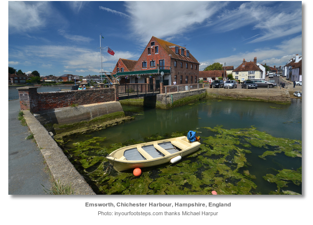


The run up to Emsworth Yacht Harbour from the Emsworth south cardinal beacon.
About Emsworth
Emsworth origins go back to Saxon times when it was home to a small settlement. The town’s name is derived from that of the personal Saxon name of ‘Æmele’ conjoined with worth, meaning enclosure; ‘Æmele’s enclosure’. The enclosure would most likely have been an early farm or hamlet surrounded by a palisade.
During the Saxon period Emsworth was linked to the nearby settlement of Warblington. Being part of the Parish of Warblington, who’s ancient Church served the whole area until comparatively recent times, Emsworth was counted into the Warblington records in the Domesday Book of 1086 and not specifically mentioned. A subsequent lowering of sea levels led to the decline of Warblington when its creek became too shallow for boats at most stages of the tide. This brought a corresponding surge in Emsworth’s growth that, being still accessible to sea traffic, grew to be the larger and more important town.
Emsworth was first noted in 1224 as Emeleswurth in contemporary records. It was recorded in 1239 that Henry III granted the town a charter to hold a weekly market and an annual fair. In 1332 Emsworth, then recorded as Empnesworth, was one of Hampshire's four Customs Ports that could actively import wine. By 1341 the town was sufficiently established as a trading and fishing port, to be one of the five ports in Hampshire ordered to provide a ship for the fleet, to be sent to protect the Channel Islands from French attack. In the following centuries malt-makers, or maltsters, grew in numbers in the Emsworth area, and some of these became rich as the rise of large-scale beer and ale brewing created a growing demand for malt. In the wars of the 1689-1713 period much of the crop went to brewers supplying Portsmouth dockyard to help quench the thirst of the sailors of England’s burgeoning navy.
The pond, which covers an area of nearly seven acres, was built in the 1760's to provide power to drive the Slipper Mill, one of three working mills in and around Emsworth. There were two further mills on the Sussex side of the River Ems and all were kept busy supplying meal for the Navy in Portsmouth. Tide mills harness the constant rise and fall of the tidal cycle by impounding a head of water in a mill pond behind a sluice gate and then releasing its energy to turn the mill wheels. Compared to wind mills they were expensive to build and could only operate for seven to ten hours each tidal day. But the power was constant and reliable which led to their development in this sheltered recess of the harbour that had the benefit of a quay. The mills reflected the change in agriculture from grazing to arable farming. All the corn they milled was locally grown and the flour was exported from Emsworth quay to feed the growing population of London.
The first half of the 19th Century was to be Emsworth’s heyday and many of its fine Georgian houses date to this period. It was by then the chief port of Chichester Harbour and almost every kind of trade was active here. These ranged from brewers to boat building with related industries, tailors, boot and shoe makers, and shop keepers selling all kinds of goods. Alongside this the town had as many as 30 beer houses catering for the thirst of the boatmen, craftsmen and traders.
Pigot's Directory of 1821 describes Emsworth as a market town whose "inhabitants live by building ships and boats, by rope and sail making, by trade in timber and by fishing." In the case of fishing the town had, at the time, the biggest fishing fleet in the harbour. Oyster fishing, in particular, flourished here but larger fishing vessels went out to sea.
The town’s prosperity was further spurred on by the opening of the canal to Arundel in 1823, that enabled barges from Emsworth to reach the centre of Chichester. By 1836 almost half of all coastal cargoes were handled at Emsworth. Likewise, the coming of the Cosham to Chichester turnpike in 1862 vastly improved coach travel. The current ‘Crown Inn’ was where the coaches stopped to change horses whilst on their way to London or the towns of the south coast.
In 1902 Emsworth oysters were served as the first course at a banquet attended by the Dean of Winchester amongst others. He and a number of others died from typhoid and the blame fell on the oysters. A subsequent inspection of the oyster beds revealed gross sewage contamination. The sale of Emsworth Oysters were banned until the new sewage scheme was opened in 1914. After the First World War the industry got going again but never reached its previous peak.
Today Emsworth is a large village with a population of approximately 10,000 people. Its history is clear to be seen in its mediaeval street layout with St. Peter's Square as its natural focus. The town’s prosperous 18th Century is reflected in the many Georgian buildings which now front onto these streets. The older part of the waterside town still lies between its two vast mill ponds with the ‘Old Slipper Mill’ now a block of flats and ‘Quay Mill’, on the town quay, now home to the Emsworth Slipper Sailing Club. Several of the towns many public houses seen today started out in the 18th century.
The history of Emsworth is inextricably intertwined with that of the harbour and it remains so today, albeit now changed from earlier commercial activities to tourism and recreation. As a link to the past the Chichester Harbour Conservancy runs sailing trips in the very last remaining oyster boat from Emsworth’s once thriving fleet. "The Terror", as she is named, was thought to have been built in Emsworth during the second half of the 19th century. It was restored in a local boat yard in 2005-6 and takes six passengers at a time for two hour trips.
From a sailing perspective Emsworth remains a protected berth in times of inclement weather. The combined marina and visitors' pontoon makes it a popular destination for visiting yachtsmen. But it is its charming and lively town centre that is Emsworth’s main attraction. It is full of independent shops, and has a good range of historic pubs and restaurants that offer quality food at a range of prices. The town has a reputation as a ‘foodie’ favourite and late season sailors may choose to visit during the annual Emsworth British Food Fortnight. At this time it is the possible to enjoy a range of culinary events and activities along with some truly great food.
Other options in this area
Click the 'Next' and 'Previous' buttons to progress through neighbouring havens in a coastal 'clockwise' or 'anti-clockwise' sequence. Alternatively here are the ten nearest havens available in picture view:
Coastal clockwise:
Northney Marina - 0.8 miles WSWHayling Yacht Company - 1.6 miles SSW
Sparkes Marina - 2.1 miles S
Langstone Harbour - 2.4 miles SW
Southsea Marina - 3 miles SW
Coastal anti-clockwise:
Emsworth Yacht Harbour - 0.1 miles ESEPilsey Island - 1.8 miles SSE
Thornham Marina - 0.6 miles ESE
Bosham - 1.9 miles ESE
Dell Quay - 3 miles ESE
Navigational pictures
These additional images feature in the 'How to get in' section of our detailed view for Emsworth.


| Detail view | Off |
| Picture view | On |
The run up to Emsworth Yacht Harbour from the Emsworth south cardinal beacon.
 A photograph is worth a thousand words. We are always looking for bright sunny photographs that show this haven and its identifiable features at its best. If you have some images that we could use please upload them here. All we need to know is how you would like to be credited for your work and a brief description of the image if it is not readily apparent. If you would like us to add a hyperlink from the image that goes back to your site please include the desired link and we will be delighted to that for you.
Add your review or comment:
Please log in to leave a review of this haven.
Please note eOceanic makes no guarantee of the validity of this information, we have not visited this haven and do not have first-hand experience to qualify the data. Although the contributors are vetted by peer review as practised authorities, they are in no way, whatsoever, responsible for the accuracy of their contributions. It is essential that you thoroughly check the accuracy and suitability for your vessel of any waypoints offered in any context plus the precision of your GPS. Any data provided on this page is entirely used at your own risk and you must read our legal page if you view data on this site. Free to use sea charts courtesy of Navionics.