

Yarmouth is located off the south coast of England on the Isle of Wight and immediately within the Western Solent. It is harbour town with a marina that offers a wide range of berthing options including swing moorings and the possibility of anchoring outside the harbour.
The small and well enclosed harbour provides good protection but can be subject to considerable swell in strong north to north easterly winds. The swing moorings and anchorage outside are entirely open to northerly component conditions and severe tide rode, making them uncomfortable in all but settled conditions. Safe access is provided in all reasonable conditions, night or day and at any stage of the tide.


Keyfacts for Yarmouth


Last modified
December 12th 2019 Summary
A good location with safe access.Facilities


Nature


Considerations


 +44 1983 760321
 info@yarmouth-harbour.co.uk
 Ch.68
Ch.68Position and approaches

Expand to new tab or fullscreen
Haven position
 50° 42.414' N, 001° 30.070' W
This is the position of the dolphin on the west side of the entrance, carrying a light QG 3M, set off the head of the breakwater extending from the western shore.
What is the initial fix?
The following Yarmouth initial fix will set up a final approach:
 50° 42.560' N, 001° 30.020' W


What are the key points of the approach?
The entry and the run-up thorough The Solent and Southampton Water are covered in
The Solent and Isle of Wight Coastal Overview.
The Solent and Isle of Wight
Coastal Overview. - Keep outside the Black Rock and East Fairway buoys on approach.
- Call the harbour office on VHF Ch 68, Call Sign [Yarmouth Harbour] to make them aware of your intentions before approaching.
- Be ready to come alongside port and starboard-side to.
- Approach on the harbours leading marks both white metal posts with a white diamond black band on the 187½°T alinement of the marks.
- Berth as directed by the Harbour Master who usually guides visitors to their berths from the entrance.
Not what you need?
Click the 'Next' and 'Previous' buttons to progress through neighbouring havens in a coastal 'clockwise' or 'anti-clockwise' sequence. Below are the ten nearest havens to Yarmouth for your convenience.
Ten nearest havens by straight line charted distance and bearing:
- Hurst Road - 1.9 nautical miles W
- Keyhaven - 2.1 nautical miles W
- Freshwater Bay - 2.4 nautical miles S
- Totland Bay - 2.4 nautical miles SW
- Lymington Yacht Haven - 2.9 nautical miles NNW
- Lymington - 2.9 nautical miles NNW
- Berthon Lymington Marina - 3.2 nautical miles NNW
- Alum Bay - 3.5 nautical miles SW
- Newtown River Entrance - 3.5 nautical miles ENE
- Newtown River - 3.7 nautical miles ENE
These havens are ordered by straight line charted distance and bearing, and can be reordered by compass direction or coastal sequence:
- Hurst Road - 1.9 miles W
- Keyhaven - 2.1 miles W
- Freshwater Bay - 2.4 miles S
- Totland Bay - 2.4 miles SW
- Lymington Yacht Haven - 2.9 miles NNW
- Lymington - 2.9 miles NNW
- Berthon Lymington Marina - 3.2 miles NNW
- Alum Bay - 3.5 miles SW
- Newtown River Entrance - 3.5 miles ENE
- Newtown River - 3.7 miles ENE


How to get in?
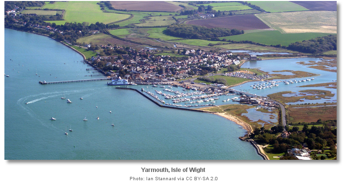
Yarmouth is a small historic town and harbour that lies on the northwest coast of the Isle of Wight. It is located just under a mile east of Sconce Point and is the Island’s most westerly harbour. The harbour is situated behind a breakwater, extending from the western bank of the River Yar, and a short ferry jetty set beneath the town’s small castle on the east side. A historic wooden pier extends about 200 metres to seaward from the east side of the castle and a church, with a conspicuous square tower, stands in the town 150 metres inland from the root of the pier. The small town is the terminus of the busy Wightlink ferry service that crosses from Lymington and is a very popular location for visiting leisure craft.
The harbour has up to 250 visitor berths of which 30 or more are made available for visitors during the summer season. Being deep, accessible at all states of the tide, and ideally located close to the Needles and the English Channel, Yarmouth receives 100,000 visitors by boat each year. Being small, with this level of activity, it can easily get overrun, especially on a fine summer weekend or when the town is holding an event. It is advisable to book at least 24 hours in advance of arrival to be certain of a berth P: +44 1202 722 458 E: yarmouthharbour@yahoo.com or book directly via their website.
When the harbour is full signs with the words ‘Harbour Full’ are displayed on either side of the entrance, one on the northern end of the short pier for the ferry and one on the dolphin. A red flag is also flown from the flag pole on the Wightlink ferry jetty. By night a ‘Harbour Full’ sign entrance is illuminated. Should the harbour be full there is usually room for visitors outside the breakwater on visitors' swing moorings and anchoring is permitted outside the line of moorings.

Vessels approaching Yarmouth should beware of the car ferries which traverse between Lymington and Yarmouth every 30 minutes. This is particularly the case for vessels approaching from the east where the wooden pier may conceal converging vessels from either direction. The initial fix provided sets up an approach by the main entrance channel that the ferries use and rule 9 applies, IRPCS Vessels in Narrow Channels, here. If there is a ferry movement, leisure craft must give way. Helmsmen should also make note that the Yarmouth RNLI lifeboat, stationed inside the harbour and on the South Quay, can leave quickly at any time without any warning.

 The Solent and Isle of Wight coastal description provides approach details. The harbour office created an excellent ‘How to Enter Slide Set’ that visually outlines the approaches and harbour area for visitors.
 Vessels on close approaches from the west should keep well clear to the north of Black Rock marked by the green conical Black Rock, Fl G 5s. From there steer towards the initial fix located about midway between the yellow spherical Poole Belle Buoy, Fl Y 5s, and the East Fairway buoy, Fl R 2s. Keep north of the lines of mooring buoys outside of the harbour north of the breakwater. Do not cut inside the lines of mooring buoys as the area off the breakwater is shoal. It is advisable to call the harbour office on VHF Ch 68, Call Sign [Yarmouth Harbour] to make them aware of your intentions on passing Black Rock buoy.
  East Fairway buoy seen off the head of the historic pier
Image: Michael Harpur
 Vessels on close approaches from the east should steer for the East Fairway buoy, Fl R 2s. The initial fix is located about 180 metres to the southwest of the buoy. It is possible for vessels approaching from the east to cut in but stand out at least 50 metres clear north of Yarmouth Pier to avoid entangling anglers fishing lines. It is advisable to call the harbour office on passing the East Fairway buoy.
 Vessels on close approaches from the north should steer for the East Fairway buoy. The helmsman should guard against tidal flows in the entrance, and within the harbour. Streams can be very strong, particularly so at half flood and ebb where on Springs rates can exceed 4 knots, and it is easy to get swept off course. A common Yarmouth mistake is to allow the tide to sweep a vessel past the entrance whilst taking the sails down. Vessels approaching the harbour from the north should close on the island shore a little up-tide of the harbour entrance to allow for this.
 Long before the initial fix Yarmouth will have made itself known by its breakwater, yacht rigs, the distinctive square church steeple and the stream of Wightlink ferries entering and exiting the harbour. Be prepared to stand off if a ferry is approaching to give them right of way. Yarmouth can be extremely busy at peak times when vessels should proceed at a dead-slow speed up to the entrance and be prepared to queue in a constrained area. Because of the tidal streams and the level of activity in the harbour area it is entirely inadvisable to enter under sail. Vessels should be ready to come alongside port and starboard-side to and maintain a listening watch on VHF Ch. 68 until made fast. Finally, before proceeding in it is essential that ‘Yarmouth Harbour’ has been contacted and instructions from the Berthing Masters should have been obtained.
 From the initial fix the 400 metres wide entrance will be plainly seen. When the car ferry is on its berth the harbour entrance is considerably reduced but made more apparent. When it is out its jetty and castle will be prominent on the east side of the entrance with the head of the ferry pier carrying a light 2 F.R (vert) 5m2M. The long breakwater extending from the west, with a dolphin off its head, stands opposite on the western side of the harbour entrance, the dolphin carries a light QG 3M.

The harbours leading marks are on the ferry jetty on the eastern side of the entrance. The front a white metal post carrying a white diamond black band. The rear mark, situated 63 metres south of the front mark, carries a white diamond black band on a white mast. The approach channel is set on the 187½° T alinement of the marks and has a minimum depth of 2.5 metres chart datum. Both marks flash green by night but the leading lights are only realistically distinguished from the bridge of a ferry. At the lower levels, as seen from a leisure vessel, they tend to merge into the clutter of town lights in the backdrop. Night entry is nonetheless relatively straightforward as the lights of the town make Yarmouth readily apparent from a distance and on final approaches the lights over the pier and jetty provide a good guide.

The speed limit reduces to 6 Knots from abeam of the head of Yarmouth’s wooden pier and throughout all the outer moorings to the Black Rock. Immediately within the entrance at the dolphin the speed limit reduces to 4 knots.
 The very helpful Berthing Masters normally pick up visitors at the entrance from where they escort them to their designated berths on the starboard side within the harbour. The whole harbour area has a maintained depth 2.0 metres below Chart Datum.
Berthing options include walk ashore pontoons and other mid-harbour pontoons that require a dingy or water taxi to alight. Some ‘fore and aft’ piles still remain but they are gradually being replaced by pontoons. In all cases, the berthing masters will direct vessels to their designated berths and provide help in coming alongside. Expect to raft up during busy periods and this is especially the case with the walk ashore pontoons.
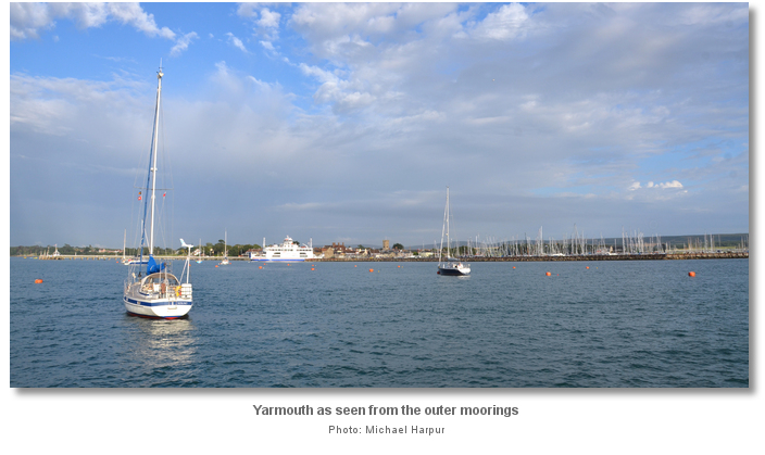
Three lines of moorings are laid outside the harbour from March to October. Vessels up to 18 metres LOA should come alongside the outer line that has a single outlying mooring off to the east to accommodate a vessel of up to 24 metres LOA. Vessels from 9 – 13 metres should come alongside the middle line and vessels up to 9 metres the inner line. The moorings follow the 3-metre contour except for two at the western end that carry 2 metres. All the moorings are entirely exposed to the north and are severely tide rode.

Those landing by tender should come alongside the pontoon adjacent to the slipway in the southeast corner of the harbour.
At the Harbour Master’s discretion, the South Quay pontoon, located to the west of the RNLI Lifeboat, may be used by vessels to set down passengers, take on fresh water or load or unload stores. These berths are for set down only and can only be used for up to 20 minutes. Vessels cannot be left unattended here and may need to be moved immediately should the RNLI Lifeboat have to leave in an emergency.

Visiting yachts are not allowed above the River Yar’s swinging road bridge but the upper reaches of the beautiful River Yar are accessible via tender. The River Yar rises near the beach at Freshwater Bay, on the south coast of the island, and flows only a few miles north to Yarmouth. The bridge opens at fixed intervals throughout the day but there is ample space for a dinghy to pass underneath at all states of tide. At high water, the estuary is navigable to the old stone 'causeway' bridge near Freshwater church, which is little more than a mile from Freshwater Bay on the south side of the island. The Western Yar is part of the Isle of Wight’s Area of Outstanding Natural Beauty and designated as a Site of Special Scientific Interest.
Why visit here?
Yarmouth takes its name from the Saxon word ‘ermud,’ or éaren, and mútha that means ‘gravelly or muddy estuary’. The place name it specifically refers to was the mouth of the River Yar and the river took its name from its estuary. The first recorded name for the site was Ermud in King Ethelred the Unready's tax records of 991 and it was recorded as the same in the 1086 Doomsday book. In 1223 it was recorded as Ernemuth and by the 14th Century it had evolved to Yaremuthe which softened to its present spelling and pronunciation.The more sheltered adjacent Thorley was the original port but Thorley Creek, through which it was accessed, gradually silted up. The 1664 mill causeway, built to create a mill pond for Yarmouth mill, sealed off the remains of the silted Thorley Creek but it is clearly visible in early maps where Yarmouth appeared almost an island. A landing place nearer to the sea had to be developed after Thorley Creek silted up and this was Yarmouth. The 991 tax receipts recorded Saxon families named Aluric and Wislac living here and the same names, most likely the direct family descendants, appear again in the 1086 Doomsday book. This makes Yarmouth one of the Isle of Wight’s very earliest settlements. It would briefly become one of the islands most important towns after the Norman Conquest.
_yarmouth_thorley_creek_as_well_as_netwtown_and_newport.jpg)
Along with, Newport and Newtown, then known as Francheville, the three towns were planned boroughs established on the island in the 12th century. The position of all three centred on navigable estuaries and sheltered harbours being more focused on their trading capability than any access to good quality agricultural land. Baldwin de Redvers, Lord of the Isle of Wight, granted Yarmouth its first charter in 1135. It conferred on the inhabitants, their heirs and successors, security of tenure and a release from the slavery of serfdom. This made Yarmouth one of the most important towns and ports on the Island and, along with Newtown, it returned members to parliament as one borough in 1295 and continued to do so, as a parliamentary borough, up until 1832. The two neighbouring towns flourished in the thirteenth century albeit with Newtown developing faster and becoming more prominent. Baldwin de Redvers descendant Isabella de Fortibus sold the island to Edward I in 1293 for 6000 marks. Henceforth the island was governed by wardens appointed by the crown, who in the reign of Henry VII were styled captains.

In 1330, the French invaded Yarmouth and St. Helens. The then King's Warden of the Island, Sir Theobald Russell, prevailed in routing them though he was mortally wounded in battle. The island, as well as Portsmouth, were again attacked by the French in March 1338. Worse was to come in 1377 when a combined French and Spanish raid burnt Yarmouth to the ground and killed many of its people. The same raid completely destroyed Newtown and Freshwater along with laying siege to Carisbrooke Castle. The Island was again attacked in 1381, and in 1402 when a French army of 1,700 men landed and raided several Island villages. The French attacked again in 1403, raiding much of the Island before being counter-attacked and driven off by forces from Portsmouth and Southampton. In 1545, supported by 130 ships, came the most serious French invasion and it wrought terrible destruction across the island. Yarmouth was burned to the ground and had its church bells carried off to Cherbourg or Boulogne. Again the Captain of the Island, Richard Worsley, led a brave defence by a local militia, repulsing the invaders and saving the island.

The raids were taking an enormous toll on the islanders. The raids were likewise followed by frequent invasion scares. Landowners sent their wives and families to the safety of the mainland for the summer months which had become considered as the ‘invasion season’. The invasions and the invasion scares were accompanied by calls on the town to provide ships and men to invade France. The burden of which was so great that islanders were abandoning the island and sanctions had to be introduced by the crown to prevent the Island from becoming deserted.
The 1545 raid, the Battle of The Solent, was to prove pivotal. In it Henry VIII dispatched his flagship, the Mary Rose, against the French only to see it founder before his eyes from Southsea Castle. Realising how close he had come to losing the Isle of Wight he ordered the construction of forts at Cowes, Sandown, Freshwater and Yarmouth which corresponded with those on the shore. Yarmouth Castle was built from stone on the site of a church destroyed by the French in 1547. The square stone artillery fort, 30 metres across, was initially equipped with 15 artillery guns and a garrison of 20 men. Despite being small and rather basic in design it featured a different style from the earlier circular bastions used in the Henrican Device Forts and was the first of its kind to be constructed in England. In 1589, at the time of the expectation of the Spanish invasion, a small fort was built at the west of the town called Carey's Sconce, named after the Island's governor Sir George Carey. Although an earth and wood structure, long since disappeared, its shape was an innovative five-pointed star-shape. It was renamed Carey's Sconce, bestowing the name Sconce Point to the headland where it once stood.

The French raids finally came to an end with the establishment of Henry VIII’s organised lines of defences. After this it was ever-present and endemic corruption that became the largest impediment to the town’s development. The appointment of Sir Robert Holmes as Governor of the Island in 1668 was an important event that would shape Yarmouth's history. Holmes filled in the moat of Yarmouth Castle, that had never experienced a shot fired in anger, built himself a house on its eastern edge, now the George Hotel, and made it his home on the island. It was a place where he could keep a keen eye on the very lucrative opportunity which the ‘vice-admiralty of the Isle of Wight’, Newport and Hampshire, provided him. This was the right to two-thirds of the value of all prizes, belonging either to an ‘enemy of England’ or to a ‘a pretended neutral’ he seized in these waters. Holmes took a very wide and liberal interpretation of the phrase 'a pretended neutral' through which he was able to add considerably to his wealth during his 20 year stay.

Today, having a population of little more than a thousand, Yarmouth remains a town of modest proportions and it is one of the smallest towns in the country. It remains a working port with a small fishing fleet and a regular ferry service to and from Lymington on the mainland. Its economy is essentially based on fishing, yachting and tourism.

Visitors will find the old town, with its Norman grid system of streets still well evident, utterly charming. Food is excellent here with plenty of local pubs and restaurants renowned for the quality of their food. An often overlooked pleasure is a dinghy trip to the upper reaches of the River Yar that provides a wonderful day out for a visiting yachtsmen. There are a host of delightful walks in the area with a walk out to The Needles available for the more energetic. For the less energetic there is a hop-on hop-off tour bus every 30 minutes that serves a number of places of interest in the West Wight area including the Needles Old Battery and Alum Bay.

From a sailing perspective it is an essential Solent cruising destination as well as an arrival or departure point for the English Channel and beyond. Being the westernmost port on the Isle Of Wight the town makes for an ideal staging point for longer journeys. This is particularly the case with the Channel Islands being a day sail, about 100 miles away.
What facilities are available?
The walk ashore pontoons have power and water – although they require a vessel to have its own hose. Water is also available on the South Quay, and Town Quay has a Fuel Berth that supplies diesel and petrol. Excellent showers and laundrette facilities are available ashore if charged separately. The harbour has a sewage pump out facility, waste oil disposal capabilities and a slipway. Calor Gas, Camping Gaz and ice are available from the Harbour Office. Wi-Fi access via Click4Internet – via an on-line payment.A crane is available for use on the West Quay. Safe Working Load 5 Tonnes except when using the lifting frame when the maximum is reduced to 4.5 tonnes. There is also a wash down facility. The town has a chandlery and a wide range of specialist services, from sail and rigging services to marine electronics, GRP repairs and cosmetic work and engineering. There are several restaurants, bars and cafes in the town and some basic provisioning.
Bus Route 7 leaves from Yarmouth Bus Station to Newport, which is a hub for the main Island destinations.
The Needles Breezer is a one hour open top bus tour of the West Wight which leaves from Yarmouth every 30 minutes during the day in the sailing season.
Any security concerns?
Never an issue known to have occurred to a vessel visiting Yarmouth. The harbour maintains a night watchperson: outside office hours, April to October. CCTV is in operation and monitored all year round. Regular land-based patrols are carried out and include areas of the harbour, river, dinghy park and pier.With thanks to:
Michael Harpur. Photography by Michael Harpur, Franzfoto, John Lucas, Ian Stannard and Christine Matthews.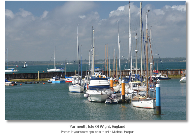


.jpg)

.jpg)


.jpg)
.jpg)
The view from a boat entering the harbour.
The view within the harbour.
About Yarmouth
Yarmouth takes its name from the Saxon word ‘ermud,’ or éaren, and mútha that means ‘gravelly or muddy estuary’. The place name it specifically refers to was the mouth of the River Yar and the river took its name from its estuary. The first recorded name for the site was Ermud in King Ethelred the Unready's tax records of 991 and it was recorded as the same in the 1086 Doomsday book. In 1223 it was recorded as Ernemuth and by the 14th Century it had evolved to Yaremuthe which softened to its present spelling and pronunciation.
The more sheltered adjacent Thorley was the original port but Thorley Creek, through which it was accessed, gradually silted up. The 1664 mill causeway, built to create a mill pond for Yarmouth mill, sealed off the remains of the silted Thorley Creek but it is clearly visible in early maps where Yarmouth appeared almost an island. A landing place nearer to the sea had to be developed after Thorley Creek silted up and this was Yarmouth. The 991 tax receipts recorded Saxon families named Aluric and Wislac living here and the same names, most likely the direct family descendants, appear again in the 1086 Doomsday book. This makes Yarmouth one of the Isle of Wight’s very earliest settlements. It would briefly become one of the islands most important towns after the Norman Conquest.
Along with, Newport and Newtown, then known as Francheville, the three towns were planned boroughs established on the island in the 12th century. The position of all three centred on navigable estuaries and sheltered harbours being more focused on their trading capability than any access to good quality agricultural land. Baldwin de Redvers, Lord of the Isle of Wight, granted Yarmouth its first charter in 1135. It conferred on the inhabitants, their heirs and successors, security of tenure and a release from the slavery of serfdom. This made Yarmouth one of the most important towns and ports on the Island and, along with Newtown, it returned members to parliament as one borough in 1295 and continued to do so, as a parliamentary borough, up until 1832. The two neighbouring towns flourished in the thirteenth century albeit with Newtown developing faster and becoming more prominent. Baldwin de Redvers descendant Isabella de Fortibus sold the island to Edward I in 1293 for 6000 marks. Henceforth the island was governed by wardens appointed by the crown, who in the reign of Henry VII were styled captains.
In 1330, the French invaded Yarmouth and St. Helens. The then King's Warden of the Island, Sir Theobald Russell, prevailed in routing them though he was mortally wounded in battle. The island, as well as Portsmouth, were again attacked by the French in March 1338. Worse was to come in 1377 when a combined French and Spanish raid burnt Yarmouth to the ground and killed many of its people. The same raid completely destroyed Newtown and Freshwater along with laying siege to Carisbrooke Castle. The Island was again attacked in 1381, and in 1402 when a French army of 1,700 men landed and raided several Island villages. The French attacked again in 1403, raiding much of the Island before being counter-attacked and driven off by forces from Portsmouth and Southampton. In 1545, supported by 130 ships, came the most serious French invasion and it wrought terrible destruction across the island. Yarmouth was burned to the ground and had its church bells carried off to Cherbourg or Boulogne. Again the Captain of the Island, Richard Worsley, led a brave defence by a local militia, repulsing the invaders and saving the island.
The raids were taking an enormous toll on the islanders. The raids were likewise followed by frequent invasion scares. Landowners sent their wives and families to the safety of the mainland for the summer months which had become considered as the ‘invasion season’. The invasions and the invasion scares were accompanied by calls on the town to provide ships and men to invade France. The burden of which was so great that islanders were abandoning the island and sanctions had to be introduced by the crown to prevent the Island from becoming deserted.
The 1545 raid, the Battle of The Solent, was to prove pivotal. In it Henry VIII dispatched his flagship, the Mary Rose, against the French only to see it founder before his eyes from Southsea Castle. Realising how close he had come to losing the Isle of Wight he ordered the construction of forts at Cowes, Sandown, Freshwater and Yarmouth which corresponded with those on the shore. Yarmouth Castle was built from stone on the site of a church destroyed by the French in 1547. The square stone artillery fort, 30 metres across, was initially equipped with 15 artillery guns and a garrison of 20 men. Despite being small and rather basic in design it featured a different style from the earlier circular bastions used in the Henrican Device Forts and was the first of its kind to be constructed in England. In 1589, at the time of the expectation of the Spanish invasion, a small fort was built at the west of the town called Carey's Sconce, named after the Island's governor Sir George Carey. Although an earth and wood structure, long since disappeared, its shape was an innovative five-pointed star-shape. It was renamed Carey's Sconce, bestowing the name Sconce Point to the headland where it once stood.
The French raids finally came to an end with the establishment of Henry VIII’s organised lines of defences. After this it was ever-present and endemic corruption that became the largest impediment to the town’s development. The appointment of Sir Robert Holmes as Governor of the Island in 1668 was an important event that would shape Yarmouth's history. Holmes filled in the moat of Yarmouth Castle, that had never experienced a shot fired in anger, built himself a house on its eastern edge, now the George Hotel, and made it his home on the island. It was a place where he could keep a keen eye on the very lucrative opportunity which the ‘vice-admiralty of the Isle of Wight’, Newport and Hampshire, provided him. This was the right to two-thirds of the value of all prizes, belonging either to an ‘enemy of England’ or to a ‘a pretended neutral’ he seized in these waters. Holmes took a very wide and liberal interpretation of the phrase 'a pretended neutral' through which he was able to add considerably to his wealth during his 20 year stay.
Today, having a population of little more than a thousand, Yarmouth remains a town of modest proportions and it is one of the smallest towns in the country. It remains a working port with a small fishing fleet and a regular ferry service to and from Lymington on the mainland. Its economy is essentially based on fishing, yachting and tourism.
Visitors will find the old town, with its Norman grid system of streets still well evident, utterly charming. Food is excellent here with plenty of local pubs and restaurants renowned for the quality of their food. An often overlooked pleasure is a dinghy trip to the upper reaches of the River Yar that provides a wonderful day out for a visiting yachtsmen. There are a host of delightful walks in the area with a walk out to The Needles available for the more energetic. For the less energetic there is a hop-on hop-off tour bus every 30 minutes that serves a number of places of interest in the West Wight area including the Needles Old Battery and Alum Bay.
From a sailing perspective it is an essential Solent cruising destination as well as an arrival or departure point for the English Channel and beyond. Being the westernmost port on the Isle Of Wight the town makes for an ideal staging point for longer journeys. This is particularly the case with the Channel Islands being a day sail, about 100 miles away.
Other options in this area
Click the 'Next' and 'Previous' buttons to progress through neighbouring havens in a coastal 'clockwise' or 'anti-clockwise' sequence. Alternatively here are the ten nearest havens available in picture view:
Coastal clockwise:
Newtown River Entrance - 2.2 miles ENENewtown River - 2.3 miles ENE
Thorness Bay - 3.5 miles ENE
Cowes Harbour - 5.2 miles ENE
Cowes Yacht Haven - 5.3 miles ENE
Coastal anti-clockwise:
Totland Bay - 1.5 miles SWAlum Bay - 2.2 miles SW
Scratchell's Bay - 2.6 miles SW
Freshwater Bay - 1.5 miles S
Ventnor - 8.2 miles ESE
Navigational pictures
These additional images feature in the 'How to get in' section of our detailed view for Yarmouth.


| Detail view | Off |
| Picture view | On |
The view from a boat entering the harbour.
The view within the harbour.
Add your review or comment:
Please log in to leave a review of this haven.
Please note eOceanic makes no guarantee of the validity of this information, we have not visited this haven and do not have first-hand experience to qualify the data. Although the contributors are vetted by peer review as practised authorities, they are in no way, whatsoever, responsible for the accuracy of their contributions. It is essential that you thoroughly check the accuracy and suitability for your vessel of any waypoints offered in any context plus the precision of your GPS. Any data provided on this page is entirely used at your own risk and you must read our legal page if you view data on this site. Free to use sea charts courtesy of Navionics.