

Lymington is located on the south coast of England and immediately within the Western Solent. It is harbour town and major sailing centre that provides a wide range of berthing options that includes two of The Solent’s largest marinas.
The small and well protected harbour provides complete protection. Safe access is provided in all reasonable conditions, night or day and at any stage of the tide.


Keyfacts for Lymington


Last modified
July 14th 2018 Summary
A completely protected location with safe access.Facilities


 pump out facilities")


Nature


Considerations

 +44 1590 672014
 harbouroffice@lymingtonharbour.co.uk
Position and approaches

Expand to new tab or fullscreen
Haven position
 50° 45.151' N, 001° 31.434' W
This is the position of the south end of the northern wave screen, at the entrance to the harbour and Horn Reach.
What is the initial fix?
The following Lymington initial fix will set up a final approach:
 50° 44.130' N, 001° 30.215' W


What are the key points of the approach?
The entry and the run-up thorough The Solent and Southampton Water are covered in
The Solent and Isle of Wight coastal description.
The Solent and Isle of Wight
coastal description. - The harbour is accessed via the Lymington River that enters The Solent through a saltmarsh.
- The river is entered between the ‘Jack in the Basket’ port beacon and a conspicious club platform with No. 1 starboard post situated close west of it.
- Follow the ample, substantive and closely spaced marks that mark the dogleg path of the river to the harbour.
- Berthing options include a marina, that lies within the harbour entrance, then a harbour pontoon 'Dan Bran', another marina and finally the Town Quay all to port.
Not what you need?
Click the 'Next' and 'Previous' buttons to progress through neighbouring havens in a coastal 'clockwise' or 'anti-clockwise' sequence. Below are the ten nearest havens to Lymington for your convenience.
Ten nearest havens by straight line charted distance and bearing:
- Lymington Yacht Haven - 0 nautical miles SW
- Berthon Lymington Marina - 0.3 nautical miles NW
- Keyhaven - 2.7 nautical miles SSW
- Hurst Road - 2.8 nautical miles SSW
- Yarmouth - 2.9 nautical miles SSE
- Totland Bay - 4.4 nautical miles SSW
- Newtown River Entrance - 4.5 nautical miles ESE
- Gins Farm - 4.7 nautical miles ENE
- Newtown River - 4.8 nautical miles ESE
- Buckler's Hard - 4.8 nautical miles NE
These havens are ordered by straight line charted distance and bearing, and can be reordered by compass direction or coastal sequence:
- Lymington Yacht Haven - 0 miles SW
- Berthon Lymington Marina - 0.3 miles NW
- Keyhaven - 2.7 miles SSW
- Hurst Road - 2.8 miles SSW
- Yarmouth - 2.9 miles SSE
- Totland Bay - 4.4 miles SSW
- Newtown River Entrance - 4.5 miles ESE
- Gins Farm - 4.7 miles ENE
- Newtown River - 4.8 miles ESE
- Buckler's Hard - 4.8 miles NE


How to get in?

Lymington is a small historic market and harbour town situated inside The Solent and three miles northeast of Hurst Point. The town is located on the west bank of the Lymington River which flows into the north side of The Solent through a saltmarsh. The west side of the river is home to two of The Solent’s largest marinas, a town quay and several pontoons and moorings. On the east side of the river there is a terminal for the busy Wightlink ferry service that crosses to Yarmouth. The town has two large sailing clubs and is a major centre for sailing.
Lymington is accessible to most leisure vessels at all stages of the tide but it is not an excessively deep harbour. The construction of a causeway in the eighteenth century has reduced the rivers scouring effect and led to shallowing. The constant toing and froing of the ferries helps keep the lower channel’s minimums to 2.4 metres chart datum, up to the entrance at Lymington Yacht Haven, and 2.2 meters chart datum, up to ferry berth and Lymington Marina. But after this the depth drops to 1.4 metres chart datum to the Town Quay which has an alongside depth of 1.5 metres chart datum along with a size restriction of 12 metres. These depths should be taken conservatively as the river is subject to silting.

Vessels approaching Lymington should pay particular attention to the car ferries which traverse between Yarmouth and Lymington about every 30 minutes via the entrance channel. If there is a ferry movement, rule 9 applies - IRPCS Vessels in Narrow Channels, and leisure craft must give way. In Lymington’s narrow fairway the ferry will take up the majority of the channel and a vessel must keep well over to starboard. When skirting the margins of the channel be aware that the skirting mud flats are very steep-to and when the ferry passes they tend to lower the water level momentarily so it is possible to briefly touch the mud. If the vessel is at a wide point or in a position where it may be conveniently stepped aside when a ferry movement is about to happen, or indeed the approach can be timed to follow the ferry in, it would be advantageous to do so.
Water skiing, aqua-planing and board-sailing are forbidden in the harbour area. Although anchoring is prohibited in Lymington River it is possible to anchor outside on the Lymington Banks inshore of the seasonal spherical race buoy.

 The Solent and Isle of Wight coastal description provides approach details. Vessels converging on the initial fix and using The Solent’s channel marks will find no specific local obstacles to an approach to Lymington Harbour. By day Lymington will make itself known from a great distance by the constant stream of Wightlink ferries that enter and exit the harbour and its forest of masts. Keeping outside the line of spherical racing buoys and Hurst Light tower bearing no less than 225° T clears the mud banks either side of the entrance. Closer in the Royal Lymington Yacht Club starting platform, located about 100 metres northwest of the outer end of the fairway, makes the approach path plain.
By night keep south of the line of seasonal spherical racing buoys, Fl Y 4s, and do not go north of Hurst Light’s white sector, Fl(4)WR.15s, until the alinement of Lymington’s leading lights Fixed Red on the 319½° T.
 From the initial fix steer up the channel on 319½° T but be prepared to stand off if a ferry is approaching. The channel is very well marked and should be adhered to as there are shoal waters on both sides. The first outer port mark is the red ‘Jack in the Basket’ beacon, Fl. R. 2s9m, on the port side that is made conspicuous by its unusual black 'basket' topmark. The starting platform will be readily identifiable on the starboard side with the No. 1 starboard post, Fl. G 2s2m3M, 60 metres west of it.
Pass between these beacons to enter the channel and then follow the closely spaced substantial piles north-westward up the Long Reach. The port side red piles, with square top marks, all flash red every 2 seconds, the starboard side green piles, with triangular top marks, to starboard all flash green every 2 seconds.
Just over ½ mile within, the channel turns northward for ¼ of a mile from the green starboard Tar Barrel beacon. This section has two black and white directional leading light-beacons, aligned on 007° ½, on metal columns for the benefit of the ferries.

The channel leads past the breakwater to starboard and then turns westward around its northern end and into Short Reach between the port hand Cocked Hat Fl.R.2s and starboard Caged Boom Fl. G. 2s 4m3M.

Following Short Reach for 400 metres leads to the harbour’s well signed entrance between wave screens either side of the fairway and into Horn Reach.
 Lymington Yacht Haven is entered to port immediately behind the southern wave screen on the west side of the river. By night it has leading lights, inline on 244° T, both fixed orange. The marina holds no specific visitor berths but does accommodate visiting yachts in the berths of resident holders that are away. P: +44 1590 677071 VHF: Ch. 80. Detail on the marina can be found in the Lymington Yacht Haven
  entry.
Horn Reach turns north-westward from the entrance, and the harbour office’s public pontoon, the Dan Bran pontoon, is situated about 200 metres up river from the Lymington Yacht Haven entrance on the port side alongside the channel. The harbour office is situated ashore close south of the Royal Lymington Yacht Club. P: +44 1590 672014

The conspicuous clubhouse of the Royal Lymington Yacht Club, with its own landing and pontoon berths, is passed to port about 200 metres beyond the Dan Bran pontoon.

Berthon Lymington Marina commences 300 metres above the club house. It is situated to port, on the west bank, opposite the Wightlink car ferry terminal. The marina can handle boats of all sizes and holds up to 70 visitor berths. Contact the marina on VHF Ch 80 or P: +44 1590 673312 call sign [Berthon Lymington Marina]. Details on the marina can be found in the Berthon Lymington Marina
entry.
After the ferry terminal is passed, the channel narrows due to the density of vessels on pile berths, and appears somewhat confused. The fairway effectively follows the line of Berthon Lymington Marina to port, and the pile berths that stand off the heads of the pontoons. It is marked by a line of prominent port piles with red cone tops.

The channel to Town Quay opens to the west opposite the second ferry berth. This is marked by port and starboard piles on either side. Turn to port and pass between the marks. Then follow the fairway between the lines of moored boats for about 400 metres to the quay walls.

The Town Quay can accommodate 150 vessels, with a maximum LOA of 12 metres and draft of 1.6 metres low water Springs. Berthing options include the walk-ashore jetty and nearby fore-and-aft moorings and mid river pontoons as directed by the harbour office P: +44 1590 672 014.

Why visit here?
Lentune, Lemyntum, Lementum, Liminton, or Lymington, under which names it has been accepted at various periods of time, derives its name from a lost Celtic river name Limen, meaning the ‘river of the elm’. The name Limen was conjoined with ‘ton’, or tún, which signifies farmstead, hamlet or village, river village.

Celia Fiennes, 1662-1741, noted in her visit to Lymington in around 1695 'it’s a mile to Limington a seaport town – it has some few small ships belonging to it and some little trade, but the greatest trade is by their salterns. She went on to observe. The seawater they draw into trenches and so into several ponds that are secured in the bottom to retain it, and it stands in the sun to exhale the watery part of it, and if it prove a dry summer they make the best and most salt, for the rain spoils the ponds by weakening the salt.
When they think its fit to boil they draw off the water from the ponds by pipes which convey it into a house full of large square iron and copper pans; they are shallow but they are a yard or two if not more square, these are fixed in rows one by another up to twenty on a side. In the house under which is the furnace that burns fiercely to keep these pans boiling apace, they shovel it up and fill it in great baskets from which the thinner part runs through on to moulds which are set to catch it, and which they call salt cakes'. Until the end of the 18th century, the area from Lymington to Hurst Spit was the site of the biggest sea salt industry in the country.

In the 18th and early 19th centuries Lymington possessed a military depot that was mostly artillery but also had several militia regiments. At the time of the Napoleonic Wars the King's German Legion-Artillery was based near Portchester Castle and sent sick soldiers to Lymington or Eling Hospital. Boat building and dairy farming contributed to the towns income that reached its seminal moment in the 18th century as is reflected in the town’s Georgian architecture today. After this the town’s industrial mainstays started to decline. High taxes and the rise of Cheshire’s lower cost mineral saltworks finally forced the closure of the last saltern in 1865. The renewed importance of Southampton in the following decades completed the decay of the importance of the town harbour.
By this time Lymington had developed into a bathing resort with a bath house at Waterford overlooking what is now Lymington Yacht Haven. It was regarded as an attractive, genteel town and there was some limited development of large houses and villas on the fringes of the town’s medieval core. Being convenient for leisure cruising in the Solent to the Isle of Wight, as well as a departure point for the English Channel and beyond, Lymington also benefited from the rise in the popularity of sailing.

It developed into a major sailing centre in the nineteenth century which in turn supported boat builders and the local tourism industry. In the twentieth century the town became home to three yacht clubs, the Royal Lymington Yacht Club founded in the 1920s as the Lymington River Sailing Club, the Lymington Town Sailing Club which was founded in 1946, and the Berthon Lymington Marina formed in 1960 to encourage younger sailors.

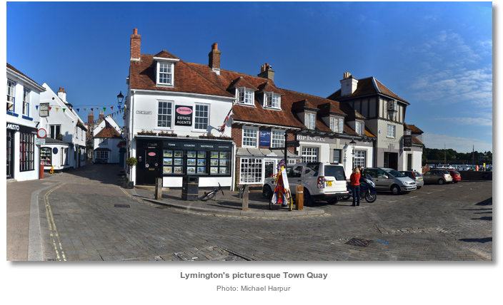
Today Lymington has retained the genteel sailing town feel. Surrounded by the beautiful countryside of the New Forest it is a magnet for tourists. The town is fortunate in that its historic structure and layout remain largely intact and it has been largely unaffected by major development. Lymington High Street has several independent shops and designer boutiques, as well as a local market held each Saturday that dates back to the original 13th century charter. It has two very large marinas, and three sailing clubs which are very active today. The Royal Lymington Yacht Club has over 3000 members and runs major keelboat and dinghy events. Lymington Town Sailing Club hosts the popular Lymington Winter Series known as the Solent Circuit. The town’s narrow streets, lined with pretty period cottages and houses, as well as plenty of local pubs and restaurants are a delight to visit and it is one of the Solent’s most popular destinations amongst yachters.

Lymington is the gateway from the Solent to the surrounding 1,330 hectares (3,300 acres) of New Forest that is protected and managed by the National Trust. Much of its coastline is also designated a special area of conservation which can be explored via the Solent Way. The western end of the 60 mile coastal walk leads out from Lymington to Hurst Castle which can be reached, by the more energetic within a two hour walk. It leads past coastal grazing, saltwater lagoons and saltmarshes with views all the way across the Solent to the Isle of Wight. Roydon Woods is a lovely area of woodland, heath, fields and meadows, with numerous streams and ponds located just south of Brockenhurst on the Lymington River.

Those who want to relax will find Lymington a bustling, cosmopolitan town steeped in Georgian and Victorian architecture with quaint cobbled streets. It has an excellent choice of local pubs and restaurants renowned for the quality of their food. Boats with small children will find a common green space and playground between the marinas, and another behind the Town Hall. There is an open air pool adjacent to the Lymington Yacht Haven that is perfect for older children.

From a sailing perspective Lymington is an essential Solent cruising destination as well as an arrival point for the English Channel and beyond. Its excellent public transport makes it ideal for crew changeovers. Being the westernmost port on the mainland side of The Solent, with excellent facilities and provisioning, the town makes for an ideal staging point for longer journeys. This is particularly the case for the Channel Islands which is a day sail, about 100 miles, away.

What facilities are available?
All yachting facilities are available in Lymington including a choice of chandleries. Lymington has all the services that you would expect from a town of this size. There are a choice of chemists, supermarkets, a post office, several banks and a host of bars and restaurants. The town also has a large range of independent shops and retailers.Any security concerns?
Never an issue known to have occurred to a vessel visiting Lymington.With thanks to:
Michael Harpur S/Y Whistler.


.jpg)
.jpg)

.jpg)


About Lymington
Lentune, Lemyntum, Lementum, Liminton, or Lymington, under which names it has been accepted at various periods of time, derives its name from a lost Celtic river name Limen, meaning the ‘river of the elm’. The name Limen was conjoined with ‘ton’, or tún, which signifies farmstead, hamlet or village, river village.
Celia Fiennes, 1662-1741, noted in her visit to Lymington in around 1695 'it’s a mile to Limington a seaport town – it has some few small ships belonging to it and some little trade, but the greatest trade is by their salterns. She went on to observe. The seawater they draw into trenches and so into several ponds that are secured in the bottom to retain it, and it stands in the sun to exhale the watery part of it, and if it prove a dry summer they make the best and most salt, for the rain spoils the ponds by weakening the salt.
When they think its fit to boil they draw off the water from the ponds by pipes which convey it into a house full of large square iron and copper pans; they are shallow but they are a yard or two if not more square, these are fixed in rows one by another up to twenty on a side. In the house under which is the furnace that burns fiercely to keep these pans boiling apace, they shovel it up and fill it in great baskets from which the thinner part runs through on to moulds which are set to catch it, and which they call salt cakes'. Until the end of the 18th century, the area from Lymington to Hurst Spit was the site of the biggest sea salt industry in the country.
In the 18th and early 19th centuries Lymington possessed a military depot that was mostly artillery but also had several militia regiments. At the time of the Napoleonic Wars the King's German Legion-Artillery was based near Portchester Castle and sent sick soldiers to Lymington or Eling Hospital. Boat building and dairy farming contributed to the towns income that reached its seminal moment in the 18th century as is reflected in the town’s Georgian architecture today. After this the town’s industrial mainstays started to decline. High taxes and the rise of Cheshire’s lower cost mineral saltworks finally forced the closure of the last saltern in 1865. The renewed importance of Southampton in the following decades completed the decay of the importance of the town harbour.
By this time Lymington had developed into a bathing resort with a bath house at Waterford overlooking what is now Lymington Yacht Haven. It was regarded as an attractive, genteel town and there was some limited development of large houses and villas on the fringes of the town’s medieval core. Being convenient for leisure cruising in the Solent to the Isle of Wight, as well as a departure point for the English Channel and beyond, Lymington also benefited from the rise in the popularity of sailing.
It developed into a major sailing centre in the nineteenth century which in turn supported boat builders and the local tourism industry. In the twentieth century the town became home to three yacht clubs, the Royal Lymington Yacht Club founded in the 1920s as the Lymington River Sailing Club, the Lymington Town Sailing Club which was founded in 1946, and the Berthon Lymington Marina formed in 1960 to encourage younger sailors.
Today Lymington has retained the genteel sailing town feel. Surrounded by the beautiful countryside of the New Forest it is a magnet for tourists. The town is fortunate in that its historic structure and layout remain largely intact and it has been largely unaffected by major development. Lymington High Street has several independent shops and designer boutiques, as well as a local market held each Saturday that dates back to the original 13th century charter. It has two very large marinas, and three sailing clubs which are very active today. The Royal Lymington Yacht Club has over 3000 members and runs major keelboat and dinghy events. Lymington Town Sailing Club hosts the popular Lymington Winter Series known as the Solent Circuit. The town’s narrow streets, lined with pretty period cottages and houses, as well as plenty of local pubs and restaurants are a delight to visit and it is one of the Solent’s most popular destinations amongst yachters.
Lymington is the gateway from the Solent to the surrounding 1,330 hectares (3,300 acres) of New Forest that is protected and managed by the National Trust. Much of its coastline is also designated a special area of conservation which can be explored via the Solent Way. The western end of the 60 mile coastal walk leads out from Lymington to Hurst Castle which can be reached, by the more energetic within a two hour walk. It leads past coastal grazing, saltwater lagoons and saltmarshes with views all the way across the Solent to the Isle of Wight. Roydon Woods is a lovely area of woodland, heath, fields and meadows, with numerous streams and ponds located just south of Brockenhurst on the Lymington River.
Those who want to relax will find Lymington a bustling, cosmopolitan town steeped in Georgian and Victorian architecture with quaint cobbled streets. It has an excellent choice of local pubs and restaurants renowned for the quality of their food. Boats with small children will find a common green space and playground between the marinas, and another behind the Town Hall. There is an open air pool adjacent to the Lymington Yacht Haven that is perfect for older children.
From a sailing perspective Lymington is an essential Solent cruising destination as well as an arrival point for the English Channel and beyond. Its excellent public transport makes it ideal for crew changeovers. Being the westernmost port on the mainland side of The Solent, with excellent facilities and provisioning, the town makes for an ideal staging point for longer journeys. This is particularly the case for the Channel Islands which is a day sail, about 100 miles, away.
Other options in this area
Click the 'Next' and 'Previous' buttons to progress through neighbouring havens in a coastal 'clockwise' or 'anti-clockwise' sequence. Alternatively here are the ten nearest havens available in picture view:
Coastal clockwise:
Berthon Lymington Marina - 0.2 miles NWLymington Yacht Haven - 0 miles SW
Keyhaven - 1.7 miles SSW
Hurst Road - 1.7 miles SSW
Christchurch Bay - 4.8 miles W
Coastal anti-clockwise:
Gull Island - 3.3 miles ENEGins Farm - 2.9 miles ENE
Buckler's Hard - 3 miles NE
Ashlett - 5.2 miles ENE
Hythe Marina Village - 5.4 miles NNE
Navigational pictures
These additional images feature in the 'How to get in' section of our detailed view for Lymington.


| Detail view | Off |
| Picture view | On |
Add your review or comment:
Please log in to leave a review of this haven.
Please note eOceanic makes no guarantee of the validity of this information, we have not visited this haven and do not have first-hand experience to qualify the data. Although the contributors are vetted by peer review as practised authorities, they are in no way, whatsoever, responsible for the accuracy of their contributions. It is essential that you thoroughly check the accuracy and suitability for your vessel of any waypoints offered in any context plus the precision of your GPS. Any data provided on this page is entirely used at your own risk and you must read our legal page if you view data on this site. Free to use sea charts courtesy of Navionics.