

Located within the protected waters of Southampton Waters and two and a half miles upriver, the marina offers complete protection. Although it can be safely accessed night or day, and at any state of the tide for most vessels, it is best that newcomers visit during daylight.


Keyfacts for Deacons Marina and Boatyard
Facilities


Nature

Considerations


Protected sectors

Approaches

Shelter
Last modified
July 17th 2018 Summary
A completely protected location with safe access.Facilities
Nature
Considerations
Enquiries  +44 23 8040 2253
  info@deaconsboatyard.com
  deaconsboatyard.co.uk
  Ch.68 [Hamble Harbour Radio]
+44 23 8040 2253 info@deaconsboatyard.com deaconsboatyard.co.uk Ch.68 [Hamble Harbour Radio] Position and approaches

Expand to new tab or fullscreen
Haven position
 50° 52.992' N, 001° 18.195' W
This is the head of the southernmost pontoon.
What is the initial fix?
The following River Hamble initial fix will set up a final approach:
 50° 50.115' N, 001° 18.660' W


What are the key points of the approach?
The entry and the run-up thorough The Solent and Southampton Water are covered in
The Solent and Isle of Wight coastal description.
The Solent and Isle of Wight
coastal description. Not what you need?
Click the 'Next' and 'Previous' buttons to progress through neighbouring havens in a coastal 'clockwise' or 'anti-clockwise' sequence. Below are the ten nearest havens to Deacons Marina and Boatyard for your convenience.
Ten nearest havens by straight line charted distance and bearing:
- Elephant Boatyard - 0 nautical miles SSW
- Swanwick Marina - 0.2 nautical miles SE
- Universal Marina - 0.6 nautical miles SSW
- Mercury Yacht Harbour - 0.8 nautical miles SSW
- Port Hamble Marina - 1.5 nautical miles SSW
- Hamble River Harbour Master - 1.9 nautical miles S
- Warsash Sailing Club - 1.9 nautical miles S
- Hamble Point Marina - 1.9 nautical miles S
- Netley - 2 nautical miles SW
- Kemps Quay - 3.3 nautical miles WNW
These havens are ordered by straight line charted distance and bearing, and can be reordered by compass direction or coastal sequence:
- Elephant Boatyard - 0 miles SSW
- Swanwick Marina - 0.2 miles SE
- Universal Marina - 0.6 miles SSW
- Mercury Yacht Harbour - 0.8 miles SSW
- Port Hamble Marina - 1.5 miles SSW
- Hamble River Harbour Master - 1.9 miles S
- Warsash Sailing Club - 1.9 miles S
- Hamble Point Marina - 1.9 miles S
- Netley - 2 miles SW
- Kemps Quay - 3.3 miles WNW

Chart

How to get in?
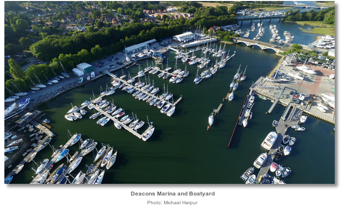
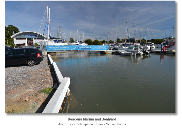
Deacons Marina and Boatyard is situated on the upper end of the meandering Hamble River, on the west bank of the river immediately before Bursledon Bridge. It is the river's sixth marina and for most sailing craft Bursledon Bridge, with an air draught of 4 metres height (MHWS), marks the effective head of navigation.
Deacons Marina and Boatyard holds no specific visitor berths and accommodates visiting yachts on the berths of resident holders that are away. Although short term berths are usually available it is advisable to make berthing arrangements in advance by contacting the marina on P: +44 23 8040 2253. The marina operates no VHF watch.

Charted depths in the river from Warsash Jetty as far as Bursledon Bridge range from 1.2 to 5.7 metres gradually reducing upriver.
Expect lowest astronomical tides in the River Hamble of at least:
- • 3 metres to Port Hamble Marina
- • 2.3 metres to Mercury Yacht Harbour
- • 2 metres past Universal to Swanwick Marina
- • 1.7 metres to Deacons with 1.5 metres at its northern end approaching Bursledon Bridge.
The River Hamble is an extraordinarily busy waterway but sailing in the river is not prohibited. The harbour master does request that all vessels operating under sail should have the engine instantly available and sails ready to be lowered should the fairway become challenged by traffic. The harbourmaster takes the view that it is unseamanlike and discourteous to other river users to use performance downwind sails in the congested waters above the Warsash Jetty.
Vessels over 20 metres LOA are required to contact the Harbour Master on entry or before getting underway P: +44 1489 576387 VHF Ch. 68 call sign [Hamble Harbour Radio]. The office in Warsash is open 8.30 am to 5 pm daily. If the office is unavailable the Hamble Patrol operates in the summer, 1 April to 30 September, from 6.30am to 10pm and in winter, 1 October to 30 April, 8.30am to 5pm. The patrol is available on M: +44 7718 146380 or +44 7718 146381. All vessels should monitor VHF Ch. 68 when underway in the harbour and river where the speed is limited to 6 knots.
 The Solent and Isle of Wight coastal description provides approach details. Vessels navigating the six-mile length of Southampton Water should keep a listening watch for Southampton VTS, on VHF Ch 12/16, especially around the docks, and give priority to commercial traffic.
Vessels converging on the entrance will find nothing in the way of local hazards by staying in reasonable soundings and following the marks. The location of the River Hamble is readily identified from a great distance by opening opposite to Fawley Power Station. Fawley's single 198 metres high chimney can be seen for miles.
 Vessels approaching the initial fix from the western Solent should take care to only cross Southampton Water when it is free of commercial shipping movements and at, as close as possible, to a right-angle to minimise inconvenience to the busy waterway.
  Vessels approaching from Southampton, should not be tempted to cut inside No. 2 East Cardinal beacon Q [3] 10s 2M for fear of running up on Hamble Spit. The spit dries 100 metres west of the mark and has a least depth of 0.4 metres out to 100 metres southward where it remains shallow for some further distance.
 It may not be necessary to round Hamble Point south cardinal buoy Q(6)+LFl. 15s situated ¼ mile southward. Depths of 0.8 to 0.9 metres exist close west of midway point between the No.2 East Cardinal beacon and Hamble Point south cardinal buoy, so check the tide times and round up accordingly. Likewise there is at least 2.7 metres for more than 100 metres northwest of the Hamble Point south cardinal so, in all events, it is possible to cut inside close north of the south cardinal, but critically, not the No.2 East Cardinal beacon.
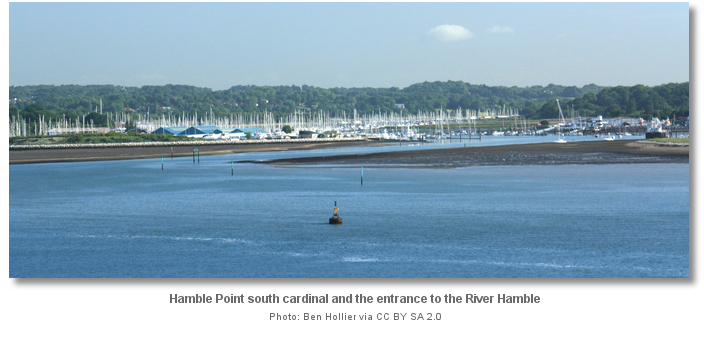
 From the initial fix steer a course of 352°T passing the Hamble Point south cardinal buoy Q(6)+LFl. 15s to port. Them align to pass the No.1 Q. G 2M to starboard and the No. 2 East Cardinal beacon Q [3] 10s 2M to port at the foot of the marked channel. After these follow the closely spaced substantial beacons, even numbers to port, odd to starboard, all fitted with radar reflectors that mark the doglegged outer fairway into the river entrance. At night, keep in the white sector Oc (2) WRG 12s, white 351°- 353°T of Hamble Common Light. This beacon is the first of two sector lights, both showing red, white and green.
Midway between starboard beacons No.5 (G) and No.7 (G) the fairway alters to starboard turning around the latter. The course now steers to 028° T in the white sector from the second sector light at Warsash Light-beacon, Iso WRG 6s, white 027° - 029°.

The Warsash Light-beacon leads into the fairway to abreast of Warsash Jetty where the main channel into the River opens up. The conspicuous Warsash Maritime Life Boat training centre, at the head of Warsash Jetty, makes for a conspicuous starboard mark.
Above the entrance keep to the starboard side of the river, between the moorings and the Warsash quays and pontoons on the west side. Although there are a number of lit navigational piles, the centre of the river is made plain by the density of the moorings in the lower river area. The sheer number of boats encountered here is astounding for most visitors. Every possible position is occupied by moorings, piles or marinas.

Whist continuing upriver the helmsman should maintain a watchful eye for vessels entering and leaving the fairway and the many skirting marinas and moorings. This is particularly the case immediately above the entrance where vessels converge and diverge for Hamble Point Marina
 . The marina is situated on the west side of the fairway set behind lines of mid-river pontoons and accommodates visitors.
On the opposite eastern bank, about ¼ of a mile above the Warsash Jetty, is the Harbour Master's Office fronting the village of Warsash. The building is a conspicuous tower circled by white with black bands with a flagstaff. The Hamble River Harbour Master
has a jetty with walk-ashore pontoons as well as mid-river piles and pontoons that they make available to visitors on a first come first serve basis. Warsash Sailing Club , the first jetty encountered opposite the Harbour Master’s mid-stream visitor’s pontoon and below its jetty, receives visitors from RYA attributed clubs.
Less than ½ a mile above Warsash on the west bank of the river is the village of Hamble, officially Hamble le-Rice, with the large scale Port Hamble Marina
, that receives visitors, will be found immediately upstream. 
Half a mile further upriver is Mercury Yacht Harbour
that is passed on the west bank of the river and receives visitors. The level of moorings suddenly reduce for a short period to a handful of swing moorings above Mercury Yacht Harbour.Here the river turns through 90° to tend north-eastward. At the apex of the bend, on the starboard side or east side of the river, is the Crableck Beacon, Q.G. with a tide gauge. Keep a good boat’s length west of Crableck. It is shallow out to 35 metres from the foot of the beacon and the river’s eastern bank dries at LWS less than 40 metres within it.
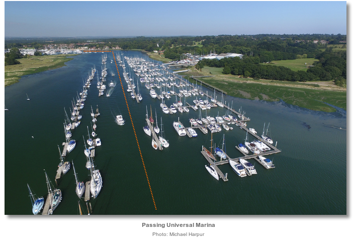
The piles and mid-river pontoons recommence shortly above in the vicinity of Universal Marina
that receives visitors. At the head of this ½ mile reach that fronts Universal Marina, the river turns again through 90° to tend north-westward. 
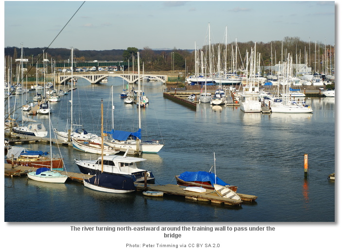
It is important to pass between the red pile to port, Q.R., and the green Swanwick, Q.G. with a tide gauge, to starboard at the apex of the bend at Bursledon Point before turning northward. Two sets of trots flank the west side of the river above. These must be passed to port passing the heads of the pontoons of
Swanwick Marina
, on the east side of the river, to starboard that receives visitors. 
The river again turns north-westward around the head of Swanwick Marina’s long ‘E’ pontoon, the fuel dock ‘F’ pontoon and a steel training wall beyond on the starboard or eastern side of the river. The Jolly Sailor pub will be seen on the opposite western or port side of the river.
From here the pontoons of the Elephant Boatyard
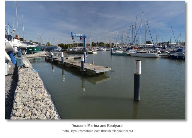
lead into Deacons Marina and Boatyard immediately beyond. Berth as directed by the marina office. As with all the River Hamble’s marinas the helmsman should be mindful of the tide state when berthing at Deacons Marina. A great measure of care is required to deal with strong cross currents that could be encountered when passing between the marina’s pontoon heads. This is especially the case on Springs when the ‘river effect’, of a very fast initial tidal drop, is amplified by the Solent’s double high ‘tidal stand’, that only provides the ebb 3 - 4 hours to complete its cycle. This creates a disproportionately sudden and strong ebb flush that requires particular attention from the helmsman.
Why visit here?
We are currently out and about finding Havens and talking to sailors like you. By popular user request we have posted this marina in advance of our local area research in order to surface its presence, pontoon arrangement and our dynamic weather, charting and tidal data.We will return presently to complete our full write up. Keep coming back to see our progress.
What facilities are available?
Deacons marina was fully re-designed in 2014 with high specification non-slip decking, lighting, smart meter electrics and wifi. It has seven unisex shower/WC cubicles and a family room ashore.Deacons Boatyard has space ashore to store up to 170 boats on two acres of hard standing. It has a lifting capacity of 20 tons and can handle vessels of up to 45 feet length. The boatyard has a highly skilled and capable workforce capable of dealing with boat repairs, big and small. The large well stocked Force 4 chandlery situated within the yard has almost any part imaginable. Swanwick Marina’s fuel berth is immediately opposite.
The marina has a fully-licensed bar and restaurant and there are plenty of excellent pubs and restaurants on either side of the river in the immediate vicinity. Swanwick post office across the river is within walking distance of the marina. The closest large supermarket is Tesco, a 20 minute walk at 1.2 miles from the marina at the top of Hamble Lane.
Located on a bend of the Hamble River, just before the A27 Bridge, road access and parking is very convenient and usually available close to the main gangways. Bursledon railway station, on the West Coastway Line, is a short stroll. It offers an hourly service between Southampton Central and Portsmouth Harbour each day of the week, with additional trains at peak periods.
Any security concerns?
The marina is a secure access area with CCTV throughout.With thanks to:
Michael Harpur S/Y Whistler. Photography Michael Harpur, Peter Trimming, Ben Hollier and Martin Speck.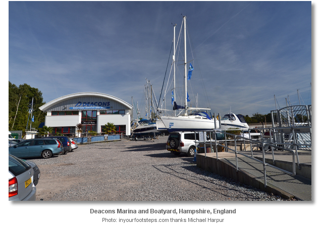


An aerial overview of the entrance to the River Hamble
A yacht being hauled out at Deacons Marina


Add your review or comment:
Please log in to leave a review of this haven.
Please note eOceanic makes no guarantee of the validity of this information, we have not visited this haven and do not have first-hand experience to qualify the data. Although the contributors are vetted by peer review as practised authorities, they are in no way, whatsoever, responsible for the accuracy of their contributions. It is essential that you thoroughly check the accuracy and suitability for your vessel of any waypoints offered in any context plus the precision of your GPS. Any data provided on this page is entirely used at your own risk and you must read our legal page if you view data on this site. Free to use sea charts courtesy of Navionics.