

Port Hamble Marina is situated on the south coast of England and within the River Hamble that flows into the northeast side of Southampton Water. It is a modern marina situated conveniently alongside the village of Hamble in a river that is a yachting centre of considerable importance.
Located within the protected waters of Southampton Waters and almost a mile upriver, the marina offers complete protection. It can be safely accessed night or day, at any state of the tide and in all reasonable conditions.


Keyfacts for Port Hamble Marina


Last modified
July 17th 2018 Summary
A completely protected location with safe access.Facilities


Nature


Considerations

Enquiries  +44 23 8045 2741
  porthamble@mdlmarinas.co.uk
  porthamblemarina.co.uk
  Ch.80 [Port Hamble Marina]
+44 23 8045 2741 porthamble@mdlmarinas.co.uk porthamblemarina.co.uk Ch.80 [Port Hamble Marina] Position and approaches

Expand to new tab or fullscreen
Haven position
 50° 51.581' N, 001° 18.719' W
This is situated on the head of the southern most 'A' pontoon.


What are the key points of the approach?
The entry and the run-up thorough The Solent and Southampton Water are covered in
The Solent and Isle of Wight coastal description. The River Hamble and its approaches are detailed the Deacons Marina and Boatyard
  entry.
The Solent and Isle of Wight
coastal description. The River Hamble and its approaches are detailed the Deacons Marina and Boatyard entry.Not what you need?
Click the 'Next' and 'Previous' buttons to progress through neighbouring havens in a coastal 'clockwise' or 'anti-clockwise' sequence. Below are the ten nearest havens to Port Hamble Marina for your convenience.
Ten nearest havens by straight line charted distance and bearing:
- Hamble River Harbour Master - 0.5 nautical miles SSE
- Hamble Point Marina - 0.5 nautical miles S
- Warsash Sailing Club - 0.5 nautical miles SSE
- Mercury Yacht Harbour - 0.7 nautical miles N
- Universal Marina - 0.9 nautical miles N
- Netley - 1.1 nautical miles W
- Swanwick Marina - 1.3 nautical miles NNE
- Elephant Boatyard - 1.4 nautical miles NNE
- Deacons Marina and Boatyard - 1.5 nautical miles NNE
- Ashlett - 2.1 nautical miles SSW
These havens are ordered by straight line charted distance and bearing, and can be reordered by compass direction or coastal sequence:
- Hamble River Harbour Master - 0.5 miles SSE
- Hamble Point Marina - 0.5 miles S
- Warsash Sailing Club - 0.5 miles SSE
- Mercury Yacht Harbour - 0.7 miles N
- Universal Marina - 0.9 miles N
- Netley - 1.1 miles W
- Swanwick Marina - 1.3 miles NNE
- Elephant Boatyard - 1.4 miles NNE
- Deacons Marina and Boatyard - 1.5 miles NNE
- Ashlett - 2.1 miles SSW


How to get in?
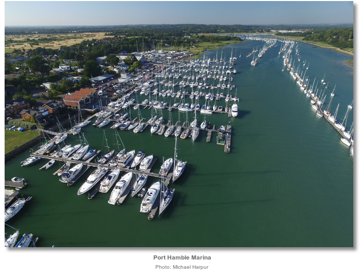
Located on the west bank of the river and immediately north of Hamble village, officially Hamble le-Rice, Port Hamble Marina is the river’s second marina and the closest to the village. It has 310 berths and can accommodate yachts of up to 24 metres in length and up to 3.6 metres draught. The River Hamble provides a draft of no less than 3 metres chart datum all the way up to Port Hamble Marina.
Port Hamble Marina holds no specific visitor berths and accommodates visiting yachts on the berths of resident holders that are away. It is therefore advisable to make berthing arrangements in advance by contacting the marina on VHF Ch. 80 or P: +44 2380 452741.

 The Solent and Isle of Wight coastal description provides approach details. Vessels navigating the six-mile length of Southampton Water should keep a listening watch for Southampton VTS, on VHF Ch 12/16, especially around the docks, and give priority to commercial traffic. Vessels converging on the entrance will find nothing in the way of local hazards by staying in reasonable soundings and following the Solent’s ample marks. The entrance to the River Hamble is made known from a great distance by being almost opposite to Fawley Power Station in Southampton Water. Fawley's 198 metres high chimney makes a conspicuous mark throughout the central Solent and beyond.
The approaches and run up the river as far as the Bursledon Bridge, the effective head of navigation for most sailing craft, are covered in the Deacons Marina and Boatyard
entry. Berth as directed by the marina office. As with all the River Hamble’s marinas the helmsman should be mindful of the tide state when berthing at Port Hamble Marina. A great measure of care is required to deal with strong cross currents that could be encountered when passing between the marina’s pontoon heads. This is especially the case on Springs when the ‘river effect’, of a very fast initial tidal drop, is amplified by the Solent’s double high ‘tidal stand’, that only provides the ebb 3 - 4 hours to complete its cycle. This creates a disproportionately sudden and strong ebb flush that requires particular attention from the helmsman.
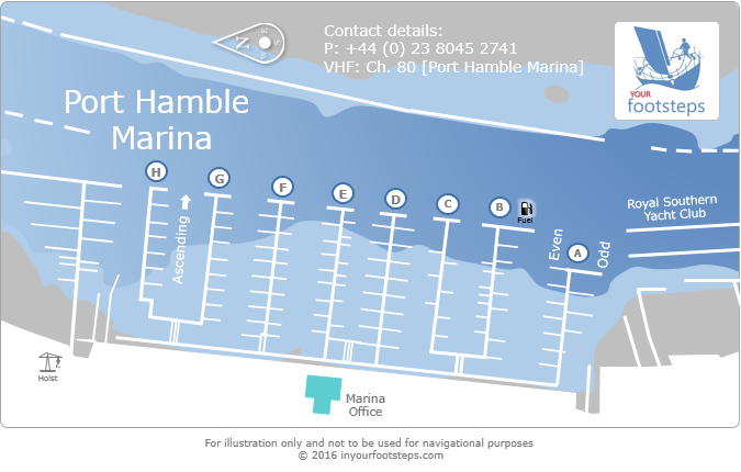
Why visit here?
We are currently out and about finding Havens and talking to sailors like you. By popular user request we have posted this marina in advance of our local area research in order to surface its presence, pontoon arrangement and our dynamic weather, charting and tidal data.We will return presently to complete our full write up. Keep coming back to see our progress.
What facilities are available?
The pontoons provide power and water. All domestic requirements up to and including WiFi can be found within the marina area. A launderette is open 24 hours a day. Diesel and unleaded petrol are available at the fuel bay located at the head of pontoon ‘B’. Gas cylinders are also available at the Marina Reception. The marina provides general waste disposal, and full recycling facilities. Arrangements can be made for the disposal of waste oil.The marina provides its lifting & boat storage services at MDL’s other two sites on the River Hamble, Hamble Point Marina and Mercury Yacht Harbour. There is a large scale chandlery onsite and a wide range of specialist services from rigging services to marine electronics, GRP repairs and cosmetic work and engineering. A very good restaurant and bar overlooks the marina. A 5 minute walk is Hamble-Le-Rice which features several restaurants and pubs plus a useful Co-op where provisions may be bought.
Access to the marina by road from the M3 is via the M27 Eastbound for Portsmouth. Exit at junction 8 of the M27 for Southampton East/Hamble taking the B3397 to Hamble. The B3397 is the only main access road that serves the Hamble Peninsula. Approximately 3 miles long and running straight through the village it is subject to a high volume of road traffic, with daily traffic congestion and slow moving queues.
The village is served by Hamble railway station, which provides services to both Southampton Central and Portsmouth Harbour. These services run once per hour in each direction. From Hamble rail station a local bus service operates to Hamble village. It is also linked by ferry to Warsash, and has bus services from pre-dawn to late night / early morning to and from Southampton and Eastleigh.
Any security concerns?
The marina is a secure access area with CCTV throughout.With thanks to:
Michael Harpur S/Y Whistler. Photography Michael Harpur.


About Port Hamble Marina
We are currently out and about finding Havens and talking to sailors like you. By popular user request we have posted this marina in advance of our local area research in order to surface its presence, pontoon arrangement and our dynamic weather, charting and tidal data.
We will return presently to complete our full write up. Keep coming back to see our progress.
Other options in this area
Click the 'Next' and 'Previous' buttons to progress through neighbouring havens in a coastal 'clockwise' or 'anti-clockwise' sequence. Alternatively here are the ten nearest havens available in picture view:
Coastal clockwise:
Hamble Point Marina - 0.3 miles SNetley - 0.7 miles W
Kemps Quay - 2.5 miles NW
Saxon Wharf Marina - 2.5 miles NW
Shamrock Quay - 2.4 miles NW
Coastal anti-clockwise:
Mercury Yacht Harbour - 0.4 miles NElephant Boatyard - 0.9 miles NNE
Deacons Marina and Boatyard - 0.9 miles NNE
Swanwick Marina - 0.8 miles NNE
Universal Marina - 0.5 miles N
Navigational pictures
These additional images feature in the 'How to get in' section of our detailed view for Port Hamble Marina.


| Detail view | Off |
| Picture view | On |
Add your review or comment:
Please log in to leave a review of this haven.
Please note eOceanic makes no guarantee of the validity of this information, we have not visited this haven and do not have first-hand experience to qualify the data. Although the contributors are vetted by peer review as practised authorities, they are in no way, whatsoever, responsible for the accuracy of their contributions. It is essential that you thoroughly check the accuracy and suitability for your vessel of any waypoints offered in any context plus the precision of your GPS. Any data provided on this page is entirely used at your own risk and you must read our legal page if you view data on this site. Free to use sea charts courtesy of Navionics.