

Located within The Solent and at the head of Southampton Water the marina offers complete protection. It can be safely accessed night or day, at any state of the tide and in all reasonable conditions.


Keyfacts for Town Quay
Facilities


Nature


Considerations


Protected sectors

Approaches

Shelter
Last modified
July 17th 2018 Summary
A completely protected location with safe access.Facilities
Nature
Considerations
 +44 23 8023 4397
 info@townquay.com
 townquay.com/marina/
 Ch.80 [Town Quay]
Position and approaches

Expand to new tab or fullscreen
Haven position
 50° 53.642' N, 001° 24.238' W
This is at the entrance and the head of the south-eastern wave-break. At night it exhibits a light 2FG [vert].


What are the key points of the approach?
The entry and the run-up thorough The Solent, Southampton Water and River Test are covered in
The Solent and Isle of Wight coastal description.
The Solent and Isle of Wight
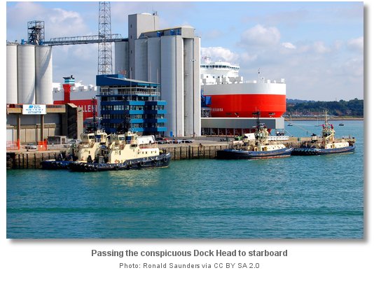
coastal description. - Enter the River Test by passing Dock Head to starboard.
- Proceed ¾ of a mile upriver beyond the cruise liner docks maintaining a careful watch for ferry and ship movements.
- The marina is accessed via a dogleg between two floating wave-breaks that appear continuous from seaward.
Not what you need?
Click the 'Next' and 'Previous' buttons to progress through neighbouring havens in a coastal 'clockwise' or 'anti-clockwise' sequence. Below are the ten nearest havens to Town Quay for your convenience.
Ten nearest havens by straight line charted distance and bearing:
- Ocean Village Marina - 0.6 nautical miles E
- Hythe Marina Village - 1.1 nautical miles S
- Shamrock Quay - 1.2 nautical miles NE
- Marchwood Yacht Club - 1.5 nautical miles WNW
- Saxon Wharf Marina - 1.5 nautical miles NE
- Kemps Quay - 1.6 nautical miles NE
- Eling - 3.1 nautical miles WNW
- Netley - 3.2 nautical miles SE
- Universal Marina - 3.8 nautical miles ESE
- Mercury Yacht Harbour - 3.8 nautical miles ESE
These havens are ordered by straight line charted distance and bearing, and can be reordered by compass direction or coastal sequence:
- Ocean Village Marina - 0.6 miles E
- Hythe Marina Village - 1.1 miles S
- Shamrock Quay - 1.2 miles NE
- Marchwood Yacht Club - 1.5 miles WNW
- Saxon Wharf Marina - 1.5 miles NE
- Kemps Quay - 1.6 miles NE
- Eling - 3.1 miles WNW
- Netley - 3.2 miles SE
- Universal Marina - 3.8 miles ESE
- Mercury Yacht Harbour - 3.8 miles ESE

Chart

How to get in?

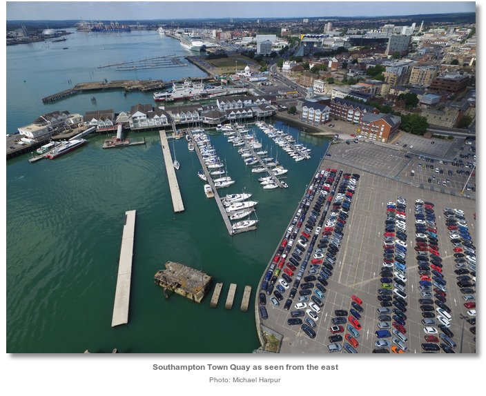
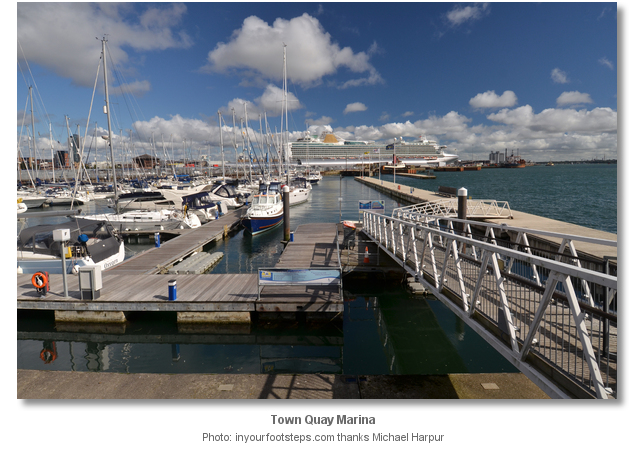
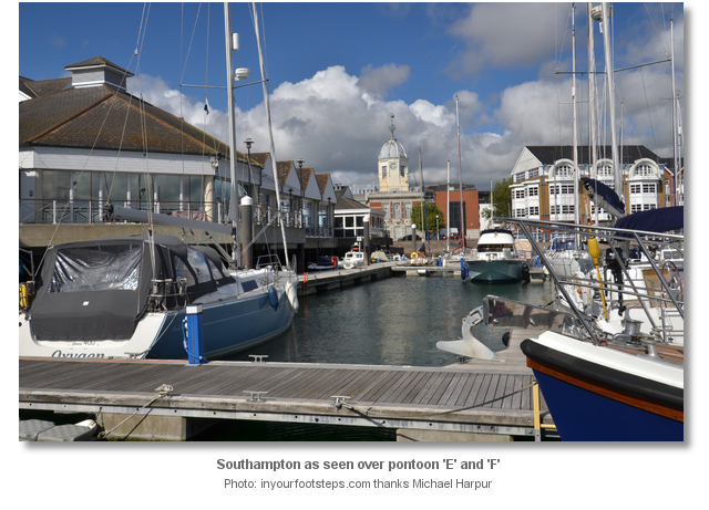
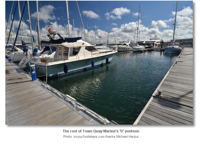
Town Quay lies on the northeast shore of the River Test that is entered from the north of Southampton Water. The historic quay is at the heart of the Southampton City’s waterfront. It is an active commercial quay that provides ferry services to the Isle of Wight and across the water to Hythe. The marina is sited at the foot of the quay and is one of five marinas that the large port city offers to leisure craft.
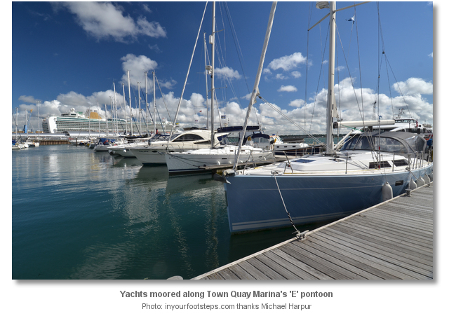
Town Quay has 136 berths and can accommodate yachts of up to 19 metres in length, 2.7 metres in draught and a beam of up to 5.5 metres. Southampton Water provides a maintained depth of not less than 13.2 metres chart datum up to the Town Quay and there is at least 2.5 metres up to and inside Town Quay Marina.
Visitor berthing is available year-round, £3.20/m inc. VAT (2016) checkout 10am. Short Stays of up to 4 hours are available £8.50 inc. VAT or over 13 metres LOA £10.50 (2016). Set downs are available with a donation to their preferred charity box. The staff will be delighted to assist a vessel entering or exiting a berth. The Marina Reception is open 24 hours a day and contactable on VHF Channel 80 M: +44 7764 29 35 88.
 The Solent and Isle of Wight coastal description provides approach details. Vessels will find nothing in the way of local hazards by staying in reasonable soundings and following the ample marks.
 Yachts navigating the six-mile length of Southampton Water should keep a listening watch for Southampton VTS, VHF Ch 12/16, especially around the docks, and give priority to commercial traffic. Whenever practicable it is preferable that leisure craft should use the largely navigable waters outside the buoyed commercial shipping channels. There is a speed limit of 6 kn. in the area north of a line joining Hythe Pier and Weston Shelf.
Break off from the Itchen River description at Dock Head, standing at the confluence of the rivers Test and Itchen, and continue up the River Test by passing Dock Head to starboard. The River Test is dredged to 13.2 metres as far as the turning circle close north of Marchwood Yacht Club
 and 12.6 metres as far as the swinging ground at the top end of the container berths one mile further. Above this point the river shoals rapidly and dries up to Eling Channel and the well-sheltered Eling Basin.
 Proceed upriver beyond the cruise liner docks to the marina which is situated on the starboard side of the river ¾ of a mile above and close to the city centre.

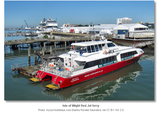
The helmsman should maintain a careful watch for ferry and ship movements in this run. This final leg crosses the lower swinging ground of the Ocean Terminal and is shared with the Fast Cat and the Hythe ferry services. These passenger services frequently shuttle back and forth to the Isle of Wight and Hythe from berths immediately outside the marina’s entrance so all vessels will be converging on the same point.

On the final approach stay close to the Ocean Docks, passing the old BOAC pontoon supports to starboard, and make for the marina entrance. The entrance is accessed via a dogleg between two floating wave-breaks that will appear continuous from seaward.
Two large blue and arrowed signs with 'VHF Channel 80' on the foot of the inner wave break, and 'Town Quay Marina' located close to the head of the outer breakwater and entrance, make the wave breaks and opening obvious. At night the ends of the wave-breaks exhibit a light, the inner north-western 2FR [vert] and outer south-eastern 2FG [vert].
 Berth as directed by the marina office.
Why visit here?
Southampton is the largest city in the ceremonial county of Hampshire. Both the city and the county derive their names from the most common elements in old English place names; hám, hamm and tún.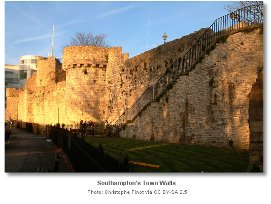

The history of human inhabitation goes back to the Stone Age and this is supported by several archaeological finds. Following the Roman invasion of Britain in AD 43 the important Roman settlement of Clausentum was built on the east bank of the Itchen where the suburb of Bitterne exists today. Inscribed stones, coins, pottery, and many millstones have been uncovered here. Defended by a wall and two ditches and thought to have contained a bath house the Clausentum settlement was not abandoned until around 410.
The Anglo-Saxons formed the new larger Hamwick settlement across the Itchen in what is now the St Mary's area of the city. With an estimated population of 4,000 - 5,000 it was very large by Saxon standards and was an important port. The Danish invasions commenced in about 840 and laid the impetus for the creation of the modern Southampton, Suhampton, that gradually came to supersede the Saxon town of Hamwick as the did the latter Roman settlement. The new site was chosen for its stronger position and greater facilities for trade but it was initially much smaller than the old Anglo-Saxon town. At the time of Domesday, 1086, it may have had about 1,000 inhabitants. Nevertheless the Witan, the Saxon parliament, declared Canute king of England at Southampton and the new 10th century fortified settlement built around it went on to form the nucleus for medieval Southampton.

Following the Norman Conquest in 1066, Southampton developed to become a major port of transit between the then capital of England and Normandy. It was a royal borough before 1086, and a charter of Henry II in 1154-5 declared that the men of Southampton shall hold their gild liberties and customs as in the time of Henry I. The Normans built a wooden castle in Southampton, and in the 12th century Southampton Castle was later rebuilt in stone. In medieval times Southampton owed its importance to the fact that it was the chief port of Winchester. It had a large import and export trade, and in the 13th century was the second wine port in England. Wool was a large export and the fact that it was brought to Southampton to be shipped probably led to the establishment of the woolen trade in the west of England.

Alongside this there were many craftsmen such as carpenters, blacksmiths, potters, leather workers and thatchers making a wide range of goods in the town. At the end of this period Southampton ranked third in the list of kingdom ports behind London and Bristol. But by then the port had reached the upper reaches of its first high water and was set for decline.

Southampton’s gradual decline of trade during the 16th and 17th centuries came about for many reasons. The rise of London as a port, the prohibition of the export of wool, the loss of the Winchester market after the suppression of the monastic institutions, and the withdrawal of the court were chief amongst many. However the port was most notably as the point of departure for the Pilgrim Fathers in 1620 for North America on the Mayflower and the smaller Speedwell. The Speedwell, originally built in Southampton, had come from Holland to meet the Mayflower before making the crossing together. However, she was leaky, some say sabotaged deliberately, and put into Dartmouth and Plymouth for repairs. There she was deemed too unreliable to attempt the crossing and the ship’s personnel and stores were transferred to the Mayflower who completed the passage alone. By the 18th Century Southampton was better known as a fashionable spa town and sea-bathing resort than as a port. But the coming of the 19th Century, and especially the Victorian period, where to see the commencement of Southampton’s second flood tide.

The history of the modern importance of Southampton as a port begins with the creation of a pier and harbour commission in 1803 and the erection of the Royal Pier or Royal Victoria Pier as it is also known. This was the first jetty or pier in Southampton and it was opened by Princess, afterwards Queen, Victoria in 1831. It was used by steamers to the Channel Islands, Le Havre and the Isle of Wight. The Southampton Docks company was formed in 1835 and in 1838 the foundation stone of Southampton docks was laid with the first dock 'Outer Dock' being opened in 1842. This was followed in 1851 by the closed non-tidal ‘Inner Dock’ that was connected to the 'Outer Dock' by locks; both of which are the site of the present day 'Ocean Village'. The continental steamers moved to the 'Outer Dock' once the railway arrived.
The structural and economic development of the docks continued for the next few decades. Though the harbour ranks as one of the finest natural harbours in the UK, that has the advantage of its unique double high tide, its present prosperity truly dates back to the opening of railway communication with London in 1840. The combination of the railway facilities and new dockyards gave Southampton the title of ‘The Gateway to the Empire’ and the town experienced major expansion when the Empire was at its zenith during the Victorian era.

The seeds of its current cruise liners commenced in the late 19th century when Southampton became the home port for the transatlantic passenger services. Most notable amongst these was, the RMS Titanic that sailed out from Southampton in 1912. Four in five of the crew on board the vessel were Sotonians, as the denizens of the city are called, with about a third of those who perished in the tragedy hailing from the city. During World War I more than 2,000 men from Southampton lost their lives. More than 8 million men passed through the port on their way to the war front.

From as early as 1913 flying boats were made in Southampton, and after the war from 1919 a flying boat mail and passenger service commenced from Royal Pier Southampton to the Channel Islands, Bournemouth, Portsmouth and the Isle of Wight. At that time, runways suitable for large aircraft were scarce and aeroplane engines less reliable. In the event of engine trouble passengers and crew were safer over water in a marine hull, rather than a craft with wheels and a lightweight frame. In 1938, Southampton docks also became home to the flying boats of Imperial Airways. From this company the Supermarine Spitfire came to be designed and developed in Southampton. It evolved from the Schneider trophy-winning seaplanes of the 1920s and 1930s. Passenger traffic as a whole boomed in the 1930’s with as many as 75,000 people passing through Southampton in 1933.

World War II brought wholesale destruction to the city. Being a major commercial port and industrial area the city was specifically targeted by the Luftwaffe. It remained a bombing target up until as late as 1944, as after D-Day and the invasion of Europe, Southampton docks handled the military supply chain. During these five years of bombing, 630 people lost their lives, 2,000 or more were injured, 4,000 homes were destroyed and 11,000 buildings seriously damaged in the city.

The number of passengers travelling through the port also declined as air travel became common in the 1960's but Southampton adapted. In the 1980's and 1990's some of the old docks were converted into areas of shops, offices and marinas. New shopping centres were built such as the Bargate in 1989 and the Marlands in 1991 and West Quay in 2000. Today Southampton has a population of quarter of a million and it continues to flourish. An increasing numbers of ships are calling into it as a port and it served 1.7 million passengers in 2015. It is considered the cruise capital of the UK, if not Europe.

From a sailing perspective Town Quay places a visitor at the very heart of the Old Town. All the cities theatres, unique galleries and museums, plus lots of intimate music and comedy venues are within a short stride. Sadly much of the city was levelled and there has been extensive redevelopment since World War II. However pockets of Georgian architecture survived the war and about half of the walls dating back to 1175, culminating in the completion of the western walls in 1380, can be seen today. 13 of the original towers, and six gates survive.
Chief amongst these are the 800 year old Bargate which was originally built as the main gateway to the medieval city. Those in search for some retail therapy will have the city shopping centres, speciality shops, boutique shopping and local markets all close at hand. The Old Town features a host of excellent eating out venues.
What facilities are available?
All pontoons have water and electricity and facilities for garbage disposal, and waste oil can be disposed of ashore close to the marina office. The marina has recently been refurbished and now has excellent laundry, toilet and shower facilities with family sized shower/changing rooms and baby changing facilities. Fuel may be obtained from Hythe Marina, close south, or Itchen Marine on the River Itchen upstream of the Itchen Bridge. The marina is within walking distance of the West Quay shopping centre and the main city centre as a whole, which has an estimated population of 253,651 and has the resources to cater for all needs.Southampton City Buses run past this marina on a regular basis passing to the centre of town within 5 minutes. 500 metres away is Dock Gate 4 and Oxford Street which is the culinary centre of Southampton. A cash point machine can be found in the Red Funnel Terminal 2 building close at hand.
Being a major city and commercial port Southampton has excellent transport connections. The adjacent ferry and fast catamarans, ply their way to Cowes on the Isle of Wight or Hythe. Mainline trains are available to London Waterloo which takes 70 minutes, Poole, Weymouth, Portsmouth and Brighton. These are complemented by a wide variety of local and regional bus services. Southampton International Airport with internal and continental flights is a 30 minute taxi ride in free flowing traffic.The M27 motorway which connects to the M3 and A3 is a 30 minute’s drive from the marina.
Any security concerns?
The marina is highly attentive to security. Gates are coded and a 24 hour security system is maintained with CCTV.With thanks to:
Michael Harpur S/Y Whistler. Photography by Michael Harpur, Ronald Saunders._stitch.jpg)


Add your review or comment:
Please log in to leave a review of this haven.
Please note eOceanic makes no guarantee of the validity of this information, we have not visited this haven and do not have first-hand experience to qualify the data. Although the contributors are vetted by peer review as practised authorities, they are in no way, whatsoever, responsible for the accuracy of their contributions. It is essential that you thoroughly check the accuracy and suitability for your vessel of any waypoints offered in any context plus the precision of your GPS. Any data provided on this page is entirely used at your own risk and you must read our legal page if you view data on this site. Free to use sea charts courtesy of Navionics.