

Located well within the protected natural harbour and sheltered from the fairway by an islet, the marina provides complete protection and one of the stillest berths in Portsmouth Harbour. Safe access is available night or day, at any state of the tide and in all reasonable conditions.

Keyfacts for Royal Clarence Marina
Facilities


Nature


Considerations


Protected sectors

Approaches

Shelter
Last modified
July 17th 2018 Summary
A completely protected location with safe access.Facilities
Nature
Considerations
 +44 23 9252 3523
 info@royalclarencemarina.org
 Ch.80 [Royal Clarence Marina]
Position and approaches

Expand to new tab or fullscreen
Haven position
 50° 48.086' N, 001° 7.332' W
This is the head of Pontoon E within the entrance.


What are the key points of the approach?
The entry and the run-up thorough The Solent and Southampton Water are covered in
The Solent and Isle of Wight coastal description. Approaches to Portsmouth Harbour and its entry can be found in the Gunwharf Quays Marina
  entry.
The Solent and Isle of Wight
coastal description. Approaches to Portsmouth Harbour and its entry can be found in the Gunwharf Quays Marina entry.- Continue up the harbour from the Ballast Bank for almost ½ a mile off the western shore.
- Follow the line Gosport Oil Fuel Jetty to the marina’s entrance.
Not what you need?
Click the 'Next' and 'Previous' buttons to progress through neighbouring havens in a coastal 'clockwise' or 'anti-clockwise' sequence. Below are the ten nearest havens to Royal Clarence Marina for your convenience.
Ten nearest havens by straight line charted distance and bearing:
- Gosport Marina - 0.3 nautical miles SE
- Haslar Marina - 0.6 nautical miles SSE
- Gunwharf Quays Marina - 0.7 nautical miles SE
- Hardway Sailing Club - 0.9 nautical miles NNW
- Stokes Bay - 1.9 nautical miles SW
- WicorMarine Yacht Haven - 2.5 nautical miles NNW
- Port Solent Marina - 2.6 nautical miles NNE
- Portsmouth Marine Engineering - 3.3 nautical miles NW
- Southsea Marina - 3.4 nautical miles E
- Fareham Marina - 3.5 nautical miles NW
These havens are ordered by straight line charted distance and bearing, and can be reordered by compass direction or coastal sequence:
- Gosport Marina - 0.3 miles SE
- Haslar Marina - 0.6 miles SSE
- Gunwharf Quays Marina - 0.7 miles SE
- Hardway Sailing Club - 0.9 miles NNW
- Stokes Bay - 1.9 miles SW
- WicorMarine Yacht Haven - 2.5 miles NNW
- Port Solent Marina - 2.6 miles NNE
- Portsmouth Marine Engineering - 3.3 miles NW
- Southsea Marina - 3.4 miles E
- Fareham Marina - 3.5 miles NW

Chart

How to get in?

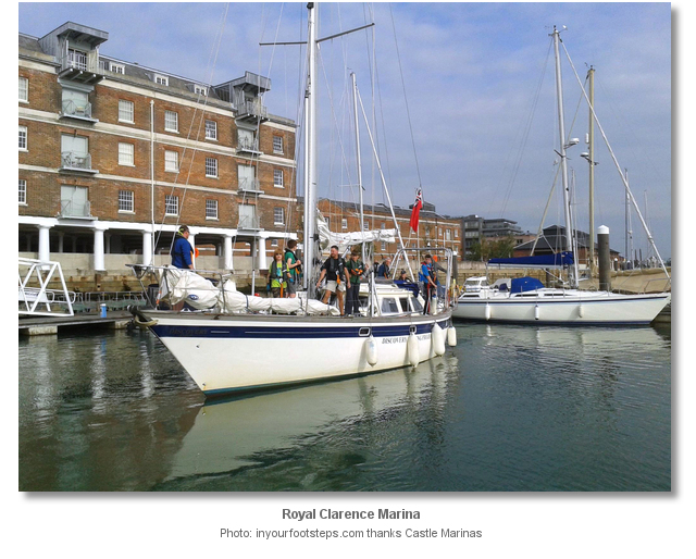
Royal Clarence Marina is situated on a peninsula in Gosport on the western side of Portsmouth Harbour opposite the City of Portsmouth. The marina is located a mile within the entrance on the western side and near the centre of Gosport Town.
Royal Clarence Marina has 145 berths and caters for visitors. It can accommodate vessels with drafts of up to 4.5 metres and 60 metres LOA. On B & C pontoons the marina has several heavy-duty pontoons that are suitable for superyachts with drafts of up to 5.25 metres.
It is preferable but not necessary to contact the marina 24 Hours in advance on P: +44 23 9252 3523, E: info@royalclarencemarina.org to arrange a berth. However, the marina will most likely invariably accommodate a vessel so it is always worth reaching out by phone or VHF Ch. 80 call sign [Royal Clarence Marina] for short notice requirements.

 The Solent and Isle of Wight coastal description provides approach details. Approaches to Portsmouth Harbour and its entry can be found in the Gunwharf Quays Marina entry.
Continue up the harbour from the head of the Boat Channel, at the Ballast Bank mark, for almost ½ a mile passing the entrance to Gosport Marina. Follow the outside line of the Gosport Oil Fuel Jetty into the entrance to the marina immediately north.

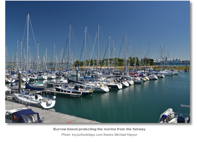
Keep well clear of the series of unlit green piles about 100 metres north of the jetty, on the starboard side, that mark the drying Weevil Lake. Weevil Lake, composed of mud and stones, extends from Burrow Island out almost 200 metres towards Portsmouth Dockyards and the same distance southward with the unlit green piles marking its extremity. The drying area and islet provide the marina with some of the most protected waters in the harbour. At night the ambient light from the Gosport Oil Fuel Jetty makes the marina approach path readily apparent.
Berth as directed by the marina office. 
Why visit here?
Royal Clarence Marina takes its name from Royal Clarence Yard that was established here in 1831. The yard was named after the Duke of Clarence a title that was traditionally awarded to junior members of the English Royal family. It also took the form of an earldom for Queen Victoria's son Prince Leopold, Duke of Albany and his son Prince Charles Edward, the Clarence earldom being a subsidiary title.

The Royal connection came in the late 1840’s when the renovation of Osborne House, see the Osborne Bay
entry, near Cowes on the Isle of Wight, was completed. Queen Victoria personally chose the yard for a convenient point of access to her cherished house. She had a royal railway station built in the yard, which meant she could travel to the mainline station in Gosport, and then on into the yard where it was just a few steps to her Royal Yacht to take her over to the island. To cater for this the ramparts were opened and a 500 metre extension laid into the Royal Clarence Yard where a Royal Station was built. The station consisted of a single curved platform flanked on one side by a long wall. There was a waiting room for Royal travelers but it is said that Queen Victoria, who would have passed through here hundreds of times, never used it. When the Queen used the station a carpet was laid between the train and the Royal Yacht. 
The yard was at peak production during World War II when it provided food and supplies for ships based in Portsmouth Harbour, the Solent and nearby areas that were taking part in Operation Overlord. In 1944, the Royal Clarence Yard also supplied the thousands of troops anchored at Spithead waiting for the go ahead for D-Day. Catering to the Allied invasion fleet with the many necessities required for the number of personnel and ships was an exceptional undertaking. At the time locals recalled the invasion fleet being packed into Spithead so tightly that they could practically walk across to the Isle of Wight from deck to deck. At this time three 10,000-gallon tanks were used to take fresh water out to the invasion fleet. Each week 400 tons of potatoes, 100 tons of meat and 50 tons of fresh vegetables were shipped from the yard. The bakery alone made and packaged 33,000lbs of bread each week and at its peak was capable of producing 10,000 ships’ biscuits an hour making it the largest bakery in England, if not the world. The yard was also involved in victualing operations for the Falklands conflict in 1982.

During World War II however the yard suffered damage and the removal of modern storage buildings left gaps in the historic layout, resulting in under-utilised and undefined spaces. Falling into decline it was finally sold by the Ministry of Defence to Berkeley Homes for development in 1991. Berkeley Homes added exclusive homes and the marina, and attempted to create a vibrant hub of restaurants, bars and leisure facilities that would mirror those of Gunwharf Quay opposite.

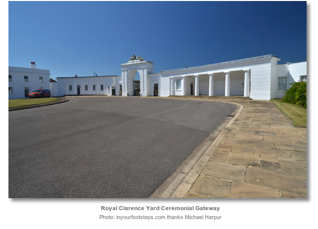
Today Royal Clarence Yard is one of two remaining royal yards in the country. The site sits adjacent to a Site of Special Scientific Interest and includes two Conservation Areas containing 18 Grade II and II* listed buildings and Scheduled Monuments. Key buildings remaining today include the Cooperage, Granary, Bakery with its ovens, oak beams and cast iron columns, the Slaughterhouse, Hydraulic Engine House, Artificer’s Workshops, Ceremonial Gateway, Superintendent’s Houses, Reservoir, Barracks and Guard House. The slaughterhouse and ornamental gates are still in place and Brewhouse Square, Cooperage Green and Flagstaff Green tell of the past. Queen Victoria’s extension line from Gosport Station, leading through the town ramparts to Weevil Lane, is being restored and a new track has been laid along this short section. The area as a whole is now mostly housing and an area of maritime based businesses.

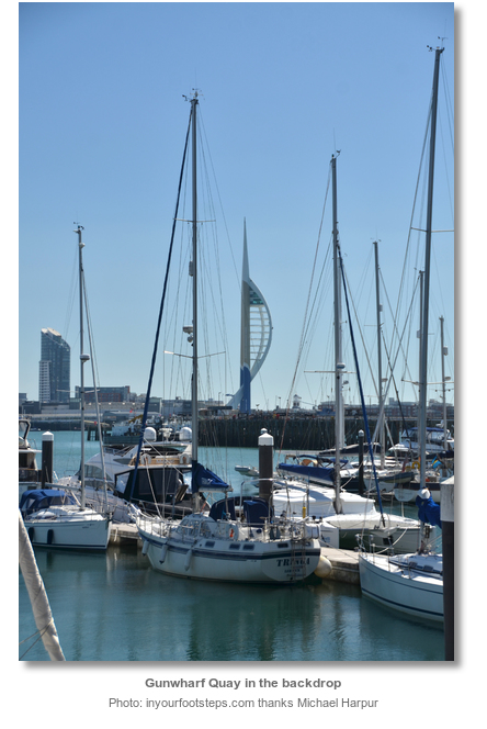
From a sailing point of view the historic yard provides the marina with unique and genuine character. But there are many more attractions to this marina. Just as it served the naval yards that lay opposite, today the marina is situated close to three present day Gosport supermarkets. All are within a five minute walk so it continues to serve boaters interested in convenient provisioning. The sheltering Weevil Lake and Burrow Island provide Royal Clarence Marina with some of the most protected berths in the harbour and there is little tidal stream in the deep naval basin to contend with. Likewise it is a peaceful berth as the shore developments never took off, unlike the adjacent Gunwharf Quay, making for a restful repose. Yet the venues of Gosport and the ferry to Old Portsmouth are all with a 10 minute walk.

Royal Clarance Marina is a TransEurope Marina. Visitors who have a homeport belonging to the TransEurope Marinas network will have the benefit of a 50% discount off berthing fees for up to 5 days.
What facilities are available?
All pontoon berths provide fresh water and electricity though visitors need to ask for a connection in the Marina Office. The marina offers special facilities for larger boats including a heavy duty pontoon with a higher freeboard and a 3 phase 125 amp power supply. Wifi is also available across the marina and access can be granted via the marina office. The shower/toilet facilities are located a short walk from the pontoons back towards Cooperage Green and are available 24 hours, seven days a week for berth holders and visitors. The launderette facilities are also available 24 hours and include a washing machine and dryer. The marina offers waste recycling.There are a wide range of marine trades, sail lofts, chandlers, repairs and maintenance, marine engineers etc, in the area but no boatyard. Gosport High Street is five minutes away with at present three supermarkets, shops and banks all within a five minute walk. The Gosport Ferry provides quick access to Portsmouth Harbour railway station, terminus of the Portsmouth Direct Line to London. A ferry service to and from Gosport operates every 15 minutes.
Any security concerns?
Pontoon and bridgehead access is restricted and only available to guests through a secure electronic gate. The marina area has CCTV camera coverage.With thanks to:
Rob Jezard, Royal Clarence Marina Manager. Photography with thanks to Castle Marinas, Karen Roe, Dysdera and Gordon James Brown.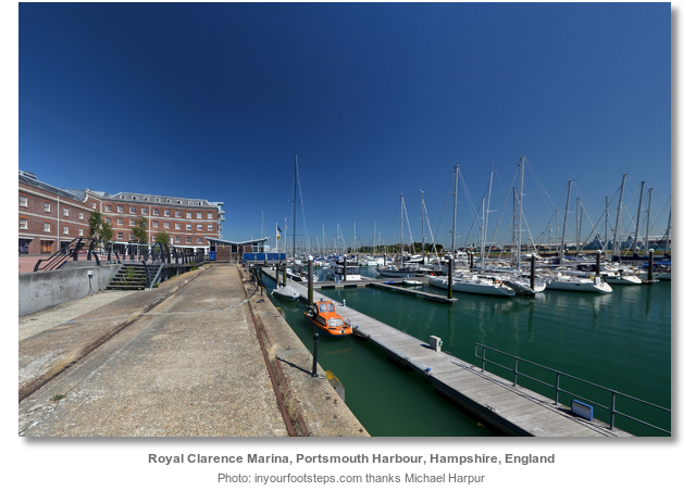


Royal Clarence Marina Aerial


Add your review or comment:
Please log in to leave a review of this haven.
Please note eOceanic makes no guarantee of the validity of this information, we have not visited this haven and do not have first-hand experience to qualify the data. Although the contributors are vetted by peer review as practised authorities, they are in no way, whatsoever, responsible for the accuracy of their contributions. It is essential that you thoroughly check the accuracy and suitability for your vessel of any waypoints offered in any context plus the precision of your GPS. Any data provided on this page is entirely used at your own risk and you must read our legal page if you view data on this site. Free to use sea charts courtesy of Navionics.