
Open to the ocean, South Harbour provides a tolerable anchorage that is exposed to everything with a southerly component. It is also subject to a heavy rolling swell that makes it an unreliable anchorage. However, it does offer very good protection northwest round to northeast gales with good holding behind high ground. Daylight access is straightforward as the island and inlet are very easily located, and there is little in the way of off-lying dangers.


Keyfacts for South Harbour (Ineer)
Facilities

Nature


Considerations

Protected sectors

Approaches

Shelter

Last modified
August 2nd 2021 Summary* Restrictions apply
A tolerable location with straightforward access.Facilities
Nature
Considerations
Position and approaches

Expand to new tab or fullscreen
Haven position
 51° 26.000' N, 009° 30.150' W
In the north end of the inlet, west of centre, on the 5 metre contour.
What is the initial fix?
The following South Harbour initial fix will set up a final approach:
 51° 25.413' N, 009° 30.131' W


What are the key points of the approach?
Offshore details are available in southwestern Ireland’s Coastal Overview for Cork Harbour to Mizen Head  .
.
. Not what you need?
Click the 'Next' and 'Previous' buttons to progress through neighbouring havens in a coastal 'clockwise' or 'anti-clockwise' sequence. Below are the ten nearest havens to South Harbour (Ineer) for your convenience.
Ten nearest havens by straight line charted distance and bearing:
- North Harbour (Trawkieran) - 0.5 nautical miles N
- Calf Island East - 3.2 nautical miles NNE
- Kinish Harbour - 4.2 nautical miles NE
- Castle Island (South Side) - 4.5 nautical miles N
- Horseshoe Harbour - 4.5 nautical miles ENE
- Long Island - 4.5 nautical miles NNW
- Castle Ruins - 4.7 nautical miles NE
- Castle Island (North Side) - 4.7 nautical miles N
- Trá Bán - 4.8 nautical miles NE
- Coney Island - 4.8 nautical miles NNW
These havens are ordered by straight line charted distance and bearing, and can be reordered by compass direction or coastal sequence:
- North Harbour (Trawkieran) - 0.5 miles N
- Calf Island East - 3.2 miles NNE
- Kinish Harbour - 4.2 miles NE
- Castle Island (South Side) - 4.5 miles N
- Horseshoe Harbour - 4.5 miles ENE
- Long Island - 4.5 miles NNW
- Castle Ruins - 4.7 miles NE
- Castle Island (North Side) - 4.7 miles N
- Trá Bán - 4.8 miles NE
- Coney Island - 4.8 miles NNW

Chart

What's the story here?
 Yacht anchored in South Cove
Image: Peter Maher via CC BY-SA 4.0
South (Ineer) Harbour is set within the extensive and deep cove on the south side of the islands the imposing Cape Clear Island. A mile to the southwest, 3 miles long, in an east and west direction, and 1 mile wide the island is high, precipitous, and bold, especially on its southern side, where it rises abruptly from the sea to the height of 159 metres. The island is waisted, with its waist being called literally 'The Waist'. The cove of North Harbour forms the landward side of the waist, but the South Harbour inlet, on the seaward side, forms the largest part of the waist being much more extensive as well as deeper.
_as_seen_from_the_shore_.jpg) South Harbour (Ineer) as seen from the shore
South Harbour (Ineer) as seen from the shore Image: Colin Park via CC BY-SA 2.0
The beautiful inlet offers a fair-weather anchorage in 4 to 6 metres west of the centre near the head of the harbour. There is a small quay on the east side at Illaunfaha. However, secure it may appear it does not afford permanent shelter to a cruising vessel in rough weather. Save for gales from northwest round to northeast it always has such a heavy swell and reflux of the sea that is so powerful as to draw vessels out to sea.
How to get in?

 Use Ireland’s coastal overview for Cork Harbour to Mizen Head for seaward approaches. Cape Clear Island is readily identifiable from seaward; being the south-westernmost corner of Ireland and having Fastnet Rock located four miles to the southwest.
  Fastnet Rock seen over Blananarragaun the inlet's western entrance and island's southernmost point
Image: Superbass via CC ASA 4.0
The island is high and bold with the northerly mainland increasing in height in the backdrop. To the east of Clear Island, the shore retains its bold aspect but is less indented. The island is three miles long, in an east and west direction, and a mile wide, precipitous, and bold, especially on its southern side, where it rises abruptly from the sea to the height of 159 metres, but slopes more gradually to the north. Two wind motors will be seen on the summit of the island. The ruins of an old lighthouse, that was replaced by the Fastnet Rock lighthouse, will be seen about midway along the south side of the island, at a height of 133 metres and about ¾ of a mile eastward of South Harbour.
 The old lighthouse located about ¾ of a mile eastward of South Harbour
Image: Superbass via CC ASA 4.0
South or Ineer Harbour is an extensive and deep inlet on the south side of the island. The entrance lies between Pointanbullig on the east side and Blananarragaun, Cape Clear’s most southerly point, on the west and has clear approaches from all directions. The western and southern side of the Cape Clear is free of dangers, all around, with steep and bold-to shores having 20 to 40 metres of water 200 metres off.
 The outer entrance to South Harbour
Image: Tourism Ireland
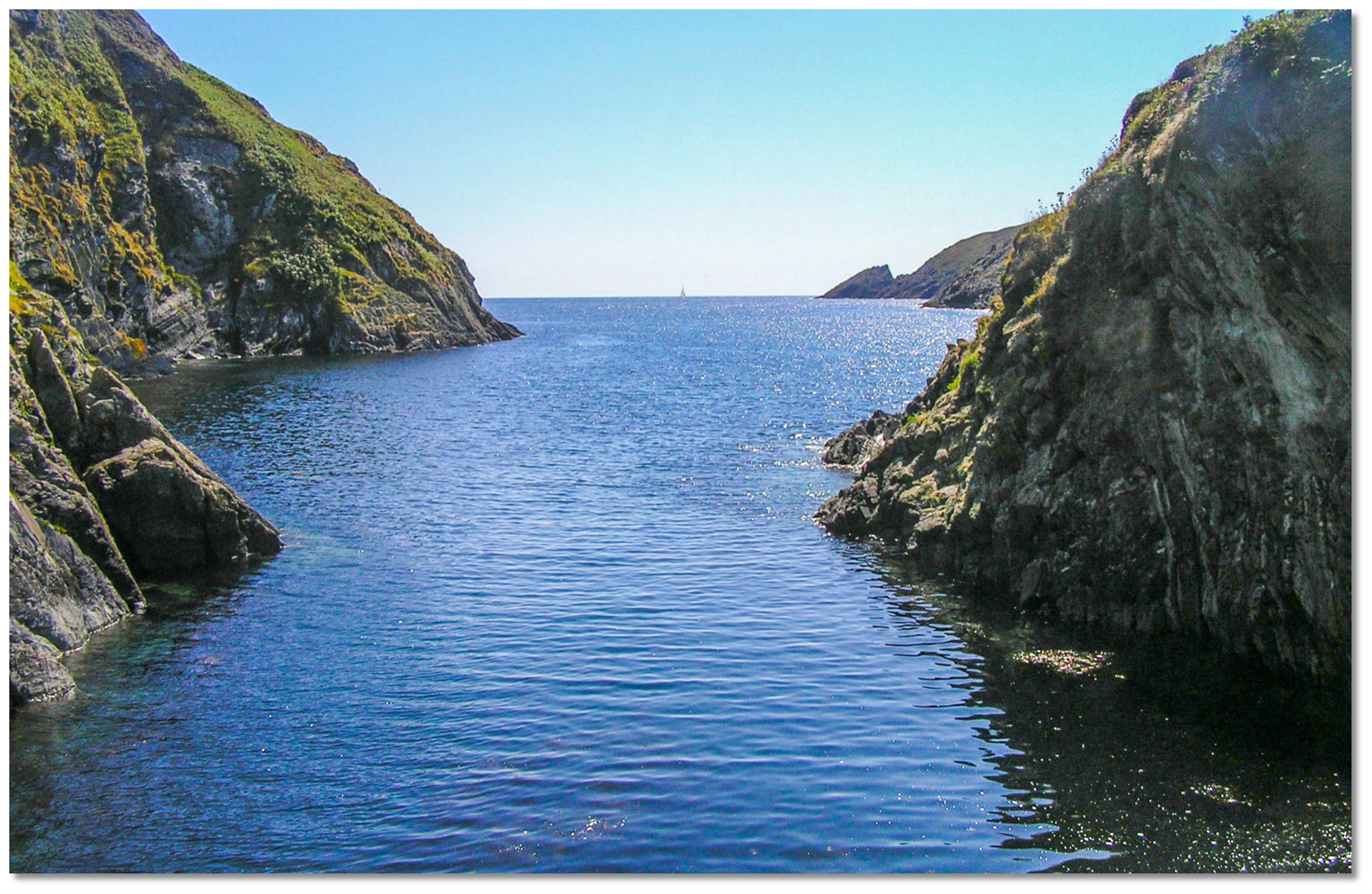
 From the Initial Fix progress northward steering for the centre of the outer entrance to the sea inlet. The outer entrance is about a ½ mile wide and has 40 metres of water. There are no outlying dangers apart from an awash rock that extends about 100 metres off Pointanbullig, the eastern entrance point.
  South Harbour as seen from the north
Image: Gabriela Avram via CC BY 2.0
The inlet then narrows to about 300 metres wide about ⅓ of a mile within Pointanbullig but there is plenty of water all the way with depths in excess of 20 metres for the majority of the passage.
 Yacht anchored off the small old quay Illaunfaha Anchor in 4 to 6 metres west of the centre near the head of the harbour. There is a lovely small old quay on the east side of the harbour, called Illaunfaha. It is possible to land at the steps here at high water or on a stony beach at low tide.
Why visit here?
Cape Clear Island, that is known as Cléire and sometimes also referred to in Irish as Oileán Chléire', is Ireland's most southerly populated island. The island as a whole is covered in the primary North Harbour Trawkieran entry. Being somewhat removed from the 'relatively' busy primary North Harbour the beautiful and unspoilt South Harbour is the epitome of the true Cape Clear experience.Image: Colin Park via CC BY-SA 2.0
South Harbour is also the ideal location from which to visit the old Cape Clear lighthouse and signal tower that can be seen on the middle summit of the island. A road that leads to these buildings can be found near the disused telegraph station that is situated close to the quay at the head of the inlet.
Image: Colin Park via CC BY-SA 2.0
Built in 1818 the Cape Clear Island lighthouse was soon found to be sited too high as it was often obscured by cloud and fog. This became a major concern as the lighthouse was a key navigation mark that served as a primary landfall for many Atlantic crossings. In November 1847 this height issue was to finally prove fatal when, in thick fog, the American sailing packet Stephen Whitney mistook the Crookhaven Lighthouse for the Clear Island light. Adjusting its course northward relative to what it thought was Clear Island it quickly ran up on Calf Island West. 92 of its 110 passengers and crew died and this disaster finally provided the impetus required to replace the Clear Island light. This would be with a new offshore light on Fastnet Rock.
 Fastnet Rock Lighthouse circa 1900
Image: Public Domain
Construction of what would be the first Fastnet lighthouse started in 1853, and it produced its first light in January 1854. This first tower was made of cast iron with an inner lining of brick and stood it 19.43 metres high. It proved to be no match for the savage seas off this wild corner of Ireland. At this time lighthouses were manned and gales shook it to the point that the lighthouse keeper's crockery was sometimes thrown off tables. A 60 imperial gallon (273 L) cask of water that was lashed to the gallery, 40.5 metres above high water, was taken away in another storm. During a gale in November 1881 the whole of the nearby Calf tower, above its strengthening casing, was carried off the rock. On the same day, the sea broke the glass of the Fastnet Rock lantern. Despite various efforts to strengthen the tower, including fitting a casing around the bottom section as far up as the second floor, that was itself filling it with stone, engineers came to the conclusion that it had to be replaced.
 The remains of the old structure can be seen on today
Image: Burke Corbett
Levelling of the site for the second and present lighthouse commenced in 1897. This was to be a new circular granite tower that was designed by William Douglass, an engineer with Irish Lights. This tower was constructed from interlocking coarse-grained Cornish granite blocks believe to have come from the Cheeseswring quarry in Bodmin Moor in Cornwall. The stones were cut in such a fashion that they had dovetail joints extending out in all directions so that they interlocked to give inherent strength to the tower. This system, known as dovetail toggling, bonded the entire structure into a monolith. No stone can be removed unless all stones are removed, top-down from its eighth level.
 The remains of the project's depot overlooking Crookhaven today
Image: Michael Harpur
The tower consisted of 2,047 blocks that weighed 4,300 tons. To minimise the work that would have to be done on the rock, it was first erected in sections in its Cornwall yard. It was then shipped by steamer to the project's depot at Crookhaven. Once checked it was then dismantled and transported to Crookhaven. Here it was rigorously checked again before being transported out to the Fastnet Rock by the 'SS Ierne' a ship specially built to carry stones. These interlocking stones were then set in place on the rock in June 1899. A further 120 cubic metres of granite was used to fill the inside of the tower up to the level of the entrance floor, 18 metres above the highwater mark.
Image: Michael Harpur
When complete the beautifully waisted masonry tower stood 45 metres high, with a focal point of the light 48 metres above the high-water mark. The first light was showed from it in 1903. The original tower's first floor was retained, on the highest part of the rock, having been left when it was demolished and converted into an oil store. Today the lighthouse, painted white and now with a helicopter platform standing on its south-western side, has proven itself well capable of withstanding the seas of this area. This is nothing to be taken for granted. In 1985, a rogue wave that measured 48 metres, 157 feet, high struck the lighthouse. On 16 October 2017, a wind gust of 191 kilometres per hour (119 mph) was recorded at the lighthouse, during a tropical storm, Hurricane Ophelia. This is an Irish record, based on measurements going back to the 1860s.
 Interlocking dovetail granite seen in the early foundations of the tower
Image: Public Domain
Fastnet of course needs no introduction to the avid yachtsman. Its name has been given to the sea area used by the Shipping Forecasts on BBC's Radio 4 and is used as the midpoint of the classic RORC's Fastnet Race that has taken place every second year since 1925. The Fastnet Race is a 608 mile, or 1,126 kilometres, round trip from Cowes on the Isle of Wight, round-the-rock and back to Plymouth. It is a difficult contest that tests both inshore and offshore skills, boat and crew preparation, alongside speed potential. The 28th 1979 Fastnet Race, with 306 competitors, was to go down in infamy after being struck by an August storm of unusual ferocity. A deep depression passing over southwest Ireland raised unnaturally violent seas that caused 23 yachts to be lost or abandoned and the death of 19 people contestants.
backdrop
Image: Burke Corbett
But these stories of stormy seas are very much removed from the times that South Harbour will be used; in fine settled weather, when it is a secluded haven of tranquil bliss. The island records some of the highest amounts of sunshine hours in Ireland, and should an auspicious weather window open, South Harbour is a perfect sun-trap in which to enjoy a sunny day.
 South Harbour as seen from the head of the inlet
Image: Tourism Ireland
From a boating perspective, South Harbour has the added interest of being the most southern anchorage in Ireland, and when viewed from the shore could be the countries’ most beautiful. For boats with a family, it is an ideal location to let children off in a dinghy, to swim or explore the immediate harbour area. Calm conditions are needed to paddle around here. It is worth remembering it does not a permanent shelter so be away when the forecast hints of any trouble.
 Yachts anchored off in South Harbour
Image: Gabriela Avram via CC BY 2.0
What facilities are available?
Apart from the quay at Illaunfaha there are no facilities here. There is an 'An Oige' youth hostel at the South Harbour. Half a mile away, which is 20 minutes’ walk, across the saddle from the Illaunfaha quay there is a restaurant.Any security concerns?
Never a security issue known to have occurred to a vessel on Clear Island.With thanks to:
Burke Corbett, Gusserane, New Ross, Co. Wexford.Aerial views of the North and South Harbours and the old lighthouse


Add your review or comment:
Please log in to leave a review of this haven.
Please note eOceanic makes no guarantee of the validity of this information, we have not visited this haven and do not have first-hand experience to qualify the data. Although the contributors are vetted by peer review as practised authorities, they are in no way, whatsoever, responsible for the accuracy of their contributions. It is essential that you thoroughly check the accuracy and suitability for your vessel of any waypoints offered in any context plus the precision of your GPS. Any data provided on this page is entirely used at your own risk and you must read our legal page if you view data on this site. Free to use sea charts courtesy of Navionics.