
.jpg)
Accessed through a lock, and at the head of the protected natural harbour, the marina provides complete protection from all conditions. Safe access is available in all reasonable conditions, night and day and for the vast majority of vessels at all stages of the tides.


Keyfacts for Port Solent Marina


 pump out facilities")


Nature


Considerations


Protected sectors


Summary
A completely protected location with safe access.Nature
Considerations
 +44 2392 210 765
 portsolent@premiermarinas.com
 Ch.80 [Port Solent]
Position and approaches

Haven position
 50° 50.627' N, 001° 6.216' W
This is at the entrance to Port Solent Marina's lock.


What are the key points of the approach?
The Solent and Isle of Wight
 coastal description. Approaches to Portsmouth Harbour and its entry can be found in the Gunwharf Quays Marina
  entry.
- Continue up the harbour from the Ballast Bank marker until it widens out and merges into the Fareham and Porchester lakes.
- Enter Porchester Lake a mile above the entrance
- Follow the channel, well marked by piles of which some are lit, for about 2¼ miles to Port Solent Marina at its northern limit.
Not what you need?
- WicorMarine Yacht Haven - 1.8 nautical miles W
- Hardway Sailing Club - 2 nautical miles SSW
- Royal Clarence Marina - 2.6 nautical miles SSW
- Portsmouth Marine Engineering - 2.7 nautical miles W
- Gosport Marina - 2.8 nautical miles S
- Fareham Marina - 2.8 nautical miles W
- Gunwharf Quays Marina - 3 nautical miles S
- Haslar Marina - 3.1 nautical miles S
- Langstone Harbour - 3.9 nautical miles SE
- Southsea Marina - 4 nautical miles SE
- WicorMarine Yacht Haven - 1.8 miles W
- Hardway Sailing Club - 2 miles SSW
- Royal Clarence Marina - 2.6 miles SSW
- Portsmouth Marine Engineering - 2.7 miles W
- Gosport Marina - 2.8 miles S
- Fareham Marina - 2.8 miles W
- Gunwharf Quays Marina - 3 miles S
- Haslar Marina - 3.1 miles S
- Langstone Harbour - 3.9 miles SE
- Southsea Marina - 4 miles SE

Chart

What's the story here?
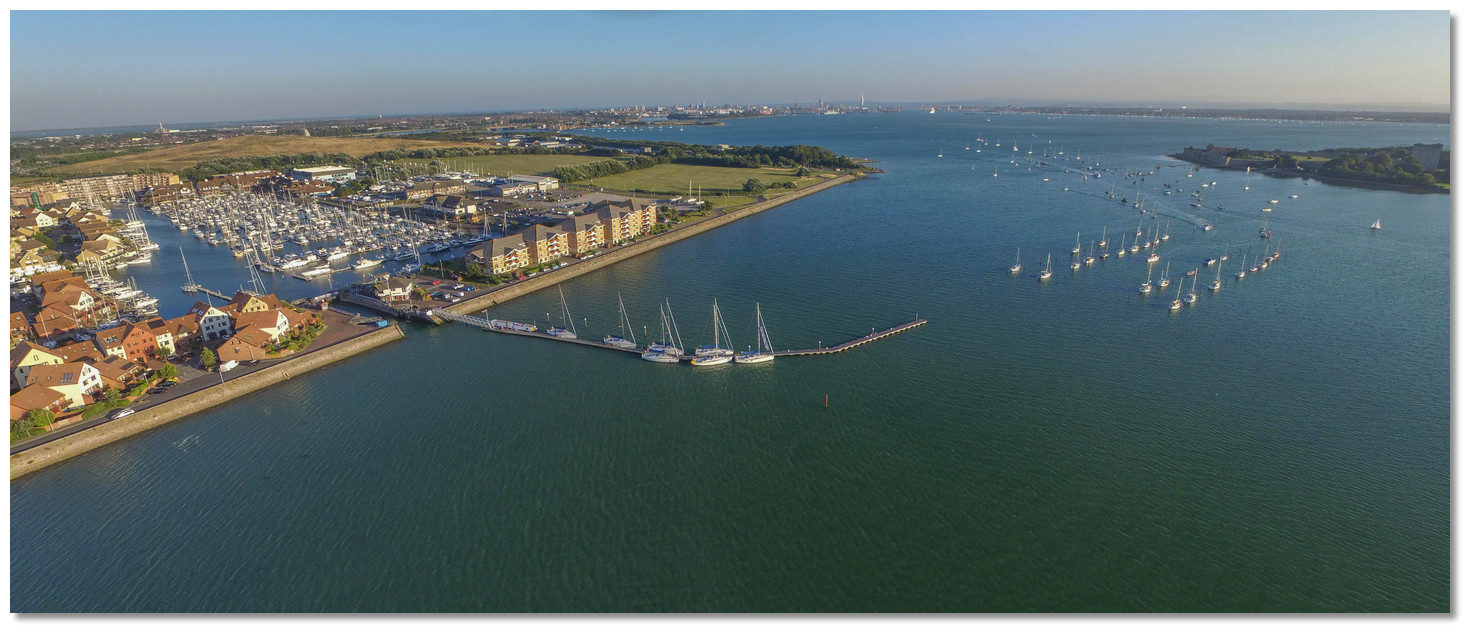
 Port Solent
Image: Michael Harpur
Port Solent Marina is located to the northeast corner of Portsmouth Harbour about 4 miles above its entrance and ½ mile northeast of the historic Portchester Castle. It is a purpose-built self-contained complex that offers a wide range of yachting and leisure facilities including shops, restaurants, a health centre and a large cinema.
The marina, which is entered through a lock 9.1 x 43 metres in dimensions and is available 24 x 7, has 900 berths and can accommodate yachts of up to 24 metres in length and 3 metres draught. Approaches through Portchester Lake has depths of from 4 to 9 metres at its entrance, shoaling gradually to 1.8 metres southward of Portchester Castle. From east of Portchester Castle, the channel is dredged to a minimum depth of 1.5 metres through to Port Solent Marina’s lock.
Port Solent Marina holds no specific visitor berths and accommodates visiting yachts on the berths of resident holders who are away. It is therefore advisable to make berthing arrangements in advance by contacting the reception on VHF Channel 80 or P: +44 23 92 210 765. The Marina Reception may also be contacted by email for berthing enquiries E: portsolentberths@premiermarinas.com or general enquiries E: portsolent@premiermarinas.com
The channel to Port Solent Marina is well-marked by closely spaced numbered beacons, some of which exhibit lights. A sharp watch should be maintained at night for large-scale unlit naval mooring buoys and yacht moorings in the channel.
How to get in?
 Port Solent and its approaches through Portchester Lake
Image: Michael Harpur
 The Solent and Isle of Wight coastal description provides approach details. Approaches to Portsmouth Harbour and its entry can be found in the Gunwharf Quays Marina entry. From the Ballast Bank Beacon continue northward along the western side of the harbour until it widens out and merges into the Fareham and Porchester lakes.
 The entrance to Portchester Lake, which is about a mile north of the harbour entrance, is marked to the west by the red pile No.57, Fl (3) R 5s, that should be left to port, and to the east by green pile No.95, Q.G, that should be left to starboard. Both these piles are substantial and visible at 3.2 miles. From here Portchester Lake extends northeast for a mile to where it bends northwest for a ⅓ of a mile before continuing north into Paulsgrove Lake. Portchester Lake has ample water throughout for leisure craft but shoals towards its head where it connects to Paulsgrove Lake and is dredged to 1.5 metres up to the Port Solent lock. The channel through Portchester Lake and Paulsgrove Lake, for about 2¼ miles to Port Solent Marina at its northern limit, is marked from seaward by red piles to the west, numbered 57 to 74, passed to port, and by green piles to the east running from 95 to 75, passed to starboard. At night twenty of the piles are lit but they may be difficult to identify owing to the high degree of background lighting. None should be approached too closely as many of the piles are on edge of the mud banks.
Within the entrance to Portchester Lake there are two unlit spherical yellow buoys, lying to the north of a second starboard pile within No. 94. These mark foul ground and should be left to starboard. This southern reach of the channel is deep and 250 metres wide with the best water defined by leaving the large unlit craft mooring buoys to port. At night this reach of the channel is clearly defined by southern lit starboard hand piles No’s 93, 92, 90, 88 and 86.
 Yachts navigating the well marked channels of Portchester Lake
Image: Nick via CC BY-SA 2.0
At pile No. 86 Fl (3) G. 10s the channel narrows and bends northward. The easiest path by day is to follow the port marks commencing at red port pile No. 63. At night steer pass south of red port pile No. 63, Fl.R.5s, for the starboard pile No. 86, Fl (3) G.10s, to avoid the arch of the mud bank and then round up to follow the three lit port-hand piles No. 66, No. 67 and No. 68. This also serves to stand clear of the entrance to Tipner Lake, an opening on Portchester Lake’s eastern side, that is marked by two piles yellow / black No. 82 and green No.85 and which can cause confusion.
Firing from the Tipner Range crosses the channel between port piles 63 through 67, and starboard piles 70 through 80, the limits of which are marked by notice boards. Red flags fly when in use but no restrictions are placed on the right to transit as firing practice only takes place when the area is clear of all vessels. When operational, vessels should transit quickly and not stop or linger in this firing area.
Beyond red port pile No. 68 Fl (4) R.10s, and the green starboard pile No. 80, Fl (4) G.10s, the channel narrows, turns north and is made further obvious by small craft moorings on either side.
The final section of channel leads past the conspicuous Portchester Castle. A ¼ of a mile southeast of the castle, at starboard pile No. 78, LFl.G.10s with an instruction sign on the pile, the marina should be notified of a vessels berthing intentions and a lock request should be made via VHF Ch. 80 call sign [Port Solent] or P: +44 23 92210765. Follow the instructions of the Lock Master and monitor Ch.80 for the final ¾ of a mile to the lock.
 The final approaches to Port Solent's waiting pontoon
Image: Michael Harpur
Continuing north Portchester Castle comes abeam passing, close to port of red port pile No.72A where the 1.5 metres deep dredged channel commences. The dredged channel then continues between lit piles port pile No.72, Fl (3) R.10s, and starboard pile No.76, Fl G.5s, with the best water immediately adjacent to starboard pile No.76.
 Yacht approaching Port Solent through Paulsgrove Lake
Image: Matt Buck via CC BY-SA 2.0
At starboard pile No.75, Fl (2) G.5s, the channel passes between rows of piled yacht moorings. Above this port piles A Fl(4) R.10s and starboard pile B Fl (3) G.10s mark the end of the outer waiting pontoon, starboard side on. The long and deep outer waiting pontoon can be fully occupied by Sunsail charter yachts who are more than happy to accommodate a waiting vessel by moving up, to provide space, or allowing for a temporary raft up.
 Port Solent's outer waiting pontoon
Image: Michael Harpur
Enter the lock under the instruction of the Lock Master; by VHF or loudspeaker. Red, stop, and green to proceed, traffic lights on the signal poles control access through the lock. The lock has some free flow around high water that is indicated by a flashing orange light when vessels can freely transit the lock if there is no other vessel transiting.
 Yachts exiting Port Solent Marina's lock
Image: Michael Harpur
Vessels will be asked to enter the lock on the green light or, during peak periods when a ‘queue’ number system is operating, when the assigned ‘queue’ number is called. All vessels should enter the lock with fenders on both sides and go as far forward as possible or as directed by staff.
 Port Solent's Lock
Image: Michael Harpur
Berth as instructed by the Lock Master whilst passing through the lock.
Why visit here?
Port Solent is a developed area in the northeast corner of Portsmouth Harbour, comprising a marina and luxury housing estate. The development is located on the western side of Horsea Island and was built in the 1980s on reclaimed land.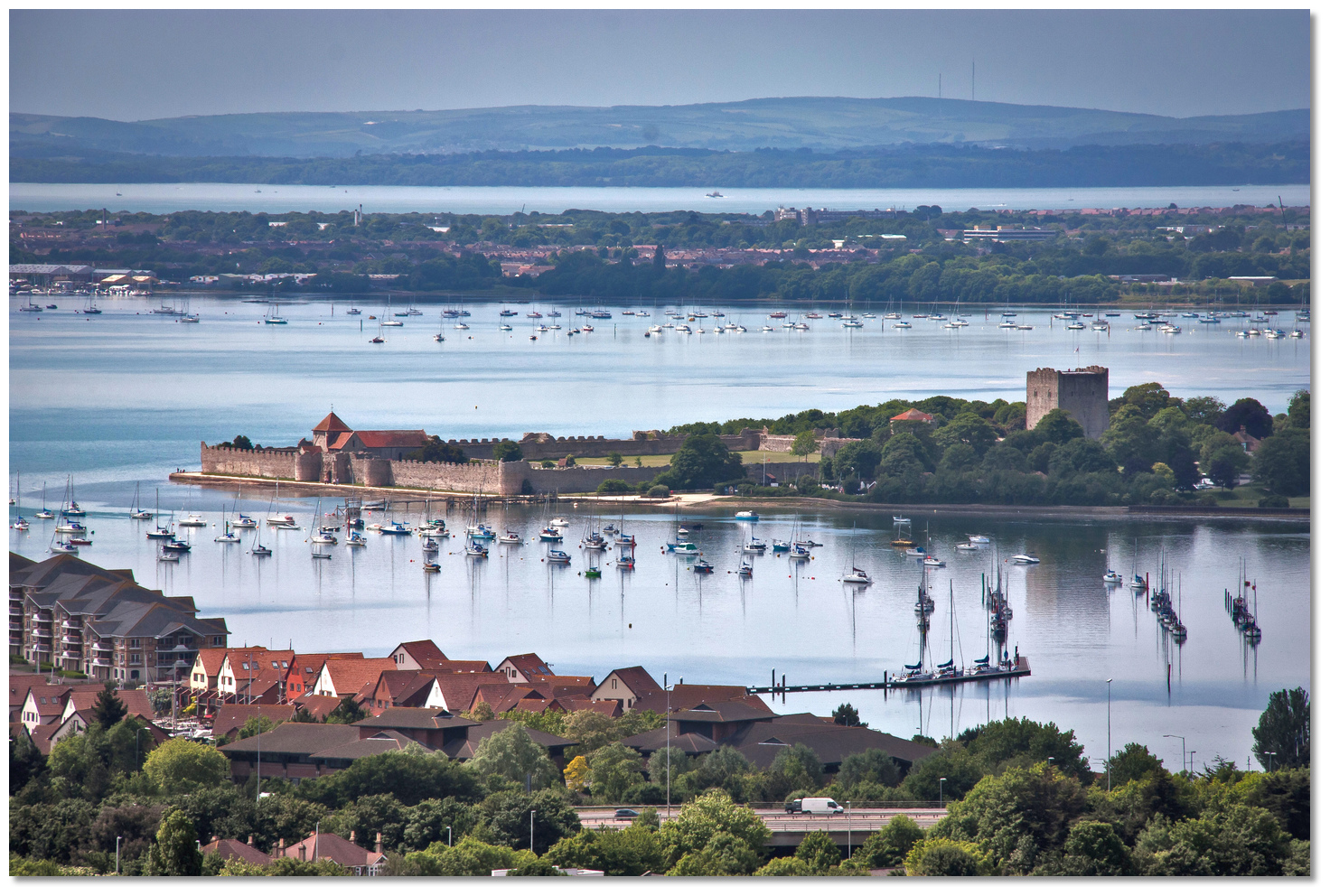 Port Solent Marina is overlooked by the magnificent Portchester Castle
Image: Mark Robinson via CC BY-NC 2.0
Although Port Solent is a thoroughly modern complex, it is overlooked from the opposite side of Paulsgrove Lake by the magnificent Portchester Castle which is steeped in history. First recorded as Porteceaster in 960, and Portcestre in the 1086 Doomsday survey, the area’s name is made up of the conjunction of the Latin words of port, more precisely portus that means 'a harbour', and ceaster, derived from castrum, meaning ‘fortified place’; thereby ‘Roman fort by the harbour called Port’.
 Carausius coin from Londinium mint
Image: Classical Numismatic Group via CC BY-SA 3.0
Roman shore forts also functioned as fleet bases and Porchester was no doubt servicing a fleet based in the perfectly protected waters of Portsmouth Harbour. Most likely this was the primary fleet base for the Roman galleys of the ‘Classis Britannica’, the fleet that guarded Britain. So, historically, this part of the harbour area was no backwater but the area’s epicentre which would have attracted a large amount of water traffic of both military and civilian nature.
 Portus Adurni with Classis Britannica galley
Image: Public Domain
The Normans were responsible for introducing a new defensive ‘castle’ concept with monastic foundations, large complexes of stone buildings and extensive estates. It was they who transformed Portchester Castle during the 12th century into a medieval castle that is seen today. The circuit walls of the fort became the outer bailey wall of their castle, and later a medieval palace. The monarchy controlled the castle for several centuries and it was a favoured hunting lodge of King John. The large natural harbour, providing a safe anchorage, was often used as a landing place and muster point for fleets of ships and armies, using Portchester as the point of landing or embarkation. Several French campaigns led by England's kings set out from these walls.
 Portchester Castle's outer bailey from the keep
Image: Charles Miller via CC BY-SA 2.0
It was likewise a target for French attack and the castle was besieged and captured by the French in 1216 before permanently returning to English control shortly thereafter. In anticipation of a French invasion during the first quarter of the 14th century, Edward II spent £1,100 repairing and reinforcing the castle. In 1415, while Henry V was at Portchester a conspiracy, known as the Southampton Plot, to overthrow him was discovered and the culprits apprehended at Portchester. The event features in Shakespeare's play, Henry V.
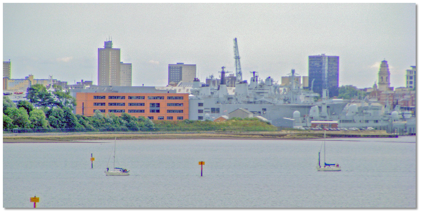
But in the 15th century, the town of Portsmouth grew to become a significant economic centre and an important port. Its role may have been enhanced by the gradual silting up of Portsmouth Harbour, making it difficult for larger ships to reach Portchester. Whatever the case, it took over from Portchester as a place of military importance, and the castle entered a period of decline. By 1441 Portchester Castle was described as being in a ruinous state and by 1500 it was a total ruin. In 1521 Henry VIII paid £400 for the construction of a great naval storehouse at Portchester Castle and the work was completed in 1527.
A century later in 1632 the castle passed out of royal control, and from the late 17th century onwards Portchester's most important function was that of a prison. Over the following centuries 18,000 French Prisoners of War were confined on hulks in the harbour, or at Portchester Castle. Those that died in captivity were often buried in what are now tidal mudflats to the south of the castle, their remains occasionally disturbed by storms.
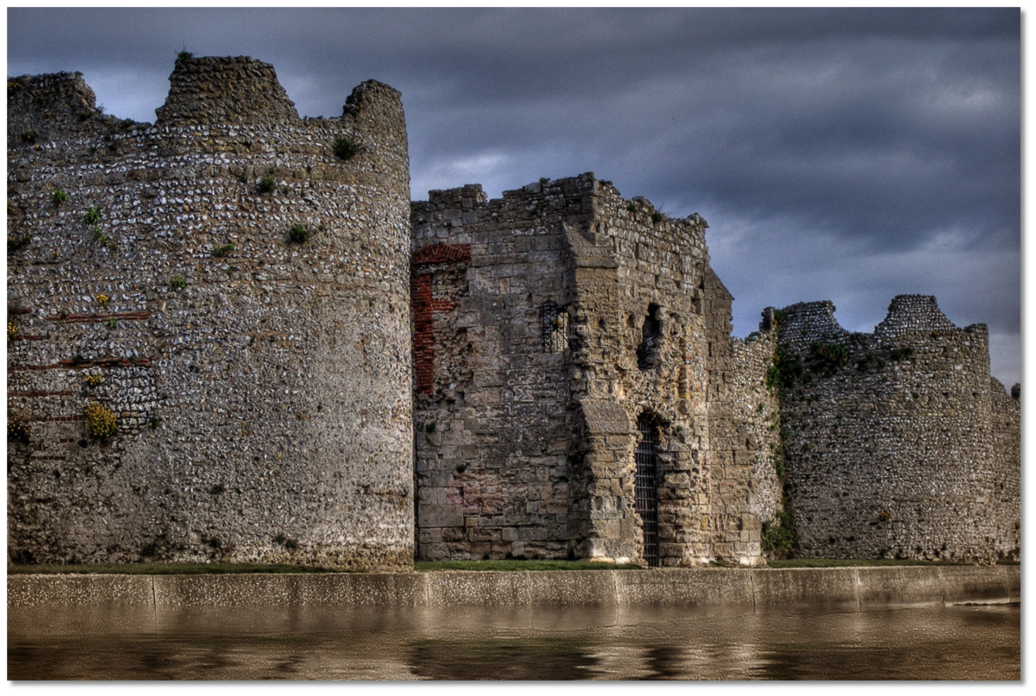 Portchester Castle's Norman walls stand largely intact to this day
Image: Scale Speeder via CC BY-SA 2.0
Today Portchester Castle is a Scheduled Ancient Monument, and a Grade I listed building. The castle has been in the ownership of the Southwick Estate since the 17th century but is managed by English Heritage and is open to visitors throughout the year. The Norman church, St. Mary's, which stands in the south-eastern corner of the grounds, falls within the Anglican Diocese of Portsmouth.
 Port Solent Marina
 Image: Michael Harpur
Port Solent Marina is owned and operated by Premier Marinas Limited based in Hampshire. The company owns and manages eight coastal marinas and boatyards in England offering berth holders freedom to roam between their facilities if space is available.
Occupying a commanding position that overlooks the marina the impressive castle provides the perfect setting for a relaxed, fun, historic day out for all the family. For more history of the area, a short train ride to Portsmouth, detailed in the Gunwharf Quay entry
, provides access to 800 years of naval history and a quick ferry ride from there, opens up several more days’ of historical exploration in Gosport, covered in the Gosport Marina entry .For those who just want to kick back and relax, the 21st century modern marina complex has lots for all the family to enjoy. Within its ground is a David Lloyd Health Club, a multiplex cinema, an eclectic mix of shops and a children’s playground. If you like to stretch your legs, there are also plenty of walks on the open land to the south of the marina. A visit to Port Solent provides access to both old and new in a highly protected part of the harbour.
What facilities are available?
Electricity and water are available on all the pontoons at Port Solent Marina. Overnight berthing includes free water and up to £2.00 of electricity. Additional credit is available from the Marina Reception. Contact the Marina Reception on VHF Channel 80 or call 02392 210 765 to arrange connection. Premier WiFi is available throughout the marina with the option to upgrade to Premier WiFi Plus for unlimited usage in a 24 hour period for up to 3 devices and VPN access. The Marina Reception also sells bags of ice during the summer.Diesel and unleaded petrol are available 24x7 at the fuel bay, starboard side immediately within the entrance. The fuel pontoon is open 0800-2000 in the summer and 0800 –1800 in the winter and it is recommended that a call be made to VHF Ch.80 before heading for the fuel bay. Gas cylinders are also available. Pump-out facilities are available at the fuel bay with 24 hours’ notice normally required. A coin operated launderette can be found on the ground floor of the Port House where there is an iron and board. Port Solent Marina offers full recycling facilities onsite with waste disposal areas located near each bridghead.
The marina has a fully serviced boatyard that includes two hoists – a 40 tonne travel hoist and a 1.8 tonne jib crane. There is a chandler, several marine electronic outlets onsite and a wide range of specialist services from rigging to marine electronics, GRP repairs and cosmetic work, and engineering. There is a choice of restaurants, bars, cafes, a health centre and a cinema surrounding the marina complex. Excellent provisioning is available at the Tesco Extra within 10 minute’s walking distance on the perimeter of the complex. Portsmouth is just 18 minutes away by train from the local Portchester station.
Any security concerns?
CCTV cameras cover berths, car parks, bridgeheads, and the shoreside. There are also 24-hour security patrols. Each pontoon bridgehead has an access control system activated by a programmed fob.With thanks to:
Michael Harpur S/Y Whistler. Photography with thanks to Michael Harpur, geni and Matt Buck.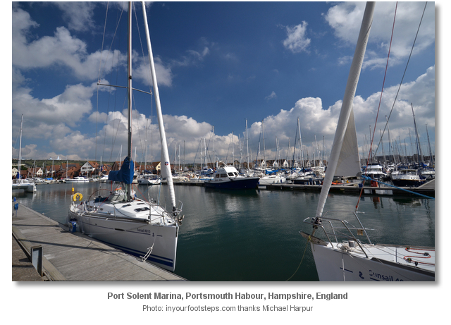


Port Solent Marina


Add your review or comment:
Sheila King wrote this review on May 20th 2018:
It would be worth mentioning Portchester Sailing Club which is based immediately to the north of the Castle and has moorings just outside Port Solent Lock. The website for PSC has information.
Average Rating: UnratedMichael Harpur wrote this review on May 21st 2018:
Hi Sheila,
Thank you for that suggestion. I have just added it in. Many many thanks
Nicholas Pearson wrote this review on Sep 6th 2019:
What a full description, thank you. Just one comment one picture is named entrance to Port Hamble it should be Port Solent? we are visitit the Marine tonight (Friday 6th) hence the view of the wed page- Regards Nick
.
Michael Harpur wrote this review on Mar 26th 2020:
Thank you so much Nicholas, for your kind words and your correction. Any other issues here on any other page please do let us know as we are delighted to make corrections.
Average Rating: UnratedRoger Higgs wrote this review on Jul 14th 2020:
Michael, this is a truly beautiful website, thank you. Are you the artist who drew the magnificent reconstruction of "Portus Adurni with Classis Britannica galley"? I should like to refer to it properly in an academic paper that I am preparing, on sea level in Roman times. With thanks and kind regards, Roger
Dr Roger Higgs
rogerhiggs@hotmail.com
Michael Harpur wrote this review on Jul 15th 2020:
Hi Roger,
My apologies te image we found as a public domain image somewhere. When I post to the site it automatically credits an image to me unless I provide an alternate credit, and in this case, I just accidentally forgot to do that. No great artist here I am afraid, worse, it is case of me hitting return to early.
Roger Higgs wrote this review on Jul 15th 2020:
Thanks Michael. Not to worry. If you ever find the original source I'd love to know who drew that lovely picture. I look forward to exploring the rest of your website. Please keep up the great work. Makes we wish I was a sailor! I'm 66. It's never too late, right? Regards, Roger
Average Rating: UnratedPlease log in to leave a review of this haven.
Please note eOceanic makes no guarantee of the validity of this information, we have not visited this haven and do not have first-hand experience to qualify the data. Although the contributors are vetted by peer review as practised authorities, they are in no way, whatsoever, responsible for the accuracy of their contributions. It is essential that you thoroughly check the accuracy and suitability for your vessel of any waypoints offered in any context plus the precision of your GPS. Any data provided on this page is entirely used at your own risk and you must read our legal page if you view data on this site. Free to use sea charts courtesy of Navionics.