

Often used as a tide-wait location for the drying channel to the harbour this location also provides a good anchorage of itself. Although a half mile offshore it is well protected from south round to west. Approaches are straightforward as a lit large fort, close south, makes a very good identifying mark from seaward and Bembridge's Light-beacon also exhibits a light at night. There are no hazards to an eastern approach and it may be accessed at all stages of the tide.

Keyfacts for St Helens Duver
Facilities


Nature


Considerations
Protected sectors

Approaches

Shelter
Last modified
August 24th 2018 Summary
A good location with straightforward access.Facilities
Nature
Considerations
Position and approaches

Expand to new tab or fullscreen
Haven position
 50° 42.410' N, 001° 5.190' W
This is on the 2 metre contour ½ out from the shore in about the middle of the bay.
What is the initial fix?
The following Bembridge Initial Fix will set up a final approach:
 50° 42.468' N, 001° 5.016' W


What are the key points of the approach?
The entry and the run-up thorough The Solent and Southampton Water are covered in
The Solent and Isle of Wight coastal description. Approaches are covered in the adjacent Bembridge Harbour
  entry. Vessels converging on the entrance will find nothing in the way of local hazards by staying in reasonable soundings and following the marks.
The Solent and Isle of Wight
coastal description. Approaches are covered in the adjacent Bembridge Harbour entry. Vessels converging on the entrance will find nothing in the way of local hazards by staying in reasonable soundings and following the marks.- From the Bembridge light beacon proceed westward feeling about with the depth sounder.
- Anchor according to draft in sand.
Not what you need?
Click the 'Next' and 'Previous' buttons to progress through neighbouring havens in a coastal 'clockwise' or 'anti-clockwise' sequence. Below are the ten nearest havens to St Helens Duver for your convenience.
Ten nearest havens by straight line charted distance and bearing:
- Priory Bay - 0.3 nautical miles NNW
- Bembridge Harbour - 0.9 nautical miles SW
- Seaview - 1.2 nautical miles NNW
- Whitecliff Bay - 2.3 nautical miles S
- Ryde Harbour - 3 nautical miles WNW
- Ryde Roads - 4.2 nautical miles WNW
- Sandown Bay - 4.4 nautical miles SW
- Wootton Creek (Fishbourne) - 5.1 nautical miles WNW
- Stokes Bay - 5.1 nautical miles NNW
- Haslar Marina - 5.2 nautical miles NNW
These havens are ordered by straight line charted distance and bearing, and can be reordered by compass direction or coastal sequence:
- Priory Bay - 0.3 miles NNW
- Bembridge Harbour - 0.9 miles SW
- Seaview - 1.2 miles NNW
- Whitecliff Bay - 2.3 miles S
- Ryde Harbour - 3 miles WNW
- Ryde Roads - 4.2 miles WNW
- Sandown Bay - 4.4 miles SW
- Wootton Creek (Fishbourne) - 5.1 miles WNW
- Stokes Bay - 5.1 miles NNW
- Haslar Marina - 5.2 miles NNW

Chart

How to get in?

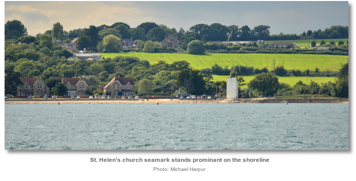
St Helens Duver lies close northward of the easternmost point of the Isle of Wight, ¾ of a mile northward of Bembridge Point, ½ a mile out from Nodes Point and to the north of the drying area west of St Helen’s Fort. It is at the entrance to the Bembridge Harbour approach channel ¾ of a mile northeast of the harbour's mouth.
The shoreline has a ledge to which the bay gradually shelves and dries a ⅓ of a mile from Node’s Point. This pushes the anchorage's 2 metre contour about a ½ mile out from the shore.
 Use details provided for the adjacent Bembridge Harbour for approaches. Keep watch for the odd lobster pot that may be encountered around this area.
 The Bembridge initial fix is the position of the Bembridge Approach Light-beacon. It is located 400 metres northward of the conspicuous St. Helen's Fort which although the smallest of the 1860 Palmerston forts, makes itself readily known for many miles to seaward.
From the light beacon proceed westward feeling about with the depth sounder towards the area close north of the first of Bembridge’s channel marker buoys. The sands shift tend to drift here so rely on the soundings over chart contours in this position. Saint Helen's Church, a white seamark, will be seen on the shore on a bearing of about 235° T.
 Anchor according to draft. The holding is good in hard sand. Expect an occasional long frequent wash from large ships coming and going from Southampton and Portsmouth.
Land by tender on Duver Beach or within the harbour area.
Why visit here?
The area takes its name from the St Helens ‘Old Church’ that overlooks the anchorage. It was built on sand by Benedictine monks in the 14th century and dedicated to St Helena mother of the Roman Emperor Constantine, from which the village of St. Helen’s, overlooking Bembridge Harbour close south, also took its name. The church was washed away by storms after the river had changed course and the land was claimed by the sea. The remains of the bricked up tower was reinforced in 1703 and painted white to act as a sea-mark to aid shipping and it has remained as such to the present day. Duver, pronounced ‘duvver’, is the local Isle of Wight name for a stretch of sand by the sea.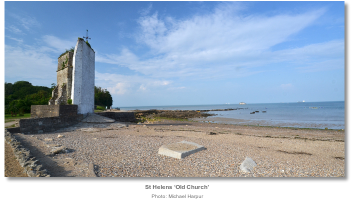
St Helens Duver, and Saint Helens Road further out to sea, have provided good anchorages for generations of Royal Navy ships. A poignant plaque on St. Helen’s Old Church tower marks the fact that in 1805 Lord Nelson boarded HMS Trafalgar just off the Duver on his way to that fateful battle at Trafalgar. It was for the protection of this anchorage that St. Helens Fort, the anchorage’s other and most prominent feature, was constructed. The fort was built as part of a group of Victorian period forts and associated defensive structures called the Palmerston Forts. The structures were erected on the recommendation of the 1860 ‘Royal Commission on the Defence of the United Kingdom’ following concerns about the strength of the French Navy.
The 1815 Battle of Waterloo brought peace to Europe for more than three decades, but in 1848 a second republic was declared in France and Louis Napoleon became its first president as Napoleon III. The introduction of advanced artillery and steam-driven iron ships had all but obsoleted the Royal Navy and caused near panic in England. The commission ordered a huge programme of fortification to defend the country's arsenals and naval bases due to the doctrines of the ‘Jeune Ecole’. This was a new French naval approach that emphasised attacking ports with small craft, instead of fleet action, but was also backed by their first ironclad battleship. England was suddenly vulnerable again and steps had to be taken. Palmerston, the Victorian prime minister, pushed through the large scale construction in the face of bitter opposition.
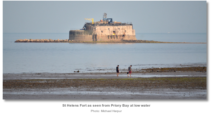
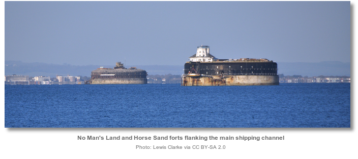
Four new sea forts were built in the eastern approaches to The Solent as part of the project; Spit Bank Fort near Portsmouth as well as the two centrally located Horse Sand and No Man's Land forts which flank the main shipping channel into the Solent, and St Helens Fort. A Ryde Sand fort was planned but abandoned because the sands could not support the requisite foundations. St Helens Fort, the smaller of the four forts, was built between 1867 and 1880 and suffered badly from subsidence which forced many changes to its design. It ended up with two 10-inch 18-ton rifled muzzle-loading (RML) guns to landward and one 12.5-inch 38-ton RML gun to seaward. It protected the St Helens Road anchorage whilst the remaining forts were intended on protecting Portsmouth dockyard.
The forts all vastly overran their budgets as a result of complications surrounding their 6 to 9 metres below sea level foundations. The cost of the total combined defensive uplift escalated to one million pounds, three times what it would have cost to build land forts, and was so out of control that Gladstone, the then chancellor, threatened to resign. This price alongside the zeal with which the prime minister pushed through the construction, set the stage for these forts to become known as Palmerston's Follies. This was, in a large part, due to the first Portsmouth forts having their main armament facing inland to protect Portsmouth from a land-based attack. This gave the general public the unfortunate impression that they faced the wrong way to defend from a French attack.

St Helen’s fort is now owned by the local authority but not open to the public. Periodically, most often in August, on one of the lowest tides of the year, there is a mass walk from St Helens beach out to the fort and back. During these very low spring tides the original causeway used to construct the fort reappears along the seabed. This leads out from St Helen's Old Church which was the quarry site from which the fort’s original materials were obtained. The walkout is entirely spontaneous but safety boat services are informally provided by local Bembridge yacht clubs. After the walk, a barbecue is traditionally held immediately ashore on Duver beach which is overlooked by St Helen’s Old Church.

St Helen’s Duver was formed by sea currents depositing sand and shingle at the mouth of the river Yar over the centuries. In 1882, the Royal Isle of Wight Golf Club was established on this spot, one of the very first golf courses in England. The club closed in 1961/2 and gifted its grounds to the National Trust. The low-lying sandy spit of short turf and gently undulating ground is today the most important dune grassland on the Island. It is renowned for its rich flora during the summer months especially its bright displays of thrift in May.
The anchorage here is predominantly used as a tide-wait location but is a very serviceable general purpose anchorage albeit somewhat out from the shoreline. Immediately ashore it has The Baywatch Café seafood restaurant, just inshore of marker buoy number 6A in the approach channel to Bembridge Harbour. It offers local crab, lobster, and sea bass, and has fine views of the boats at anchor offshore. A wonderful family beach stretches from the café to the entrance to the harbour which has public toilets. The village of St Helens is within an easy walk through the Duver, as is Bembridge across the harbour, which may be reached by a water taxi service from the Duver. Alternatively Bembridge and St Helens are accessible by entering the harbour and landing from a dinghy.
What facilities are available?
There is nothing on this shoreline apart for the Baywatch cafe that overlooks the anchorage. Many more facilities are available within the harbour.Any security concerns?
Never an issue known to have occurred to a vessel anchored off the approach channel to Bembridge.With thanks to:
Michael Harpur

Aerial view of the Duver in Bembridge
Aerial view of St. Helens Fort, Duver, Bembridge and the channell at low water


Add your review or comment:
Please log in to leave a review of this haven.
Please note eOceanic makes no guarantee of the validity of this information, we have not visited this haven and do not have first-hand experience to qualify the data. Although the contributors are vetted by peer review as practised authorities, they are in no way, whatsoever, responsible for the accuracy of their contributions. It is essential that you thoroughly check the accuracy and suitability for your vessel of any waypoints offered in any context plus the precision of your GPS. Any data provided on this page is entirely used at your own risk and you must read our legal page if you view data on this site. Free to use sea charts courtesy of Navionics.