

Located within a river and off Southampton Water, the pontoon offers good protection. It can be subject to an uncomfortable fetch in conditions of over Force 5 or more from the southeast. The approaches and pontoon can be safely accessed night or day, at any state of the tide and in all reasonable conditions.


Keyfacts for Marchwood Yacht Club
Facilities


Nature


Considerations


Protected sectors

Approaches

Shelter

Last modified
July 17th 2018 Summary
A good location with safe access.Facilities
Nature
Considerations
 +44 2380 666141
 marchwoodyc.org.uk/mycxtra/
Position and approaches

Expand to new tab or fullscreen
Haven position
 50° 54.153' N, 001° 26.491' W
This is the northeast point of the hammer head.


What are the key points of the approach?
The entry and the run-up thorough The Solent, Southampton Water and River Test are covered in
The Solent and Isle of Wight coastal description.
The Solent and Isle of Wight
coastal description. - Enter the River Test by passing Dock Head to starboard.
- Proceed 2½ miles upriver beyond the cruise liner docks maintaining a careful watch for ferry and ship movements.
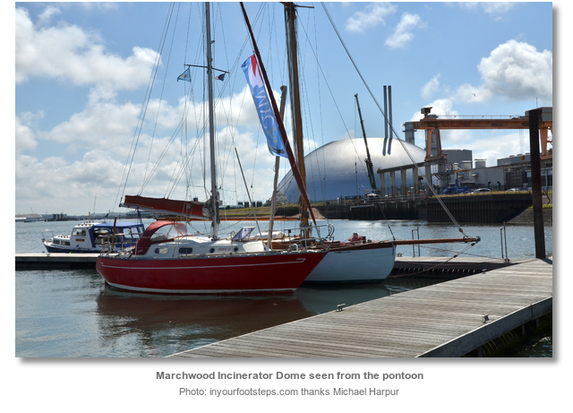
- The pontoon will be found on the southwest bank of the River Test close westward of the prominent Marchwood incinerator dome.
Not what you need?
Click the 'Next' and 'Previous' buttons to progress through neighbouring havens in a coastal 'clockwise' or 'anti-clockwise' sequence. Below are the ten nearest havens to Marchwood Yacht Club for your convenience.
Ten nearest havens by straight line charted distance and bearing:
- Town Quay - 1.5 nautical miles ESE
- Eling - 1.6 nautical miles WNW
- Ocean Village Marina - 2 nautical miles ESE
- Hythe Marina Village - 2.3 nautical miles SE
- Shamrock Quay - 2.3 nautical miles E
- Saxon Wharf Marina - 2.5 nautical miles ENE
- Kemps Quay - 2.5 nautical miles ENE
- Netley - 4.6 nautical miles SE
- Universal Marina - 5.3 nautical miles ESE
- Mercury Yacht Harbour - 5.4 nautical miles ESE
These havens are ordered by straight line charted distance and bearing, and can be reordered by compass direction or coastal sequence:
- Town Quay - 1.5 miles ESE
- Eling - 1.6 miles WNW
- Ocean Village Marina - 2 miles ESE
- Hythe Marina Village - 2.3 miles SE
- Shamrock Quay - 2.3 miles E
- Saxon Wharf Marina - 2.5 miles ENE
- Kemps Quay - 2.5 miles ENE
- Netley - 4.6 miles SE
- Universal Marina - 5.3 miles ESE
- Mercury Yacht Harbour - 5.4 miles ESE

Chart

How to get in?

Marchwood Yacht Club is located on the southwest side of the River Test, which is entered from the head of Southampton Water, and lies opposite the northeast end of Southampton’s Western Docks. The club is located a ½ mile northward of the small village and civil parish of Marchwood that lies between Totton and Hythe and directly east of the New Forest.
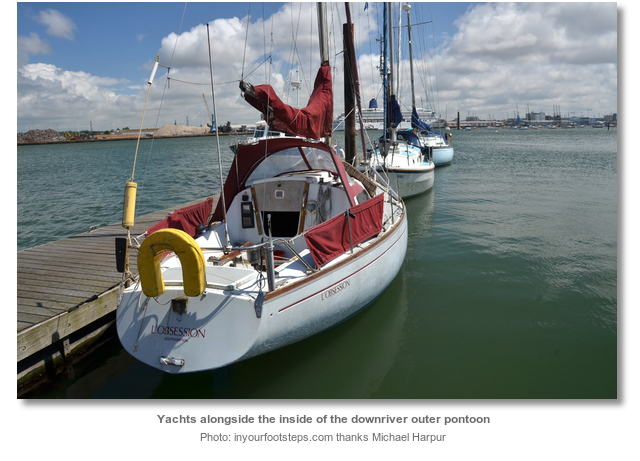
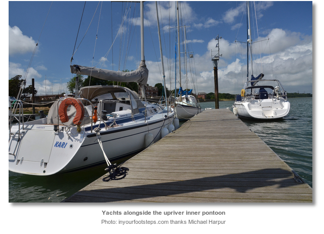
The club actively welcomes visitors to its ‘H’ shaped pontoon. The River Test is dredged to 13.2 metres as far as Marchwood. The pontoon can take about 20 boats and provides a range of depths from 3 metres on the outmost berth, to a drying berth on the innermost faces of the pontoon. Alternative arrangements can be made to accommodate vessels on moorings should berths on the pontoon be overwhelmed.
Though not necessary it is best to contact the club a couple of days in advance of any intended visit. Enquires can be made to the Clubhouse on P: +44 2380 666141. Yacht Clubs wishing to book a visit or regatta should use Marchwood Yacht Club’s contact page to make arrangements. Mooring fees are a flat fee of £10.00 per day for each boat irrespective of length. The maximum stay available is a total of 3 days. It is a club requirement that no boat should be left unattended overnight.

 The Solent and Isle of Wight coastal description provides approach details. Vessels will find nothing in the way of local hazards by staying in reasonable soundings and following the ample marks.
Continue past Town Quay for a further 1½ miles upriver to the club pontoon. Beyond Town Quay the river is dominated by large container docks on its northeast shore and industrial docks to the southwest. Amongst the latter is a large silver dome that will have been clearly visible from Southampton Water. This is the dome of the Marchwood incinerator that is located 300 metres to the southeast of the pontoon and provides a prominent landmark for its position.
Maintain a careful watch for ships manoeuvring off the Western Docks using the turning circle close northwest of Town Quay, or the turning circle close north of the club pontoon, whilst proceeding up from Town Quay. There is ample water close outside the ‘Cracknore’ port hand buoy Oc. R. 8s and series of ‘Swinging Ground’ port marks should a vessel encounter a manoeuvring ship.
At high water there is the option to step out of the deep water channel and into The Marchwood Channel, opening to the south ‘Cracknore’, to evade ships and take advantage of a slight cut. Marchwood Channel’s depths range from 2.3 metres to 3.2 after Marchwood Basin. Its western end however has as little as 0.4 metres LAT and is full of Marchwood Yacht Club moorings that a transiting vessel has to worm its way through.
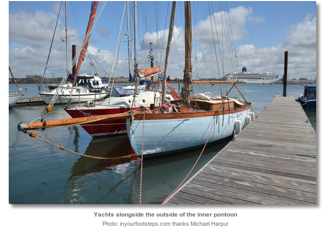
 Berth alongside the club’s ‘H’ shaped pontoon. The outer hammerhead has 3 metres and its inside has 2.5 metres on LWS. The inner pontoons outer face has 1 metre and its inner side dries on LWS. However the inside of the inner pontoon can have as much as 1.5 metres at low water neaps over soft mud.
When rafting up, vessels should make certain to offset masts as the tugs assisting turning ships in the adjacent turning circle can cause considerable wash. The clubs appointed berthing ‘Officer Of the Day’ will be delighted to take any questions.

Why visit here?
It is believed ‘Marchwood’ is derived from Old English ‘merece’ combined with ‘wudu’. This mean ‘wood where the smallage grows’. ‘Smallage’ in this context was a term used for wild celery. Its first mention in the 1086 Domesday Book was as ‘Merceode’ where it was noted that its manor was held by Alwin who had received it from his father Wulfgeat in 1066.During Norman times the area was part of the hunting grounds of King William II, also known as Rufus, who stayed at a hunting lodge near Berry Farm. Later the area was infamous for smuggling, with cargoes being landed at Cracknore Hard and run up to Exbury for auction. Beacon Hill acquired its name in Elizabethan times when it was the site of an important warning beacon that received and sent messages to both ends of the Isle of Wight. It was one of the national chain of beacons which warned the nation that the Spanish Armada had been sighted coming up the Channel. But it was to be Cracknore that would see the first development of the shoreline. It became the landing place where the Southampton ferry was established long before the Hythe ferry had started in 1575. The site of the Marchwood Yacht Club was however the first substantive and nationally important development to come to these shores.
This was the site of the Royal Naval Armaments Depot than opened in 1815 as a gunpowder store. Like Tipner, in Porstmouth, the depot was a sub-depot of Gosport’s Priddy’s Hard. Priddy’s Hard, now a museum, was first a fort and then an armaments depot for Royal Navy and British Army weapons, explosives and other stores. It was the oldest of four depots making up the complex of Royal Naval Armaments Depots. Priddy’s Hard had the capability to store 6,000 barrels of gunpowder, but it was necessary to disperse the gunpowder in case the depot ever came under attack. The Marchwood depot initially consisted of three magazines, each with a capacity to store 6,800 barrels of gunpowder. It has a small internal L-shaped channel for moving the barrels by barge and a centrally-placed Shifting House. This was fronted by a rolling stage, featuring a raised planked barrow way that went out to a landing stage in deep water. The rolling stage was later replaced by an iron pier structure.

The Military Port was developed for the assembly and launching of the famous Mulberry harbours used to support the D-Day landing on the Normandy beaches the following year. It went on to support the occupying forces following the success of the landings. The port played a vital role in the snap Falklands War of 1982. It was here that the expeditionary equipment and troops were quietly loaded onto the ships for transit to the conflict zone. The port originally had one pier which after the Falklands War was significantly upgraded to three main jetties. It is now the sole remaining active military port in the United Kingdom. However reports of a sale to a private operator emerged in 2010 but no firm decision has been made. The port continues to service Britain's overseas military interests.
But that is not the case for the Royal Naval Armaments Depot that by 2010, had already been closed for almost half a century. Stocks of munitions were reduced after the war and in the late 1950s the Navy began to cut down on the size of the Fleet. Weaponry had also become more refined and the location of Marchwood had become geographically unsuitable. The site was finally decommissioned and closed in 1961.
The Marchwood Yacht Club pontoon offers an interesting berth on the River Test. Deep, accessible at all stages of the tide, night and day, effectively priced and with a very welcoming club it has a lot going for it. Its site on a Georgian military works of national importance is a relatively rare piece of history to experience. The two small lodge-type buildings, the office and guardhouse occupied by Marchwood Yacht Club, date from the original site development of 1814. One building is now the bar and restaurant, the other the Committee rooms. It is very unusual to have club facilities that go back to the Napoleonic wars. For those who have an interest in shipping, there is no better place to observe them closely, when they are being turned in the turning circle off the pontoon.
What facilities are available?
Water taps are located at the two ends of the central pontoon but no electricity. There are bottle banks and waste bins by the main entrance to the club.The club bar normally opens during lunchtime, 12 to 2 pm on Saturday and Sunday and from 8 pm on Tuesday, Friday and Saturday nights but times may vary. The club’s restaurant offers very good food and is normally open during lunchtime for light meals and sandwiches. In the evening it has a set menu along with a number of specials of the day. The restaurant can be contacted on P: +44 23 8034 3094 or M: +44 77 0656 2583.
The nearest fuel bunkers are at Hythe Marina, or Itchen Marine at American Wharf. Marchwood, about three quarters of a mile’s walk from the club, has a small parade of shops in the village centre next to the school which includes a grocers, a convenience store along with a chemist, a bakery, a post office and some pubs.
Any security concerns?
The club grounds, pontoon area and facilities are all secured via locked gates that are accessed by coded keypads located alongside the locks. The berthing ‘Officer Of the Day’ will be delighted to provide visitors with the code.With thanks to:
Barry and June Parker, Marchwood Yacht Club. Photography Michael Harpur.


Add your review or comment:
Please log in to leave a review of this haven.
Please note eOceanic makes no guarantee of the validity of this information, we have not visited this haven and do not have first-hand experience to qualify the data. Although the contributors are vetted by peer review as practised authorities, they are in no way, whatsoever, responsible for the accuracy of their contributions. It is essential that you thoroughly check the accuracy and suitability for your vessel of any waypoints offered in any context plus the precision of your GPS. Any data provided on this page is entirely used at your own risk and you must read our legal page if you view data on this site. Free to use sea charts courtesy of Navionics.