

Located within the natural harbour of Portsmouth it provides good protection but can be exposed to a large waterway in strong easterly conditions. Safe access is available in all reasonable conditions, during daylight hours.

Keyfacts for Hardway Sailing Club
Facilities


Nature


Considerations

Protected sectors

Approaches

Shelter

Last modified
July 17th 2018 Summary
A good location with safe access.Facilities
Nature
Considerations
 02392 581 875
 secretary@hardwaysailingclub.co.uk
Position and approaches

Expand to new tab or fullscreen
Haven position
 50° 48.887' N, 001° 7.916' W
This is the head of the Hardway Sailing Club Pontoon


What are the key points of the approach?
The entry and the run-up thorough The Solent and Southampton Water are covered in
The Solent and Isle of Wight coastal description. Approaches to Portsmouth Harbour and its entry can be found in the Gunwharf Quays Marina
  entry and the run up Fareham Lake is described in the Fareham Marina entry.
The Solent and Isle of Wight
coastal description. Approaches to Portsmouth Harbour and its entry can be found in the Gunwharf Quays Marina entry and the run up Fareham Lake is described in the Fareham Marina entry.Not what you need?
Click the 'Next' and 'Previous' buttons to progress through neighbouring havens in a coastal 'clockwise' or 'anti-clockwise' sequence. Below are the ten nearest havens to Hardway Sailing Club for your convenience.
Ten nearest havens by straight line charted distance and bearing:
- Royal Clarence Marina - 0.9 nautical miles SSE
- Gosport Marina - 1.2 nautical miles SSE
- Haslar Marina - 1.5 nautical miles SSE
- Gunwharf Quays Marina - 1.5 nautical miles SE
- WicorMarine Yacht Haven - 1.6 nautical miles NNW
- Port Solent Marina - 2 nautical miles NNE
- Stokes Bay - 2.4 nautical miles SSW
- Portsmouth Marine Engineering - 2.5 nautical miles NW
- Fareham Marina - 2.7 nautical miles NW
- Southsea Marina - 3.9 nautical miles ESE
These havens are ordered by straight line charted distance and bearing, and can be reordered by compass direction or coastal sequence:
- Royal Clarence Marina - 0.9 miles SSE
- Gosport Marina - 1.2 miles SSE
- Haslar Marina - 1.5 miles SSE
- Gunwharf Quays Marina - 1.5 miles SE
- WicorMarine Yacht Haven - 1.6 miles NNW
- Port Solent Marina - 2 miles NNE
- Stokes Bay - 2.4 miles SSW
- Portsmouth Marine Engineering - 2.5 miles NW
- Fareham Marina - 2.7 miles NW
- Southsea Marina - 3.9 miles ESE

Chart

How to get in?

Hardway Sailing Club fronts Hardway village, a suburb of Gosport, on the western side of Portsmouth Harbour. The club is located just under two miles from the harbour mouth where the inner harbour widens out and merges into the Fareham and Porchester lakes.
The club openly welcomes visitors to their pontoon. A flat rate of £10 is charged per day for up to seven days. Prices then rise to £22 per day to 28 days after which it becomes £44 a day.

 The Solent and Isle of Wight coastal description provides approach details. Approaches to Portsmouth Harbour and its entry can be found in the Gunwharf Quays Marina entry. The run-up Fareham Lake and approaches to Portsmouth Marine Engineering is described for Fareham Marina .
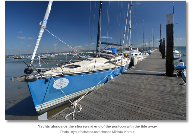
The clubhouse and pontoon are located at the southern end of Fareham Lake. Four pontoons will be seen along the shore fronting the village of Hardway of which the sailing club is the northern most. The first is the large ‘L’ shape ‘Vospers Jetty’. The second is ‘Sultan Landing’ used by launches to take vessels to Portsmouth moorings. Then there is a short 80 metre public pontoon close to the longer 250 metre long Hardway Sailing Club pontoons.
 The seaward pontoon has about 1.5 metres at neaps but almost dries at the bottom of large springs.
 Fin keel vessels can comfortably come alongside the inner pontoon at high water. The sea bed surrounding the pontoons is made up of a soft silt so vessels will comfortably sit into the mud as the tide falls away. Expect at least two metres of water at the inner most pontoon at high water.

Why visit here?
The name Hardway stems from providing a solid landing position in the shallow waters and mudflats of Portsmouth Harbour. The early settlement was known as ‘Elson Hardway’, or ‘Elson Hard’, up to the 18th century after which it became shortened to its present Hardway.
Portsmouth’s shoreline had a number of these historic ‘hards’. As late as the mid-nineteenth century charts noted as ‘Priddy’s Hard’, ‘Goliath’s Hard’, ‘Lower Hard’, ‘Pinney’s Hard’ and ‘Convict’s Hard’. Piers and quays now occupy many of the locations of these original hards. ‘Convict’s Hard’, as its name suggests, was used to transport convicts to prison hulks. Prison hulks were decommissioned ships, usually with their masts reduced or removed, that were used as floating prisons. Authorities used them in the 18th and 19th centuries to alleviate the pressure on prisons. They also served as a cheap alternative to building more prisons on land. Lines of these Prison Hulks were moored in the Thames, Langstone Harbour, and in Fareham Lake off Hardway.

Hardway’s history runs much deeper than this. Given its prominent position by the harbour and solid landing area it has had a long history of habitation. Villagers farmed the surrounding open land and fished the harbour but there is also evidence of a long history of boat building here. The settlement was historically somewhat isolated from Gosport by Forton Lake. In the latter part of the eighteenth century, following the relocation of the Royal Ordnance Depot from Portsmouth to Priddy’s Hard, the west end of Forton Lake was gradually reclaimed. This made Hardway more accessible and spurred its growth thereafter. Much of Hardway’s village character stems from the development in the 18th and 19th century that followed this.

Because Hardway provided a relatively sheltered location that avoided town traffic it specifically catered to the large ‘Landing Ship, Tank’s (LST), or tank landing ships. Of the 203 British and American LST’s involved in D-Day 192 of them had departed from Hardway. Many of these returned with wounded soldiers and prisoners to be reloaded and then returned to the Normandy beaches. It was not until six months after D-Day, when the Belgian port of Antwerp was captured, that the use of Hardway lessened. It continued nevertheless to load food and medicines destined for the starving people of Europe.

Hardway today is a quiet suburban suburban village made up of a few industrial estates, and two-storey residential housing built along a 19th century road plan. The character of the area, particularly from the foreshore, is dominated by its relationship to Portsmouth Harbour to which there are clear views.
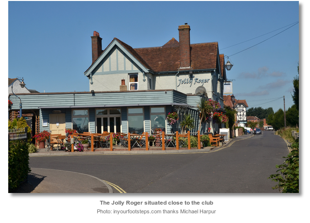
Hardway Sailing Club is a very friendly club that offers the budget sailor a very efficient Portsmouth Harbour berth that is nonetheless just a short walk, or ferry ride, from all the city attractions. It also offers a location to dry out and scrub at fraction of what would be charged elsewhere. The club bar is also suitable for those of modest means where one can enjoy good company and food overlooking one of the most famous and historic harbours in the world.
What facilities are available?
The club has shower and toilet facilities. It also serves food and has a bar. It is the ideal location to dry out and scrub. The club grids cost £10 per tide and a high pressure hose can be rented for £10 with power tokens costing £3 (2016).Basic provisions can be found in a local shop about five minutes walk from the club. Gosport town centre, about 20 minutes walk, and Portsmouth, via the ferry from Gosport, have extensive shopping capabilities and banks etc.
Portsmouth Harbour railway station is the terminus of the Portsmouth Direct Line to London. The Gosport Ferry service crosses to Portsmouth every 15 minutes.
With thanks to:
Michael Harpur S/Y Whistler. Photography with thanks to Michael Harpur.


Add your review or comment:
Please log in to leave a review of this haven.
Please note eOceanic makes no guarantee of the validity of this information, we have not visited this haven and do not have first-hand experience to qualify the data. Although the contributors are vetted by peer review as practised authorities, they are in no way, whatsoever, responsible for the accuracy of their contributions. It is essential that you thoroughly check the accuracy and suitability for your vessel of any waypoints offered in any context plus the precision of your GPS. Any data provided on this page is entirely used at your own risk and you must read our legal page if you view data on this site. Free to use sea charts courtesy of Navionics.