
_county_cork_ireland__DSC8408_stitch.jpg)
Barloge Creek is located on the southwest coast of Ireland about four miles to the east of the entrance to Baltimore Harbour. It is a small narrow inlet that provides a cosy and secluded anchorage with an adjacent pier for convenient landings.
The creek provides a good anchorage in all moderate conditions except for south to south-easterlies. There are no marks, but also no off-lying dangers in the approaches, so access is straightforward. The singular issue with this haven is to distinguish the narrow entrance from the sea, and vessels need to be close in to find it. Hence good visibility is essential and moderate conditions are preferable.

Keyfacts for Barloge Creek (Lough Hyne)


Last modified
July 15th 2021 Summary* Restrictions apply
A good location with careful navigation required for access.Facilities


Nature


Considerations


Position and approaches

Expand to new tab or fullscreen
Haven position
 51° 29.620' N, 009° 17.630' W
Between the mainland and Bullock Island off the small pier.
What is the initial fix?
The following Barloge Creek initial fix will set up a final approach:
 51° 29.440' N, 009° 17.380' W


What are the key points of the approach?
Offshore details are available in southwestern Ireland’s Coastal Overview for Cork Harbour to Mizen Head  .
.
.- Take time to positively identify the narrow entrance to the west of Bullock Island and do not be tempted into the wider entrance to the east of Bullock Island.
- Favour the western side of the entrace to avoid the rock cluster southwest of Bullock Island.
- Anchor to the northwest of Bullock Island.
Not what you need?
Click the 'Next' and 'Previous' buttons to progress through neighbouring havens in a coastal 'clockwise' or 'anti-clockwise' sequence. Below are the ten nearest havens to Barloge Creek (Lough Hyne) for your convenience.
Ten nearest havens by straight line charted distance and bearing:
- Oldcourt - 2.7 nautical miles NNW
- Baltimore - 3.1 nautical miles WSW
- Inane Creek - 3.2 nautical miles WNW
- Reena Dhuna - 3.3 nautical miles WNW
- Quarantine Island - 4 nautical miles W
- Castle Ruins - 4 nautical miles WSW
- Horseshoe Harbour - 4.1 nautical miles WSW
- Turk Head - 4.4 nautical miles W
- Kinish Harbour - 4.6 nautical miles WSW
- East Pier - 4.7 nautical miles W
These havens are ordered by straight line charted distance and bearing, and can be reordered by compass direction or coastal sequence:
- Oldcourt - 2.7 miles NNW
- Baltimore - 3.1 miles WSW
- Inane Creek - 3.2 miles WNW
- Reena Dhuna - 3.3 miles WNW
- Quarantine Island - 4 miles W
- Castle Ruins - 4 miles WSW
- Horseshoe Harbour - 4.1 miles WSW
- Turk Head - 4.4 miles W
- Kinish Harbour - 4.6 miles WSW
- East Pier - 4.7 miles W


What's the story here?
 Barloge Creek as seen from its quay
 Image: Michael Harpur
Barloge Creek, pronounced with an emphasis on the 'g', is a narrow inlet between Bullock Island and the Carrigathorna headland to the southwest. Nested between precipitous hills it makes for a cosy anchorage in settled conditions or when the wind is off the land. It provides a modern quay, for convenient landing, and a channel through which a small boat may reach the picturesque Lough Hyne that lies above it. Outside of this it very much is a secluded natural hideaway in an extraordinarily pretty location.
 Yacht anchored in Barloge Creek with the pier in the backdrop
Image: eOceanic thanks Oisin Creagh for contributing this image
Barloge provides 3 metres of water over a sand bed with good shelter except in strong southerly and southeasterly conditions.
How to get in?
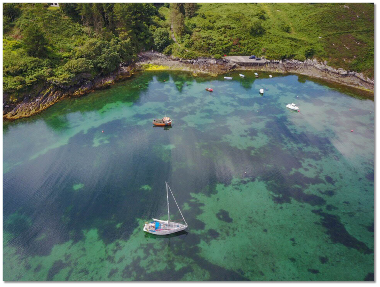
 Bullock Island, Barloge Creek and Lough Hyne
Image: Tom Vaughan
 Use southwestern Ireland’s Coastal Overview for Cork Harbour to Mizen Head for seaward approaches. Barloge Creek and the entrance to Lough Hyne lies 15 miles west of Toe Head and 2½ miles northeastward of Kedge Island. It is tucked into the mainland between precipitous hills to the northwest of Gokane Point. The high, rounded and pine-covered 195 metres high Knockomagh mountain, which stands 1 mile inland to the northeast, provides a good seamark for it.
  Bullock Island and the entrance as seen from the northwest
Image: Michael Harpur
 From the Initial Fix, located 200 metres outside the entrance, steer a course of 295°T until the entrance is visible and pilot in by eye from here.
  The entrance seen from a seaward approach
Image: Burke Corbett
The entrance lies between Carrigathorna, Lalawn Point, on the west side, and the rocks that are situated close south of Bullock Island on the east side.
 The entrance channel between the western shore and the rock cluster close
southwest of Bullock Island
Image: Michael Harpur
The channel is very narrow, 150 metres and decreasing at the entrance, and vessels should favour the western shore on entry to avoid the off-lying rock cluster that is situated close southwest of Bullock Island.

 The inner entrance before the harbour open up
Image: Michael Harpur
The inner entrance between these rocks and the shore on the west is about 100 metres wide with at least a depth of 12 metres.
Once inside maintain a mid-channel course between the island and shore where depths at the narrowest point are 6 metres, then descending to 3 metres as the anchoring area is approached.
 Barloge Creek anchoring area
Image: Michael Harpur
Anchor at the top of the entrance channel east of the small pier that will be seen on the west side of the bay. The area inside shoals quickly once a vessel is past the northwest corner of Bullock Island.  The best place to anchor is off the northwest corner of Bullock Island
Image: Michael Harpur
Try to find a clean piece of sand avoiding fouling seaweed that the bay can be subject to. Land at the small quay on the west side of the bay.
 Tombola connecting Bullock Island to the shore
 Image: eOceanic thanks Oisin Creagh for contributing this image
Don't be tempted to go around the back of the island and into Tranabo Cove. The whole area to the north of the island is very shallow, dries, and it is important to keep to the west of these rocks.
Why visit here?
It is uncertain how Barloge Creek got its name. It forms a small useful bay for small boats down through the centuries and one that provided access to the lough above it on the tide. The name was first recorded in 1750 and it would very much appear to be the conjunction of English words 'bar' and lough' that would aptly describe its use for accessing Lough Hyne. Picturesque Barloge Creek
Image: Michael Harpur
Seeing it as a possible landing point the revenue men set up a pretty, snug, and neat little Coastguard Station on the rising ground over the western shore. Exceeding isolated and seeing little action it became a place where errant coastguards would be sent as a punishment. Around the mid-1800s punishments for coastguards committing misdemeanours, behaviours such as drunkenness, insubordination included dismissal from service, reduction in rank, loss of good conduct badges, fines, reprimands and in some cases, men being transferred, at their own expense, to another less appealing station. Amongst these less desirable locations Barloge numbered. Eventually, the station was removed to the neighbouring bay where it could be more effective.
 Lough Hyne as seen from Knockomagh
Image: georama
It is however Lough Hyne, in Irish Loch Oighinn, situated immediately above Barloge Creek that is the principal attraction of this anchorage. This unique sea-water lake was Ireland’s first Marine Nature Reserve and can be counted amongst West Cork’s most beautiful locations. Lough Hyne is a small rectangular body of water that retains most of its water. It measures only 0.8 by 0.6 km but it is incredibly deep with a maximum depth of 44 metres. High land surrounds the lough, rising sharply above the west shore to a height of 200 metres and a shallow narrow rock-cut channel called The Rapids connects the lough to the sea. Because the channel is subject to strong tides raging up and down it precludes its use as a harbour. So the sheltered lough is secluded from both sea and sheltered by the surrounding hills like a great amphitheatre making it very tranquil.
 Barloge Creek is a stepping stone to beautifull Lough Hyne above
Image: © Bill Cremin
Originally it was thought to be a freshwater lake but this changed after the ice age about 4,000 years ago. Then the sea levels rose and the Atlantic Ocean connected to it through Barloge Creek to flood it with salty ocean water. It is because the Lough's water height sits today around the mid-tide level that there is a rush of water through the narrow Rapids that connects to it through the north end of Barloge Creek and the sea. The channel is 350 metres long and it is only at rest when the half-tide when the external water is level with the lake. Outside of this white waters dominate The Rapids where currents can attain peak speeds of 16 km per hour.
 'The Rapids' the narrow section leading to the lough at low water
Image: Michael Harpur
This twice-daily flush of warm oxygenated seawater sustains a huge variety of marine plants and animals that include as many as 72 species of fish. Many of these are not native to Ireland and more than 50 species are not normally found at this latitude of Europe. A wide variety of environments such as cliffs, salt marsh, beach, and areas of greatly varying water movement add to the area's biodiversity. Scientific investigation began here in 1886 when Rev William Spottswood Green first recorded the presence of the Purple Sea Urchin Paracentrotus Lividus. Further studies commenced in 1923 and today University College Cork (UCC) has three laboratories around the lough.
 Depiction of St Bridgit also known as Bridgit of Ireland
Image: Public Domain
With all these unique attributes it is not surprising that the area would be steeped in human history and folklore. Above The Rapids is a promontory on which stands the ruins of the 8th-Century St. Bridgit's Church. St Bridgit (453-524AD), also known as Bridgit of Ireland, arrived in Ireland a few years after St Patrick (390-461AD), and along with Patrick and Columba, is one of Ireland's patron saints and Ireland's most revered female saint. Moreover, being the saint for animals and crops, she was highly regarded in a very agricultural community. Beside the church is an early inscribed cross plus Saint Bridgit's well, in which the imprints of her knees are thought to be visible in the rocks. During Penal times, when Catholics were barred from practising their religion, isolated secret churches like this were in regular use.
 Castle Island overlooking the entrance
Image: David Brookes
In the middle of the Lough is the distinctive Castle Island that divides Lough Hyne into north and south basins. Still visible on the north-eastern side of the island are the fragmentary ruins of Cloghan Castle, meaning 'stone-built castle', that gives the small bracken covered island its name. This was an O'Driscoll clan castle, dating from the 13th-century, that was built to protect the Lough entrance from a seaward approaching enemy. According to the children's Irish folk tale, King 'Labhra Loinseach', who had asses' ears, once lived in this castle. It was certainly here that that the last of the O'Driscoll clan’s chief, Sir Fineen O'Driscoll, lived out his days. Fineen originally supported the English rulers by confiscating Spanish ships and was so effective that he was knighted for his efforts in 1587. But when West Cork was to see the climax of the Nine Years' War, he changed sides and joined Hugh O'Neill, Hugh Roe O'Donnell and other Irish lords against the English rule of Tudor Queen Elizabeth I. After their devastating defeat at the 1601 Battle of Kinsale, the property of the O’Driscolls was confiscated and given to Lord Castlehaven. Most of the O'Driscoll's fled with the Gaelic Order to the continent as part of the 'Flight of the Earls' but Fineen managed to secure a pardon from Elizabeth I. He retired to the castle in Lough Hyne and eventually died lonely and destitute in 1629. The tower house was probably abandoned after his death and although the island is in the centre of the Marine Reserve, it is not part of the protected area.
 The remains of the O'Driscoll Castle overlooking The Rapids
 Image: Michael Harpur
Most of the stonework seen around the lake today was part of 1846-47 Famine Relief Work projects. The famine devastated this part of Ireland and work on The Rapids, narrowing them and making them more resistant to erosion, along with the seawalls around the lake, were all carried out at this time.
Image: David Brookes
The best view of Lough Hyne may be obtained from Knockomagh's southern side. It contains the wonderful Knockomagh Wood Nature Trail that provides a hiker with one of the most rewarding experiences available of the area. The 2 km trail which takes about 40 minutes, zig-zags up from the north end of the lake to the summit of Knockomagh providing stunning views down into Lough Hyne, the Cork coast and all the way out to the Atlantic Ocean. At the top of the hill, 197 metres above sea level, the panoramic view stretches from Mount Gabriel in the northwest to the islands of Roaringwater Bay, to Sherkin and Cape Clear in the west, and to Galley Head in the east.
 The peaceful abode of Barloge Creek
 Image: Public Domain
From a boating point of view, Barloge Creek is a beautiful secluded location in which to drop anchor for a lunch stop or an overnight stay in good conditions. It offers a beautiful and most unusual anchorage in isolated and highly picturesque scenery. But the star attraction of this haven is the peaceful and serene Lough Hyne. This may all be accessed by foot via the road leading along the western shore from the quay. Or for the more adventurous during an auspicious tidal window when the external waters are on a level at half tide, at other periods of the tide, there is a rapid in the narrow channel.
What facilities are available?
There is nothing in Barloge Creek save for a new landing pier with road access. The slip dries at low tide but the bottom is stony and slopes very gradually. It is located between the market town of Skibbereen and the port of Baltimore. Skibbereen being the larger of the two is approximately 5km from here.Any security concerns?
Never a security issue known to have occurred in Barloge Creek.With thanks to:
Burke Corbett, Gusserane, New Ross, Co. Wexford.Tranabo Cove, Barloge Creek, The Rapids and Lough Hyne overview
About Barloge Creek (Lough Hyne)
It is uncertain how Barloge Creek got its name. It forms a small useful bay for small boats down through the centuries and one that provided access to the lough above it on the tide. The name was first recorded in 1750 and it would very much appear to be the conjunction of English words 'bar' and lough' that would aptly describe its use for accessing Lough Hyne.
Picturesque Barloge CreekImage: Michael Harpur
Seeing it as a possible landing point the revenue men set up a pretty, snug, and neat little Coastguard Station on the rising ground over the western shore. Exceeding isolated and seeing little action it became a place where errant coastguards would be sent as a punishment. Around the mid-1800s punishments for coastguards committing misdemeanours, behaviours such as drunkenness, insubordination included dismissal from service, reduction in rank, loss of good conduct badges, fines, reprimands and in some cases, men being transferred, at their own expense, to another less appealing station. Amongst these less desirable locations Barloge numbered. Eventually, the station was removed to the neighbouring bay where it could be more effective.
Lough Hyne as seen from KnockomaghImage: georama
It is however Lough Hyne, in Irish Loch Oighinn, situated immediately above Barloge Creek that is the principal attraction of this anchorage. This unique sea-water lake was Ireland’s first Marine Nature Reserve and can be counted amongst West Cork’s most beautiful locations. Lough Hyne is a small rectangular body of water that retains most of its water. It measures only 0.8 by 0.6 km but it is incredibly deep with a maximum depth of 44 metres. High land surrounds the lough, rising sharply above the west shore to a height of 200 metres and a shallow narrow rock-cut channel called The Rapids connects the lough to the sea. Because the channel is subject to strong tides raging up and down it precludes its use as a harbour. So the sheltered lough is secluded from both sea and sheltered by the surrounding hills like a great amphitheatre making it very tranquil.
Barloge Creek is a stepping stone to beautifull Lough Hyne aboveImage: © Bill Cremin
Originally it was thought to be a freshwater lake but this changed after the ice age about 4,000 years ago. Then the sea levels rose and the Atlantic Ocean connected to it through Barloge Creek to flood it with salty ocean water. It is because the Lough's water height sits today around the mid-tide level that there is a rush of water through the narrow Rapids that connects to it through the north end of Barloge Creek and the sea. The channel is 350 metres long and it is only at rest when the half-tide when the external water is level with the lake. Outside of this white waters dominate The Rapids where currents can attain peak speeds of 16 km per hour.
'The Rapids' the narrow section leading to the lough at low waterImage: Michael Harpur
This twice-daily flush of warm oxygenated seawater sustains a huge variety of marine plants and animals that include as many as 72 species of fish. Many of these are not native to Ireland and more than 50 species are not normally found at this latitude of Europe. A wide variety of environments such as cliffs, salt marsh, beach, and areas of greatly varying water movement add to the area's biodiversity. Scientific investigation began here in 1886 when Rev William Spottswood Green first recorded the presence of the Purple Sea Urchin Paracentrotus Lividus. Further studies commenced in 1923 and today University College Cork (UCC) has three laboratories around the lough.
Depiction of St Bridgit also known as Bridgit of IrelandImage: Public Domain
With all these unique attributes it is not surprising that the area would be steeped in human history and folklore. Above The Rapids is a promontory on which stands the ruins of the 8th-Century St. Bridgit's Church. St Bridgit (453-524AD), also known as Bridgit of Ireland, arrived in Ireland a few years after St Patrick (390-461AD), and along with Patrick and Columba, is one of Ireland's patron saints and Ireland's most revered female saint. Moreover, being the saint for animals and crops, she was highly regarded in a very agricultural community. Beside the church is an early inscribed cross plus Saint Bridgit's well, in which the imprints of her knees are thought to be visible in the rocks. During Penal times, when Catholics were barred from practising their religion, isolated secret churches like this were in regular use.
Castle Island overlooking the entranceImage: David Brookes
In the middle of the Lough is the distinctive Castle Island that divides Lough Hyne into north and south basins. Still visible on the north-eastern side of the island are the fragmentary ruins of Cloghan Castle, meaning 'stone-built castle', that gives the small bracken covered island its name. This was an O'Driscoll clan castle, dating from the 13th-century, that was built to protect the Lough entrance from a seaward approaching enemy. According to the children's Irish folk tale, King 'Labhra Loinseach', who had asses' ears, once lived in this castle. It was certainly here that that the last of the O'Driscoll clan’s chief, Sir Fineen O'Driscoll, lived out his days. Fineen originally supported the English rulers by confiscating Spanish ships and was so effective that he was knighted for his efforts in 1587. But when West Cork was to see the climax of the Nine Years' War, he changed sides and joined Hugh O'Neill, Hugh Roe O'Donnell and other Irish lords against the English rule of Tudor Queen Elizabeth I. After their devastating defeat at the 1601 Battle of Kinsale, the property of the O’Driscolls was confiscated and given to Lord Castlehaven. Most of the O'Driscoll's fled with the Gaelic Order to the continent as part of the 'Flight of the Earls' but Fineen managed to secure a pardon from Elizabeth I. He retired to the castle in Lough Hyne and eventually died lonely and destitute in 1629. The tower house was probably abandoned after his death and although the island is in the centre of the Marine Reserve, it is not part of the protected area.
The remains of the O'Driscoll Castle overlooking The Rapids Image: Michael Harpur
Most of the stonework seen around the lake today was part of 1846-47 Famine Relief Work projects. The famine devastated this part of Ireland and work on The Rapids, narrowing them and making them more resistant to erosion, along with the seawalls around the lake, were all carried out at this time.
Image: David Brookes
The best view of Lough Hyne may be obtained from Knockomagh's southern side. It contains the wonderful Knockomagh Wood Nature Trail that provides a hiker with one of the most rewarding experiences available of the area. The 2 km trail which takes about 40 minutes, zig-zags up from the north end of the lake to the summit of Knockomagh providing stunning views down into Lough Hyne, the Cork coast and all the way out to the Atlantic Ocean. At the top of the hill, 197 metres above sea level, the panoramic view stretches from Mount Gabriel in the northwest to the islands of Roaringwater Bay, to Sherkin and Cape Clear in the west, and to Galley Head in the east.
The peaceful abode of Barloge Creek Image: Public Domain
From a boating point of view, Barloge Creek is a beautiful secluded location in which to drop anchor for a lunch stop or an overnight stay in good conditions. It offers a beautiful and most unusual anchorage in isolated and highly picturesque scenery. But the star attraction of this haven is the peaceful and serene Lough Hyne. This may all be accessed by foot via the road leading along the western shore from the quay. Or for the more adventurous during an auspicious tidal window when the external waters are on a level at half tide, at other periods of the tide, there is a rapid in the narrow channel.
Other options in this area
Click the 'Next' and 'Previous' buttons to progress through neighbouring havens in a coastal 'clockwise' or 'anti-clockwise' sequence. Alternatively here are the ten nearest havens available in picture view:
Coastal clockwise:
Baltimore - 1.9 miles WSWCastle Ruins - 2.5 miles WSW
Horseshoe Harbour - 2.6 miles WSW
South Harbour (Ineer) - 5.3 miles WSW
North Harbour (Trawkieran) - 5.3 miles WSW
Coastal anti-clockwise:
Castlehaven (Castletownshend) - 3.1 miles ENEBlind Harbour - 3.4 miles ENE
Squince Harbour - 4 miles ENE
Rabbit Island Sound - 4.2 miles ENE
Glandore - 4.6 miles ENE
Navigational pictures
These additional images feature in the 'How to get in' section of our detailed view for Barloge Creek (Lough Hyne).


| Detail view | Off |
| Picture view | On |
Tranabo Cove, Barloge Creek, The Rapids and Lough Hyne overview
Add your review or comment:
Please log in to leave a review of this haven.
Please note eOceanic makes no guarantee of the validity of this information, we have not visited this haven and do not have first-hand experience to qualify the data. Although the contributors are vetted by peer review as practised authorities, they are in no way, whatsoever, responsible for the accuracy of their contributions. It is essential that you thoroughly check the accuracy and suitability for your vessel of any waypoints offered in any context plus the precision of your GPS. Any data provided on this page is entirely used at your own risk and you must read our legal page if you view data on this site. Free to use sea charts courtesy of Navionics.