
.jpg)
Nested up a river and a dozen miles from the sea Wareham offers complete protection. Attentive navigation is required for access and it is shallow, making it more suited to moderate to shallow draft vessels that are prepared to work the tides.

Keyfacts for Wareham
Facilities


Nature


Considerations


Protected sectors

Approaches

Shelter

Last modified
July 18th 2018 Summary
A completely protected location with attentive navigation required for access.Facilities
Nature
Considerations
Position and approaches

Expand to new tab or fullscreen
Haven position
 50° 41.038' N, 002° 6.554' W
This is the position of Wareham Quay


What are the key points of the approach?
Offshore details are available in the westbound  or eastbound sequenced 'Selsey Bill to Start Point' coastal description. Entry into Poole Harbour and the run up to Poole are covered in the Poole Town Quay
  entry.
or eastbound sequenced 'Selsey Bill to Start Point' coastal description. Entry into Poole Harbour and the run up to Poole are covered in the Poole Town Quay entry.- Once sufficient water is assured follow the well-marked channels all the way up to Wareham.
Not what you need?
Click the 'Next' and 'Previous' buttons to progress through neighbouring havens in a coastal 'clockwise' or 'anti-clockwise' sequence. Below are the ten nearest havens to Wareham for your convenience.
Ten nearest havens by straight line charted distance and bearing:
- Redclyffe Yacht Club - 0.4 nautical miles ESE
- Ridge Wharf Yacht Centre - 0.8 nautical miles E
- Shipstal Point - 3.3 nautical miles E
- Lake Yard Marina - 3.8 nautical miles ENE
- Poole Yacht Club - 4.5 nautical miles ENE
- Brownsea Island - 4.6 nautical miles E
- Cobb's Quay - 4.7 nautical miles ENE
- Goathorn Point - 4.8 nautical miles E
- Port of Poole Marina - 4.9 nautical miles ENE
- Poole Town Quay - 4.9 nautical miles ENE
These havens are ordered by straight line charted distance and bearing, and can be reordered by compass direction or coastal sequence:
- Redclyffe Yacht Club - 0.4 miles ESE
- Ridge Wharf Yacht Centre - 0.8 miles E
- Shipstal Point - 3.3 miles E
- Lake Yard Marina - 3.8 miles ENE
- Poole Yacht Club - 4.5 miles ENE
- Brownsea Island - 4.6 miles E
- Cobb's Quay - 4.7 miles ENE
- Goathorn Point - 4.8 miles E
- Port of Poole Marina - 4.9 miles ENE
- Poole Town Quay - 4.9 miles ENE

Chart

How to get in?

Wareham is a charming and picturesque historic market town that lies five miles west of Poole Harbour. It is located on a peninsula formed by the Rivers Trent and Frome which run eastwards parallel to each other to drain into Poole Harbour about a mile below the town. The town is accessed via the Wareham Channel which is a continuation of Poole’s main channel that leads in from the entrance. The Wareham Channel then continues to the mouth of the River Frome from which the river then meanders its way up to Wareham. It is a journey of about 7 miles from Poole Quay through to Wareham Quay.
Wareham Quay has as little as 0.2 metres at MLWS but it tends not to fall below 0.7 metres except when there is a very low river flow. Approaches through Poole Bay and Poole Harbour provide drafts of not less than 6 metres CD up to the Wareham Channel. The run up to the town quay has a least depth of 0.1 metres CD, typically providing over 1.0 metres of water at MLWN, but it is liable to silting. The tide range is little more than 1 metre.
Wareham Quay is more the domain of the moderate draft craft who are prepared to make an approach at high water ± 1 hour. The absolute maximum draft that it could support is 1.5 metres but a conservative 1.2 metres draft vessel would be more advisable. There is a speed limit of 4kn in river.
It is possible to anchor on the port side of the river anywhere above Ridge Wharf Yacht Centre and clear of the River Frome salmon holes - locations where anchoring is prohibited which are best seen on the chart. In practice however a chain of moored craft leave little or no space to anchor without blocking the fairways' busy river traffic.
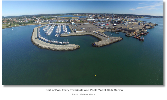
 Entry into Poole Harbour and the run up to Poole are covered in the Poole Town Quay entry. Continue past the Port of Pool Ferry Terminals and Poole Yacht Club Marina, to proceed between the Hutchins WH1 Fl.G.3s green starboard WH2 Fl.R.2s port buoys.
A mile westward of the Port of Pool Ferry Terminals the pretty Arne Peninsula will be seen. The peninsula is about 1½ miles wide, comprising woods, fields and heathland the vast majority of which is a nature reserve. It projects nearly three miles into the harbour from the southern shore. This reduces the tideway between its northernmost Gold Point and the Hamworthy shoreline to less than ½ a mile.

The WH3 Fl.G.5s green starboard and WH4 Fl.R.4s port buoys are then passed in this tideway close to the north shore. 300 metres to the northwest of these buoys, and opposite Gold Point, stands Moriconium Quay on the north shore. It is made conspicuous by its high-rise buildings. Lake Yard Marina
, that accommodates visitors on its numerous moorings, is the second marina, immediately behind and attached to the private Moriconium Quay.
A number of big-ship mooring buoys will be seen ¼ of a mile above. These should be left to port, with the WH5 Fl.G.3s green starboard buoy laying to the north of these, passed on its correct side. The channel then turns south westward to flow close to the northwest shore of Arne Peninsula passing Russell Quay.

From Russell Quay the channel then runs almost straight for 1½ miles along the long Wareham Reach where the Arne Peninsula heathland and the views over the Purbeck Hills may be enjoyed. It is marked by a number of lit starboard and port buoys. A pair of lit red and green posts with topmarks mark the Poole Harbour Limit northward of the marshy Gigger's Island.
After these posts the channel turns south and swings around north westward again passing Bower Point and Turner's Cove. It then swings south westward to the south of Swineham Point where the river, between walls of reeds, properly opens up. Keep to the middle south of Swineham Point after which the outside of the bends provides the best depths as the River Frome meanders 1¾ miles up to Wareham.

The river's pathway is marked all the way by an abundance of unlit beacons on each side. With the river being so narrow, and the 4 knot speed limit seeming optimistic, it will take nearly an hour from here but it will be enjoyable.

Ridge Wharf Yacht Centre
, that accommodates visiting boats, will be passed on the southern shore ¾ of a mile upriver from Swineham Point. 
The rivers primary danger will be encountered ½ a mile upstream at the Redcliff bend just before the Frome turns through 90° to pass the pontoons of Redcliff Yacht Club. Those operating on the margins should exercise extreme caution approaching the Redcliff bend just after the slip on the eastern shore. An underwater steel pipe, that rises on the river’s eastern side to a drying height of 0.3 metres, has been struck by many unsuspecting visitors applying the conventional wisdom of keeping to the outside of the bends for best water. Expect to find a mean tide depth of 1.22 metres over the shallowest part of the pipe an hour before high water.

The best approach is to make an exception to the age old river rule here by passing the thickly forested red cliff, well over on the west side of river, or on the inside of the approach to the right-hand bend.

Redclyffe Yacht Club
, that accommodate visitors where they can, will then be passed beyond the bend. From the club Wareham is only a ½ a mile upstream and will be clearly visible above the swaying reeds that flank the river. A drying berth can usually be found alongside. Do not use the well-marked Ferry Quay as tourist launches continually use it.
The Priory Hotel Wareham allows patrons to come alongside its pontoon. It would be advisable to check their prices are within the cruising budget.
Boats that can pass under South Bridge will find the tidal river's upper limit being approximately ½ mile beyond the Town Quay.
Why visit here?
First recorded as Werham, in the Anglo-Saxon Chronicle entry of 784, and then Warham, in Doomsday in 1086, the town is thought to have got its name from the combination of ‘weir’ with hām, or hamm, the old English for ‘homestead’.
Whichever the case Wareham’s strategic position between the rivers Trent, historically called the Piddle, and Frome would always have made it an attractive site. It provided convenient access from the sea to the Purbecks and held a naturally defensive position being on a ford between two rivers. Excavations at the nearby Bestwall site have produced evidence that there was a Mesolithic settlement here that dates as far back as 9000 BCE. The first house discovered here dates to the middle of the 1500 BCE and there is archaeological evidence that a small Roman settlement underlies the current town. Roman Wareham appeared to have consisted of two distinct sites, one in the area of the north-west corner of the later town, and the other in the area of Lady St Mary’s church.
The modern settlement we see today was founded by the Saxons who conquered east Dorset in the middle of the 7th Century. The town was set to become one of the most important towns in the county for the Saxons. It started as a priory that was founded in 672, and in 701 the first bishop of Sherborne, St. Ealdhelm, built St. Martins Church which was subsequently rebuilt in the early 11th century, and founded a nunnery here. In time a village grew around the ecclesiastical community and developed to be a place of some importance in the seventh, eighth and ninth centuries by which time it had become home to the royal house of Wessex. By then it had established itself as a river port with strong links to both the English Channel via Poole Harbour, and settlements further inland by means of both the River Piddle and River Frome. A mark of the town’s importance was that it was chosen to be a Saxon royal burial place. Most notably that of King Beorhtric who was probably buried at the 8th century Minster church in 802, where Lady St Mary’s church stands today. But the town’s capabilities and prosperity was soon to attract attacks by the Vikings.

Once the town fell back into the hands of the Saxons, Alfred made Wareham one of his primary ‘burhs’. This was part of his military and administrative programme set to fortify the lands against further Danish incursions after his final victory over Guthrum. Between 880 and 885 the town was surrounded on three sides by an earth bank, the fourth side of the town was defended by the River Frome, with a wooden stockade on top. Wareham’s ‘burh’ was one of 33 in a network, mainly in Wessex, that were formed so that no place was more than 20 miles, or a day’s march where the men would gather to fight in the event of an attack. But this did not stop the Danes attacking again in the following decades. In 998 they entered Poole Harbour, stationed their fleet at the mouth of the Frome, from where they penetrated Dorset.

Not long afterward, in 1015, King Canute came into Poole with a fleet of 200 ships to execute his very successful conquest of England. The Anglo-Saxon Chronicle noted ‘[Cnut] came into Sandwich, and straightway sailed around Kent to Wessex until he came to the mouth of the Frome, and harried in Dorset and Wiltshire and Somerset’. He destroyed the town and then made Wareham his naval station for the process of occupying southern England. Canute went on to secure half the country by defeating Edmund Ironside at Ashingdon in Essex. He later then took all of the country when Edmund conveniently died in November 1016. In the reign of Canute, Wareham was the shire town and a thriving seaport, with a house for the king which he occupied during his hunting expeditions.

Worse was to come the following year when much of Wareham’s population died of the plague. During 1418 the Alms-houses were founded on East Street to care for the poor and needy. By 1461 Wareham Castle had fallen into serious disrepair and in 1540 Wareham town was described as being in a terrible condition. In 1644, during the Civil War, it was the site of a fierce battle where as much as 2,000 Cromwellian soldiers besieged and stormed the town. It was to change hands several times between the Royalists and Parliamentarians and it closely escaped the severe destruction of Corfe Castle when Parliament decided the ‘walls’ of Wareham were not to be breached.

Though saved from destruction during the civil war the town was largely destroyed a century later by the accidental ‘Great Fire of Wareham’. This occurred in 1762 when ashes were carelessly thrown out onto a rubbish tip at the back of ‘The Bulls Head’ Inn, where Lloyds Bank now stands on South Street. More than 140 medieval thatched buildings, two-thirds of the town, were razed to the ground in the following three hours. The town was rebuilt, in the Georgian style of the day, and it began to enjoy a period of prosperity. Local merchants secured lucrative contracts with the Royal Navy in Portsmouth to supply fruit and vegetables and other commodities. Lime and cement, and large quantities of potters' pipe and other kinds of clay industries then took off in and around Poole Harbour area. Wareham’s clays were much sought after and sent as far as Staffordshire to be used by Joshia Wedgwood in many of his products. This local trade continued to be handled at the Quay until the construction of the railway in the 19th century.

Today Wareham’s main streets appear in its reborn Georgian style but is still substantially contained within its square historic street pattern. Some thatched buildings survived the fire and remain to be seen to the present day. Nothing however remains of its Norman castle and the site of the former keep is now occupied by a 19th century building.

Wareham Town Museum now tells the story of the town’s two millennia of history, that is still in evidence today thanks to its Saxon earthen ramparts. These defensive structures remain one of Wareham’s most visually striking features and may be explored via its walls' walks. Wareham’s ancient history also means that it has a considerable number of historic buildings most notably its ancient churches. The church of St. Mary contains a chapel dedicated to St Edward, commemorating that Edward who was murdered at Corfe Castle and whose body lay there before its removal to Shaftesbury. It also possesses a remarkable Norman font of lead and boasts a 14th Century chancel and a Tudor tower with a ring of 10 bells.

Founded by St Aldhelm in the 7th Century St Martin's Church is the most complete example of an Anglo-Saxon church in Dorset. The present church dates from about AD 1030 having being rebuilt after Canute's raid. It has a series of wall paintings, the earliest of which was painted in the 12th century. In the north aisle sits a stone effigy of T. E. Lawrence better known as 'Lawrence of Arabia'. Lawrence spent the last years of his life in the Wareham area, living at ‘Clouds Hill’ cottage, Moreton, near Bovington Camp where he served as a private soldier.

From a boating perspective pretty Wareham, surrounded by its grasslands and the rolling hills of Purbeck, is an inland joy for the shoal draft boater. The town’s history is all ready to be explored within a short stroll, there are a host of delicious eateries and plenty of interesting and unique shops to browse through. The quay itself is a lively meeting place with ample pubs and restaurants. The town hosts events in July with a parade, fireworks and music by the Quay, along with a separate summer music festival, with bands playing on the Quay, the Town Hall and the town's pubs.
What facilities are available?
Wareham has all the services that you would expect from a town of this size. There are a choice of chemists, two supermarkets, a post office, several banks and a host of bars and restaurants. The town also has a large range of independent shops and retailers. In Wareham you can still buy fresh meat at traditional butchers, superb cakes and freshly baked bread from local bakers and source local cheese, fish and other produce.Wareham retains its market town tradition by having a Farmers Market in the Town Hall on the 2nd and 4th Thursday of the month and a Home Producers market every Thursday in the United Reformed Church Hall in Church Street. A very popular Saturday Street Market is held on the quay each week.
There are nine local bus services from Wareham to various destinations from Swanage to Poole to Waterloo. The town is on the South Western Main Line between London Waterloo and Weymouth.
With thanks to:
John Binder CMM Poole Quay Boat Haven & Port of Poole Marina manager. Photography with thanks to K&S Cross, Jim Linwood and Michael Harpur..JPG)
.JPG)
.JPG)
.JPG)
.JPG)
.JPG)
.JPG)
.JPG)
.JPG)
.JPG)
Wareham Overview


Add your review or comment:
Please log in to leave a review of this haven.
Please note eOceanic makes no guarantee of the validity of this information, we have not visited this haven and do not have first-hand experience to qualify the data. Although the contributors are vetted by peer review as practised authorities, they are in no way, whatsoever, responsible for the accuracy of their contributions. It is essential that you thoroughly check the accuracy and suitability for your vessel of any waypoints offered in any context plus the precision of your GPS. Any data provided on this page is entirely used at your own risk and you must read our legal page if you view data on this site. Free to use sea charts courtesy of Navionics.