
_county_wexford_ireland_DSC_0xx (71).jpg)
A good harbour in most conditions, it is entirely exposed to the northeast right around to the northwest. However, port activities and the busy ferry traffic make this an uneasy berth. Access is straightforward, night or day and at any stage of the tide, through its well-marked commercial channels.


Keyfacts for Rosslare Europort (Rosslare Harbour)
Facilities


Nature


Considerations
Protected sectors

Approaches

Shelter

Last modified
June 12th 2020 Summary
A tolerable location with straightforward access.Facilities
Nature
Considerations
HM  +353 53 91 33249
  Ch.12 [Rosslare Harbour]
+353 53 91 33249 Ch.12 [Rosslare Harbour] Position and approaches

Expand to new tab or fullscreen
Haven position
 52° 15.204' N, 006° 20.388' W
This is the Fisherman's Quay where visiting boats are usually accommodated.
What is the initial fix?
The following Rosslare Europort initial fix will set up a final approach:
 52° 14.787' N, 006° 15.696' W


What are the key points of the approach?
Offshore details are southbound vessels are available in eastern Ireland’s coastal overview for Dublin Bay to Rosslare Harbour  . Details for vessels approaching from the southwest are available in southwestern Ireland’s coastal overview for Rosslare Harbour to Cork Harbour .
. Details for vessels approaching from the southwest are available in southwestern Ireland’s coastal overview for Rosslare Harbour to Cork Harbour .Not what you need?
Click the 'Next' and 'Previous' buttons to progress through neighbouring havens in a coastal 'clockwise' or 'anti-clockwise' sequence. Below are the ten nearest havens to Rosslare Europort (Rosslare Harbour) for your convenience.
Ten nearest havens by straight line charted distance and bearing:
- Rosslare Bay (or South Bay) - 0.4 nautical miles W
- Ballytrent - 2.3 nautical miles S
- Carne - 3.2 nautical miles S
- Wexford Harbour - 6.7 nautical miles NW
- Kilmore Quay - 10.4 nautical miles WSW
- Little Saltee (landing beach) - 11.3 nautical miles SW
- Little Saltee (east side) - 11.3 nautical miles SW
- Little Saltee (west side) - 11.7 nautical miles SW
- Great Saltee (landing beach) - 12.8 nautical miles SW
- Gilert Bay - 13 nautical miles SW
These havens are ordered by straight line charted distance and bearing, and can be reordered by compass direction or coastal sequence:
- Rosslare Bay (or South Bay) - 0.4 miles W
- Ballytrent - 2.3 miles S
- Carne - 3.2 miles S
- Wexford Harbour - 6.7 miles NW
- Kilmore Quay - 10.4 miles WSW
- Little Saltee (landing beach) - 11.3 miles SW
- Little Saltee (east side) - 11.3 miles SW
- Little Saltee (west side) - 11.7 miles SW
- Great Saltee (landing beach) - 12.8 miles SW
- Gilert Bay - 13 miles SW

Chart

What's the story here?
 Rosslare Europort
Image: Michael Harpur
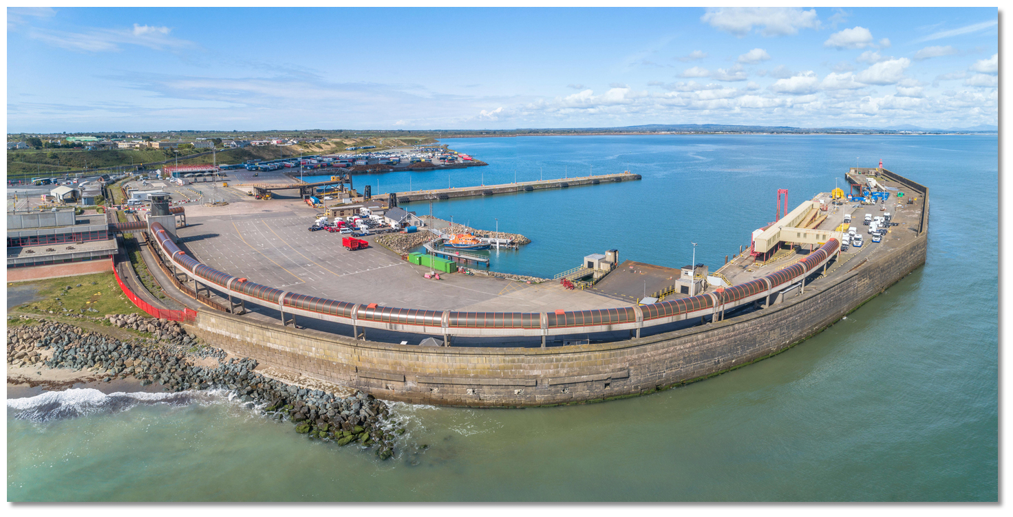
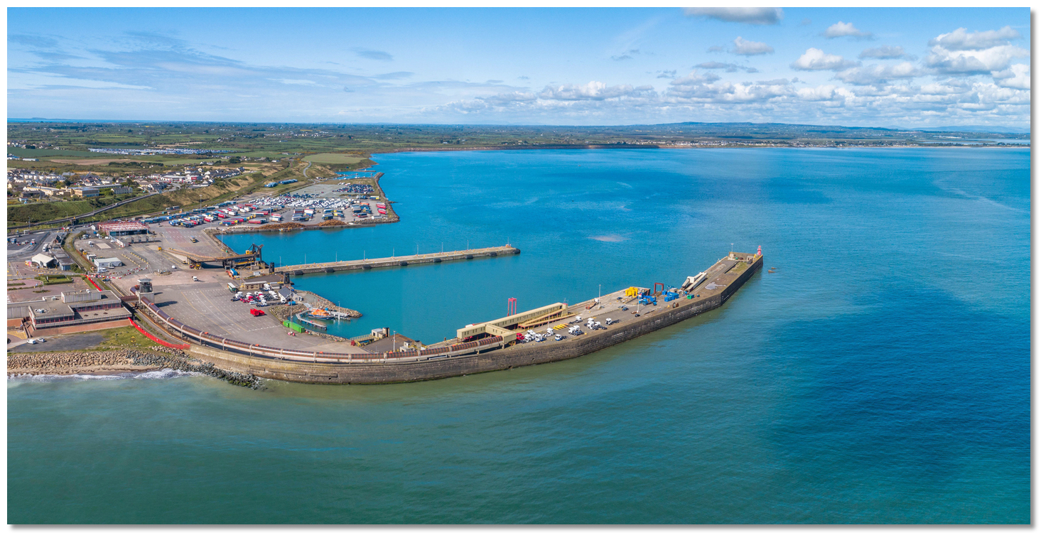
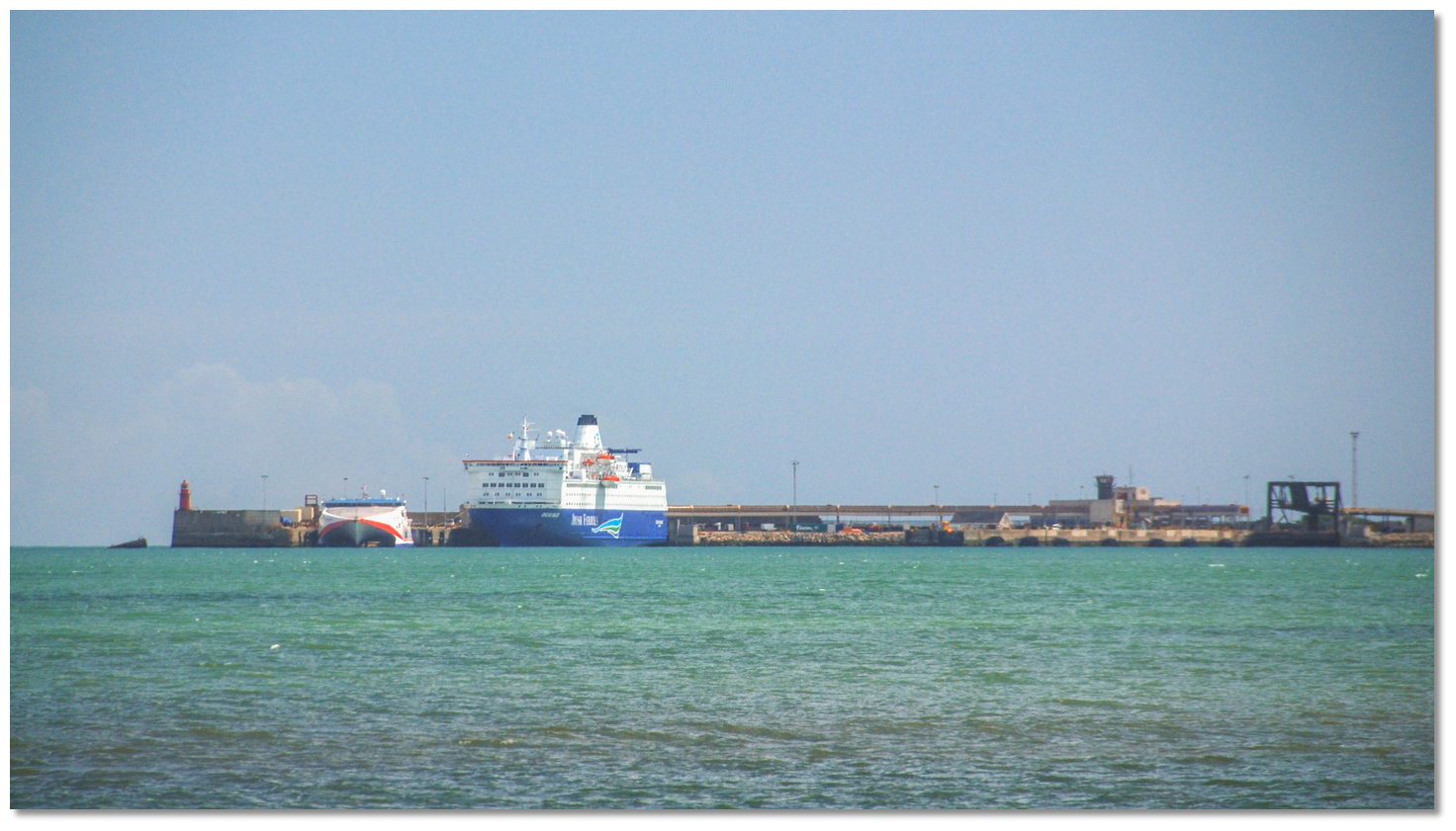
Rosslare Europort, formerly and more commonly known as Rosslare Harbour, is situated on the southeast corner of County Wexford about six miles north of Carnsore Point on the south shore of Rosslare Bay. It is an artificial harbour with four ship berths and a northwest-facing entrance that is protected from the east by a substantial breakwater with a pierhead light standing on its seaward end. It is the second most strategically important seaport in the State after Dublin and the Irish terminus for UK vehicle and passenger ferries from Fishguard and Pembroke, plus the continental ferries from Le Havre, Cherbourg and Roscoff. It is also the second-busiest port in terms of ship visits and gross tonnage and handles more unitised freight than any other Irish seaport except Dublin.
 Ferry approaching Rosslare Europort
Image: Michael Foley via CC BY-NC 2.0
This makes it a very busy port with constant and sometimes fast-moving commercial ship movements. The focus is singularly on commercial shipping and it has no specific facilities for leisure craft. Being a major port it is also subject to the 'International Ship and Port Facility Code' which may restrict or prohibit access to the harbour area.
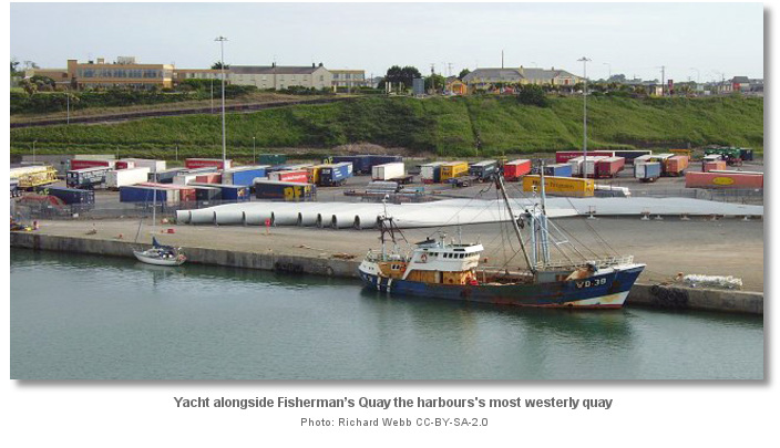
_side_of_the_harbour.jpg) Fisherman’s Quay on the harbours southwest (leftmost) side of the harbour
Fisherman’s Quay on the harbours southwest (leftmost) side of the harbourImage: Michael Harpur
That said, the Harbour Master will wherever possible try to accommodate a yacht on Fisherman’s Quay on the harbours southwest side. The least depth in the harbour area as a whole is 5 metres. It is essential that Rosslare Harbour is contacted well in advance on Ch.12 [Rosslare Harbour],
+353 (0) 53 91 33249, to make berthing arrangements. It is also worth considering that a more convenient berth with the jetty to land is to anchor just outside the Small Boat Harbour a ⅓ of a mile westward of Rosslare Europort, see Rosslare Bay  .
. Boats alongside Fisherman’s Quay
Image: Michael Harpur
It should also be remembered that the harbour is entirely open to the northeast right around to the northwest although big seaways are somewhat broken by the off-lying banks. However, the downwind havens of Carne
, just 2.1 miles almost directly southward, provides a well-protected anchorage during strong northwesterly winds and Kilmore Quay , 6½ miles west by southwest, albeit via a longer dogleg passage around Carnsore Point, provides shelter from the northeast.How to get in?
 Rosslare Europort situated on the south shore of Rosslare Bay
Image: Michael Harpur
 Ireland’s coastal overviews for Dublin Bay to Rosslare Harbour and Rosslare Harbour to Cork Harbour converge here. Use as appropriate for seaward approaches.
 The extensive shoal that contains Holden’s Bed and the Long Bank prevent vessels approaching the harbour directly from the Irish Sea. It is instead entered around these shoals by the South Shear Channel or North Shear Channel. The principal approach is via the South Shear Channel that passes south of the Holden’s Bed and the Long Bank. The North Shear Channel passes north of these and then to the west, between the banks and the mainland.
 Rosslare Europort from the approach channel
Image: Michael Harpur
 From the initial fix, close to 'The South Long' buoy that marks the entrance into the South Shear Channel, the main shipping channel buoys and sectored leading light may be followed into the port. Simply steering a course for the light structure on the head of Rosslare Harbour’s breakwater, with a directional light Oc WRG.5s15m13/10M, on 283° T, will leading through North Shear Channel into the harbour. The North Shear Channel has plenty of water all the way with depths in excess of 11 metres to within 1.8 miles of the breakwater.
By night the pierhead's directional light, Oc. WRG.5s15m13/10M, and its white sector 283°-286° leads through the entrance of the channel. The channel has a controlling depth of 6.7 metres at the entrance decreasing to 3.9 to 4.5 metres off the head of the breakwater.
The channel is used by large commercial traffic and it is essential that a watch is maintained for large commercial shipping in the South Shear Channel. Do not under any circumstance impede shipping movements as vessels will be restrained by draft in the channels and have limited capability to alter course. It is recommended that Rosslare Harbour is contacted on channel 12 so they are aware and can provide advice on the planned channel transit. Throughout the approach, a continuous listening watch should be maintained on VHF channel 12.
Image: Michael Harpur
Due to the frequency of ship movements in the channel, it is courteous to stay outside of the marked channel and run close parallel to it to avoid the commercial operations. The south side of the channel has more rocks and stronger currents; most notably the Carrack Rocks extending from Greenore Point to the southeast of the harbour. It is essential to entirely avoid the entire area from Greenore Point out to the Splaugh red port buoy, Fl.R.6s, as it is foul and subject to very strong currents that could lead to difficulties. The north side, by contrast, has no obstructions, lighter currents and has plenty of deep water. This is the best approach for leisure craft to take.
 Rosslare Europort's pierhead light and water tower make for prominent marks
Image: Michael Harpur
On the approach, Rosslare Bay’s broad arc of shoreline will be seen to be moderately high clay cliffs out to about two miles northwest of Rosslare Europort. It then gradually descends down to a strip of low sandhills that make up the east side of Wexford Harbour. The harbours substantial breakwater with its 5-metre high red steel tower standing on its seaward end will be conspicuous. On the cliff above the harbour, a large flat-roofed hotel building will be seen plus a water tower standing about half a mile southeast of the harbour.
Having approached Rosslare Europort either through South Shear or through North Shear (as covered in the Dublin Bay to Rosslare Harbour
coastal description, the head of the breakwater should be rounded at a good distance. The tides around Rosslare Harbour can be very strong and are at their strongest at LWS where they may attain speeds of 4 knots. 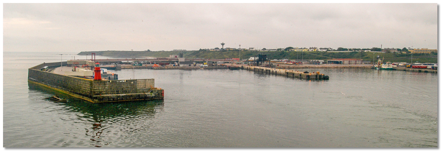 Rounding the pierhead
Image: Michael Harpur
Once around the pierhead continue past the middle New Ferry Pier to Fisherman’s Quay, the inner or westernmost quay, where leisure craft are typically accommodated and where the least depth in the harbour area is 5 metres. _side_of_the_port__.jpg) Fisherman's Quay located on the southwest (left) side of the port
Fisherman's Quay located on the southwest (left) side of the port Image: Michael Harpur
Berth as directed by the Harbour Master and be prepared to move at short notice to accommodate commercial shipping. There are no anchor berths within the harbour area and no anchoring is permitted on the line of Rosslare Harbour breakwater out to a distance of half a mile to the northwest as it interferes with commercial traffic.
Why visit here?
Rosslare derives its name from Irish Ros Láir meaning "the middle peninsula". Although the harbour itself is located close to the previously existing settlement of Ballygeary, it was named after the village of Rosslare, some 3 nm along the coast. Now Rosslare Europort, in Irish Calafort Ros Láir, it is a modern seaport and the surrounding town grew up to serve the needs of the harbour.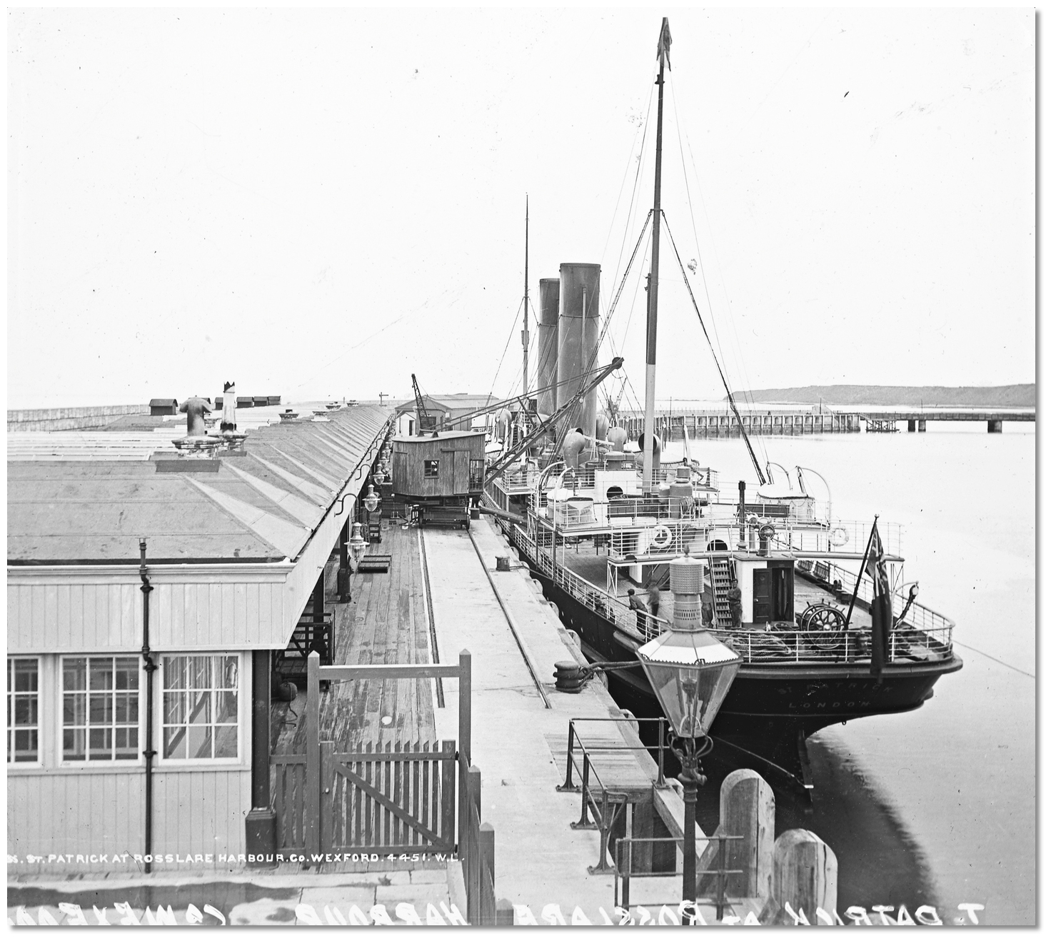 Rosslare Harbour circa 1910
Image: Public Domain
The first port was constructed in 1882, in what was formerly called Rosslare Harbour, and further extended in 1902 by the Great Western Railway and the Great Southern and Western Railway to accommodate steam ferry traffic between Great Britain and Ireland. Rosslare Harbour railway station opened on 30 August 1906. The harbour was further remodelled in 1962 to cater for motor car traffic. Prior to this the method of unloading was the archaic cargo lifting approach of the time. Transported cars were lifted off by a crane onto a flat truck where it was then taken off on a ramp at Ballygeary. Development work continued to the late 1990s when the northwest part of the port was constructed largely on reclaimed land. This extension and modernisation of facilities is an ongoing process to encourage the increase in cars and trucks carried on the ferries where, despite a drop in foot passengers, the port has been highly successful.
 Rosslare Europort today
Image: Michael Harpur
Today the busy RoRo cargo port is the second most strategically important seaport in the State after Dublin. Its passenger throughput is approaching a million annually and it is the second-busiest port in terms of ship visits and gross tonnage, and it also handles more unitised freight than any other Irish seaport except Dublin. Passenger ferries operate to and from Fishguard (via Stena Line) and Pembroke Dock (via Irish Ferries) in Wales, and to Cherbourg, Roscoff and St. Nazaire in France.
 Rosslare Europort is the second most, after Port of Dublin, port of Ireland
Image: Michael Harpur
Through all this development the harbour has retained its rail heritage. The port to this day is still operated by Iarnród Éireann, Ireland's national railway operator. Iarnród Éireann operates a train service from the heart of the port, located a few minute’s walk from the pier and Terminal Building, that travels north through all the stations along the east coast to Dublin Connolly railway station.
From a boating point of view, the port is accommodating but is in no way equipped to receive leisure vessels. Moreover, the level of port activity makes it anything but a restful leisure vessel destination. It does make for an ideal location to drop in to await a tide or change of wind whilst on transit and is a good sanctuary in a southwest gale with port and small-town facilities easily at hand. Likewise, the excellent supermarket at the top of the hill, plus the pubs and restaurants make it a very good provisioning point or stop-by location.
Rosslare is also a designated a port of entry that may be used for clearing in purposed by vessels arriving entering territorial waters of the Republic of Ireland from outside of the EU & UK territories. The excellent national and international transport connections make it an ideal point to collect or set down crew.
What facilities are available?
Rosslare Harbour is a small town with all normal facilities, supermarket, bank, post office and petrol station, which are all within fifteen minutes walk from the Fisherman’s Quay, albeit up a hill. You can catch a train from the Harbour direct to Dublin, or Ferries to UK or France and there are car hire and additional services available in the port area.The port is an ISPS (International Ship Port Facility Code) compliant and this may require arrangement with the port authority.
Any security concerns?
The port is an ISPS (International Ship Port Facility Code) compliant and the area where the vessel will be alongside will be closed off to the public.With thanks to:
Phil Murphy, Kilmore Quay Harbour Master.
_county_wexford_ireland_DSC_0xx (77).JPG)


Add your review or comment:
Please log in to leave a review of this haven.
Please note eOceanic makes no guarantee of the validity of this information, we have not visited this haven and do not have first-hand experience to qualify the data. Although the contributors are vetted by peer review as practised authorities, they are in no way, whatsoever, responsible for the accuracy of their contributions. It is essential that you thoroughly check the accuracy and suitability for your vessel of any waypoints offered in any context plus the precision of your GPS. Any data provided on this page is entirely used at your own risk and you must read our legal page if you view data on this site. Free to use sea charts courtesy of Navionics.