
_england_NIC_9293_stitch.jpg)
Tucked into the corner of the naturally protected bay and behind large harbour walls, the harbour offers complete protection from all conditions, if subject to some swell in heavy south easterlies. Safe access is available in all reasonable conditions, day or night and at all stages of the tide. However, there can be a backwash from the harbour wall that makes the entrance hazardous in highly developed southeasterly conditions. Brixham Harbour would be the preferred option during these times.

Keyfacts for Torquay
Facilities


 pump out facilities")


Nature


Considerations


Protected sectors

Approaches

Shelter
Last modified
January 28th 2019 Summary
A completely protected location with safe access.Facilities
Nature
Considerations
HM  +44 1803 292429 Marina +44 1803 200210
  torquay.harbour@torbay.gov.uk
  tor-bay-harbour.co.uk/
  Ch.14 [Torquay Harbour] 80 [Torquay Marina]
+44 1803 292429 Marina +44 1803 200210 torquay.harbour@torbay.gov.uk tor-bay-harbour.co.uk/ Ch.14 [Torquay Harbour] 80 [Torquay Marina] Position and approaches

Expand to new tab or fullscreen
Haven position
 50° 27.436' N, 003° 31.728' W
This is the head of Haldon Pier, at the entrance which exhibits a light, Q.G.9m6M.
What is the initial fix?
The following will set up a final approach:
 50° 27.392' N, 003° 31.850' W


What are the key points of the approach?
Offshore details are available in southwestern England’s coastal overview from Portland Bill to Start Point  .
.
. - Tor Bay is entered between Hope’s Nose and Berry Head situated 4 miles to the south.
- The expansive sheltered bay is very straightforward. As, apart from some rocks that all lie within a ½ mile off the bay's north end, it is entirely clean beyond the 5-metre contour.
- Outside of these, the bay offers plain sailing right up to the lit starboard marker outside the entrance to the harbour.
Not what you need?
Click the 'Next' and 'Previous' buttons to progress through neighbouring havens in a coastal 'clockwise' or 'anti-clockwise' sequence. Below are the ten nearest havens to Torquay for your convenience.
Ten nearest havens by straight line charted distance and bearing:
- Anstey’s Cove - 1.6 nautical miles NE
- Hope Cove (Tor Bay) - 1.6 nautical miles ENE
- Babbacombe Bay - 1.6 nautical miles NNE
- Paignton - 1.8 nautical miles SW
- Watcombe Cove - 2.4 nautical miles NNE
- Brixham - 3.2 nautical miles SSE
- Teignmouth - 5.1 nautical miles NNE
- Dittisham & The River Dart - 5.2 nautical miles SSW
- Dartmouth Harbour - 7 nautical miles S
- The Bight - 10 nautical miles NNE
These havens are ordered by straight line charted distance and bearing, and can be reordered by compass direction or coastal sequence:
- Anstey’s Cove - 1.6 miles NE
- Hope Cove (Tor Bay) - 1.6 miles ENE
- Babbacombe Bay - 1.6 miles NNE
- Paignton - 1.8 miles SW
- Watcombe Cove - 2.4 miles NNE
- Brixham - 3.2 miles SSE
- Teignmouth - 5.1 miles NNE
- Dittisham & The River Dart - 5.2 miles SSW
- Dartmouth Harbour - 7 miles S
- The Bight - 10 miles NNE

Chart

What's the story here?
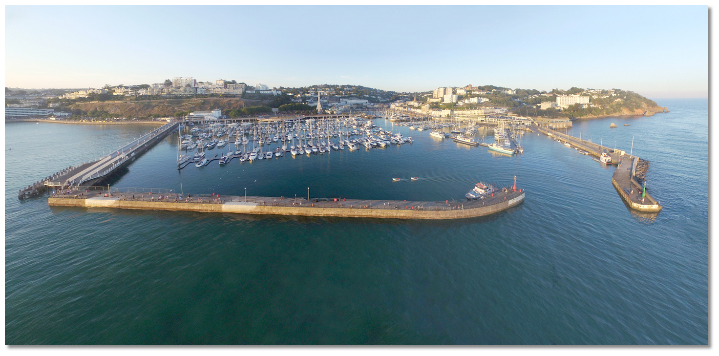
 Torquay Harbour
Image: Michael Harpur
Situated in the northwest corner of Tor Bay, Torquay is an extensive seaside resort town and the region's main city. The town is fronted by a large commercial harbour that is to the largest part focused on leisure craft. It consists of an outer basin enclosed by the arms of two extensive piers, Haldon Pier extending westward and Princess Pier extending south and then southeast from the northwest shore. The entrance between the two offset pierheads is west facing and 50 metres wide. Within the outer harbour is an inner basin that is entered between tidal gates.
The harbour receives visiting boats in the outer harbour at either the council-run pontoon or the extensive Torquay Marina that is operated by MDL.
Torquay, Paignton and Brixham Harbours are municipal harbours under Torbay Borough Council. In Torquay the Council provides a 96-metre long council-run pontoon on the inside of Haldon Pier, to starboard, accessed by a gangway from above. It also has another pontoon on the port side in the ‘V’ section of Town Dock.
The council berths are not bookable in advance and are only available on a first come basis. During busy periods smaller or similar sized vessels may be directed to raft alongside vessels moored to pontoons. It is possible to call
Ch. 14 [Torquay Harbour] for advice on availability but it is rare that anyone gets turned away. Alternatively +44 1803 292429, torquay.harbour@torbay.gov.uk.  Municipal pontoons directly inside the entrance
Image: Michael Harpur
All vessels intending upon using these pontoons should call the harbourmaster on VHF Ch. 14 on approach. Large vessels should contact the harbour prior to entering the harbour.
Pontoon charges (2018) including VAT.
- • Up to 4 metres £10 per day, £48 per week.
- • Over 4 metres up to 5.5 metres £11 per day, £53 per week.
- • Over 5.5 metres up to 7 metres £12 per day, £58 per week.
- • Over 7 metres £1.94 per metre per day.
Pontoon moorings are free for the first two hours, and visitors staying more than 3 nights get one night free.
There are further visitor pontoons in the inner harbour which has depths of 1.0 to 2.8 metres. These are accessed over a hydraulic cill, 11.6 metres wide and under a bridge, at HW+/-3, which may be available at the discretion of the harbour master.
The 440-berth Torquay Marina ocupies the northwest part of outer harbour. The marina does not hold dedicated visitors' berths but does accommodate visitors in slots freed up by absent resident berth-holders. It can accommodate vessels of up 30 LOA metres.
Vessels intending upon staying in the marina should make contact on
Ch. 80 [Torquay Marina], or +44 1803 200210,  +44 7764 175611, regarding prices and availability when approaching the harbour, but once again larger vessels are advised to make contact in advance. Unlike the council pontoon, it is possible to book berths in advance with Torquay Marina.
 The extensive Torquay Marina
Image: Michael Harpur
Once inside the harbour entrance turn north for the visitor berths on ‘A’ pontoon or be directed by the dockmasters to a vacant berth. Pontoon charges (2018) including VAT.
- • Up to 12.5 metres £3.32 per metre per day.
- • Up to 18 metres £4.09 per metre per day.
- • Up to 24 metres or more £4.60 per metre per day.
Pontoon moorings are available for 4 hours at a price of £8.
How to get in?
 Tor Bay as seen from Berry Head
Image: Michael Harpur
 Use southwestern England’s coastal overview from Portland Bill to Start Point for seaward approaches. Tor Bay is entered between Hope’s Nose and Berry Head situated 4 miles to the south. Tor Bay is very straightforward as, apart from some offlying rocks in the bay's northern end, the bay is clean beyond the 5-metre contour.
  Ore Stone, Lead Stone and Hope's Nose with Thatcher Rock within
Image: Michael Harpur
The north end dangers are all around Hope’s Nose and 1½M westward of it. There are no lit marks on any of these dangers so stand well clear of this area at night. During daylight look out for the low-level Lead Stone, or Flat Rock, that lies 250 metres southeast of the point, which is the least prominent of the rocks around Hope's Nose. The outer Ore Stone is a conspicuous peaked rock and the imposing Thatcher Rock, nearly ¾ of a mile to the westward, is more a small island than a rock.
 Yachts passing out of Toe Bay on either side of Lead Stone, or Flat Rock, as
seen from Hope's Nose
Image: Michael Harpur
Most of these first rocks are steep-to and clear all round but do not pass between Thatcher Rock and the shore and The Ore Stone that has a small straggling awash rock called The Sunker situated 90 metres from its southern point.
The only other outlying hazard is the covered Morris Rogue with 0.8 metres of water over it. It lies ¾ of a mile to the westward of Thatcher Rock, and the high East Shag and West Shag Rocks that lie inside it close to the shore. The Ore Stone, with its own length open of Thatcher Rock, will clear all these dangers. Otherwise, the bay offers plain sailing right up to the harbour entrance but keep an eye out for fishing pots. Close to the shore keep an eye out for 5 knots markers positioned throughout the bay. Vessels are not permitted to exceed 5 knots between these markers and the shore.
 Torquay Harbour
 Image: Michael Harpur
Situated at the meeting of two deep valleys with several prominent buildings and large fronting harbour walls, Torquay will be visible throughout the bay. During the summer, a gigantic white Ferris wheel acts as an extremely visible day marker and it continues to do so in the early evening when it is illuminated.
 Torquay Harbour's west facing entrance
Image: Michael Harpur
 The initial fix is the position of a starboard light-buoy, Q.G., moored 200 metres west-southwest of the head of Haldon Pier from May to September. From the initial fix leave this buoy to starboard and steer northeast toward the opening harbour entrance passing another pair of lateral buoys. Enter between the heads of Haldon Pier, Q.G., to starboard, and Princess Pier, Q.R., to port, and keeping well over to the starboard side.
Alternatively, in the offseason when the buoy has been removed, steer for the large white building, Princess Theatre, situated at the shore end of Princess Pier until past the mouth of the harbour then turn east into the harbour.
 Berthing areas
Image: Michael Harpur
Find a berth alongside the council pontoons to starboard or port as directed by the harbourmaster. Or turn north for 80 metres for Torquay Marina's visitor berths on ‘A’ pontoon, 2F.R (vert) on the pontoon head, or be directed by the dockmasters to a vacant berth.It is also possible to anchor outside of the harbour walls either to the southeast of Haldon Pier or the to the west of Princess Pier, clear of the fairway. Depths of at least 3 metres with excellent sand and shale holding are available. The anchorages provide good protection but are exposed in easterlies.
Why visit here?
Torquay takes its name from being the quay of the ancient Saxon hamlet of Torre. This originated from ‘tor’, a hill or craggy peak, the extensively quarried remains of which can be seen today by the town's Lymington Road. The name passed through several generations; Tor Brewer, Torrequay, then Torkay, Torkey and Tor Quay by 1765, before finding its final form of Torquay. Torr Abbey
Image: Jazzamedeo via CC BY-SA 2.0
Though it may have taken its name from its craggy peak it is the well-sheltered Tor Bay that has most directly influenced the history and development of Torquay. The limestone headlands at Hope’s Nose and Berry Head are far more resistant to erosion than the softer Old Red Sandstone that lies between. Millions of years of sea erosion then carved out the Bay from the softer rock that left two protective headlands, and its east facing aspect created a safe anchorage from prevailing winds. The useful area has been inhabited since Palaeolithic times as artefacts found in nearby Kents Cavern date early human inhabitation back 450,000 years.
 The Spanish Barn
Image: Tom Jolliffe via CC BY-SA 2.0
There is, however, little evidence of any permanent occupation at Torquay until the 11th-century though it is known Roman soldiers made visits to a small Saxon settlement. No evidence has ever been found of Roman a settlement in the town. After the Norman Conquest, the manor was granted by William the Conqueror to Richard de Bruvere or ‘de Brewere’ (died 1226), and it was subsequently known as Tor Brewer. In 1196 Torre Abbey was founded here and the monks of the abbey controlled much of the bay. By the time of its dissolution in 1539, it had become the richest Premonstratensian Monastery in England. This wealth was used to found the nearby market town of Newton Abbot and to build the first fishing quay at Torre when hence the various names conjoining 'Torr' and 'Quay' commenced.
 The engagement with the Spanish Armada
Image: Public Domain
The barn adjacent to the Abbey, built in the early 13th-century to store taxes paid to the abbey in the form of grain, played a part in the events surrounding the Spanish Armada. After the defeat of the Spanish Armada in 1588, Admiral Don Pedro de Valdes's galleon Neustra Senora del Rosario (Our Lady of the Rosary) was brought into Torbay by Francis Drake. Drake was lucky as the galleon was severely damaged when it collided with another Spanish vessel and surrendered without a fight. It was quite a prize, as being the flagship of the fleet it was known to be carrying a substantial treasure-trove including gold coins, diamond-hilted swords, wine and munitions to pay the Spanish Army in the Low Countries. In one swoop Drake captured one-third of the fleet's entire wealth. Crowds from Brixham, Paignton and Torquay gathered along the coastline as the Rosario was towed in, and the ships 397 captive mariners and soldiers were brought ashore to be temporarily imprisoned in the Old Barn which, thereafter, became known as Spanish Barn.
 Sir Francis Drake 1591
Image: Public Domain
During the Napoleonic Wars (1803–1815), the bay became a useful anchorage for the Channel Fleet and from which it protected England against invasion. With the fleet frequently anchored in the bay, the area ashore became popular with naval officers and their wives. Soon the families came to settle in the town and word spread of sandy beaches, and an attractive setting and climate. This all happened when the developing tourist industry was unable to travel abroad due to the Revolution, and later more importantly, the subsequent Napoleonic wars which made travel to continental Europe impossible. Word was beginning to spread that Torquay compared favourably as a ’watering-place’ to the continental holiday resorts.
 Napoleon on Board the Bellerophon
Image: Painting by Sir William Quiller Orchardson CCO
The man who unexpectedly spurred on the development of Torquay was to be one of its earlier visitors and himself an instant tourist attraction. Following his defeat at the Battle of Waterloo Napoleon Bonaparte was taken prisoner and brought to Torbay in July 1815 en route to exile on the island of St. Helena. At his first sight of Torbay, Napoleon reportedly commented ’Quel bon pays’… What a lovely country. When his ship anchored near the Orestone for two days, he could be seen pacing the deck of his prison-ship HMS Bellerophon drawing large crowds to Hope’s Nose.
 Torquay in 1811
Image: Public Domain
Later, as the town's fame spread, it became popular with Victorian society who built rows of sea view villas along its steeply sloping hills. Much of the later building in the town was done by the local banker and solicitor, William Kitson, who was put in charge of the Palk estates in 1833. Elected as a commissioner to an early form of local government in 1835, he supervised the introduction of many of the town’s basic amenities and his planned development programme to accommodate visiting Victorian gentry gave much of Torquay its distinct character. He was also the driving force behind the town’s popularity and by 1850 the town was calling itself ‘The Queen of Watering Places’ and ‘The Montpellier of England’.
 Torquay in 1842
Image: Public Domain
The railway in 1848 which made travel easier and more affordable for mass tourism spurred on the development of new structures to cater for the new arrivals; promenades, parks and gardens, theatres, picture houses and dance halls amongst them. By 1864 Torquay was described as ’the most opulent, the handsomest and the most fashionable watering place in the British Isles’. In 1870, Lawrence Palk, 1st Baron Haldon built another new harbour for the town which made it popular with yachties. It was also extensively used for importing coal and wool from Australia. At this time, the mild winter climate and fresh air in Torquay attracted many visitors with ill health who visited the town for its apparent cleansing nature. The town started to develop as a health resort for the wealthy rather than its former naval character. It retained this new character for the rest of the century. Its population grew by over ten times in the first 50 years of the century and between 1841 and 1871, the population of the town rose by over 5,000 in each decade.
 Torquay street leading down to the inner harbour
Image: Michael Harpur
Thanks to the vision of Kitson the resort attracted royalty, leading families of Europe and many Victorian celebrities. Amongst the famous people who stayed in Torquay were authors Rudyard Kipling, Oscar Wilde, Arthur Conan Doyle, Charles Darwin and the poet Elizabeth Barrett Browning, who also benefited from sea water medical treatments available at the Bath House - now the Regina Hotel, Victoria Parade. A number of these individuals came to settle here to enjoy its amenities year round including Isambard Kingdom Brunel who created the landscaped grounds that are now Brunel Woods and Isaac and Paris Singer. Agatha Christie, the 'Queen of Crime', was born in Torquay in 1890 and spent much of her life in Devon. Although she spent most of her adult life in London she is most associated with the town.
 Inner Harbour Torquay
Image: Michael Harpur
During World War I, military hospitals were sited in Torquay. Many survivors from the Battle of Gallipoli recuperated in the town. During World War II Torquay was regarded as one of the southwest’s safer towns and only suffer minor bomb damage, mainly from planes dumping excess loads after participating in the Plymouth Blitz. In the months leading up to D-Day, thousands of US Army personnel arrived in the town. Landing craft ramps were constructed to load 23,000 men of the American 4th Infantry Division and tanks bound for the ill-fated Utah Beach. The ramps are protected today and continue to serve as leisure boat launching facilities.
 Inner Harbour Torquay
 Image: Michael Harpur
Today Torquay is the largest town of the English Riviera. It retains a very attractive continental feel and Victorian elegance if subject to some less endearing modern buildings. There is ample to draw visitors ashore with much in walking distance from the harbour. In historic terms, Torre Abbey is an art gallery now. It hosts a permanent art collection, Learning Lab and interactive exhibits telling the entire history of the abbey. It is one of the most important buildings in the Bay in heritage terms and the best-preserved medieval monastery in Devon and Cornwall. The adjacent Spanish Barns can still be visited. William Kitson has a blue plaque placed above his former home and offices on Vaughan Parade: ‘William Kitson - The Maker of Torquay’. Torbay Royal Regatta was the very first yachting regatta in the country to gain royal patronage celebrating its 200th Anniversary in 2013.
 Torquay Marina
Image: Derek Harper via CC BY-SA 2.0
From a boating perspective, Torquay is an all-weather harbour that, along with Torquay Harbour, provide the only safe havens in easterlies along this stretch of coast. It makes for an ideal stopover for vessels heading east across Lyme Bay or crossing the channel. It has extensive facilities for provisioning, and connections for crew changeovers. The busy town is part of its attraction but there are a host of quiet hideaways in the bay most notably around Hope's Nose.
What facilities are available?
Water and electricity are available on the council pontoons. Toilets and showers are provided on the harbourside, open to the public during the day but with coded access for berth-holders and marina visitors at night.Water and electricity are available on the MDL and they have excellent toilet, shower, WiFi and laundry facilities. Basic provisions are available from the dock office and there is a restaurant and café.
Riviera Fuel is due to reopen its fuel service from the pontoon on south side South Pier in 2019. P: +44 1803 294509 / +44 7786 370324, VHF M [Riviera Fuel]. Mechanic and electrical repairs can be arranged through the marina or harbourmaster. There is a chandlery at nearby Beacon Quay. A slip extends for about 70 metres west by southwest from the root of the pier on the north side,and there is a boat lifting crane at Haldon Pier. The Royal Tor Bay Yacht Club P: +44 1803 292006 welcomes guests and has a restaurant and showers.
There is a mainline station in Torquay 5 minutes away by taxi from the harbour area, or 20 minutes walk along the seafront.
With thanks to:
eOceanic._england_NIC_9245.JPG)
Torquay Harbour, Devon, England.
Image: eOceanic thanks Michael Harpur
_england_NIC_9268.JPG)
Torquay Marina
Image: eOceanic thanks Michael Harpur
_england_NIC_9191.JPG)
Torquay Marina
Image: eOceanic thanks Michael Harpur
_england_NIC_9324.JPG)
Crabbing boats in Torquay
Image: eOceanic thanks Michael Harpur
_england_NIC_9226.JPG)
Torquay Harbour's west facing entrance
Image: eOceanic thanks Michael Harpur
_england_NIC_9321.JPG)
Promenade on Princess Pier
Image: eOceanic thanks Michael Harpur
_england_NIC_1390.JPG)
Council Pontoon Torquay in Haldon Pier
Image: eOceanic thanks Michael Harpur
_england_NIC_1367.JPG)
Torquay Harbour Office
Image: eOceanic thanks Michael Harpur
_england_NIC_1231.JPG)
Inner Harbour Torquay
Image: eOceanic thanks Michael Harpur
_england_NIC_1254_stitch.jpg)
Inner Harbour Torquay
Image: eOceanic thanks Michael Harpur
_england_NIC_1359.JPG)
Victorian elegance in Torquay's building
Image: eOceanic thanks Michael Harpur
Aerial views of Torquay Harbour


Add your review or comment:
Please log in to leave a review of this haven.
Please note eOceanic makes no guarantee of the validity of this information, we have not visited this haven and do not have first-hand experience to qualify the data. Although the contributors are vetted by peer review as practised authorities, they are in no way, whatsoever, responsible for the accuracy of their contributions. It is essential that you thoroughly check the accuracy and suitability for your vessel of any waypoints offered in any context plus the precision of your GPS. Any data provided on this page is entirely used at your own risk and you must read our legal page if you view data on this site. Free to use sea charts courtesy of Navionics.