

St Michael’s Mount is a highly distinctive pyramid rock topped by a castle in Penzance Bay on England's south-west coast, about 14 miles north-west of Lizard Point. It offers the possibility of drying out in its small harbour or anchoring close outside.
The anchorage is exposed but the harbour offers tolerable protection to those able to dry. Although appearing to provide good protection by facing inshore and away from Atlantic wind and waves, it is subject to a backwash of swell from the mainland during bad weather, which creates a dangerous surge inside the harbour. Access requires attentive navigation and should be attempted only in daylight and at high water by those intending to enter and dry out in the harbour.

Keyfacts for Saint Michael's Mount


Last modified
January 21st 2020 Summary* Restrictions apply
A tolerable location with attentive navigation required for access.Facilities


Nature


Considerations


Position and approaches

Expand to new tab or fullscreen
Haven position
 50° 7.178' N, 005° 28.698' W
This is the north-west corner of the west pier.
What is the initial fix?
The following Saint Michael's Mount will set up a final approach:
 50° 7.004' N, 005° 29.467' W


What are the key points of the approach?
Offshore details are available in south-west England’s coastal overview from Lizard Point to Land's End  . For local approaches see Newlyn
  .
.
. For local approaches see Newlyn .- Approach from south-westward steering for the head of the western pier on a bearing of 70° T.
- Break off about 300 metres from the pierhead and sound into the anchorage between the pierhead and Great Hogus Rock, or enter the harbour to dry out.
Not what you need?
Click the 'Next' and 'Previous' buttons to progress through neighbouring havens in a coastal 'clockwise' or 'anti-clockwise' sequence. Below are the ten nearest havens to Saint Michael's Mount for your convenience.
Ten nearest havens by straight line charted distance and bearing:
- Penzance Harbour - 1.9 nautical miles W
- Newlyn - 2.7 nautical miles WSW
- Mousehole - 3.2 nautical miles SW
- Porthleven Harbour - 6.6 nautical miles ESE
- Mullion Cove & Porth Mellin - 10.5 nautical miles SE
- Kynance Cove - 13.1 nautical miles SE
- Helford River - 13.5 nautical miles E
- Cadgwith - 14.1 nautical miles SE
- Gillan Creek - 15 nautical miles E
- Coverack - 15.9 nautical miles ESE
These havens are ordered by straight line charted distance and bearing, and can be reordered by compass direction or coastal sequence:
- Penzance Harbour - 1.9 miles W
- Newlyn - 2.7 miles WSW
- Mousehole - 3.2 miles SW
- Porthleven Harbour - 6.6 miles ESE
- Mullion Cove & Porth Mellin - 10.5 miles SE
- Kynance Cove - 13.1 miles SE
- Helford River - 13.5 miles E
- Cadgwith - 14.1 miles SE
- Gillan Creek - 15 miles E
- Coverack - 15.9 miles ESE


What's the story here?
 St Michael's Mount with Newlyn in the backdrop
Image: Photo by Pascal Büchel on Unsplash
St Michael's Mount is a conical islet about a mile in circumference and 80 metres high, with a castellated building on the summit. The small, drying St Michael’s Harbour is formed by two piers on the northern side of the Mount, facing inshore. The island is connected to the small town of Marazion by a rocky causeway that uncovers at low water. The island and its gardens, open to the public Sunday to Friday, are managed and maintained jointly by the National Trust and the St Aubyn family, who have lived here since the 1600s. It is one of Cornwall’s most beautiful and popular attractions, drawing many thousands of tourists and sightseers each year.
 St Michael's Mount as seen from the ferry dock off Marazion
 Image: Michael Harpur
Visiting boats may enter and dry out inside the harbour by prior arrangement with the harbourmaster, Mr Keith Murch,
 +44 1736 711062,
  +44 7870 400282 or the National Trust +44 1736 710265.
The harbour dries to 2.1 metres but has a depth of 3.3 metres at high-water springs and 2.1 metres at neaps. It has space for about six visitor boats alongside the west wall, where they may dry over a firm sand bottom. If the harbourmaster cannot be raised, just come alongside the wall and make your way to the harbour office overlooking the harbour from the north quay.
 A yacht anchored outside with another dried out alongside
Image: Jon Watts
Alternatively, in settled or gentle offshore winds it is possible to anchor just outside the harbour in depths of 2 to 3 metres. The anchorage has little protection from southerly swell, but it makes for a good temporary berth from which to visit the island.
How to get in?
 St Michael's Mount
Image: Michael Harpur
 Use south-west England’s coastal overview from Lizard Point to Land's End for seaward approaches and Newlyn for local approaches. Keep a sharp eye out for pot marker buoys throughout this area.
The distinctive pyramid of St Michael's Mount, topped by its turreted castle, is unmistakeable from all parts of Penzance and Mount's Bay. It is advisable to keep south of a line joining the pierhead of Penzance and the summit of St Michael's Mount to keep offshore of the reefs and foul ground that front the head of Penzance Bay.
The small harbour and anchorage should be approached only from the south or south-west. No attempt should be made to come in from the east or north of the Mount, where there are extensive rocky ledges that dry to 3 metres.
 St Michael's Mount as seen from the west
Image: me via ASA 4.0
 From the initial fix, steer for the head of the western pier on a bearing of 70° T for a distance of slightly less than ⅓ mile. This path passes midway and well clear of the unmarked dangers of the Outer Penzeath Rock, a shoal patch with just 0.1 metres LAT that lies ½ mile offshore, and the Guthen Rocks, a shoal patch with 2.3 metres LAT that lies 300 metres west of the island. It also avoids the dangerous Maltman Rocks, which lie about 150 metres offshore of the southern point of the island and, like the Guthen Rocks, are very much in the way of anyone following the island in from the south. The Maltman Rocks dry to 0.8 metres and cover at one-quarter flood.
 Break off at about the 5 metre contour about 300 metres off the pierhead. Start to sound in in a north-easterly direction between the pier and the Great Hogus Rock. The Great Hogus is an extensive rocky cluster that lies up to ⅓ mile offshore with Little Hogus inshore of it. It drys to 5.5 metres and its peaks remain awash at high water so it is usually visible.
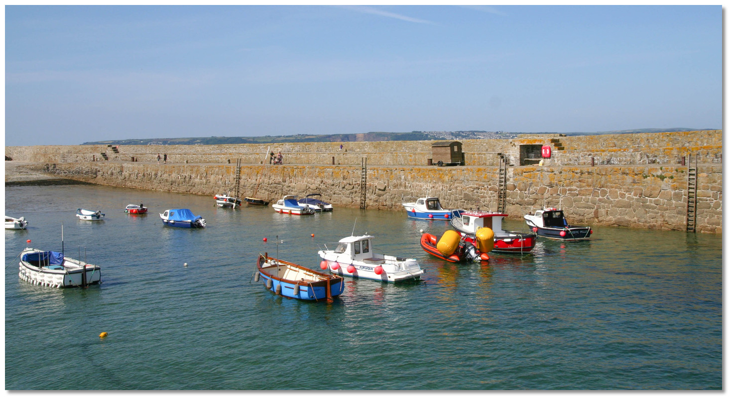
 The anchoring area with Great Hogus and Little Hogus exposed
Image: Kathryn
The anchorage lies in 2 to 3 metres between the Great Hogus Reef and the western pierhead. A firm sandy bottom provides excellent holding. Anchor clear of the obstruction, which lies about 100 metres out from the pier wall and about three-quarters of the way along its length.  The entrance to the harbour
Image: Kathryn
The harbour will be accessible to most average draught boats from half tide onward. Depths shelve gradually to about 100 metres west of the pierhead after which it becomes the same as at the entrance, ie 4.8 metres at high-water springs and 3.6 metres at neaps. Keep off the pierheads and clear of the ferry boats when passing in. The ferries tend to come alongside on the east side of the harbour mouth, which has the harbour's deepest water.
 The west wall with its ample ladders
Image: Kathryn
Come alongside the ladders on the western wall and dry out on hard sand or as directed by the harbourmaster. Make certain to use adequate fenders as the harbour is subject to a fore-and-aft surge that tends to roll fenders up, exposing the topsides to its rough granite wall.
Why visit here?
St Michael's Mount, the most prominent object for many miles out to sea, was believed to be the original Marazion, from the Hebrew marath-aiyin, meaning the landmark. If that were the case, its name was changed in AD 495, after fishermen claimed to have seen an apparition of the Archangel St Michael, the patron saint of fishermen, standing high on a rocky ledge on the western side of the Mount. The legend brought with it the name, along with pilgrims, monks and others of faith, to pray, praise and celebrate. St Michael's Mount today at dusk
Image: Public Domain
Its name in Cornish, however, remained Karrek Loos yn Koos, meaning the grey rock in the wood. The seems very odd considering its present appearance, but not so in prehistoric times. The Mount was indeed a sharp hill surrounded by forest until the grounds at its feet were covered by an inundation almost four millennia ago. At that time, the land extended nearly six miles south of the Mount and to a line from Mousehole to Cudden Point. When gales strip away the sands of the seabed during low tides, fragments of its hazelwood forest still appear from time to time. Radiocarbon dating of these has established that the submergence took place around 1700 BC. Nearby Scilly also suffered from this inundation. It was prehistorically one large island and there are various points around the islands’ coastline where Bronze Age fields have been drowned by the rising tide. So, it would appear that the Cornish name may represent an authentic folk memory of a time before Mount's Bay was flooded.
 Tristan and Isolde by Herbert James Draper
Image: Public Domain
Here the Atlantis myth and the Cornish belief in the lost land of Lyonesse, in Cornish Lethowsow, intertwine. It is one of Cornwall’s oldest legends and particular to the tragic love-saga of the adulterous love between the Cornish knight Tristan and the Irish princess Iseult of Arthurian legend. There are no references to the sinking of Lyonesse in the Arthurian tale because Lyonesse, then stretching from the land of Belerion (Cornwall) to the Isles of Scilly, was a beautiful land still in existence. Sometime after Tristan inherited the kingdom from King Arthur it was suddenly engulfed by the sea in a great storm leaving just one survivor. Luckily Tristran was at the court of his uncle at the time and only one man survived the flood. His name was Trevilian who managed to outrode the advancing waves that engulfed the fabled land and its 140 churches on a swift white horse. Trevilian took refuge in a cave near Marazion and his descendants, the aristocratic Trevelyan family, still bear a white horse rising from the waves on their family crest. There is however no evidence to suggest that Lyonesse ever existed although local fishermen swear that submerged buildings can sometimes be seen around the Seven Stones Lighthouse. Historically the Fishermen have call the spot 'The City'. It is also said that from Land’s End you can still sometimes hear the tolling of sunken church bells of Lyonesse on the evening breeze.
 St Michael's Mount as painted by William Anslow Thornley James in the 19th century
Image: Public Domain
Rising so abruptly and beautifully from either a forest or the sea, St Michael’s Mount would always have been a focus for human activity. Its possession would not only have conferred the greatest of local prestige, but would have provided its holder with a virtually impregnable stronghold, particularly so after the sea had replaced the forest. A leaf-shaped flint arrowhead found in a shallow pit on the lower eastern slope, now part of the modern gardens, has been dated back to Neolithic times, c 4000 to 2500 BC. Other pieces of flint are believed to have come from the Mesolithic period, c 8000 to 3500 BC, when it is expected that the Mount supported either a seasonal or short-term camp.
 St Michael's Mount as painted by James Webb in the 1890s
Image: Public Domain
St Michael's Mount is believed to have been a trading post from the earliest times, becoming an important port by the Iron Age. The Mount is one of several candidates for the island of Ictis, or Iktin, wherein the fourth-century BC Greek traders settled and dispatched Cornish tin to the Mediterranean. Diodorus Siculus, a Sicilian-Greek historian, writing in his Bibliotheca Historica during the early years of the first century BC, gives an account of the island. In it, he described how the inhabitants of Belerion (thought to be Land’s End) went about tin streaming and used wagons to carry the hard-won minerals across to the island of Ictis. The text also described the principal feature of the trading station: that it was an agreed and distinctive location separate from the worlds of both sets of traders, tin producers and buyers – a neutral port of trade. The early tin streamers used wagons to bring the tin to the island, which in the case of the Mount would have avoided the treacherous journey around Land's End or indeed the Lizard. These wagons would cross to the island of Ictis during the ebb of the tide, when the intervening space is left dry, to trade with the waiting merchants. All present a strong case that St Michael's Mount was the tin trading centre.
 A Victorian postcard of St Michael's Mount
Image: Michael Harpur
The finding of a Roman coin of Tetricus I, from AD 270-273, in the harbour in the early 20th century could be evidence for the Mount continuing as a trading station from the days of Ictis into the Roman period. Its impressive shape, defensibility and strategic location have given rise to a suggestion that it may have been a post-Roman citadel, similar to Tintagel. It is likely that secular occupation continued throughout the early medieval period, possibly associated with an early Christian centre.
 The impressive castle on the Mount
Image: Public Domain
Throughout the later Middle Ages, St Michael's Mount was seen as a Cornish counterpart of Mont Saint-Michel in Normandy, France. The French site is more significant, however, with 247 acres as opposed to 57, but the two do have a lot in common. Both are conical-shaped islands close to the mainland and formerly inaccessible at high tide. This made them easy to defend, and each has a wealth of military history. The locations became religious sites dedicated to the Archangel Michael, and it is believed that both of the religious communities were originally founded by monks from Ireland. Finally, each was home to a monastic community at the time of the Norman conquest, and it was this invasion that would closely bind them.
 The gardens on St Michael's Mount
Image: Public Domain
The Abbey of Saint-Michel supported William’s claim to the English throne and, after the conquest, St Michael’s Mount was given to them as a reward. This was most likely done by Count Robert of Mortain, William’s half-brother, who fought at Hastings under a banner bearing an image of St Michael and was rewarded with huge landholdings in England. This included most of Cornwall as he was bestowed the title Earl of Cornwall. Robert granted St Michael’s Mount to the Norman Abbey of Mont St Michael. By 1135, French Abbot Bernard le Bec had built a Benedictine monastery modelled on its French counterpart, and the two houses prospered as places of pilgrimage. The destination of the St Micheal's Mount pilgrimages would be Kader Migell, a difficult-to-reach stone seat that the saint was reputed to have left there. Sitting on the seat is the traditional end of the pilgrimage. Four miracles were said to have occurred here during 1262 and 1263, which only added to the religious magnetism that drew pilgrims from far and wide.
 Mount St Michael's small harbour
 Image: Stephen Colebourne
But being such a significant landmark meant it would never entirely be a place of peace and prayer. While King Richard I was on a Crusade in the Holy Land, the Mount was seized and held as a fortress by a group of his brother John's supporters. The buildings later returned to their monastic use, and by the early 14th century, the harbour had been established. The Mount was garrisoned during the wars against France, and in 1414 Henry V appropriated it as an alien priory. It was used as a fortress in the Wars of the Roses and the Cornish Rebellion against Edward VI. Then in the late 15th century, it was besieged while in the hands of the Earl of Oxford and, in 1497, Perkin Warbeck, pretender to the English throne, refortified the Mount. The monastery was finally dissolved by Henry VIII in 1539 during the Reformation.
 Boats in the harbour with the island 'hobbler' ferries on moorings
The fender pattern to deal with the fore-and-aft surge
Image: Stephen Colebourne
It was here that the first beacon was lit warning of the arrival of the Spanish Armada, while the Mount was garrisoned during the wars against France. The last occasion it was used in a military capacity was in 1646 during the English Civil War. The Royalists held the Mount for four years, and it provided an ideal place for the import and stockpiling of arms and ammunition brought in from France. Even by then, however, the technology of war had moved on and the military significance of the Mount had long since dissipated. This was accurately summed up by Parliamentarian John Taylor's derisive observation after the Royalist surrender in 1646, when he declared it was "not worth the taking or keeping".
 Walking across the stone-paved causeway at low water
Image: Fuzzypiggy via ASA 4.0
The Mount was bought during the 1660s by Sir John St Aubyn, its last military commander, and since that time it has had a peaceful existence. In 1727 the small harbour was rebuilt and extended, and in the middle of that century it underwent several further improvements. By the early 1800s it was filled with boats loading cargoes of copper, tin and cured fish, to return with coal, salt and Scandinavian timber. This activity sustained a population of about 300, who lived in 50 houses on the island and were supported by several schools and a chapel. In 1823 the entrance was enlarged to accommodate vessels of up to 500 tons.
 A hobbler ferry at high water
Image: Michael Harpur
In 1964 St Michael’s Mount was transferred to the National Trust. Since then the Aubyn family and the trust have preserved the island and its buildings for the nation. The north side is still home to around 30 people, who live in the cottages overlooking the harbour, with at least one person from each household working on the island, either in the gardens, in the house or on the water.
 An anchorage with the most spectacular vista
Image: Michael Harpur
From a boating point of view, St Michael's Mount could never be described as a great berth, either outside or inside its harbour. It is, however, one of the most famous of Cornwall's landmarks, often described as the jewel in its crown, and it provides an awe-inspiring location to haul up. Those who land here will have a complete family day out enjoying a fascinating history that is steeped in legend. Furthermore, there is a spectacular castle complete with gardens to explore. The Mount has something for everyone.
What facilities are available?
Water is available from the harbourmaster and the National Trust operate a restaurant, cafe and gift shop by the harbour. Most normal provisions including a post office and several pubs can be found at Marazion.With thanks to:
eOceanicAerial views of Saint Michael's Mount
Historic overview
About Saint Michael's Mount
St Michael's Mount, the most prominent object for many miles out to sea, was believed to be the original Marazion, from the Hebrew marath-aiyin, meaning the landmark. If that were the case, its name was changed in AD 495, after fishermen claimed to have seen an apparition of the Archangel St Michael, the patron saint of fishermen, standing high on a rocky ledge on the western side of the Mount. The legend brought with it the name, along with pilgrims, monks and others of faith, to pray, praise and celebrate.
St Michael's Mount today at duskImage: Public Domain
Its name in Cornish, however, remained Karrek Loos yn Koos, meaning the grey rock in the wood. The seems very odd considering its present appearance, but not so in prehistoric times. The Mount was indeed a sharp hill surrounded by forest until the grounds at its feet were covered by an inundation almost four millennia ago. At that time, the land extended nearly six miles south of the Mount and to a line from Mousehole to Cudden Point. When gales strip away the sands of the seabed during low tides, fragments of its hazelwood forest still appear from time to time. Radiocarbon dating of these has established that the submergence took place around 1700 BC. Nearby Scilly also suffered from this inundation. It was prehistorically one large island and there are various points around the islands’ coastline where Bronze Age fields have been drowned by the rising tide. So, it would appear that the Cornish name may represent an authentic folk memory of a time before Mount's Bay was flooded.
Tristan and Isolde by Herbert James DraperImage: Public Domain
Here the Atlantis myth and the Cornish belief in the lost land of Lyonesse, in Cornish Lethowsow, intertwine. It is one of Cornwall’s oldest legends and particular to the tragic love-saga of the adulterous love between the Cornish knight Tristan and the Irish princess Iseult of Arthurian legend. There are no references to the sinking of Lyonesse in the Arthurian tale because Lyonesse, then stretching from the land of Belerion (Cornwall) to the Isles of Scilly, was a beautiful land still in existence. Sometime after Tristan inherited the kingdom from King Arthur it was suddenly engulfed by the sea in a great storm leaving just one survivor. Luckily Tristran was at the court of his uncle at the time and only one man survived the flood. His name was Trevilian who managed to outrode the advancing waves that engulfed the fabled land and its 140 churches on a swift white horse. Trevilian took refuge in a cave near Marazion and his descendants, the aristocratic Trevelyan family, still bear a white horse rising from the waves on their family crest. There is however no evidence to suggest that Lyonesse ever existed although local fishermen swear that submerged buildings can sometimes be seen around the Seven Stones Lighthouse. Historically the Fishermen have call the spot 'The City'. It is also said that from Land’s End you can still sometimes hear the tolling of sunken church bells of Lyonesse on the evening breeze.
St Michael's Mount as painted by William Anslow Thornley James in the 19th centuryImage: Public Domain
Rising so abruptly and beautifully from either a forest or the sea, St Michael’s Mount would always have been a focus for human activity. Its possession would not only have conferred the greatest of local prestige, but would have provided its holder with a virtually impregnable stronghold, particularly so after the sea had replaced the forest. A leaf-shaped flint arrowhead found in a shallow pit on the lower eastern slope, now part of the modern gardens, has been dated back to Neolithic times, c 4000 to 2500 BC. Other pieces of flint are believed to have come from the Mesolithic period, c 8000 to 3500 BC, when it is expected that the Mount supported either a seasonal or short-term camp.
St Michael's Mount as painted by James Webb in the 1890sImage: Public Domain
St Michael's Mount is believed to have been a trading post from the earliest times, becoming an important port by the Iron Age. The Mount is one of several candidates for the island of Ictis, or Iktin, wherein the fourth-century BC Greek traders settled and dispatched Cornish tin to the Mediterranean. Diodorus Siculus, a Sicilian-Greek historian, writing in his Bibliotheca Historica during the early years of the first century BC, gives an account of the island. In it, he described how the inhabitants of Belerion (thought to be Land’s End) went about tin streaming and used wagons to carry the hard-won minerals across to the island of Ictis. The text also described the principal feature of the trading station: that it was an agreed and distinctive location separate from the worlds of both sets of traders, tin producers and buyers – a neutral port of trade. The early tin streamers used wagons to bring the tin to the island, which in the case of the Mount would have avoided the treacherous journey around Land's End or indeed the Lizard. These wagons would cross to the island of Ictis during the ebb of the tide, when the intervening space is left dry, to trade with the waiting merchants. All present a strong case that St Michael's Mount was the tin trading centre.
A Victorian postcard of St Michael's MountImage: Michael Harpur
The finding of a Roman coin of Tetricus I, from AD 270-273, in the harbour in the early 20th century could be evidence for the Mount continuing as a trading station from the days of Ictis into the Roman period. Its impressive shape, defensibility and strategic location have given rise to a suggestion that it may have been a post-Roman citadel, similar to Tintagel. It is likely that secular occupation continued throughout the early medieval period, possibly associated with an early Christian centre.
The impressive castle on the MountImage: Public Domain
Throughout the later Middle Ages, St Michael's Mount was seen as a Cornish counterpart of Mont Saint-Michel in Normandy, France. The French site is more significant, however, with 247 acres as opposed to 57, but the two do have a lot in common. Both are conical-shaped islands close to the mainland and formerly inaccessible at high tide. This made them easy to defend, and each has a wealth of military history. The locations became religious sites dedicated to the Archangel Michael, and it is believed that both of the religious communities were originally founded by monks from Ireland. Finally, each was home to a monastic community at the time of the Norman conquest, and it was this invasion that would closely bind them.
The gardens on St Michael's MountImage: Public Domain
The Abbey of Saint-Michel supported William’s claim to the English throne and, after the conquest, St Michael’s Mount was given to them as a reward. This was most likely done by Count Robert of Mortain, William’s half-brother, who fought at Hastings under a banner bearing an image of St Michael and was rewarded with huge landholdings in England. This included most of Cornwall as he was bestowed the title Earl of Cornwall. Robert granted St Michael’s Mount to the Norman Abbey of Mont St Michael. By 1135, French Abbot Bernard le Bec had built a Benedictine monastery modelled on its French counterpart, and the two houses prospered as places of pilgrimage. The destination of the St Micheal's Mount pilgrimages would be Kader Migell, a difficult-to-reach stone seat that the saint was reputed to have left there. Sitting on the seat is the traditional end of the pilgrimage. Four miracles were said to have occurred here during 1262 and 1263, which only added to the religious magnetism that drew pilgrims from far and wide.
Mount St Michael's small harbour Image: Stephen Colebourne
But being such a significant landmark meant it would never entirely be a place of peace and prayer. While King Richard I was on a Crusade in the Holy Land, the Mount was seized and held as a fortress by a group of his brother John's supporters. The buildings later returned to their monastic use, and by the early 14th century, the harbour had been established. The Mount was garrisoned during the wars against France, and in 1414 Henry V appropriated it as an alien priory. It was used as a fortress in the Wars of the Roses and the Cornish Rebellion against Edward VI. Then in the late 15th century, it was besieged while in the hands of the Earl of Oxford and, in 1497, Perkin Warbeck, pretender to the English throne, refortified the Mount. The monastery was finally dissolved by Henry VIII in 1539 during the Reformation.
Boats in the harbour with the island 'hobbler' ferries on mooringsThe fender pattern to deal with the fore-and-aft surge
Image: Stephen Colebourne
It was here that the first beacon was lit warning of the arrival of the Spanish Armada, while the Mount was garrisoned during the wars against France. The last occasion it was used in a military capacity was in 1646 during the English Civil War. The Royalists held the Mount for four years, and it provided an ideal place for the import and stockpiling of arms and ammunition brought in from France. Even by then, however, the technology of war had moved on and the military significance of the Mount had long since dissipated. This was accurately summed up by Parliamentarian John Taylor's derisive observation after the Royalist surrender in 1646, when he declared it was "not worth the taking or keeping".
Walking across the stone-paved causeway at low waterImage: Fuzzypiggy via ASA 4.0
The Mount was bought during the 1660s by Sir John St Aubyn, its last military commander, and since that time it has had a peaceful existence. In 1727 the small harbour was rebuilt and extended, and in the middle of that century it underwent several further improvements. By the early 1800s it was filled with boats loading cargoes of copper, tin and cured fish, to return with coal, salt and Scandinavian timber. This activity sustained a population of about 300, who lived in 50 houses on the island and were supported by several schools and a chapel. In 1823 the entrance was enlarged to accommodate vessels of up to 500 tons.
A hobbler ferry at high waterImage: Michael Harpur
In 1964 St Michael’s Mount was transferred to the National Trust. Since then the Aubyn family and the trust have preserved the island and its buildings for the nation. The north side is still home to around 30 people, who live in the cottages overlooking the harbour, with at least one person from each household working on the island, either in the gardens, in the house or on the water.
An anchorage with the most spectacular vistaImage: Michael Harpur
From a boating point of view, St Michael's Mount could never be described as a great berth, either outside or inside its harbour. It is, however, one of the most famous of Cornwall's landmarks, often described as the jewel in its crown, and it provides an awe-inspiring location to haul up. Those who land here will have a complete family day out enjoying a fascinating history that is steeped in legend. Furthermore, there is a spectacular castle complete with gardens to explore. The Mount has something for everyone.
Other options in this area
Click the 'Next' and 'Previous' buttons to progress through neighbouring havens in a coastal 'clockwise' or 'anti-clockwise' sequence. Alternatively here are the ten nearest havens available in picture view:
Coastal clockwise:
Penzance Harbour - 1.2 miles WNewlyn - 1.7 miles WSW
Mousehole - 2 miles SW
Perpitch - 19.7 miles WSW
Higher Town Bay - 20.1 miles WSW
Coastal anti-clockwise:
Porthleven Harbour - 4.1 miles ESEMullion Cove & Porth Mellin - 6.5 miles SE
Kynance Cove - 8.1 miles SE
Cadgwith - 8.7 miles SE
Coverack - 9.9 miles ESE
Navigational pictures
These additional images feature in the 'How to get in' section of our detailed view for Saint Michael's Mount.


| Detail view | Off |
| Picture view | On |
Aerial views of Saint Michael's Mount
Historic overview
Add your review or comment:
Please log in to leave a review of this haven.
Please note eOceanic makes no guarantee of the validity of this information, we have not visited this haven and do not have first-hand experience to qualify the data. Although the contributors are vetted by peer review as practised authorities, they are in no way, whatsoever, responsible for the accuracy of their contributions. It is essential that you thoroughly check the accuracy and suitability for your vessel of any waypoints offered in any context plus the precision of your GPS. Any data provided on this page is entirely used at your own risk and you must read our legal page if you view data on this site. Free to use sea charts courtesy of Navionics.