

Penzance Harbour is situated in the northwest part of Penzance Bay on England’s southwest coast, about 15 miles northwest of Lizard Point and 8 miles northeast of Land’s End. It is a small drying port that offers pleasure craft the potential of locking-in to its wet dock, anchoring outside in settled conditions or picking up one of its tide-wait moorings overnight. Drying moorings may also be available in its tidal harbour.
The wet dock offers complete protection from all conditions, but its gate opens only for a quarter of the tidal cycle. Access is straightforward night or day, near high water for those intending to enter the harbour. Although Penzance provides complete protection, it should be not considered a ‘harbour of refuge’ during strong south round to east winds. At these times waves break across its shallow entrance barring entry. Newlyn Harbour provides the only safe option in the bay, though preferably at high water.

Keyfacts for Penzance Harbour


Last modified
March 5th 2020 Summary* Restrictions apply
A completely protected location with straightforward access.Facilities


Nature


Considerations


 +447779 264335
Position and approaches

Expand to new tab or fullscreen
Haven position
 50° 7.062' N, 005° 31.678' W
This is the position of the Penzance’s iron lighthouse on the head of South Pier. It is 11 metres high, coloured white with a black bottom band, Fl. WR.5s. It can be seen for 17/12 miles, with the red sector showing over The Gear and the Cressars.
What is the initial fix?
The following Penzance Harbour Initial Fix will set up a final approach:
 50° 6.640' N, 005° 30.830' W

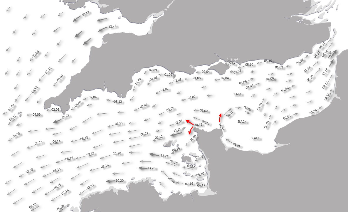


What are the key points of the approach?
Offshore details are available in southwest England’s coastal overview from Lizard Point to Land’s End  . For local approaches see Newlyn
  .
.
. For local approaches see Newlyn .- Approach from southeast, steering for the lighthouse at the head of the South Pier.
- Continue in staying well clear of The Gear and the Cressars at the head of the bay.
Not what you need?
Click the 'Next' and 'Previous' buttons to progress through neighbouring havens in a coastal 'clockwise' or 'anti-clockwise' sequence. Below are the ten nearest havens to Penzance Harbour for your convenience.
Ten nearest havens by straight line charted distance and bearing:
- Newlyn - 1 nautical miles SSW
- Saint Michael's Mount - 1.9 nautical miles E
- Mousehole - 2.1 nautical miles S
- Porthleven Harbour - 8.4 nautical miles ESE
- Mullion Cove & Porth Mellin - 12 nautical miles ESE
- Kynance Cove - 14.5 nautical miles SE
- Helford River - 15.4 nautical miles E
- Cadgwith - 15.6 nautical miles ESE
- Gillan Creek - 16.9 nautical miles E
- Coverack - 17.7 nautical miles ESE
These havens are ordered by straight line charted distance and bearing, and can be reordered by compass direction or coastal sequence:
- Newlyn - 1 miles SSW
- Saint Michael's Mount - 1.9 miles E
- Mousehole - 2.1 miles S
- Porthleven Harbour - 8.4 miles ESE
- Mullion Cove & Porth Mellin - 12 miles ESE
- Kynance Cove - 14.5 miles SE
- Helford River - 15.4 miles E
- Cadgwith - 15.6 miles ESE
- Gillan Creek - 16.9 miles E
- Coverack - 17.7 miles ESE


What's the story here?
 Penzance Harbour
Image: Michael Harpur
Penzance Harbour is situated in the extreme northwest part of Penzance Bay. Penzance is the most southwesterly town of not only Cornwall, but of Britain as a whole. Its harbour is formed by two outer piers, within which there is a wet dock basin and a tidal basin, which mostly dries except for the ro-ro berth. The first (or northern) pier is called Albert Pier and runs out 250 metres in a southwesterly direction from the mainland. The South Pier extends from the wet dock and runs out northeasterly for 100 metres, at the end of which you will find the conspicuous iron lighthouse. The pier is the terminal of the Scillonian ferry and its inner side is called the Ferry Berth. The ferry runs to the Scilly Islands and the lion’s share of the wet dock’s supplies and freight is transited between here and the island group. Being home to 240 drying moorings for residents’ recreational craft, with the wet dock having berths for up to 50 visiting yachts, the harbour is a busy yachting centre. Alongside this activity are some modest fish landings.
 The wet dock gate closed with yachts rafted in the basin
Image: Michael Harpur
The wet dock gate is 15.3 metres wide and opens from HW-0200 to HW+0100, when it usually has a depth of 4.3 metres inside the basin. It can accommodate up to 50 visiting boats and vessels up to 92 metres in length.
 The wet dock gate overlooked by the Harbour Office
Image: Michael Harpur
Boats should prepare to raft several boats deep in the wet basin. Ten orange visitor buoys, located south of the South Pier, can be used while waiting for the tide, or overnight during settled conditions. It is also possible to anchor eastward of the end of Albert Pier, taking care not obstruct the harbour entrance. This is a good anchorage in winds from southwest to west round to the north.
 Yachts alongside in the wet dock
Image: Michael Harpur
Penzance Harbour office can be contacted on
 Ch. 12 [Penzance Harbour],
  +44 1736 366113 during office hours and any time the wet dock is open. Harbour fees for visiting boats [2019]: Inner harbour wet dock – £15 per night, with a concessionary ticket of 10 visits, each of up to 24 hours – £120; outer tidal harbour – £12 per night, with a concessionary ticket of 10 visits – £96.
How to get in?
 Penzance Harbour in the northwest part of Penzance Bay
Image: Michael Harpur
 Use southwest England’s coastal overview from Lizard Point to Land’s End for seaward approaches and Newlyn for local approaches. Keep a sharp eye out for pot marker buoys throughout this area. The primary danger is The Gear rock that lies about ½ mile south of the harbour entrance. It dries to 1.9 metres and is marked by an isolated danger beacon Fl(2)10s. It is best to keep south of a line joining the pierhead of Penzance and the summit of Saint Michael’s Mount to keep offshore of the reefs and foul ground that front the head of Penzance Bay.
 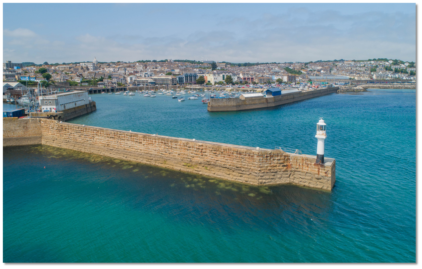 The South Pier with its conspicuous iron lighthouse
Image: Michael Harpur
 From the initial fix, the 9-metre lighthouse, coloured white with a black bottom band, will be seen standing on the head of the south breakwater. A church with a prominent tower will be seen standing close west of the wet dock basin, while the dome of the market, situated about ⅓ mile northwest of the wet dock basin will also be conspicuous. It is important not to confuse the harbour with Newlyn, which can also be seen a mile to the southwest.
 At night, Penzance exhibits a sectored light, Fl WR 5s, white 268°-345° T 17M, red 159°-268°T 12M, with the red sector showing over The Gear and the Cressars. Likewise, do not confuse this with the lighthouse, Fl5s10m9m, on the head of Newlyn’s South Pier.
Steer for the lighthouse during the day and keep in the white sector at night. This passes well clear of The Gear and outside the Battery Rocks, which lie south by southeast of the entrance, extending almost halfway from the shore to the former.
 Yacht at anchor eastward of the head of Albert Pier
Image: Michael Harpur
Sound in and anchor eastward of the head of Albert Pier in approximately 1.5-2m LAT, taking care not to obstruct the entrance. Alternatively, anchor south of the South Pier, clear of the moorings.  Yacht on a tide-wait buoy outside the harbour
Image: Michael Harpur
It is also possible to await the tide or stay overnight in fine weather by picking up any of the orange moorings, located in about 2 metres LAT to the south of the South Pier. Winds are generally from the north to northeast in the morning and tend to turn south to southwest in the afternoon.
 The Scillonian alongside
Image: Michael Harpur
The Scillonian ferry is usually away the whole day during the week, but is in around midday on Saturday and all day on Sunday, when there is no service. It may be possible by arrangement with the harbourmaster, to come alongside and tide-wait on the Ferry Berth, where at least 1.8 metres will be found from the middle of the pier outward. Further in, close along the South Pier, the channel has 0.6 metres LAT up to the lock gates.
 Be prepared to raft up in the wet dock
Image: Michael Harpur
At high water, enter the harbour and berth by prior arrangement with the harbourmaster. At night, a signal mast outside the harbourmaster’s office, on the north side of dock’s entrance, shows when the wet dock gate is open 3F.G(vert), closed 3F.R(vert).
Why visit here?
Penzance, first recorded as Pensans in 1284, takes its name from the conjunction of the Cornish words penn and sans, meaning ‘holy headland’. The name refers to the location of a chapel, thought nowadays to be St Anthony’s, which is said to have stood for over a thousand years on the headland to the west of what would become Penzance Harbour.The Land’s End peninsula is well known for its prehistoric human inhabitation. The landscape is littered with Neolithic-Bronze Age granite-walled tombs and monuments from over 5,000 years ago. From this time to the present, the sheltered and fertile coastal plains and the lowlands east of the hills around Penzance would have been the most attractive area for inhabitation. Substantial physical evidence of occupation during the Iron Age and Roman period has been found in the town’s surrounds. The earliest evidence of settlement in Penzance comes in the form of Bronze Age artefacts, such as a palstave (a type of chisel), a spearhead, a knife, pins and several items of pottery.
 Bronze Age stone circle ‘The Merry Maidens’, near Penzance
Image: Richard-sr via CC ASA 3.0
West of the present urban core, in or near the valley of the Lariggan stream, was the site of Alverton, which was the original manorial centre of the area and the largest of the Land’s End peninsula. The names of both the manor and stream speak to the area’s history. Alward, a person’s name, combines with tun, meaning a small town, to give the settlement of a Saxon called Alward. The river name is a conjunction of lann, indicating an early Christian site, and mennaye, Cornish for monks, indicating its banks were monks’ church land. It is possible that this monastic settlement predated St Anthony’s church and could, instead, be the origin of the ‘Holy Headland’ place name.
.jpg) A French ship under attack from Barbary Pirates (circa 1615)
A French ship under attack from Barbary Pirates (circa 1615)Image: Public Domain
Because Penzance did not exist in 1066, Domesday recorded only the Manor of Alwarton and that it was owned by Alward. Alward, however, was soon to be dispossessed when, after the conquest, Cornwall was given to Robert, Count of Mortain, half-brother of William the Conqueror. This would have meant little to the local population as it was just a matter of one invader being replaced by another. The first reference to Penzance as a settlement comes in an Alverton manorial survey dated 1322, which refers to 29 burgesses, eight boats and several ‘lodges’ (fish cellars) for ‘foreign’ fishermen. A decade later it was given a charter that allowed for a weekly market and an annual fair lasting seven days. With an established charter, people came from all over Cornwall to buy and sell their goods at a Penzance fair.
 Christian slaves in Algiers as late as the 19th century
Image: Public Domain
During the 14th century, Penzance grew from a village into a small town that, having the deepest most sheltered water in the bay, was fronted by a busy little port. To accommodate the growing level of activity, in 1404 Henry IV granted the town a royal market, allowing for two weekly markets and three annual fairs. The royal market, together with the harbour, started the engine that would drive the town’s prosperity throughout its history. This development was further fuelled in 1512 when Henry VIII granted the tenants of Penzance whatever profits might accrue from the ‘ankerage, kylage and busselage‘ of ships, so long as they should repair and maintain the quay and bulwarks for the safeguard of the ships and town. Until then, the combined trade of the neighbouring town of Marazion and the pier at St Michael’s Mount had been regarded as the port of Mounts Bay – but from this point onward, Penzance would always be of greater mercantile importance.
It is not known when the first quay was built at Penzance, but by the start of the 15th century it had six full-time fishing boats, and it had licensed ships ferrying pilgrims from St Michael’s Mount to the shrine of St James of Compostella, in northwest Spain. The earliest record of a quay at Penzance comes from the time when Henry VIII granted it harbour dues, but it also referred to repair works of an existing 15th-century structure.
 Depiction of the Spanish attack in 1595
Image: Public Domain
What might be the earliest bulwarks or defences at the Barbican were noted at this time, as this was a dangerous coast. It would suffer the scourge of frequent raids by ‘Turkish pirates‘ – Barbary Corsairs, in fact, who would disappear as much as 20 per cent of Cornwall and Devon’s seamen. In 1595, Penzance, Newlyn and Mousehole were invaded by four Spanish galleys in the aftermath of their ill-fated Armada. They looted the town, burned 400 houses and sunk three ships ‘laden with wine and other goods‘ in the harbour; few Medieval and Tudor buildings survived this experience. While these invaders were soon despatched, this event marked the last time that Cornwall was to be invaded by hostile forces. However, the sheltered and isolated bay at England’s southwest extremity remained highly exposed to raids by French warships and Breton pirates. It was for this reason that it was chosen by Gilbert and Sullivan to be the location for the operetta The Pirates of Penzance.
 Penzance between 1890 and 1900
Image: Public Domain
Penzance, though, had an uncanny knack of turning short-term misfortune into long-term advantage, and largely by the intervening hand of a King. In 1614, King James I granted the town the status of a borough. The charter of incorporation stated that ‘by the invasion of the Spaniards it had been treacherously spoiled and burnt but that its strength, prosperity and usefulness for navigation, and the acceptable and laudable services of the inhabitants in rebuilding and fortifying it, and their enterprise in erecting a pier, have moved the king to grant the petition for its incorporation’. With a mayor and corporation, Penzance was now a ‘proper’ town and, indeed, established itself as one of the principal towns in the west during the 16th, 17th and 18th centuries.
 The Turk’s Head Inn has been serving customers since the Crusades
Image: Mike Smith via CC BY-SA 2.0
These benefits instilled a deep gratitude for the royalty, a fact that put it on the wrong side of history during the Civil War. When the war ended in 1646, Penzance was sacked by the Parliamentary forces of Sir Thomas Fairfax. In 1648, there was an uprising in the town in support of the king, but it was quickly defeated by Parliamentary soldiers, who once again sacked the town. Once again, this loyalty would not be overlooked, and the re-established King Charles I made Penzance a coinage, or Stannary, town in 1663.
 The town slopes upward from the harbour
Image: Michael Harpur
This was a privileged centre where refined (or white) tin was assessed, coined and sold. The process was achieved by having a corner or ‘coin’ removed from a shipment to check its quality before it was sold and exported. The activity brought with it the institutions associated with the industry, and bustling trade. The Corporation was vigorous in its promotion of the town and it became the customs port for the whole Mount’s Bay area, from Cape Cornwall to the Lizard. Timber, salt, iron and coal, alongside massive cargoes of grain in years of poor harvest, were imported. Pilchard fishing had thrived from the Tudor period onwards, and in later centuries much of the town’s trade was the export of salted fish, chiefly to Italy. Other exports included, of course, tin and copper, as well as granite, serpentine, vegetables and china clay.
 Albert Pier was completed in 1847
Image: Michael Harpur
Throughout the 17th and 18th centuries, Penzance prospered as a market town and port. In 1724, Daniel Defoe noted: ‘Penzance is... a place of good business... well built and prosperous, has a good trade, and a great many ships belonging to it... Here are also a great many good families of gentlemen....’ The constant theme for these centuries was development. The streets of Penzance were soon paved, unlike many towns of the time. In 1769, it was visible that Penzance was a ‘place of considerable note‘. Penzance was also home to the first lifeboat in Cornwall in 1803, while the status of the town and its high-value trade made it attractive not only for merchants and businessmen, but also to the local gentry. It became the social and cultural centre of the far west and many of the Cornish gentry owned a second house in the town. By the 18th century, the wealthy and expanding town’s commercial success and elegance gained it the epithet of ‘Montpellier of England’. This gave rise, in part, to the rich architectural heritage of delightful Georgian and Regency buildings that survive to this day.
 Penzance’s iron lighthouse was built in 1855
Image: Michael Harpur
By the time Victoria came to the throne in 1837, Penzance had established itself as an important regional centre. The port continued to boom, tin still being the main export, and it was about to receive some major Victorian development. The Albert Pier was built in 1847 and in 1853 the old South Pier was extended, its lighthouse being finally established in 1855. These facilities proved valuable in supporting the steamships that were soon calling at the harbour in increasing numbers. There was also a shipbuilding industry in Penzance in the 19th century, with various small industries around the town servicing the harbour or the local mining and agricultural hinterland.
 Lloyds Bank on Penzance High Street
Image: Roger Cornfoot via CC BY-SA 2.0
In 1852 a railway line was established from Penzance to Redruth and by 1866 Penzance was linked directly to London, making it efficient to transport goods to the capital. This was of enormous value to Penzance as it meant that perishable products could be transported to their end consumers within a day. The rail link stimulated extensive market gardening that leveraged the bay’s uniquely mild climate. Great quantities of early potatoes and other vegetables, together with flowers and fish, were sent to London and elsewhere. Traffic went both ways, and by return came tourists keen to explore the ‘picturesque’ west. This return trade was very fortunate as the town’s traditional mainstays of the tin industry and fishing would soon go into steep decline.
 The dome of the Lloyds Bank building stands out prominently on the skyline
Image: Robert Pittman via CC BY-SA 2.0
Today, the key activities in Penzance comprise service, retail, public education and administration, leisure and tourism, as well as the still-working harbour. Penzance is large enough to preserve an independent identity and it feels one step removed from the rest of Cornwall. There are few better places to experience the sense of a big town in a small frame. This particularly applies to the most southwesterly town of not only of Cornwall but of Britain as a whole.
 Penlee House Museum and Gallery
Image: Roger Cornfoot via CC BY-SA 2.0
The town preserves a lively, unpretentious feel that combines a busy, working atmosphere with the trappings of the holiday industry. Most of the medieval town was unfortunately obliterated by the Spanish raid but ample handsome Georgian and Regency architecture remains. Its first-rate museum provides a fascinating insight into all its history and there is plenty in and around the town to keep a crew interested. The Turks Head inn should not be overlooked by the thirsty. The inn is reputed to date from 1233, when, during the crusades, it started slaking the thirst of sailors and has been doing so ever since.
 The Scillonian on the Ferry Berth
Image: Michael Harpur
From a boating perspective, the wet dock can be relied upon as somewhere secure to leave the boat unattended. This provides the perfect opportunity to endure some bad weather, with all the comforts of the town immediately to hand, or enjoy the town and use it as a useful starting point for forays to the nearby sights of the peninsula. It is also an ideal provisioning point or crew changeover location, with excellent rail connections. The single, slight disadvantage that it does have, is as a ‘passage-making harbour’. The opening times of the wet dock suit neither the nearby tidal gates of Land’s End or The Lizard, so there is some additional scheduling to be attended to before entering or leaving. Other than that, Penzance is a key boating location for this stretch of coast and a most enjoyable one.
What facilities are available?
Water is available on the quay, power via a card, and you can get diesel on South Pier and petrol by jerry can from nearby garages. The harbourmaster issues keys to the showers and toilets adjacent to the office. Calor/camping gas can be found at a nearby chandlery, while there is local cycle hire and internet facilities at the library.There are two slipways for trailer launches, one at Albert Pier, by the Penzance Sailing Club, and the second near the café and shell shop by the dry dock. Access is available for half the tidal range. There is a mobile 10-tonne crane that offers haul-out facilities, with sailmakers and general marine, electronics and engineering services in the vicinity. Penzance Sailing Club is based at the foot of Albert Pier,
+44 1736 364989,  www.pzsc.org.uk/.
The town itself presents a remarkably self-contained character. Being the main local shopping service centre for a wide area, it has a much greater range of facilities and services than might be expected for its size. It has all the major banks, with cashpoints, post office, supermarkets, multiples, specialist and local shops, as well as a wide range of commercial and business services. This makes it an ideal location for provisioning the boat, along with the crew in its numerous pubs and restaurants.
Penzance is the last stop on the main train line from London Paddington (6 hours, 8am to 10pm daily) via Truro. There are also frequent trains to St Ives (20 minutes, hourly). Penzance is also well-served by local buses: the 301 to St Ives (1hr 10m, at least hourly), and the No 1/1A to Land’s End (1 hour, 8am to midnight Monday to Saturday, five on Sunday) via Newlyn, Porthcurno, Sennen and Treen. The 18/X18 to Truro (hourly Monday to Saturday), and the National Express coach. The Scillonian offers a ferry service and Skybus flights to the Scilly Isles.
With thanks to:
eOceanicAbout Penzance Harbour
Penzance, first recorded as Pensans in 1284, takes its name from the conjunction of the Cornish words penn and sans, meaning ‘holy headland’. The name refers to the location of a chapel, thought nowadays to be St Anthony’s, which is said to have stood for over a thousand years on the headland to the west of what would become Penzance Harbour.
The Land’s End peninsula is well known for its prehistoric human inhabitation. The landscape is littered with Neolithic-Bronze Age granite-walled tombs and monuments from over 5,000 years ago. From this time to the present, the sheltered and fertile coastal plains and the lowlands east of the hills around Penzance would have been the most attractive area for inhabitation. Substantial physical evidence of occupation during the Iron Age and Roman period has been found in the town’s surrounds. The earliest evidence of settlement in Penzance comes in the form of Bronze Age artefacts, such as a palstave (a type of chisel), a spearhead, a knife, pins and several items of pottery.
Bronze Age stone circle ‘The Merry Maidens’, near PenzanceImage: Richard-sr via CC ASA 3.0
West of the present urban core, in or near the valley of the Lariggan stream, was the site of Alverton, which was the original manorial centre of the area and the largest of the Land’s End peninsula. The names of both the manor and stream speak to the area’s history. Alward, a person’s name, combines with tun, meaning a small town, to give the settlement of a Saxon called Alward. The river name is a conjunction of lann, indicating an early Christian site, and mennaye, Cornish for monks, indicating its banks were monks’ church land. It is possible that this monastic settlement predated St Anthony’s church and could, instead, be the origin of the ‘Holy Headland’ place name.
A French ship under attack from Barbary Pirates (circa 1615)Image: Public Domain
Because Penzance did not exist in 1066, Domesday recorded only the Manor of Alwarton and that it was owned by Alward. Alward, however, was soon to be dispossessed when, after the conquest, Cornwall was given to Robert, Count of Mortain, half-brother of William the Conqueror. This would have meant little to the local population as it was just a matter of one invader being replaced by another. The first reference to Penzance as a settlement comes in an Alverton manorial survey dated 1322, which refers to 29 burgesses, eight boats and several ‘lodges’ (fish cellars) for ‘foreign’ fishermen. A decade later it was given a charter that allowed for a weekly market and an annual fair lasting seven days. With an established charter, people came from all over Cornwall to buy and sell their goods at a Penzance fair.
Christian slaves in Algiers as late as the 19th centuryImage: Public Domain
During the 14th century, Penzance grew from a village into a small town that, having the deepest most sheltered water in the bay, was fronted by a busy little port. To accommodate the growing level of activity, in 1404 Henry IV granted the town a royal market, allowing for two weekly markets and three annual fairs. The royal market, together with the harbour, started the engine that would drive the town’s prosperity throughout its history. This development was further fuelled in 1512 when Henry VIII granted the tenants of Penzance whatever profits might accrue from the ‘ankerage, kylage and busselage‘ of ships, so long as they should repair and maintain the quay and bulwarks for the safeguard of the ships and town. Until then, the combined trade of the neighbouring town of Marazion and the pier at St Michael’s Mount had been regarded as the port of Mounts Bay – but from this point onward, Penzance would always be of greater mercantile importance.
It is not known when the first quay was built at Penzance, but by the start of the 15th century it had six full-time fishing boats, and it had licensed ships ferrying pilgrims from St Michael’s Mount to the shrine of St James of Compostella, in northwest Spain. The earliest record of a quay at Penzance comes from the time when Henry VIII granted it harbour dues, but it also referred to repair works of an existing 15th-century structure.
Depiction of the Spanish attack in 1595Image: Public Domain
What might be the earliest bulwarks or defences at the Barbican were noted at this time, as this was a dangerous coast. It would suffer the scourge of frequent raids by ‘Turkish pirates‘ – Barbary Corsairs, in fact, who would disappear as much as 20 per cent of Cornwall and Devon’s seamen. In 1595, Penzance, Newlyn and Mousehole were invaded by four Spanish galleys in the aftermath of their ill-fated Armada. They looted the town, burned 400 houses and sunk three ships ‘laden with wine and other goods‘ in the harbour; few Medieval and Tudor buildings survived this experience. While these invaders were soon despatched, this event marked the last time that Cornwall was to be invaded by hostile forces. However, the sheltered and isolated bay at England’s southwest extremity remained highly exposed to raids by French warships and Breton pirates. It was for this reason that it was chosen by Gilbert and Sullivan to be the location for the operetta The Pirates of Penzance.
Penzance between 1890 and 1900Image: Public Domain
Penzance, though, had an uncanny knack of turning short-term misfortune into long-term advantage, and largely by the intervening hand of a King. In 1614, King James I granted the town the status of a borough. The charter of incorporation stated that ‘by the invasion of the Spaniards it had been treacherously spoiled and burnt but that its strength, prosperity and usefulness for navigation, and the acceptable and laudable services of the inhabitants in rebuilding and fortifying it, and their enterprise in erecting a pier, have moved the king to grant the petition for its incorporation’. With a mayor and corporation, Penzance was now a ‘proper’ town and, indeed, established itself as one of the principal towns in the west during the 16th, 17th and 18th centuries.
The Turk’s Head Inn has been serving customers since the CrusadesImage: Mike Smith via CC BY-SA 2.0
These benefits instilled a deep gratitude for the royalty, a fact that put it on the wrong side of history during the Civil War. When the war ended in 1646, Penzance was sacked by the Parliamentary forces of Sir Thomas Fairfax. In 1648, there was an uprising in the town in support of the king, but it was quickly defeated by Parliamentary soldiers, who once again sacked the town. Once again, this loyalty would not be overlooked, and the re-established King Charles I made Penzance a coinage, or Stannary, town in 1663.
The town slopes upward from the harbourImage: Michael Harpur
This was a privileged centre where refined (or white) tin was assessed, coined and sold. The process was achieved by having a corner or ‘coin’ removed from a shipment to check its quality before it was sold and exported. The activity brought with it the institutions associated with the industry, and bustling trade. The Corporation was vigorous in its promotion of the town and it became the customs port for the whole Mount’s Bay area, from Cape Cornwall to the Lizard. Timber, salt, iron and coal, alongside massive cargoes of grain in years of poor harvest, were imported. Pilchard fishing had thrived from the Tudor period onwards, and in later centuries much of the town’s trade was the export of salted fish, chiefly to Italy. Other exports included, of course, tin and copper, as well as granite, serpentine, vegetables and china clay.
Albert Pier was completed in 1847Image: Michael Harpur
Throughout the 17th and 18th centuries, Penzance prospered as a market town and port. In 1724, Daniel Defoe noted: ‘Penzance is... a place of good business... well built and prosperous, has a good trade, and a great many ships belonging to it... Here are also a great many good families of gentlemen....’ The constant theme for these centuries was development. The streets of Penzance were soon paved, unlike many towns of the time. In 1769, it was visible that Penzance was a ‘place of considerable note‘. Penzance was also home to the first lifeboat in Cornwall in 1803, while the status of the town and its high-value trade made it attractive not only for merchants and businessmen, but also to the local gentry. It became the social and cultural centre of the far west and many of the Cornish gentry owned a second house in the town. By the 18th century, the wealthy and expanding town’s commercial success and elegance gained it the epithet of ‘Montpellier of England’. This gave rise, in part, to the rich architectural heritage of delightful Georgian and Regency buildings that survive to this day.
Penzance’s iron lighthouse was built in 1855Image: Michael Harpur
By the time Victoria came to the throne in 1837, Penzance had established itself as an important regional centre. The port continued to boom, tin still being the main export, and it was about to receive some major Victorian development. The Albert Pier was built in 1847 and in 1853 the old South Pier was extended, its lighthouse being finally established in 1855. These facilities proved valuable in supporting the steamships that were soon calling at the harbour in increasing numbers. There was also a shipbuilding industry in Penzance in the 19th century, with various small industries around the town servicing the harbour or the local mining and agricultural hinterland.
Lloyds Bank on Penzance High StreetImage: Roger Cornfoot via CC BY-SA 2.0
In 1852 a railway line was established from Penzance to Redruth and by 1866 Penzance was linked directly to London, making it efficient to transport goods to the capital. This was of enormous value to Penzance as it meant that perishable products could be transported to their end consumers within a day. The rail link stimulated extensive market gardening that leveraged the bay’s uniquely mild climate. Great quantities of early potatoes and other vegetables, together with flowers and fish, were sent to London and elsewhere. Traffic went both ways, and by return came tourists keen to explore the ‘picturesque’ west. This return trade was very fortunate as the town’s traditional mainstays of the tin industry and fishing would soon go into steep decline.
The dome of the Lloyds Bank building stands out prominently on the skylineImage: Robert Pittman via CC BY-SA 2.0
Today, the key activities in Penzance comprise service, retail, public education and administration, leisure and tourism, as well as the still-working harbour. Penzance is large enough to preserve an independent identity and it feels one step removed from the rest of Cornwall. There are few better places to experience the sense of a big town in a small frame. This particularly applies to the most southwesterly town of not only of Cornwall but of Britain as a whole.
Penlee House Museum and GalleryImage: Roger Cornfoot via CC BY-SA 2.0
The town preserves a lively, unpretentious feel that combines a busy, working atmosphere with the trappings of the holiday industry. Most of the medieval town was unfortunately obliterated by the Spanish raid but ample handsome Georgian and Regency architecture remains. Its first-rate museum provides a fascinating insight into all its history and there is plenty in and around the town to keep a crew interested. The Turks Head inn should not be overlooked by the thirsty. The inn is reputed to date from 1233, when, during the crusades, it started slaking the thirst of sailors and has been doing so ever since.
The Scillonian on the Ferry BerthImage: Michael Harpur
From a boating perspective, the wet dock can be relied upon as somewhere secure to leave the boat unattended. This provides the perfect opportunity to endure some bad weather, with all the comforts of the town immediately to hand, or enjoy the town and use it as a useful starting point for forays to the nearby sights of the peninsula. It is also an ideal provisioning point or crew changeover location, with excellent rail connections. The single, slight disadvantage that it does have, is as a ‘passage-making harbour’. The opening times of the wet dock suit neither the nearby tidal gates of Land’s End or The Lizard, so there is some additional scheduling to be attended to before entering or leaving. Other than that, Penzance is a key boating location for this stretch of coast and a most enjoyable one.
Other options in this area
Click the 'Next' and 'Previous' buttons to progress through neighbouring havens in a coastal 'clockwise' or 'anti-clockwise' sequence. Alternatively here are the ten nearest havens available in picture view:
Coastal clockwise:
Newlyn - 0.6 miles SSWMousehole - 1.3 miles S
Perpitch - 18.6 miles WSW
Higher Town Bay - 19 miles WSW
Windmill Cove - 19.4 miles WSW
Coastal anti-clockwise:
Saint Michael's Mount - 1.2 miles EPorthleven Harbour - 5.2 miles ESE
Mullion Cove & Porth Mellin - 7.5 miles ESE
Kynance Cove - 9 miles SE
Cadgwith - 9.7 miles ESE
Navigational pictures
These additional images feature in the 'How to get in' section of our detailed view for Penzance Harbour.


| Detail view | Off |
| Picture view | On |
 A photograph is worth a thousand words. We are always looking for bright sunny photographs that show this haven and its identifiable features at its best. If you have some images that we could use please upload them here. All we need to know is how you would like to be credited for your work and a brief description of the image if it is not readily apparent. If you would like us to add a hyperlink from the image that goes back to your site please include the desired link and we will be delighted to that for you.
Add your review or comment:
Please log in to leave a review of this haven.
Please note eOceanic makes no guarantee of the validity of this information, we have not visited this haven and do not have first-hand experience to qualify the data. Although the contributors are vetted by peer review as practised authorities, they are in no way, whatsoever, responsible for the accuracy of their contributions. It is essential that you thoroughly check the accuracy and suitability for your vessel of any waypoints offered in any context plus the precision of your GPS. Any data provided on this page is entirely used at your own risk and you must read our legal page if you view data on this site. Free to use sea charts courtesy of Navionics.