
Kells Bay is situated on the southwest coast of Ireland on the southern shore and deep within Dingle Bay. It is a popular bay with a sheltered beach that has a pier and slips where it is possible to anchor off or pick up public moorings.
The bay offers a good anchorage in all but northerly through to easterly winds which send in a large swell and make it untenable. Access is very straightforward at any state of the tide as the bay is clean and there are no outlying dangers and the pierhead has a light.

Keyfacts for Kells Bay


Last modified
March 30th 2022 Summary
A good location with straightforward access.Facilities


Nature


Considerations
Position and approaches

Expand to new tab or fullscreen
Haven position
 52° 1.616' N, 010° 6.290' W
This is off the beach in the southwest end of the bay on the 5-metre contour.
What is the initial fix?
The following Kells Bay Initial Fix will set up a final approach:
 52° 1.787' N, 010° 6.177' W


What are the key points of the approach?
Offshore details are available in southwestern Ireland’s Coastal Overview for Mizen Head to Loop Head  .
.
.- The centre of the bay is clear of obstructions.
- The moorings are off the western point or anchor outside of these and local boat moorings.
Not what you need?
Click the 'Next' and 'Previous' buttons to progress through neighbouring havens in a coastal 'clockwise' or 'anti-clockwise' sequence. Below are the ten nearest havens to Kells Bay for your convenience.
Ten nearest havens by straight line charted distance and bearing:
- Cahersiveen - 6.7 nautical miles SW
- Cooncrome Harbour (Cuas Crom) - 7 nautical miles WSW
- Knightstown - 8.9 nautical miles SW
- Dingle Harbour - 9.1 nautical miles NW
- Ventry Harbour - 11 nautical miles WNW
- Portmagee - 12.8 nautical miles SW
- Ballinskellig Bay - 14.2 nautical miles SSW
- Brandon Bay - 14.6 nautical miles N
- Castlegregory - 14.7 nautical miles NNE
- Smerwick Harbour - 15 nautical miles NW
These havens are ordered by straight line charted distance and bearing, and can be reordered by compass direction or coastal sequence:
- Cahersiveen - 6.7 miles SW
- Cooncrome Harbour (Cuas Crom) - 7 miles WSW
- Knightstown - 8.9 miles SW
- Dingle Harbour - 9.1 miles NW
- Ventry Harbour - 11 miles WNW
- Portmagee - 12.8 miles SW
- Ballinskellig Bay - 14.2 miles SSW
- Brandon Bay - 14.6 miles N
- Castlegregory - 14.7 miles NNE
- Smerwick Harbour - 15 miles NW


What's the story here?
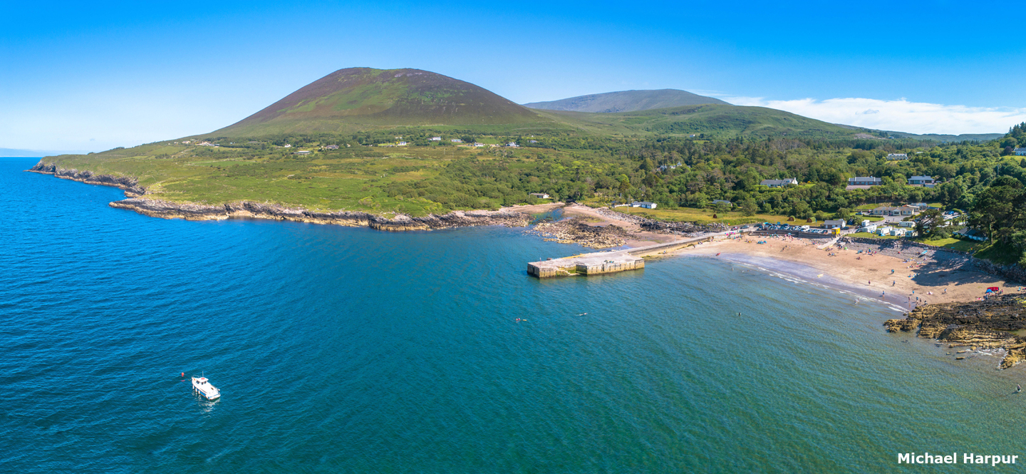
 Kells Bay as seen from its western side
Image: Michael Harpur
Kells Bay is a deep bay situated on the southern shore of Dingle Bay nearly two-thirds of the way up the Iveragh Peninsula northern shoreline, about 10 miles within Doulos Head and 5 miles from the head of the bay. It is northeastward opening coastal bight flanked by mountains to the west, east and south. At its head is a substantive pier that dries with a slipway on its east side as well as a further slipway along its extensive beach. The beach is backed by a car park and some small seasonal beach shops.
 The pier in the middle of Kells Bay
Image: Michael Harpur
Kells Bay has plenty of depth and provides good shelter in winds from southeast round through west. Kerry County Council provides four public visitors' buoys that were reportedly serviced in Spring 2022. It is also possible to anchor outside the moorings and land on the beach or by the pier.
How to get in?
 The northeast opening Kells Bay
Image: Michael Harpur
 Use Ireland’s coastal overview for Mizen Head to Loop Head for seaward approaches. The bay tends to remain hidden when following the southern shoreline from westward until it opens up around its low sheltering western headland.
 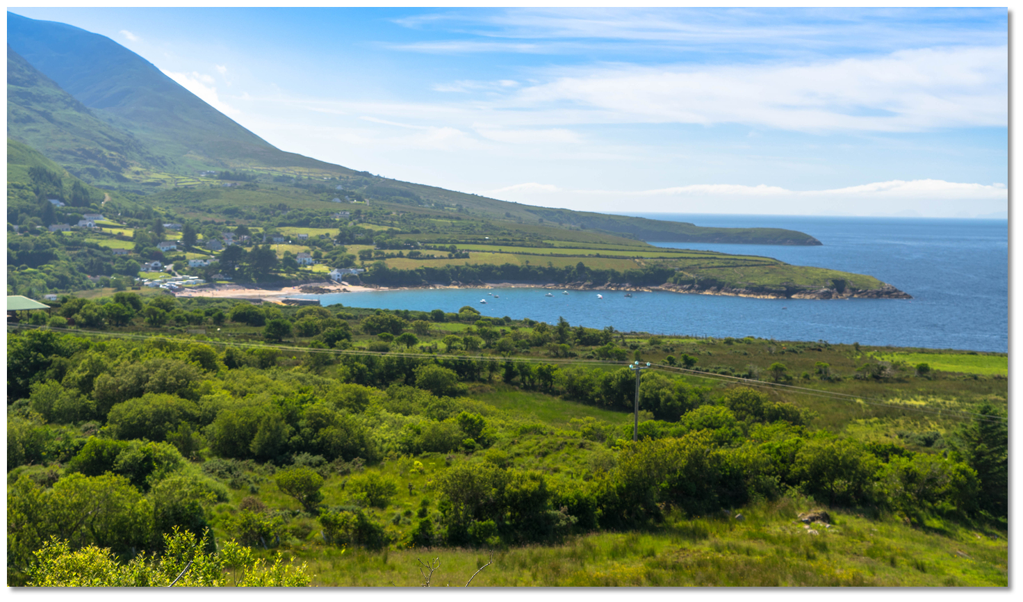 The boat moorings tucked in under the western headland of the bay
Image: Michael Harpur
 The Initial Fix is set immediately outside the ¼ of a mile entrance. Steering a central path will provide a deep path that is clear of outlying dangers.
  The visitor moorings are located off the western point
Image: Michael Harpur
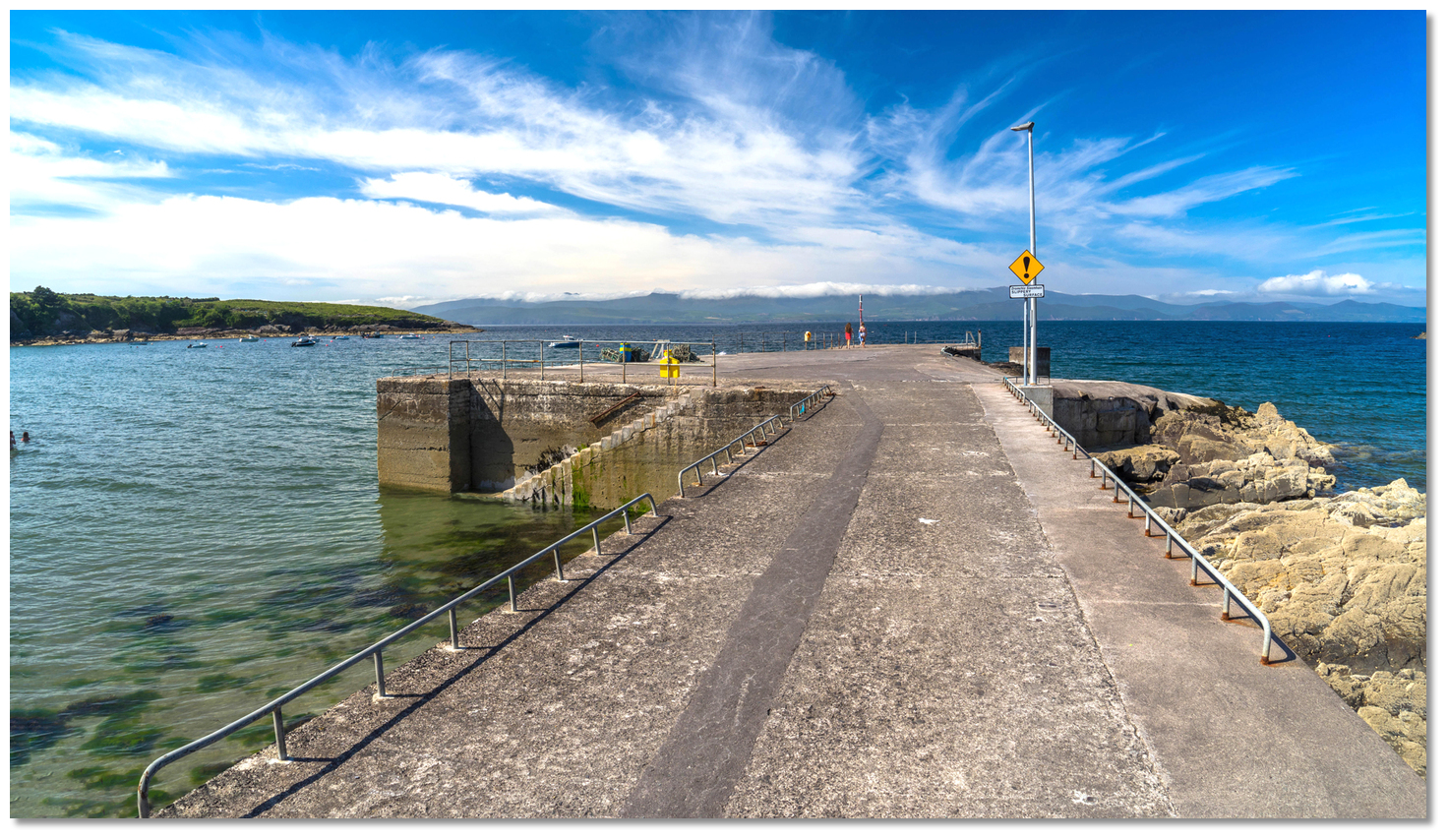
Visitors' moorings are just behind the western point, off a reef. Anchor outside the visitor and local boat moorings in 9 metres over good holding. Land at the pier which just dries at its head at LAT.  The refurbished and substantive pier in Kells Bay
Image: Michael Harpur
It may be possible to temporarily come alongside its outer face as it reportedly has 3.6 metres at high water.
Why visit here?
Kells Bay, in Irish 'Cuan na gCeall', was first recorded in 1654 as 'Cuenakeall' and the name is a direct translation from the original Irish name. The formative 'cuan' means 'bay, harbour, or recess' in Irish with 'na gCeall' most likely derived from 'na cealla', 'the churches'. So this would make it the 'bay of the churches'. The disserved family favourite of Kells Bay
Image: Michael Harpur
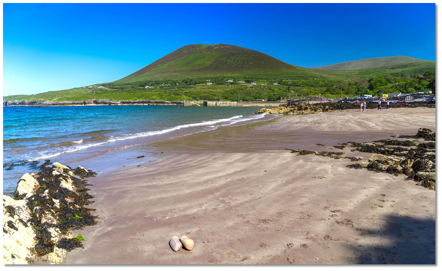
The old fishing village backing the beach would have certainly had small old churches in the past and little has changed. It remains a quiet and peaceful place that has remained undisturbed by recent developments. Its primary draw is its spectacular sheltered beach, one of Kerry's Blue Flag beaches, which makes it a favourite spot for families and holiday cottages.
 View from the root of Kells Bay pier
Image: Michael Harpur
Truly, this is a spectacular beach and a must for boats with young families or adults alike. The wide, horseshoe-shaped inlet, is perfectly framed by high mountains to the west, east and south. At its head is a glorious secluded sandy beach that is bordered by tall elegant oaks and pines, which push in on its western end, and a freshwater stream babbles over stones as it exits to the sea on the eastern end. Between these points is a sheltered stone pier from which to look out to sea. There, the occasional small pretty fishing boat and small leisure craft bob on their moorings, just offshore in the crystal-clear water. Further out in is Dingle Bay and in the far distance its northern shoreline. Kells Bay is a worthy family favourite for young or old, as a fine day can certainly be enjoyed here.
 Ferns and exotic plants at Kells Bay House and Gardens
Image: Tourism Ireland
For those looking for a contrasting rainforest experience, a 10-minute walk from the beach leads up to the Kells Bay House and Gardens which teems with ferns and exotic plants. It all began as part of Holly Mount, a small hunting estate bought in 1837 by a Tralee landlord Sir Rowland Blennerhassett. His grandson, Sir Rowland Blennerhassett MP, went on to develop the house and the subtropical gardens extend over 44 acres (18 hectares) today.
 Waterfall at Kells Bay House and Gardens
Image: Tourism Ireland
Today it contains one of the foremost collections of rare sub-tropical plants, tender trees and shrubs from the Southern Hemisphere in Europe. In Victorian times these were assembled from Australia but in more recently come from New Zealand and South America. Many of which have now become naturalised thanks to the mild and temperate Gulf stream. The gardens are a wonderful experience that also has the added benefit of a coffee shop and restaurant.
 Kells Bay is a place to relax in a placid peaceful environment
Image: Michael Harpur
From a boating point of view, this is a well-protected anchorage, that should the weather change is just 10 miles from the pontoons of Dingle Harbour. It is a place to come to relax in fine weather and enjoy some downtime in a placid place of perfect beauty.
What facilities are available?
Freshwater tap on the pier and seasonal toilets. There is a shop and restaurant near the beach during the holiday season and the house by the small car park sells ice creams. Kells Bay House and Gardens provide a coffee shop, Thai restaurant, toilets, WiFi. About 15 minutes walk along the road to Castlemaine there is Pat's filling station, incorporating a craft shop, restaurant, food store and post office. Caitin's pub is 3km distant in the opposite direction.Bus services: 279 Killarney - Kells - Cahersiveen. Two per day Mondays to Saturdays. 280 Ring of Kerry Bus.
Any security concerns?
Never an issue known to have occurred to a vessel moored off Kells Bay.With thanks to:
eOceanic ResearchAbout Kells Bay
Kells Bay, in Irish 'Cuan na gCeall', was first recorded in 1654 as 'Cuenakeall' and the name is a direct translation from the original Irish name. The formative 'cuan' means 'bay, harbour, or recess' in Irish with 'na gCeall' most likely derived from 'na cealla', 'the churches'. So this would make it the 'bay of the churches'.
The disserved family favourite of Kells BayImage: Michael Harpur
The old fishing village backing the beach would have certainly had small old churches in the past and little has changed. It remains a quiet and peaceful place that has remained undisturbed by recent developments. Its primary draw is its spectacular sheltered beach, one of Kerry's Blue Flag beaches, which makes it a favourite spot for families and holiday cottages.
View from the root of Kells Bay pierImage: Michael Harpur
Truly, this is a spectacular beach and a must for boats with young families or adults alike. The wide, horseshoe-shaped inlet, is perfectly framed by high mountains to the west, east and south. At its head is a glorious secluded sandy beach that is bordered by tall elegant oaks and pines, which push in on its western end, and a freshwater stream babbles over stones as it exits to the sea on the eastern end. Between these points is a sheltered stone pier from which to look out to sea. There, the occasional small pretty fishing boat and small leisure craft bob on their moorings, just offshore in the crystal-clear water. Further out in is Dingle Bay and in the far distance its northern shoreline. Kells Bay is a worthy family favourite for young or old, as a fine day can certainly be enjoyed here.
Ferns and exotic plants at Kells Bay House and GardensImage: Tourism Ireland
For those looking for a contrasting rainforest experience, a 10-minute walk from the beach leads up to the Kells Bay House and Gardens which teems with ferns and exotic plants. It all began as part of Holly Mount, a small hunting estate bought in 1837 by a Tralee landlord Sir Rowland Blennerhassett. His grandson, Sir Rowland Blennerhassett MP, went on to develop the house and the subtropical gardens extend over 44 acres (18 hectares) today.
Waterfall at Kells Bay House and GardensImage: Tourism Ireland
Today it contains one of the foremost collections of rare sub-tropical plants, tender trees and shrubs from the Southern Hemisphere in Europe. In Victorian times these were assembled from Australia but in more recently come from New Zealand and South America. Many of which have now become naturalised thanks to the mild and temperate Gulf stream. The gardens are a wonderful experience that also has the added benefit of a coffee shop and restaurant.
Kells Bay is a place to relax in a placid peaceful environmentImage: Michael Harpur
From a boating point of view, this is a well-protected anchorage, that should the weather change is just 10 miles from the pontoons of Dingle Harbour. It is a place to come to relax in fine weather and enjoy some downtime in a placid place of perfect beauty.
Other options in this area
Click the 'Next' and 'Previous' buttons to progress through neighbouring havens in a coastal 'clockwise' or 'anti-clockwise' sequence. Alternatively here are the ten nearest havens available in picture view:
Coastal clockwise:
Dingle Harbour - 5.7 miles NWVentry Harbour - 6.8 miles WNW
Great Blasket Island - 9.8 miles WNW
Smerwick Harbour - 9.3 miles NW
Brandon Bay - 9.1 miles N
Coastal anti-clockwise:
Cooncrome Harbour (Cuas Crom) - 4.3 miles WSWKnightstown - 5.5 miles SW
Cahersiveen - 4.1 miles SW
Portmagee - 8 miles SW
Great Skellig (Skellig Michael) - 13.7 miles SW
Navigational pictures
These additional images feature in the 'How to get in' section of our detailed view for Kells Bay.


| Detail view | Off |
| Picture view | On |
Add your review or comment:
Please log in to leave a review of this haven.
Please note eOceanic makes no guarantee of the validity of this information, we have not visited this haven and do not have first-hand experience to qualify the data. Although the contributors are vetted by peer review as practised authorities, they are in no way, whatsoever, responsible for the accuracy of their contributions. It is essential that you thoroughly check the accuracy and suitability for your vessel of any waypoints offered in any context plus the precision of your GPS. Any data provided on this page is entirely used at your own risk and you must read our legal page if you view data on this site. Free to use sea charts courtesy of Navionics.