
The Saltee Islands are two small landmasses off the southeast corner of Ireland, approximately halfway between Hook Head and Carnsore Point. The southernmost Great Saltee Island is the larger of the pair, with Gilert Bay being the smaller of two adjacent anchorages available off the island’s southern side.
Gilert Bay is an exposed anchorage that is only suitable for a day trip after a prolonged settled spell. Despite appearing as though a vessel can tuck snugly into the bay, there is in fact little protection if there is any sea swell. The Saltee Islands require careful navigation, owing to the numerous outlying rocks and strong currents. They are, however, very workable in settled, clear conditions and highly enjoyable.


Keyfacts for Gilert Bay


Last modified
May 23rd 2022 Summary
An exposed location with careful navigation required for access.Facilities
None listedNature


Considerations
Position and approaches

Expand to new tab or fullscreen
Haven position
 52° 6.905' N, 006° 36.694' W
The waypoint is in the centre of the bay, where you may drop the anchor into sand at a depth of 3 metres at low water.
What is the initial fix?
The following Gilert Bay initial fix will set up a final approach:
 52° 6.700' N, 006° 36.603' W


What are the key points of the approach?
Offshore details are available in southeastern Ireland’s coastal overview for Rosslare Harbour to Cork Harbour  . The Kilmore Quay
  entry provides approach directions for this haven.
. The Kilmore Quay entry provides approach directions for this haven.Not what you need?
Click the 'Next' and 'Previous' buttons to progress through neighbouring havens in a coastal 'clockwise' or 'anti-clockwise' sequence. Below are the ten nearest havens to Gilert Bay for your convenience.
Ten nearest havens by straight line charted distance and bearing:
- Georgina’s Bay - 0.2 nautical miles WSW
- Great Saltee (landing beach) - 0.4 nautical miles N
- Little Saltee (west side) - 1.5 nautical miles NNE
- Little Saltee (east side) - 1.7 nautical miles NE
- Little Saltee (landing beach) - 1.8 nautical miles NNE
- Kilmore Quay - 3.5 nautical miles NNE
- Baginbun Bay - 8.7 nautical miles WNW
- Bannow Bay - 8.8 nautical miles NW
- Fethard On Sea - 9.1 nautical miles WNW
- Slade - 11 nautical miles W
These havens are ordered by straight line charted distance and bearing, and can be reordered by compass direction or coastal sequence:
- Georgina’s Bay - 0.2 miles WSW
- Great Saltee (landing beach) - 0.4 miles N
- Little Saltee (west side) - 1.5 miles NNE
- Little Saltee (east side) - 1.7 miles NE
- Little Saltee (landing beach) - 1.8 miles NNE
- Kilmore Quay - 3.5 miles NNE
- Baginbun Bay - 8.7 miles WNW
- Bannow Bay - 8.8 miles NW
- Fethard On Sea - 9.1 miles WNW
- Slade - 11 miles W


What's the story here?
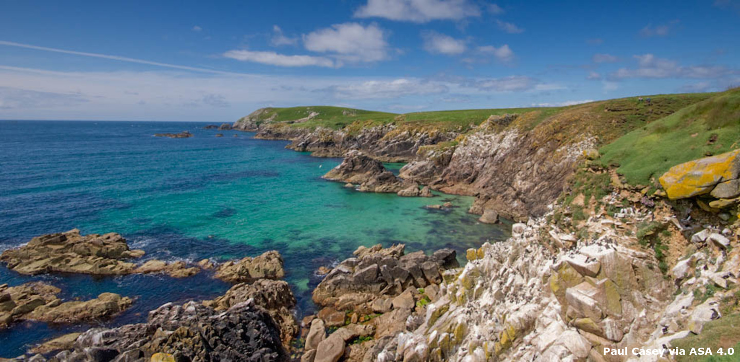
 Gilert Bay as seen from close south
Image: Burke Corbett
The Saltee Islands of Great and Little Saltee are situated approximately 4 miles off the coast of Kilmore Quay, County Wexford. They are privately owned but have been largely unoccupied since the early 20th century. Great Saltee Island lies about 3¼ miles from Kilmore Quay, has an area of about 87ha (215 acres) and is wedge-shaped. The island ascends from a low shore on its northern mainland side to 20- to 30-metre-high cliffs on its southeastern side. The southern summit rises to an altitude of 58 metres, its highest point.
The Saltees are a haven for an impressive array of seabirds, from gannets and gulls to puffins and Manx shearwaters. The islands also lie on an important migratory route and are a popular stopping-off place for spring and autumn migrants. In addition to its birdlife, Great Saltee has a breeding population of grey seals, one of the very few in eastern Ireland. Up to 120 are present in autumn and as many as 20 pups are born here annually. All of this combines to make it a Special Area of Conservation and a very popular destination for day-trippers and birdwatchers alike.
Gilert Bay is the smaller of the two bays tucked in to the south side of the island. It offers an alternative to the larger Georgina’s Bay.
How to get in?
 Gilert Bay as seen from the west end of Great Saltee Island
Photo: Public Domain
 Offshore details are available in southeastern Ireland’s coastal overview for Rosslare Harbour to Cork Harbour and the adjacent Georgina’s Bay entry provides approach directions for the south side of Great Saltee Island. Those planning to cruise this area should study the ‘Additional notes for the Saltee Islands’ set out in the Rosslare Harbour to Cork Harbour . A sharp lookout should always be kept for lobster pots in and around the Kilmore Quay area.
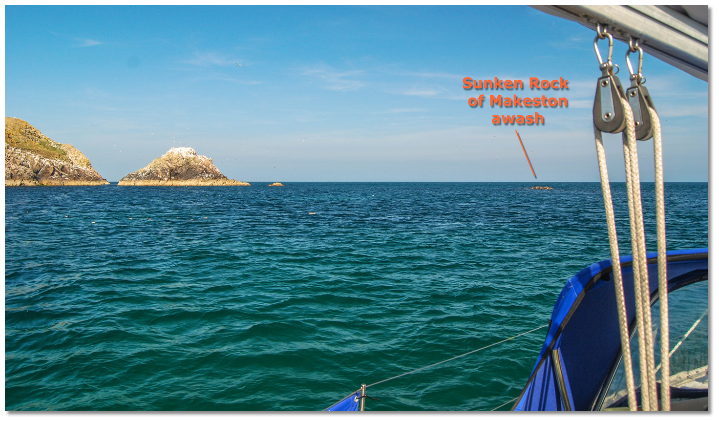 Sunken Rock of Makeston awash 200 metres to the southwest of Makeston Rock
Image: Burke Corbett
 From the initial fix or in clear water due south of the described anchoring position, approach the anchorage on a 000° track, maintaining a sharp lookout to starboard for the ‘Sunken Rock of Makeston’. This is the key rock to locate upon entry as it marks the eastern side of Gilert Bay. It lies 200 metres to the southwest, bearing from 210° T, of Makeston Rock.
  The pinnacle rocks that separate Gilert Bay from Georgina’s Bay
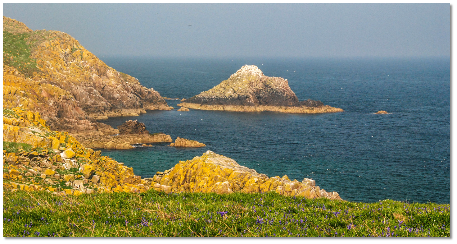
Image: Burke Corbett
Once this has been located, keep the visible pinnacle rocks that separate Gilert Bay from Georgina’s Bay to port and enter the small bay.
 Gilert Bay as seen from the west
Image: Michael Harpur
Once securely within the bay, anchor in sand according to draught and conditions. The head of the bay, depending on the previous month’s heavy weather conditions, may offer either a sand or shingle beach to land upon at low water. Why visit here?
This is another lovely, secluded place on the back of Great Saltee Island, where a vessel can enjoy a peaceful repose or land a dinghy and let the family loose to swim and explore. Visitors will most likely have this hidden bay to themselves, along with its wonderful wealth of wildlife. Guillemots over Gillert's Bay
Image: Michael Harpur
It also offers an alternative to neighbouring Georgina’s Bay, which may get busy on a settled sunny sailing season day. Like the larger Georgina’s Bay, Gilert Bay is an excellent place to drop the hook, sit back in the cockpit and enjoy the wealth of the Saltee’s hallmark birdlife.
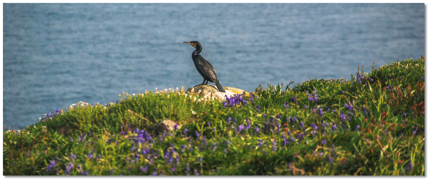 A shag surveying Gilert Bay
Image: Michael Harpur
Late season visitors, in and about September time, will find this bay hosts up to half a dozen seal pups upon the small beach at the head of cut. They prefer Gilert Bay as the older seals tend to stay on a shelf behind Makeston Rock.
 A black-backed gull flying over the bay
Image: John Finn
The single point to note about the island’s southern anchorages is that the cliffs are steep here. Although it is possible to alight upon their enclosed beaches at low water, it is not possible to get up to and explore the island from either of these anchorages. The main landing beach, on the north side of the island, should be used for those who wish to come ashore and explore.
What facilities are available?
There are no facilities on the Saltee Islands. Immediately ashore, Kilmore Quay has all facilities.Any security concerns?
Security issues are unheard of on the Saltee Islands. In fact, if anything the reverse is more likely to be encountered. Local boatmen are very welcoming and you can take it that they will by good nature keep an eye on the welfare of your vessel, should she drag whilst you are ashore, and be ready to assist you.With thanks to:
Burke Corbett, Gusserane, New Ross, Co. Wexford. Photography with thanks to Burke Corbett, Kevin Higgins, John Finn and Michael Harpur.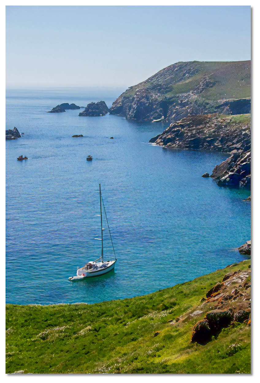
Gilert’s Bay, Great Saltee Island, County Wexford, Ireland
Image: eOceanic thanks Kevin Higgins via CC-BY-SA 2.0
The Saltee Islands that can be seen from Gilert Bay
About Gilert Bay
This is another lovely, secluded place on the back of Great Saltee Island, where a vessel can enjoy a peaceful repose or land a dinghy and let the family loose to swim and explore. Visitors will most likely have this hidden bay to themselves, along with its wonderful wealth of wildlife.
Guillemots over Gillert's BayImage: Michael Harpur
It also offers an alternative to neighbouring Georgina’s Bay, which may get busy on a settled sunny sailing season day. Like the larger Georgina’s Bay, Gilert Bay is an excellent place to drop the hook, sit back in the cockpit and enjoy the wealth of the Saltee’s hallmark birdlife.
A shag surveying Gilert BayImage: Michael Harpur
Late season visitors, in and about September time, will find this bay hosts up to half a dozen seal pups upon the small beach at the head of cut. They prefer Gilert Bay as the older seals tend to stay on a shelf behind Makeston Rock.
A black-backed gull flying over the bayImage: John Finn
The single point to note about the island’s southern anchorages is that the cliffs are steep here. Although it is possible to alight upon their enclosed beaches at low water, it is not possible to get up to and explore the island from either of these anchorages. The main landing beach, on the north side of the island, should be used for those who wish to come ashore and explore.
Other options in this area
Click the 'Next' and 'Previous' buttons to progress through neighbouring havens in a coastal 'clockwise' or 'anti-clockwise' sequence. Alternatively here are the ten nearest havens available in picture view:
Coastal clockwise:
Georgina’s Bay - 0.1 miles WSWBannow Bay - 5.4 miles NW
Fethard On Sea - 5.6 miles WNW
Baginbun Bay - 5.4 miles WNW
Slade - 6.8 miles W
Coastal anti-clockwise:
Great Saltee (landing beach) - 0.3 miles NKilmore Quay - 2.1 miles NNE
Little Saltee (west side) - 0.9 miles NNE
Little Saltee (east side) - 1 miles NE
Little Saltee (landing beach) - 1.1 miles NNE
Navigational pictures
These additional images feature in the 'How to get in' section of our detailed view for Gilert Bay.


| Detail view | Off |
| Picture view | On |
The Saltee Islands that can be seen from Gilert Bay
Add your review or comment:
Please log in to leave a review of this haven.
Please note eOceanic makes no guarantee of the validity of this information, we have not visited this haven and do not have first-hand experience to qualify the data. Although the contributors are vetted by peer review as practised authorities, they are in no way, whatsoever, responsible for the accuracy of their contributions. It is essential that you thoroughly check the accuracy and suitability for your vessel of any waypoints offered in any context plus the precision of your GPS. Any data provided on this page is entirely used at your own risk and you must read our legal page if you view data on this site. Free to use sea charts courtesy of Navionics.