
Portmagee is a pleasant harbour that affords good protection from all wind and sea conditions. Access requires normal navigation with due diligence. Although there are no specific difficulties, it can be boisterous when entering the channel, but once inside the channel it settles and contracts and has fringing and reefs that require attentive navigation to make way to the quay.


Keyfacts for Portmagee


Nature


Considerations


Protected sectors


Summary* Restrictions apply
A good location with attentive navigation required for access.Nature
Considerations
Position and approaches

Haven position
 51° 53.200' N, 010° 22.020' W
The pierhead at Portmagee village near the bridge.
What is the initial fix?
 51° 52.730' N, 010° 25.000' W


What are the key points of the approach?
 .
.- Approach between Bray Head and the islands and rocks fronting the coast between Doon Point and Reencaragh Point.
- Best water will be found between a channel and the north shore there in.
Not what you need?
- Knightstown - 3.9 nautical miles NE
- Ballinskellig Bay - 5.9 nautical miles SE
- Cooncrome Harbour (Cuas Crom) - 6.1 nautical miles NE
- Cahersiveen - 6.2 nautical miles NE
- Great Skellig (Skellig Michael) - 9.3 nautical miles SW
- Darrynane Harbour - 11.1 nautical miles SE
- Kells Bay - 12.8 nautical miles NE
- West Cove - 13.6 nautical miles ESE
- Ventry Harbour - 13.8 nautical miles N
- Great Blasket Island - 14.3 nautical miles NNW
- Knightstown - 3.9 miles NE
- Ballinskellig Bay - 5.9 miles SE
- Cooncrome Harbour (Cuas Crom) - 6.1 miles NE
- Cahersiveen - 6.2 miles NE
- Great Skellig (Skellig Michael) - 9.3 miles SW
- Darrynane Harbour - 11.1 miles SE
- Kells Bay - 12.8 miles NE
- West Cove - 13.6 miles ESE
- Ventry Harbour - 13.8 miles N
- Great Blasket Island - 14.3 miles NNW

Chart

What's the story here?
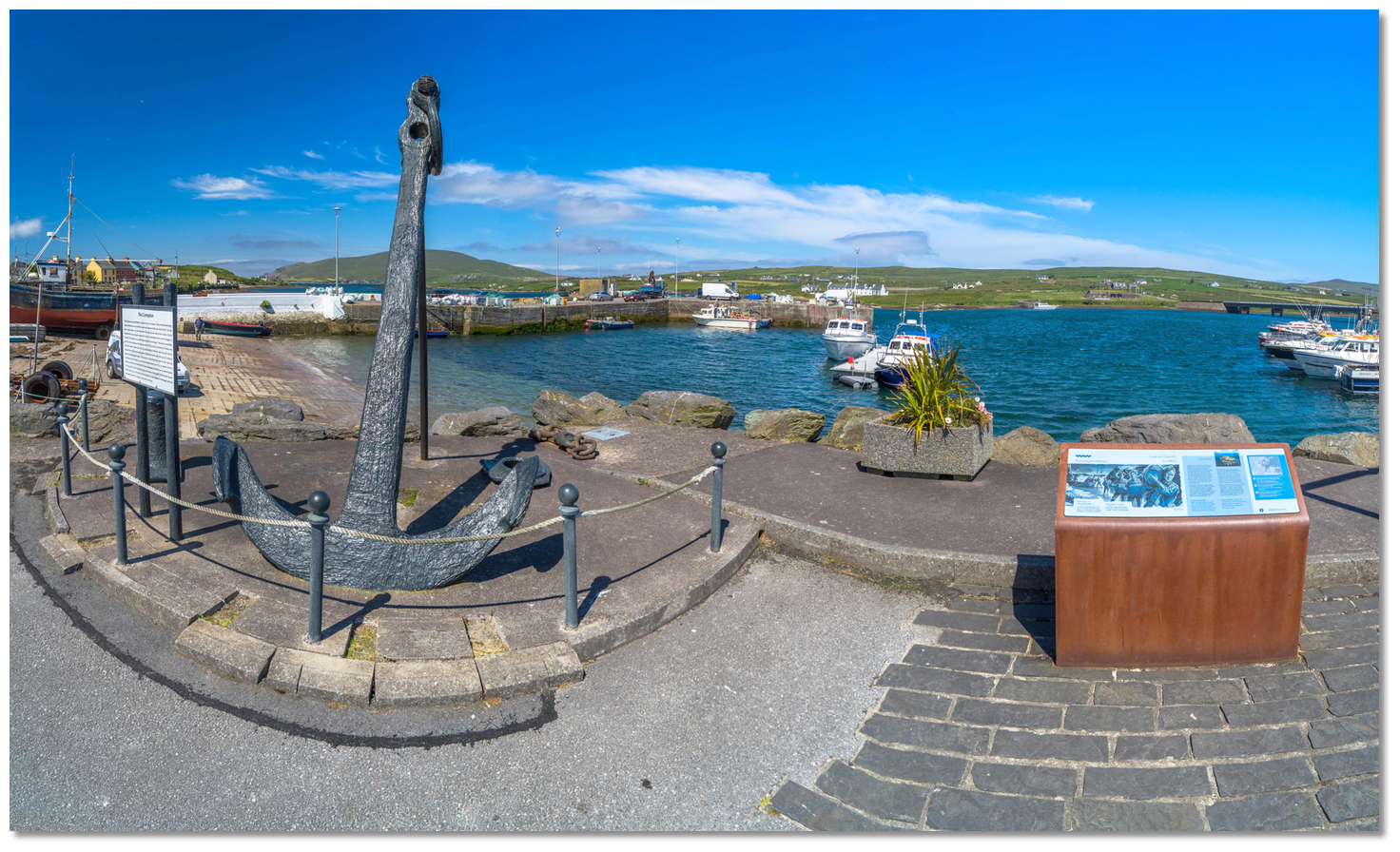
 Portmagee village and pier
Image: Kevin McNamee via CC BY SA 2.0
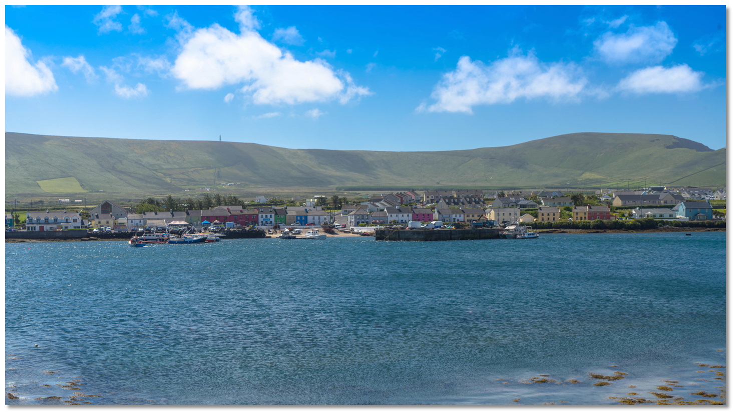
Portmagee is a small village and fishing harbour situated at the west end of Portmagee Channel. The channel opens immediately to the south of Bray Head and at the seaward end of the strait that separates Valentia Island from the mainland. The anchoring area is 2½ miles east of Bray Head in Portmagee Sound, between Valentia Island and the mainland where there is a pier.
 Portmagee village as seen from the pier
Image: Michael Harpur
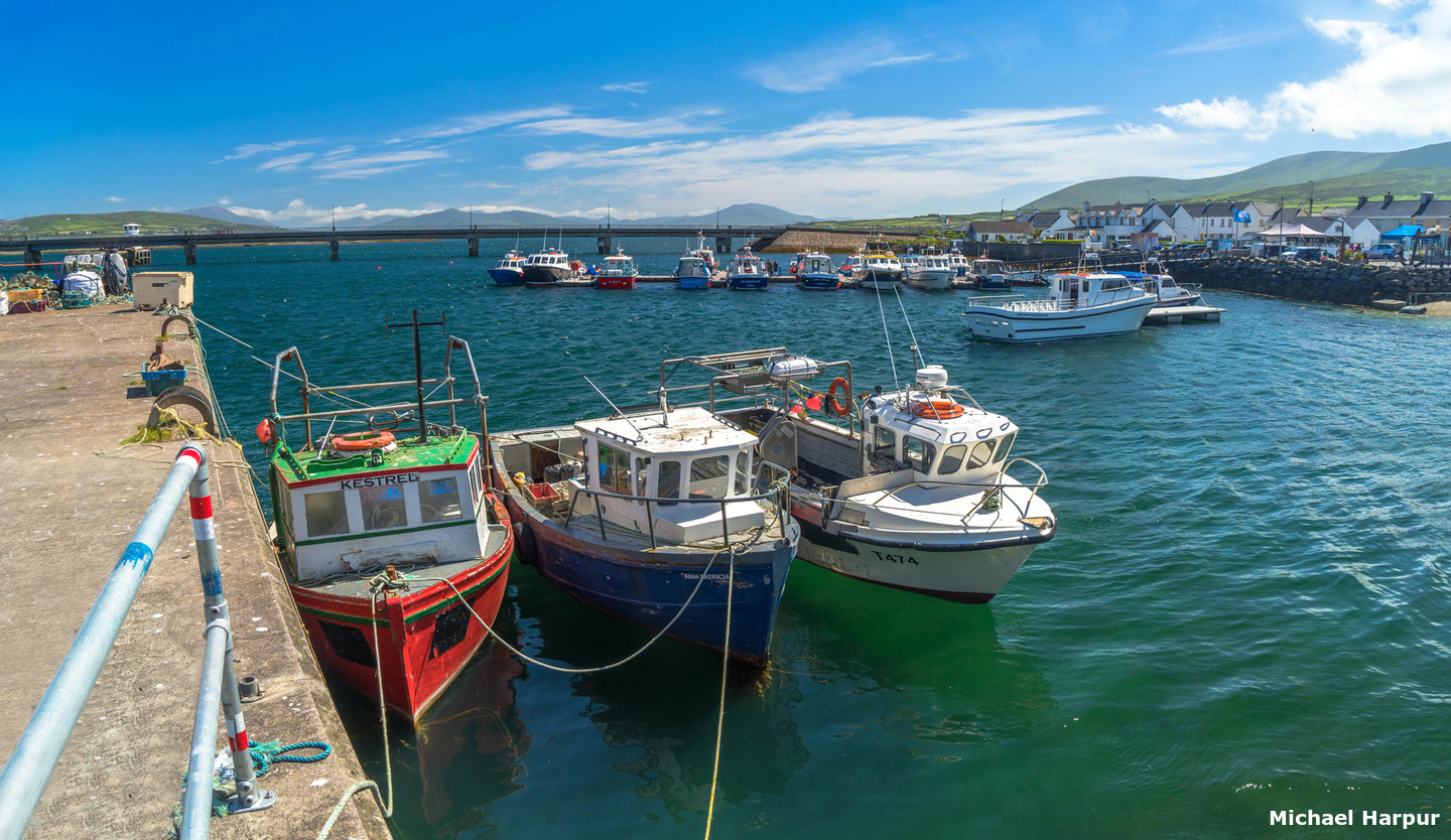
Portmagee offers a secure anchorage off the pier in 5 metres, opposite Skelling Heritage Centre. The pier is best avoided as it is mainly used by fishing vessels and it is subject to strong tides. There is a pontoon that has six finger pontoons, close east of the pier. It has water and power and is predominantly used by sea angling boats and the Skellig passenger boats. But the berths outside of the T-head are available for visiting yachts and it has 2 meters LAT. Please contact Ger Kennedy at 087-2390010.
 Fishing boat on Portmagee's extensive slipway
Image: Michael Harpur
The pontoon is usually busy with tourists boarding tour boats plying their trade to Great Skellig from 9 am - 7 pm. This is something to note about Portmagee in general, although remote, it can be a busy spot during the summer with Tour boats flying up and down creating an uncomfortable anchorage during the day.
How to get in?
 Bray Head makes for an unmistakable seamark
Image: Michael Harpur
 Use Ireland’s coastal overview for Mizen Head to Loop Head for seaward approaches. Valentia Island, on the southern side of the entrance of Dingle Bay, terminates to the southwestward in Bray Head, a bold precipitous headland with above-water laying close southwestward of the head.
  The entrance to Portmagee Sound as seen from seaward
Image: Graham Rabbits
The southeastern side of the island forms the northwestern side of the Portmagee Channel with Portmagee entered from westward. This is between Bray Head and the islands and rocks fronting the coast between Doon Point and Reencaragh Point, about a ½ mile northward. The coastal area offshore of Doon Point is steep-to with no off-lying dangers.
_to_bray_head.jpg) Gull Point (⅓ of a mile south of Doon Point behind) to Bray Head
Gull Point (⅓ of a mile south of Doon Point behind) to Bray HeadImage: Still ePsiLoN via CC BY 4.0
 From the initial fix Bray Head, the southwest extremity of the island, is bold and precipitous.
 Steer into the middle of the entrance surrounded by high cliffs. Expect a rough sea in this area as the waves and wind interact with the cliff faces. This is particularly in strong south-westerlies and with the wind inclining off either shore, violent gusts occur from the surrounding high lands.
 The Portmagee Channel as seen from Bray Head
 Image: Elkringo via CC BY-SA 3.0
Although formidable-looking it is nevertheless, it is a ¼ of a mile wide and free of obstacles with its rocks and islets all showing above high water. This said, make note of Long Island’s off-lying Bull Rock, 7 meters high, and Horse Island’s off-lying Deaf Rocks, 4 & 5 meters high, all of which show.
.jpg) Horse Island and the off-lying Deaf Rocks
Horse Island and the off-lying Deaf Rocks with Long Island and the Bull Rock (behind)
Image: Mat Tuck CC BY SA 2.00
A ½ mile northward of Reencaragh Point, 21 metres high, the channel narrows into Portmagee Sound where the fairway lies off the northern shore - generally expect the deeper water to be on the north side of the channel, except at Quay Brack which has the outlying Anchor Rock (not named on the chart).
 The Scughaphort Reef
Image: Anthony Rue via CC BY SA 2.00
Pass into the narrows between Reencaheragh Point and Scughaphort Reef tending to the north side of the channel and taking care to keep off the southern shore to the east of Reencaheragh Point. It has rocky ledges that fringe the mainland shoreline that should be given a berth of about 100 metres in order to avoid an awash rock that extends beyond the reef eastward of Reencaragh Point. On the opposite side Anchor Rock, which uncovers at low water, lies 100 metres off Quay Brack. There is ample space in the fairway but oncoming traffic should also be expected at each turn.
_and_valentia_island.jpg) Two boats preparing to pass Loughan Islet (left) and Valentia Island
Two boats preparing to pass Loughan Islet (left) and Valentia IslandImage: Michael Harpur
With Quay Brack abeam to port, continue east-northeast about 60 metres off of the island side of the channel. Pass midchannel between Valentia Island and Loughan Islet, 4 meters and surrounded by foul ground, which lies off the mainland shore. When Loughan Islet comes abeam the pier and village will be visible and it is safe to steer for the head of the pier.
 Portmagee Harbour
Image: Michael Harpur
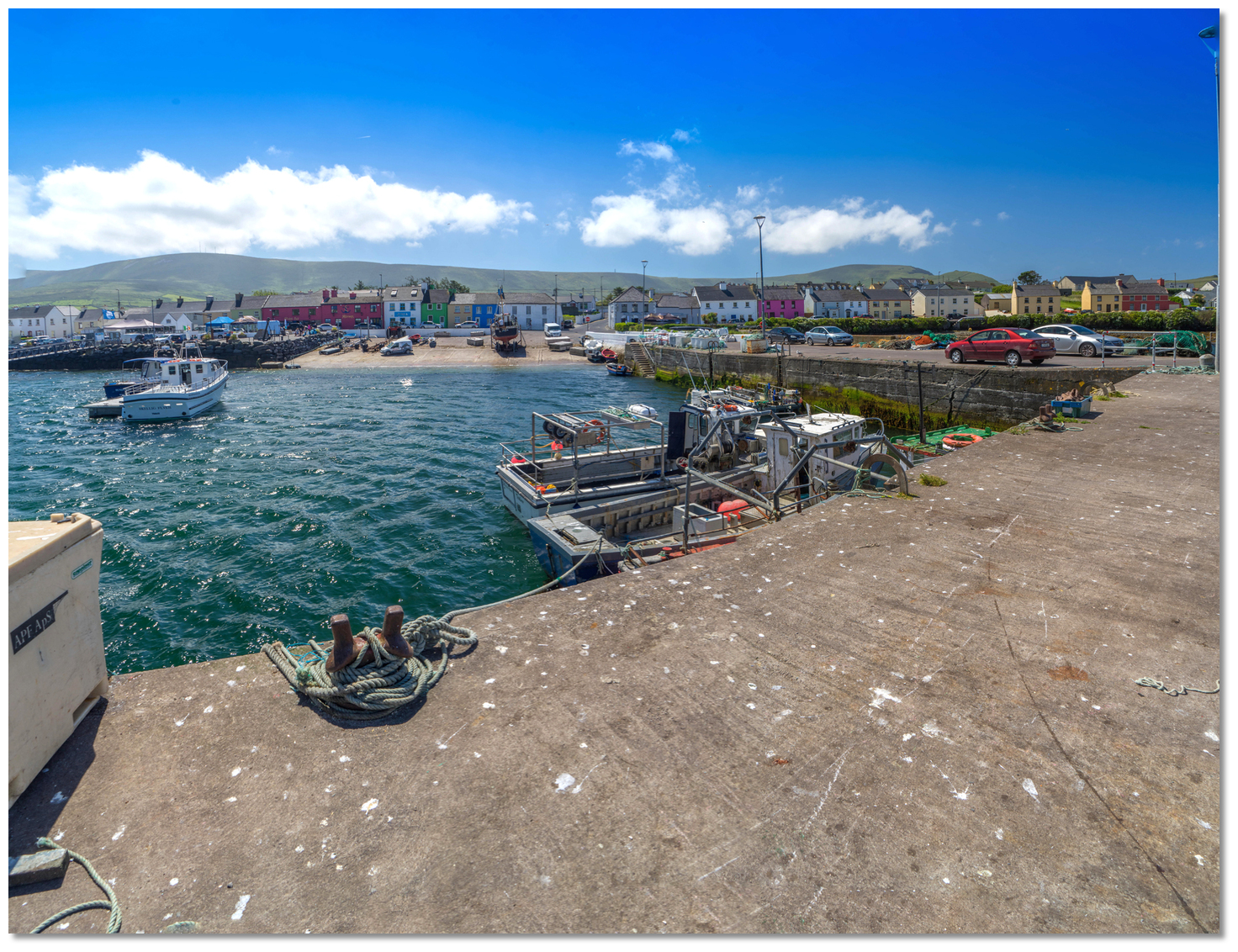
Avoid the well-charted underwater cable that connects to the island just west of the pier. A good anchorage is available off the pier with 5 metres of depth about 100 metres off the pierhead and clear of the underwater cable. The area is subject to strong tides but equally good holding in sand and mud. 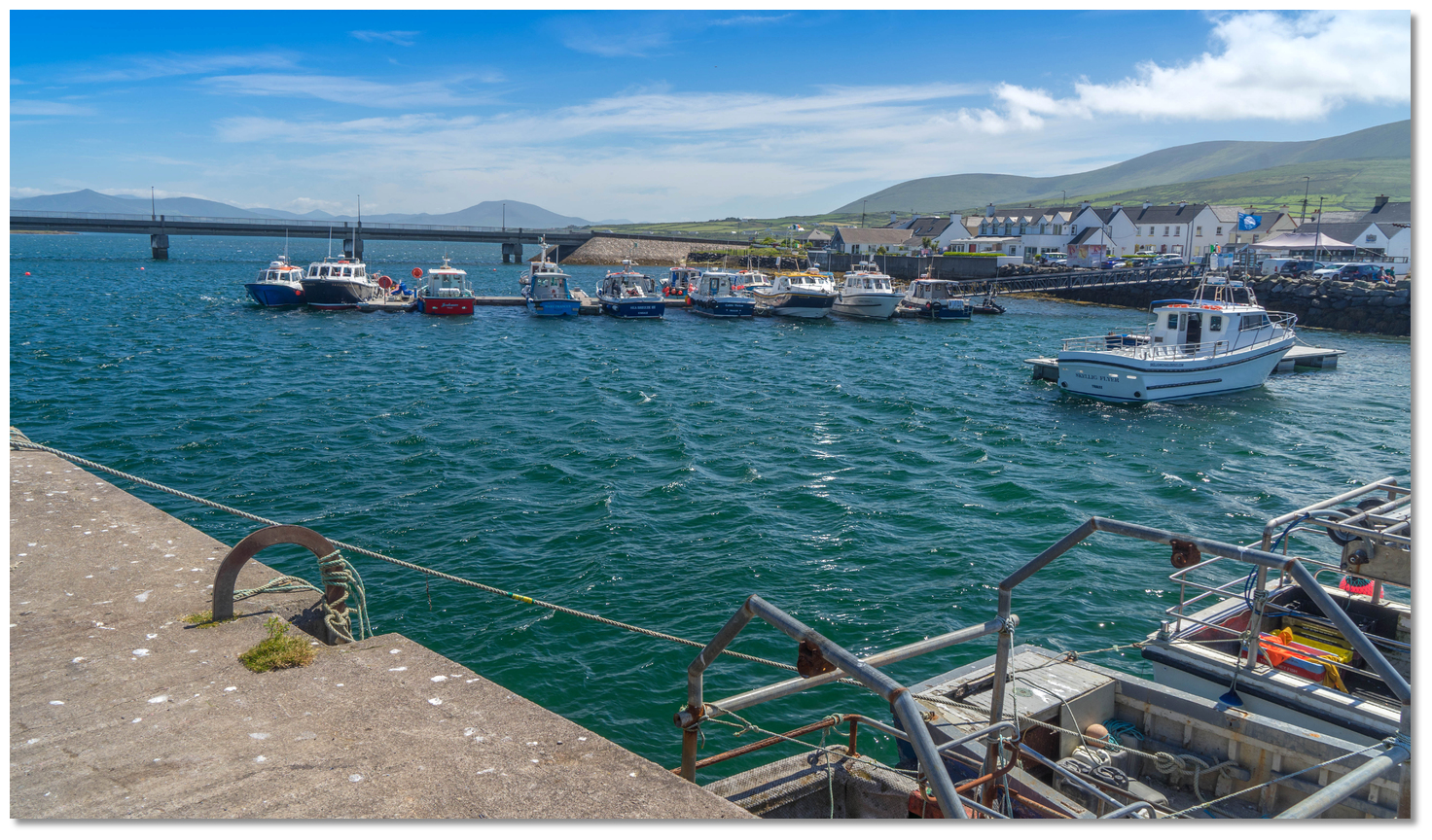 Pontoon close east of the quay
Image: Michael Harpur
Anchoring off the north shore will avoid the worst of the current, the tour boat wash and be less of an obstruction to manoeuvring fishing vessels. Avoid the section close west of the pier where an underwater cable runs to Carriglea Point. Alternatively, come alongside the pontoon if a berth is available to have walk ashore access to the town.
 Portmagee Pontoon
Image: Michael Harpur
The pierhead's north and east faces have deep water at all states of the tide but are used by fishing vessels and the Skellig Michael launches. It may be possible to come alongside an unoccupied part of the pier for a short period if it does not impede normal operations but a vessel should not be left unattended here.
 The 100-metre-long Maurice O'Neill Memorial Bridge
Image: Michael Harpur
The channel provides an alternate pass to and from Valentia Harbour which is only 4 miles away along the Portmagee Channel. But, for vessels carrying any air draught, this is obstructed by the bridge above the harbour. The original eleven-metre wide opening span has not opened since 2004 and there are no plans to make it operational.
 Portmagee Sound between Valentia Island and the mainland
Image: Michael Harpur
But low air draught vessels that can pass under the bridge can pass freely using this channel. It has a high water depth of 4.6 metres and a least sounding of 1.5 metres LAT at the bend south of Reenarea Point a ⅓ of a mile east by northeastward of the bridge. After this, it is a wide expanse with deepwater that is clear of dangers.
 Portmagee Sound perches beyond the bridge marking the path to Reenarea Point
Image: Michael Harpur
The most complex part is between the perches which mark the first ⅓ mile from the bridge to the bend. Seek local knowledge for this first part as the channel is obstructed by rocks and the navigation is challenging and perhaps easier at LW when the dangers show. There is a 2.6-metre patch between Reenarea Point and the bridge where a deeper-draught boat, having used a low tide to get under the bridge, could await the rise to provide sufficient draught to proceed over the shallow ridge.
Why visit here?
Portmagee is called 'An Caladh' in Irish, meaning 'the ferry', and is often referred to as such by locals. This is because it was once the site of a ferry service that crossed between the village and Valentia Island. Originally called 'An Caladh', 'the ferry', as it once was the site of a ferry
service to Valentia Island
Image: A Ryan via CC BY SA 2.00
The harbour acquired the English name 'Portmagee' in the 18th-century after Captain Theobald Magee build up an extensive commercial shipping business here. Theobald Magee was an officer in King James' army who fought to reclaim the English Crown after the 1688 'Glorious Revolution'. After James' conclusive defeat at the Battle of the Boyne, Magee retired and became the commander of a merchant ship here. Making this his home port he set up trade between this France and Portugal and it was during this time that it became known as Port of Magee.
 Plaque commemorating Captain Theobald Magee on the quay
Image: Michael Harpur
Whilst appearing to be an honest businessman and sea captain, Magee was was truly an opportunistic smuggler. Owing to the difficulty of policing the intricately jagged southwest coastline and the excessive tax markups that could be turned directly into profit, Magee built a steady and lucrative trade in contraband. These were products such as spirits, textiles, brandy, tea and tobacco from which massive profits could be derived. These allowed him to accumulate large amounts of properties in counties Kerry and Cork.
 Portmagee's Smugglers Inn is a favourite for boaters
 Image: Michael Harpur
He married Bridget Morgell, the widow of a rich Dingle merchant and daughter of the then MP for County Kerry, Thomas Crosby. The couple had five children, three boys and two girls. But being so closely related to a renowned and prosperous smuggler began to increasingly place Crosbie in a difficult position. In 1724 he finally resolved this issue by having Magee exiled to Lisbon. He would die in a convent there three years later but his wife Bridget did not mourn his death for long and carried on the family's profitable business of smuggling.
 Portmagee is southwest Kerry’s main fishing centre
Image: Michael Harpur
Today, Portmagee is a quiet village and southwest Kerry’s main fishing centre. Access to Valentia Island is catered for by the 100-metre-long Maurice O'Neill Memorial Bridge that was built adjacent to the village in 1970. Portmagee's modest single street makes the most of itself by being a rainbow of colourful houses. Captain Magee is remembered on Wednesday afternoons in July and August when he walks the streets and quays complete with cutlasses and pistols. Visitors can join him aboard his ship, the 'White Swan', to hear tales of his pirate life and even learn a sea shanty or two.
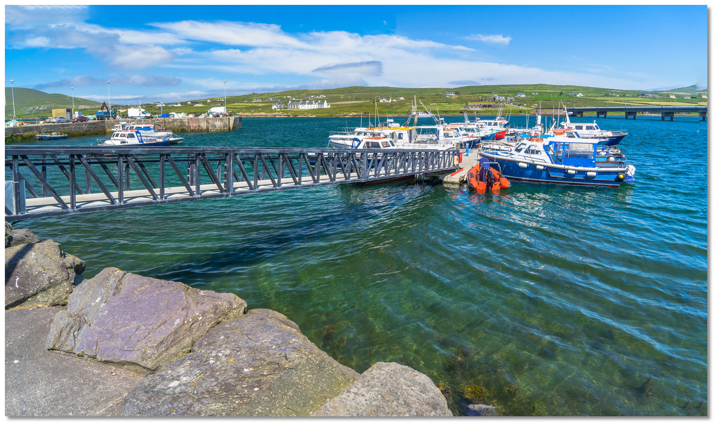 Portmagee Harbour now has a walk ashore pontoon visitor berths
 Image: Michael Harpur
The village receives a fair share of tourists on account of being the main departure point for boat trips to the Skellig Islands
 . It is the ideal point to depart for the islands so that all the crew can land ashore. Alternatively, it is possible to simply visit the dedicated 'Skellig Experience' by venturing across the bridge to Valentia Island and taking a short stroll up the road. The centre gives some fascinating background on seabirds and other marine life, lighthouses and early monastic life, and it has an impressive short film about Skellig Michael.
 Portmagee pontoon and pier as seen from the anchorage
Image: Tourism Ireland
From a boating point of view, once inside the doglegged entrance, the harbour provides excellent shelter adjacent to and very attractive harbour village. There might be some minor disturbance at anchor from tour boats and fishing vessels passing in the main channel. But this is more than made up for by the great pubs and even better seafood that these activities engender.
What facilities are available?
Freshwater is laid on at the pier and public toilets nearby. Limited quantities of provisions can be obtained from this small remote fishing village. There is a bottle and can bank with limited rubbish disposal by the bridge. There are ample pubs and good restaurants in the vicinity. The Moorings, a small hotel, offers by arrangments showers when rooms change occupancy in the mornings. The Fishermen's Bar does traditional Irish meals and is popular with locals. A launderette is available at Portmagee Community Centre. Knightstown for more, via tender.Halfway along the Portmagee Channel, there is an excellent boatyard called Murphy Marine Services which has a 20-tonne boat lift.
Any security concerns?
Never an issue known to have occurred in Portmagee.With thanks to:
Burke Corbett, Gusserane, New Ross, Co. Wexford. Updates with thanks to Mike Medcalf and Joseph Kiernan.An aerial view Portmagee and its surrounds


Add your review or comment:
Mike Medcalf wrote this review on Aug 4th 2014:
pontoon berths now available in the harbour - moorings have been removed
Average Rating: UnratedJoseph Kiernan wrote this review on Jan 11th 2019:
Very busy spot during the summer with Skelling Tour boats flying up and down creating an uncomfortable anchorage during the day. Limited depth at pontoon with tourists boarding tour boats from 9am-7pm 2 meters on outermost berth at LW.
Average Rating:

Michael Harpur wrote this review on Apr 3rd 2019:
Thank you Mike and Joseph,
I have added your insights to the main body.
Please log in to leave a review of this haven.
Please note eOceanic makes no guarantee of the validity of this information, we have not visited this haven and do not have first-hand experience to qualify the data. Although the contributors are vetted by peer review as practised authorities, they are in no way, whatsoever, responsible for the accuracy of their contributions. It is essential that you thoroughly check the accuracy and suitability for your vessel of any waypoints offered in any context plus the precision of your GPS. Any data provided on this page is entirely used at your own risk and you must read our legal page if you view data on this site. Free to use sea charts courtesy of Navionics.