
The bay provides very good shelter and holding in winds from the south through west to northeast but it is entirely open to east and south-easterly winds. Straightforward access is provided by the bay's near mile-wide entrance that is free of obstructions but a daylight entrance is recommended for strangers as there are no supporting lights.


Keyfacts for Ventry Harbour
Facilities


Nature


Considerations

Protected sectors

Approaches

Shelter
Last modified
April 10th 2022 Summary
A good location with straightforward access.Facilities
Nature
Considerations
Position and approaches

Expand to new tab or fullscreen
Haven position
 52° 6.955' N, 010° 21.890' W
This is the pierhead to the west of Pointanskoh.
What is the initial fix?
The following Ventry Bay Initial Fix will set up a final approach:
 52° 6.525' N, 010° 20.038' W


What are the key points of the approach?
Offshore details are available in southwestern Ireland’s Coastal Overview for Mizen Head to Loop Head  .
.
. - The entrance and its approaches between Parkmore Point and Paddock Point is deep wide and clear of dangers.
- Steer a southwest-to-centre to up the entrance to clear a sunken ledge off the northeast shore ( starboard side) which sometime breaks.
Not what you need?
Click the 'Next' and 'Previous' buttons to progress through neighbouring havens in a coastal 'clockwise' or 'anti-clockwise' sequence. Below are the ten nearest havens to Ventry Harbour for your convenience.
Ten nearest havens by straight line charted distance and bearing:
- Dingle Harbour - 3.5 nautical miles ENE
- Smerwick Harbour - 4.9 nautical miles NNW
- Great Blasket Island - 5.4 nautical miles W
- Cooncrome Harbour (Cuas Crom) - 9.7 nautical miles SSE
- Kells Bay - 11 nautical miles ESE
- Cahersiveen - 11.2 nautical miles SSE
- Knightstown - 11.8 nautical miles SSE
- Brandon Bay - 11.9 nautical miles NE
- Portmagee - 13.8 nautical miles S
- Castlegregory - 16 nautical miles NE
These havens are ordered by straight line charted distance and bearing, and can be reordered by compass direction or coastal sequence:
- Dingle Harbour - 3.5 miles ENE
- Smerwick Harbour - 4.9 miles NNW
- Great Blasket Island - 5.4 miles W
- Cooncrome Harbour (Cuas Crom) - 9.7 miles SSE
- Kells Bay - 11 miles ESE
- Cahersiveen - 11.2 miles SSE
- Knightstown - 11.8 miles SSE
- Brandon Bay - 11.9 miles NE
- Portmagee - 13.8 miles S
- Castlegregory - 16 miles NE

Chart

What's the story here?
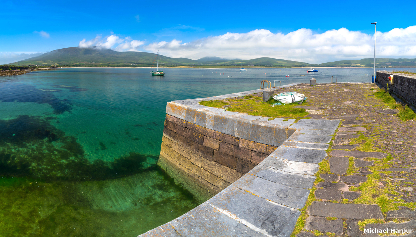
 Cuan in the southwest corner of Ventry that provides the best protection
Image: Michael Harpur
Situated on the north side of Dingle Bay, Ventry Harbour is located 4 miles to the east of Slea Head. It is a large horseshoe-shaped bay, about 1 mile wide and 1½ miles deep that opens to the southeast. Entered between Parkmore Point and Paddock Point, on the eastern side, it is clear of obstructions and has very easy access. The village of Ventry, Ceann Trá or Fionn Trá in Irish, is situated on the north side of the harbour. At the northeast end of the arc of Ventry Strand and on the northeast side of the harbour near the head of the inlet is Ballymore pier and slip. There is another pier at Cuan in its southwest corner over which there is a caravan park.
 Ballymore Pier and slip
Image: Michael Harpur
The sheltered broad bay provides a vast choice of anchoring positions that offer shelter from most directions with ample depths over good holding ground. Cuan, however, and Coon on the chart, on the south side of the bay offers the best protection. There are three visitor moorings in the bay provided by Kerry County Council, reportedly, two near Cuan pier and the other on the Ballymore Pier side of the bay. Kerry County Council were planning to be able to service the moorings in Spring 2022.
 Moorings off Cuan Pier
Image: Michael Harpur
In strong westerly conditions, heavy squalls can come down from nearby Mount Eagle. These send a heavy swell into Dingle Bay but only a slight swell is raised in Ventry Harbour and it is nothing that would make the anchorage unsafe.
How to get in?
 Ventry Harbour as seen from Mount Eagle
Image: Anne Patterson via CC BY SA 2.00
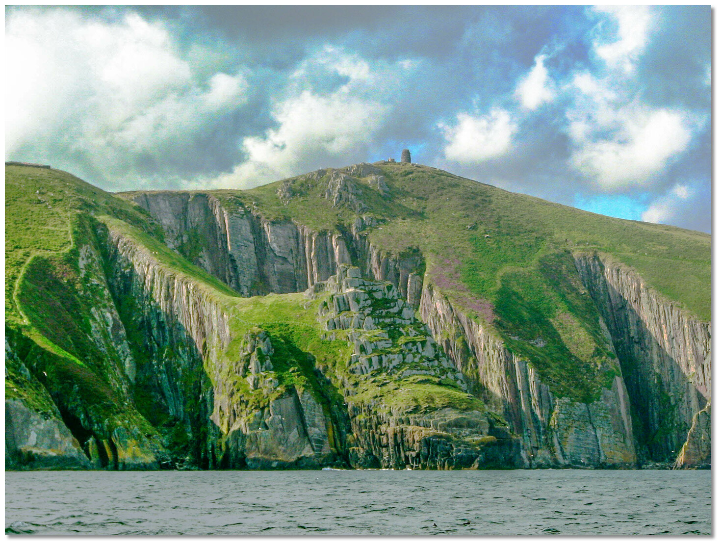
 Use Ireland’s coastal overview for Mizen Head to Loop Head for seaward approaches. The entrance to Valentia Harbour is situated 4 miles eastward of Slea Head. At the foot of the 513 metres high Mount Eagle and forming the northern entrance point of Dingle Bay and the east entrance point of Blasket Sound, Slea Head makes for an unmistakable seamark.
 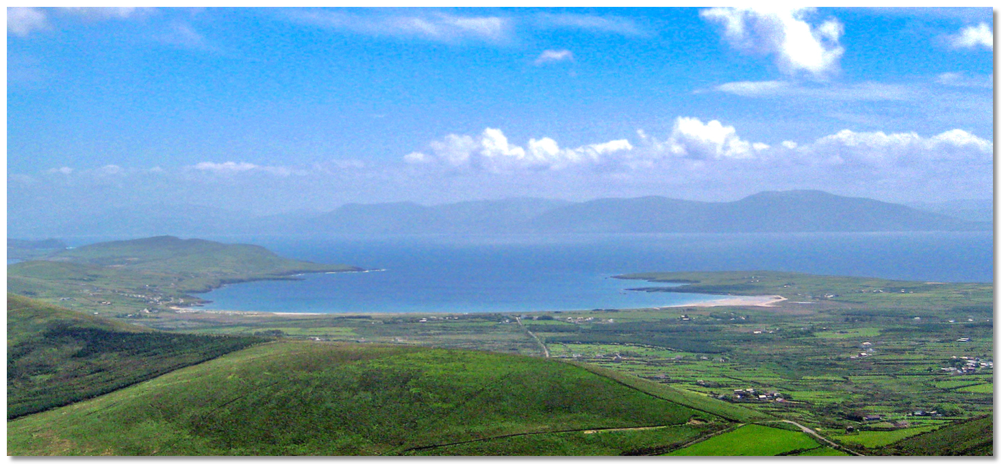 Ventry Harbour as seen from the northwest
Image: Kareem Mayan CC BY-SA 2.0
 Vessels arriving from the west or southwest will, in the first instance, most likely find the mouth of the harbour difficult to make out. When at a distance the scenery of the back-land blends in with Parkmore Point, the low lying western entry point to the bay. However, on closer approaches, two black rocks that lie off Parkmore Point, called Reenvare, will be seen and then the almost mile-wide entrance between Parkmore Point and Paddock Point becomes clear.
  The low Parkmore Point and its two black rocks called Reenvare
Image: Michael Harpur
In the event that the entrance is not sufficiently conspicuous, Valencia Lighthouse being brought a little open westward of Doulus Head, astern, will lead to the harbour.
 The Eask Tower standing on the ridge Carhoo Hill
Image: Graham Rabbits
 When approaching from the east, the conspicuous Eask Tower standing on the ridge Carhoo Hill at an elevation of 195 metres, stands 1½ miles east of the Paddock Point. With its fingerpost pointing east towards the entrance to Dingle Harbour, it provides a primary landmark on this coast. The 30 metres high Paddock Point, on the eastern side of the entrance, is made obvious by being situated upon the end of a long line of diminishing cliffs.
  The near mile wide entrance to Ventry Harbour
Image: Michael Harpur
 From the initial fix take a northeast course of approximately 304° T towards a conspicuous chapel visible on the northwestern side of the harbour. This passes Parkmore Point’s two Reenvare black rocks that are always above water standing visibly on the rocky foreshore off the point. They are clear of danger and may be approached up to a distance of 200 metres.
 The near mile-wide entrance between Parkmore and Paddock Points has depths of 14.6 to 21.9 metres, decreasing to 7.3 to 8.2 metres about 1 mile within the harbour. The western shore of the harbour is shallow but otherwise clear of danger.
 St Catherine's Church in the village of Ventry as seen in the backdrop
Image: Michael Harpur
The eastern shore, nearly a ½ mile to the north of Paddock Point and a ¼ of a mile to the southeast of Ballymore Point, has a sunken ledge that extends about ⅓ of a mile offshore with 2.9 metres of water over it. The sea breaks heavily on this ledge in a big swell and it should be avoided. Hence a middle to west side approach is advised and the 304° T towards St Catherine's Church, a conspicuous chapel, clears this shoal. A seaweed farm that is marked with Yellow beacons will be seen on the eastern side of the entry path. These have flashing lights at night.
 Cuan Pier on the west side of Pointanskoh Point
 Image: Michael Harpur
Anchor off the bay's two piers according to conditions. The western Cuan Pier is more sheltered and better for longer stays. Progressing into the harbour towards the west side to anchor off Cuan, Pointanskoh Point will be seen then the pier with a caravan park immediately above.  Cuan Pier and slipway
Image: Michael Harpur
This entire area is referred to as Cuan locally and Cuan Pier and its slipway are incorrectly spelt as Coon on the charts. Anchor about 200 metres north of the slipway in 3.0 metres or closer according to the requisite draft. There are large patches of weed that have to be avoided when anchoring but the sandy bottom is easily seen through the crystal clear waters. The sandy bottom is hard in Ventry Harbour and an effort may be required to dig the anchor in.
Cuan Pier dries out, but it has a good slipway with steps that make it a straightforward landing point. At high water it is possible to come alongside either of the piers in Ventry Bay. They both have good ladders and bollards for mooring but please avoid impeding the few fishing vessels that use them to unload their catch. There are two visitors' moorings reported off Cuan pier and one other on the village side of the bay.
Cuan pier moorings – position: 52° 07.100’N, 010° 21.900’W
Ventry Harbour village moorings – position: 52° 07.700’N, 010° 21.400’W
The moorings are rated to 15 tons and are large, coloured bright yellow and labelled VISITOR.
 Ballymore Pier
Image: Michael Harpur
The village of Ceann Trá, or Ventry, lies on the north side of the bay. Popular anchorages here are off the beach, west of the church, or in the northeast section of the bay, beneath the village, working the protection around prevailing wind conditions.
 The slip along the north side of Ballymore Pier
Image: Michael Harpur
Vessels that anchor off the north end of the bay can make use of Ballymore Pier and slip.
Why visit here?
Ventry, an Anglicisation of the Irish 'Ceann Trá'. This itself is derived from the Irish 'Fionntrá', 'the white beach' which perfectly describes the three-mile arch of sand at the head of the bay. The bay was once the main port on this peninsula and the surrounding area is steeped in history. Ventry Bay takes its name from the arc of sand along its head
Image: Michael Harpur
Just beyond Ventry in the small district of Fahan, on a promontory looking out across Dingle Bay, are the dramatic ruins of the Iron Age fort of Dunbeg or Dunbeag Promontory Fort. Dunbeg, in Irish An Dún Beag was inhabited from about the late 500 BC until around 1200 AD when it might have been an important defensive site. The fort features a central 'clochán', pronounced 'cluk- awn' stone structure, that is surrounded by sea on three sides, this fortress has walls 7 metres (23 ft) thick and girded by four rings of earthworks. An elaborately constructed souterrain, or underground escape passage by the entrance, testifies to the engineering sophistication of the medieval occupants of this lonely outpost.
 The entrance to Dunbeg Promontory Fort
Image: Jim Linwood via CC BY-SA 2.0
Excavations show that inhabitation of the site began in the late 6th-Century BC, and was used right through the Celtic period up to the 13th-Century. The excavation results did not however reveal conclusively what the site was used for; it may have been defensive or used for ritual purposes, or it may simply have just been lived in.
 Walls that have stood nearly three thousand years
Image: James Stringer via CC BY 2.0
The location of Dunbeg, on a sheer cliff promontory that projects south into Dingle Bay at the base of Mount Eagle, makes it one of the most dramatic archaeological sites on the peninsula. Though much of the original construction has long since tumbled into the sea, including a large section of the western wall during the ferocious storms of 2014, and it was further damaged by storms in the winter of 2017–18, it is still an imposing sight. It is also one of the best-preserved promontory forts in Ireland.
 A Fahan Group clochán
Image: Malcolm Neal via CC BY-SA 4.0
Forts like this are the most important relics left from Ireland’s Iron Age (500 B.C.-A.D. 500) and it is well worth the 1-hour walk it takes to traverse the 5 kilometres from Cuan Pier (via Slea Head Drive / R559). There is a 10-minute audiovisual show overviewing the site in the adjacent visitor centre that is a modern replica of the drystone construction of the 'clocháns'. Just uphill about 50 metres up the road and 100 metres from the Dunbeg Fort Visitor Centre is a thatched cottage abandoned during the Famine, around 1848, by a family named Kavanaugh. The 1845-built cottage, with furnishings, cooking utensils and farm animals offers an evocative peek into the simple lifestyles and hardship its occupants endured.
 Standing Stone Dunmore Head
Image: Tourism Ireland
Dunbeg is only a part of the Fahan Group and just beyond are the Fahan 'clocháns'. These are prehistoric small stone structures or 'beehive' huts that are thought to have originated date from around 1000 B.C. They were adopted and built here by early Christian pilgrims to the area. The entire Fahan Group includes four hundred and fourteen 'clocháns' on the southern slopes of Mount Eagle. Remarkably, many of these prehistoric dwellings, constructed in un-mortared stone, are still in a good watertight condition. There are also nineteen souterrains, eighteen standing inscribed stones, seven earthen ring forts and two sculptured crosses. The highlight of this area is always Slea Head, which features towering cliffs with incredible views of the Atlantic Ocean, sandy beaches and the Blasket Islands, but being 10 km away from the pier this is the domain of those who have some form of transport.
 View out over the Blasket Islands from Dunmore Head
Image: Tourism Ireland
To the northwest of the bay, in Ventry parish, is Rahinnane Castle which was the residence of the Knight of Kerry. The castle was built on the site of a ring fort that was built around the 7th or 8th century AD and belonged to 'Fhionnáin'. Hence he gave the area its name 'Rath Fhionnáin' 'Finan's ringfort'. Local tradition once claimed that this piece of land was the last in Ireland held by the Vikings, as it was so easily defended. The stone tower house was built in the 15th or 16th century by the FitzGeralds, hereditary Knights of Kerry who lived there until 1602. This was towards the end of the Nine Years' War, when the castle was taken by Sir Charles Wilmot. It was then ruined during the Cromwellian conquest (1649–53). The castle is on the road to Smerwick Harbour which has several of the best-preserved historic sites in the area. Smerwick Harbour is also an anchoring opportunity but should weather or time prevents a visit, it is only 6 km away.
 Rahinnane Castle overlooking the bay from the north
Image: Hauke Musicaloris
Some of Ventry Harbour's most delighted visitors arrived here on October 4th, 1939. On that day German U-Boat U-35 entered Ventry Bay on a mercy mission to land the 28 Greek sailors off of the MV Diamantis that it had torpedoed.
 The three mile long sandy beach and its sheltered waters are Verntry Bay's
principal draw today
Image: Michael Harpur
A 2009 Ventry Historical Society headstone commemorates this today and is inscribed:
- The German U-Boat U-35 landed the crew of the Greek merchant vessel Diamantis which was sunk off the coast of Cornwall, at An Dúinín in Ventry Harbour on October 4th, 1939. This magnanimous action put U-35 in considerable danger.
 Cuan is a quiet place despite its caravan park
Image: Michael Harpur
There are many wonderful walks in Ventry and its surrounds that are located amidst the very famous 'Dingle Way' drive. Several locally-produced guides and other books are available describing these walks in Ventry village.
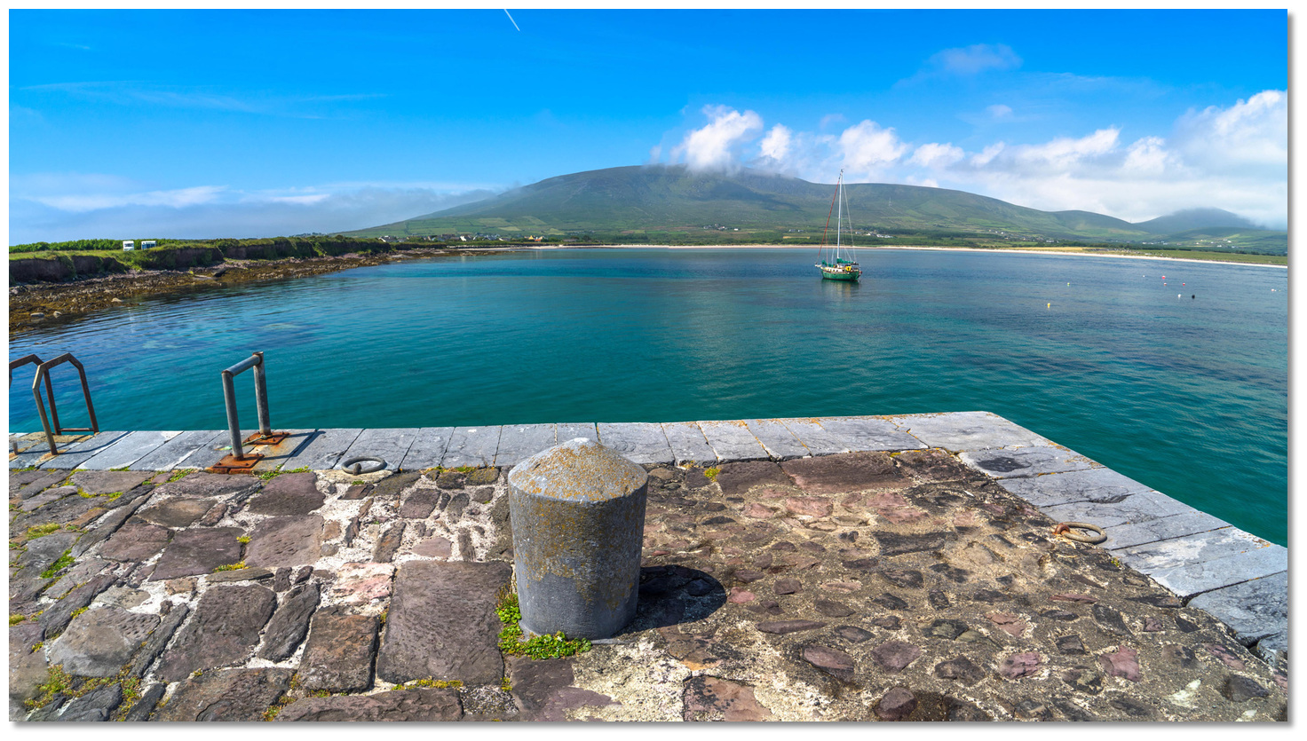
 Cuan is the best location to anchor the plan is stay a few days
Image: Michael Harpur
The bay's primary use today is that of leisure as it boasts a fine natural harbour with three miles of a white sandy beach. It is one of the most attractive and safest beaches on the west coast of Ireland. It is and no surprise that this impressive sweep of a safe beach and the sheltered bay is a favourite for swimmers, windsurfers, canoeists and sunbathing.
 The wonderfully relaxed Ventry Harbour anchorage
Image: Michael Harpur
From a boating point of view, the well-sheltered bay is just as attractive. It offers easy access and excellent anchorages in which to relax over crystal clear turquoise waters. All around are views out over a patchwork of fields backed by rolling hills leading to lofty peaks inland and big blue skies. All ending in to wonderful sunsets in between Mount Eagle and Croaghmarhin. It is a good alternate for those wishing to avoid getting sucked into the bustle and fleshpots of Dingle town in the adjacent harbour. It also makes a useful passage anchorage for those awaiting the tides in Blasket Sound.
What facilities are available?
At Cuan pier, there is nothing but the slip to land upon and no freshwater. The village of Ceann Trá , or Ventry, lies on the north side of the bay at the northern end of its three km long beach. Vessels that anchor off the village can make use of another pier and slip here. The village has a Post Office that also offers some basic provisions. There are two food venues here, bar food at the pub overlooking the pier, plus a restaurant and cafe. The village does not have a petrol station, the nearest is Dingle about five miles to the east on the R559 to which there is an occasional bus service.Any security concerns?
Never a problem known to have occurred to a vessel in Ventry Harbour.With thanks to:
Burke Corbett, Gusserane, New Ross, Co. Wexford.Ventry Harbour
Dunbeg Promontory Fort


Add your review or comment:
Please log in to leave a review of this haven.
Please note eOceanic makes no guarantee of the validity of this information, we have not visited this haven and do not have first-hand experience to qualify the data. Although the contributors are vetted by peer review as practised authorities, they are in no way, whatsoever, responsible for the accuracy of their contributions. It is essential that you thoroughly check the accuracy and suitability for your vessel of any waypoints offered in any context plus the precision of your GPS. Any data provided on this page is entirely used at your own risk and you must read our legal page if you view data on this site. Free to use sea charts courtesy of Navionics.