
_england_NIC_3407_stitch.jpg)
Five miles from the sea and dried out for extended periods at the head of a ria, the town offers complete protection from any and all conditions. With a supporting rise of the tide, the ria is marked by unlit beacons all the way up to the town basin making daylight access very straightforward. The entrance to the estuary is, however, obstructed by a shallow sandbar which needs some consideration.

Keyfacts for Kingsbridge
Facilities


Nature


Considerations


Protected sectors

Approaches

Shelter

Last modified
January 28th 2019 Summary* Restrictions apply
A completely protected location with straightforward access.Facilities
Nature
Considerations
Position and approaches

Expand to new tab or fullscreen
Haven position
 50° 16.776' N, 003° 46.495' W
This is the southern end of the Kingsbridge council visitor pontoon.
What is the initial fix?
The following Salcombe Initial Fix will set up a final approach:
 50° 12.421' N, 003° 46.666' W


What are the key points of the approach?
Offshore details are available in southwestern England’s coastal overview from Start Point to Lizard Point  . Approaches to the Kingsbridge Estuary are detailed in the Salcombe
  entry. From Salcombe, it is simply a matter of following the marks for 3½ miles up the estuary on the top end of the tide.
. Approaches to the Kingsbridge Estuary are detailed in the Salcombe entry. From Salcombe, it is simply a matter of following the marks for 3½ miles up the estuary on the top end of the tide.Not what you need?
Click the 'Next' and 'Previous' buttons to progress through neighbouring havens in a coastal 'clockwise' or 'anti-clockwise' sequence. Below are the ten nearest havens to Kingsbridge for your convenience.
Ten nearest havens by straight line charted distance and bearing:
- Salcombe - 3.2 nautical miles S
- River Avon - 3.7 nautical miles W
- Starehole Bay - 4 nautical miles S
- Hope Cove - 4 nautical miles WSW
- Hallsands - 5.3 nautical miles ESE
- River Erme - 7.1 nautical miles WNW
- Dartmouth Harbour - 8.9 nautical miles ENE
- Dittisham & The River Dart - 9.3 nautical miles NE
- River Yealm - 10.9 nautical miles W
- Paignton - 12.4 nautical miles NE
These havens are ordered by straight line charted distance and bearing, and can be reordered by compass direction or coastal sequence:
- Salcombe - 3.2 miles S
- River Avon - 3.7 miles W
- Starehole Bay - 4 miles S
- Hope Cove - 4 miles WSW
- Hallsands - 5.3 miles ESE
- River Erme - 7.1 miles WNW
- Dartmouth Harbour - 8.9 miles ENE
- Dittisham & The River Dart - 9.3 miles NE
- River Yealm - 10.9 miles W
- Paignton - 12.4 miles NE

Chart

What's the story here?
 Kingsbridge
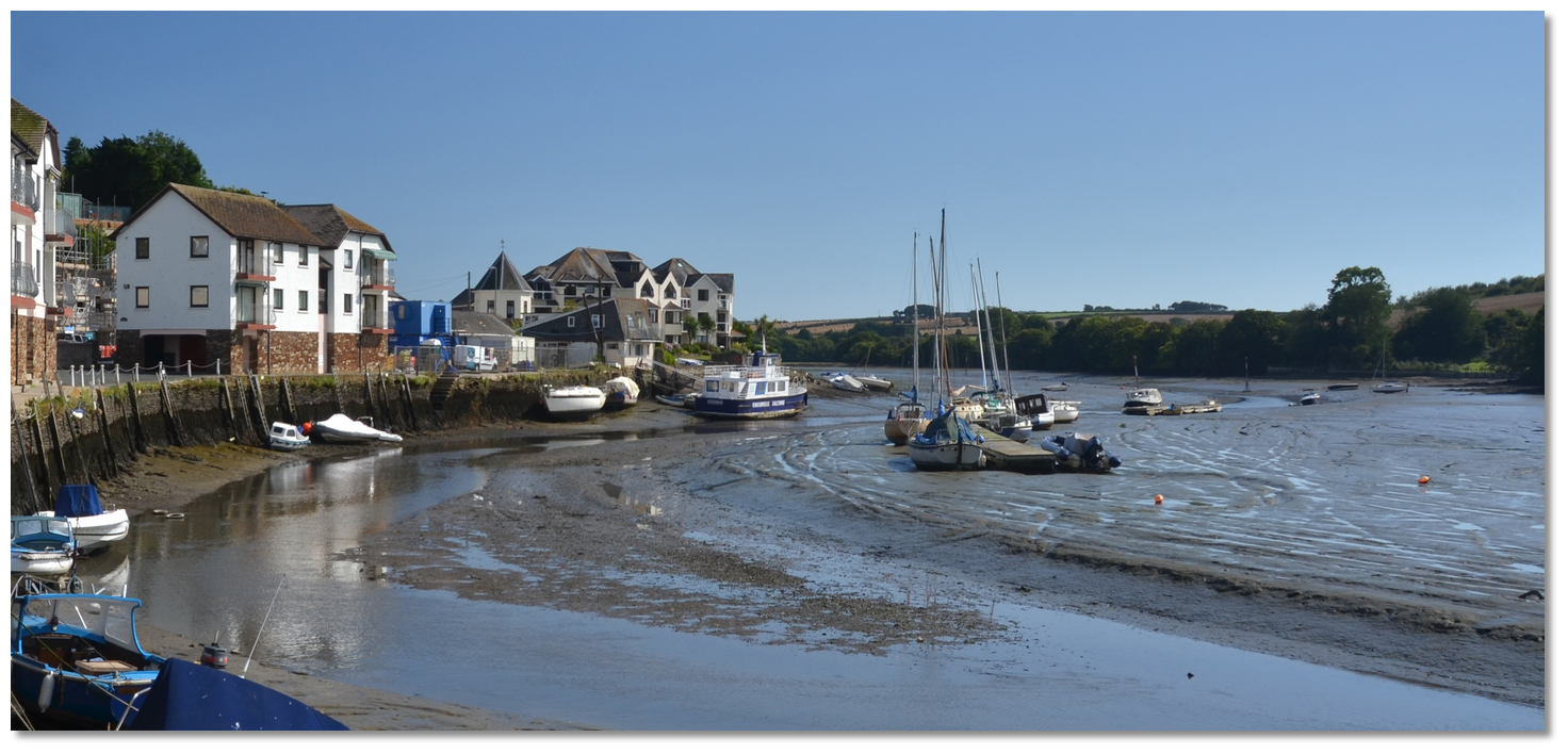
Kingsbridge Estuary is a 5 mile long dendritic Ria, or drowned River Valley. The estuary forms a natural well sheltered shallow harbour, with Salcombe near its entrance, and Kingsbridge lying at its head, 5 miles from the sea and 3.5 miles from Salcombe.
Kingsbridge receives vessels with a draft of less than 2 metres and LOA of less than 11 metres that can take to the ground at low water, as all berthing at Kingsbridge dries. Kingsbridge creek is navigable ±0230 either side of high water as the basin dries 2.8 metres at low water.
The Harbour Authority is South Hams District Council who provide a visitor’s pontoon for bilge keelers on the car park side of the basin. There are additional visitor’s berths on the seawall to the north of the pontoon more suitable for a long keeled boat to dry. Fender boards are available on request and it is important to note that visitor mooring fees and Harbour dues are payable, irrespective of where the boat is moored.
 Council Pontoon Kingsbridge
Image: Michael Harpur
The Harbour Authority charges (2019) £2.00 metre, £10.00 per week for moorings, or Harbour Dues of £1.00 metre, £5.00 per week, for vessels anchoring. No berthing is allowed without permission of the Harbour Master.
It is advisable to check availability before proceeding up the estuary
 +44 1548 843791,
  Ch. 14 [SALCOMBE HARBOUR],
  salcombe.harbour@southhams.gov.uk, emergency out-of-hours P: +44 1803 867034.
 How to get in?
_with_kingsbridge_seen_in_the_distance.jpg) The Salt Stone (right) with Kingsbridge seen in the distance
The Salt Stone (right) with Kingsbridge seen in the distanceImage: Michael Harpur
 Use southwestern England’s coastal overview from Start Point to Lizard Point for seaward approaches. The approaches to the Kingsbridge Estuary are detailed in the Salcombe entry. From Salcombe, it is simply a matter of following the marks for 3½ miles up the estuary on the top end of the tide. There is a six-knot zone from the Salcombe Harbour Hotel to the Kingsbridge Basin and speed limits are vigorously enforced, so ease it back.
Leave the Salt Stone well to starboard after which a series of red and white poles leads for the final 2 miles up to the quay. The first of these poles will be seen about 400 metres northwest of the Salt Stone beacon immediately northeast of Heath Point.
Stick to the poles, all passed to port, and ignore a secondary channel marked by a line of red buoys that will be encountered ½ a mile northward after Charleton Point where the estuary starts to dry.
This leads up to Balcombe Lake. The main channel to Kingsbridge continues close west of this and then veers off gradually to follow the westward fork.
 The Kingsbridge ferry seen on its berth at low water from the north
Image: Michael Harpur
Do not berth at the New Quay to starboard or at the first pontoons encountered as they belong to the Kingsbridge Ferry or are privately owned. Continue up to the end of the long narrow town basin and the visitor berths will be found clearly marked between the residents’ pontoon and the quay wall on the western side of the basin.
 The council pontoon
Image: Michael Harpur
Berth at the marked Council pontoon in the town centre basin or the wall on the port side as directed by the Harbour Master. Why visit here?
Kingsbridge was mentioned as early as 962 in an Anglo-Saxon charter of King Edgar. The town formed around a bridge which was built in or before the 10th-century between the royal estates of Alvington, to the west, and Chillington, to the east, giving it the name of Kyngysbrygge, the ‘King's bridge’. St_Edmond's Church, Kingsbridge
Image: Robert Cutts via CC ASA 4.0
The town’s situation at the centre of the fertile South Hams and at the head of the Kingsbridge Estuary, which provides wide, calm, tidal waters running inland, made it an ideal site for settlement. An Iron Age Hill Fort exists to the south of Kingsbridge and recent geophysics suggest that there could be further prehistoric features in the area. Exeter was the principle Romano-British town in the southwest but a Roman coin was found in Kingsbridge and Roman Pottery in Salcombe.
 Kingsbridge Cenotaph
Image: stickman via CC ASA 4.0
Kingsbridge first appears as Kyngysbrygge in a 962 Anglo-Saxon charter for land and, though evidence is scarce, it is believed that a planned urban burgh, Saxon fortified town, was established here in the 10th-century. This is thought to be on the spur of land which rises above the bridging point broadly in the position of the present Mill Street.
 Clock on the top of the old Town Hall building
Image: stickman via CC ASA 4.0
Poor or non-existent roads in the medieval period meant that most goods were transported by boat around the shores of the estuary and the adjacent coast, and this led to the growth of a flourishing coastal trade at Kingsbridge, at the head of the estuary. Shipbuilders in the Kingsbridge Estuary underpinned this trade providing ships for the crown as early as 1310 and this tradition continued right up to the latter part of the 19th-century.
Between the 14th and 16th centuries, local slate became a major export. Thousands of tons of blue slate and building stone from quarries in Charleton, Stokenham and other South Pool parishes, was then passed from Kingsbridge down the estuary to ports along the coasts of southern England. The manor remained in possession of the Abbot until the Dissolution of the Monasteries, when it went into private hands. The combination of poor roads and the flanking superior ports of Plymouth and Dartmouth then caused Kingsbridge to stagnate in the 17th century where it fell back to concentrate on exporting its agricultural products, locally rather than further afield.
 Kingsbridge high street
Image: cowbridgeguide.co.uk via CC ASA 4.0
Fortunes then changed during the Napoleonic wars, which increased demand for local products and the quays of Kingsbridge were again busy. The town mills were converted into a woollen manufactory, which produced large quantities of cloth, and serge manufacture was introduced early in the 19th-century. After Napolean was defeated, Kingsbridge and Salcombe carved out a profitable niche in the import of fruit, and they were responsible for importing over eighty percent of fresh citrus fruit to England during the 19th Century. The town also exported cider, corn, malt, and some slate which remained. The fruit trade began to decline throughout the 1870s before virtually vanishing by the 1880s when the fruit crop was hit by disease and sail finally gave way to steam and iron vessels. The boatmakers of the Kingsbridge Estuary were not geared up to compete with the industrial yards of England in the building of steel ships, and it fell back to building small boats mainly for locals.
 Compton Castle as seen in 1974 when it was used as a cafe
Image: Johnragla via CC ASA 4.0
Trade continued somewhat until the coming of the railway in 1893. However, paddle steamers continued to make daily trips between Kingsbridge and Salcombe and carried passengers to Plymouth for their shopping excursions during the 19th and early 20th centuries. A 'New Quay' was built and a deepwater channel dredged to allow the ferries and trading vessels to berth.
Kingsbridge remains to this day the area's main market town and is broadly seen as its 'capital'. The only commercial shipping from its quays today is the Rivermaid which continues the paddle steamer tradition of plying the estuary between Kingsbridge and Salcombe at high water. The town’s quays have moved focus from commercial to leisure boating.
Kingsbridge retains a lot of charm. The town is rich in architecture retaining many 18th and 19th-century buildings that are home to a variety of locally owned and interesting shops. The Shambles, a market arcade, was rebuilt in 1796 retaining its 16th-century granite colonnade piers. A farmers' market is held on the Quay on the first and third Saturday of the month.
 The Rivermaid Ferry
Image: Chris Sampson
The town tells its story in its own museum now housed in what was formerly a grammar school that dates back to the 17th-century. It is called the ‘Cookworthy Museum’ and is named after William Cookworthy, 1705-1780. Cookworthy was born at Kingsbridge and worked as an apothecary in Plymouth when he became the first person in Europe to exploit the deposits of kaolin, also called china clay, in Cornwall. He then went on to develop porcelain manufacturing in England.
From a boating perspective, a trip up calm tidal waters running inland to Kingsbridge is a must for vessels that can take to the mud. The dramatic scenery within this Area of Outstanding Natural Beauty is the habitat for a variety of wildlife. Herons, egrets and shags, and the smartly dressed shellducks which, surprisingly nest in old rabbit burrows, abound. Closer to the entrance there is a small chance of seeing grey seals or even porpoises. The ancient market town is a joy and it is the best place to provision on the estuary with a choice of supermarkets. For fin keel vessels that do not lend themselves to its berthing arrangements, a tender run should at least be considered or even letting the Rivermaid take the strain.
What facilities are available?
Kingsbridge also offers a quay with a launching slipway adjacent to the large car park. Vessels up to 1.5 metres draft can be slipped dependent on the tide.Kingsbridge is a vibrant market town with access to a number of facilities including two supermarkets, a Morrisons and a Tesco Store. There is a quayside leisure centre where showers are available, cinema, tourist information centre and a wide range of shops. Street markets take place on Tuesdays and Thursdays and a local Farmers Market takes place on the Quay on the first Saturday of each month.
The town is linked to Plymouth and Dartmouth by the A379 road, and to Salcombe and Totnes by the A381.
With thanks to:
eOceanic_england_Chris Sampson.jpg)
Kingsbridge, Devon, England
Image: eOceanic thanks Chris Sampson
_england_NIC_3390.JPG)
New Quay Kingsbridge
Image: eOceanic thanks Michael Harpur
_england_NIC_3367.JPG)
Kingsbridge at low water
Image: eOceanic thanks Michael Harpur
_england_NIC_3379.JPG)
Kingsbridge ferry on its berth and the first private pontoon encountered
Image: eOceanic thanks Michael Harpur
Aerial Overviews


Add your review or comment:
Please log in to leave a review of this haven.
Please note eOceanic makes no guarantee of the validity of this information, we have not visited this haven and do not have first-hand experience to qualify the data. Although the contributors are vetted by peer review as practised authorities, they are in no way, whatsoever, responsible for the accuracy of their contributions. It is essential that you thoroughly check the accuracy and suitability for your vessel of any waypoints offered in any context plus the precision of your GPS. Any data provided on this page is entirely used at your own risk and you must read our legal page if you view data on this site. Free to use sea charts courtesy of Navionics.