England Ireland Find Havens
England Ireland Find Routes
Boat
Maintenance
Comfort
Operations
Safety
Other


NextPrevious

Rounding the southeast corner of Ireland via the 'Offshore Route'

Tides and tools
Overview


Be the first
to comment

What is the route?
This is a set of waypoints for rounding Carnsore Point, Ireland’s south-eastern corner, by the 'offshore route'. The sequence of description is from south and westward or coastal clockwise, passing:

  • • Outside the Lucifer Bank

  • • Seaward of Tuskar Rock and through the Inshore Traffic Zone of the Tuskar Rock Trafic Separation Scheme

  • • South of the Barrels East Cardinal Mark

  • • South of the Coningbeg Super Buoy.

Those looking for the 'inshore route' may find it detailed in Ireland's South Coast Description Rosslare Harbour to Cork Harbour Route location. The preceding east coast waypoints and coastal description are available in the Dublin to Rosslare Harbour Route location.

Why sail this route?
Boats approaching from Saint George's Channel, or the east coast of Ireland, and rounding Carnsore Point, Ireland’s south-eastern corner, have two primary options:

  • • The 'offshore route', detailed here, that rounds the corner outside, or on the eastern or seaward side, of Tuskar Rock using the Inshore Traffic Zone, of the Tuskar Rock Traffic Separation Scheme. This the continues southwestward to pass the Barrels East Cardinal Mark Light Buoy, to pass around the Saltee Islands to the south of Coningbeg Super Buoy.

  • • The 'inshore route' that comes close in and around Carnsore Point and heads almost directly west to pass through St. Patrick’s Bridge, between the Saltee Islands and the mainland.

The 'inshore route' is the preferred leisure craft route for many reasons. It avoids the complications of the Inshore Traffic Zone, shortens the approach distance and secures smoother inshore waters. In reasonable conditions, with the benefit of good visibility plus a good breeze, or a reliable engine, the inshore option offers the leisure boats the better option and more interesting passage. Waypoints and coastal directions are available in the Southern Ireland coastal description Rosslare Harbour to Cork Harbour Route location.

But this 'offshore route' is much more straightforward and the best approach to take at night, with poor visibility or in uncomfortable weather.

Tidal overview
Today's summary tidal overview for this route as of Tuesday, November 5th at 15:53. Tidal stream around the southeast corner of Ireland generally run in a north by northeast / south by southwest direction. Close northeast of Tuskar Rock the tides turn northeast at Dover -0500 (Dublin -0530), southeast at Dover +0100 (Dublin +0030) and attaining rates of up to 3 - 3½ kn. The direction of streams are affected by those from South Shear Channel further northward and timing, direction and rate vary considerably between Tuskar Rock and the mainland coast.

Southeast Steam

(HW Dover +0100 to -0500)

Now

(Tidal flow )


Ends in 04:06:48

(Tue 13:35 to 20:00)

Northeast Stream

(HW Dover -0500 to +0100)


Starts in 04:06:47

(Tue 20:00 to 02:00)

What are the navigational notes?
Please use our integrated Navionics chart to appraise the route. Navionics charts feature in premier plotters from B&G, Raymarine, Magellan and are also available on tablets. Clicking the 'Expand to Fullscreen' icon opens a larger viewing area in a new tab.

Expand to
new tab or fullscreen
Please zoom out (-) if all of the waypoints are not displayed.
The above plots are not precise and are indicative only.

THE OFFSHORE ROUTE OVERVIEW

The offshore route is a straightforward and open water approach to rounding Carnsore Point, Ireland’s south-eastern corner. But it is a seaway that has to be treated with the utmost of respect as between Coningbeg Super Buoy, situated four miles south of the Saltee Islands, and Tuskar Rock there are many rocks, shoals and shallows.

LISTED WAYPOINTS

The complete course is 33.40 miles from the waypoint '¼ of a mile east of Southeast Blackwater East Cardinal' to '½ a mile south of the Coningbeg Lighted Buoy ' tending in a south westerly direction (reciprocal north easterly).

¼ of a mile east of Southeast Blackwater East Cardinal, 52° 25.644' N, 006° 7.980' W
Eastern Cardinal Mark, Q(3) 10S, for the Blackwater Bank that resides to the north of the Lucifer Bank.

       Next waypoint: 13.59 miles, course 187.31°T (reciprocal 7.31°T)

1 mile east of Tuskar Rock , 52° 12.175' N, 006° 10.800' W
Tuskar Rock Lighthouse Q(2) 7.5s situated on a 5-metre high rock islet which is the outermost danger of this corner of Ireland, residing 6 miles east by north-east of Carnsore Point. This position is in about the middle of the Inshore Traffic Zone to seaward of the rock, of the Tuskar Rock Traffic Separation Scheme.

       Next waypoint: 1.56 miles, course 208.63°T (reciprocal 28.63°T)

½ a mile east of the South Rock Buoy, 52° 10.810' N, 006° 12.015' W
South Rock East Cardinal Q (6) + LFl 15 is moored 1½ miles South of Tuskar Rock marking the South Rock with 2.4 metres of water over it.

       Next waypoint: 6.86 miles, course 244.63°T (reciprocal 64.63°T)

½ a mile south of the Barrels, 52° 7.865' N, 006° 22.108' W
Barrels East Cardinal Q (3) is marked by a buoy moored about 2 miles south of Carnsore Point. It marks the drying Barrels Rock situated about 1.8 miles south by south-west of Carnsore Point.

       Next waypoint: 11.39 miles, course 242.78°T (reciprocal 62.78°T)

½ a mile south of the Coningbeg Lighted Buoy , 52° 2.640' N, 006° 38.567' W
The Coningbeg Super Buoy Q(6) + L Fl 15s is moored about 1.7 miles south by south-west of the Coningbeg Rock. It has a red hull with the name painted in white letters on each side.


PASSAGE OVERVIEW

The Lucifer Bank is located 5 miles east by south-east from Rosslare Point. It is about 1.5 miles in length, lying in a north-northeast and south-southwest direction, and nearly ⅔ of a mile wide, with 3.5 to 6.5 metres over it. Both New Ground and Lucifer are marked by an East Cardinal, positioned well east and south of these banks, on the seaward side.

Lucifer - East Cardinal VQ (3) 5s position: 52° 17.035’N, 006° 12.671’W


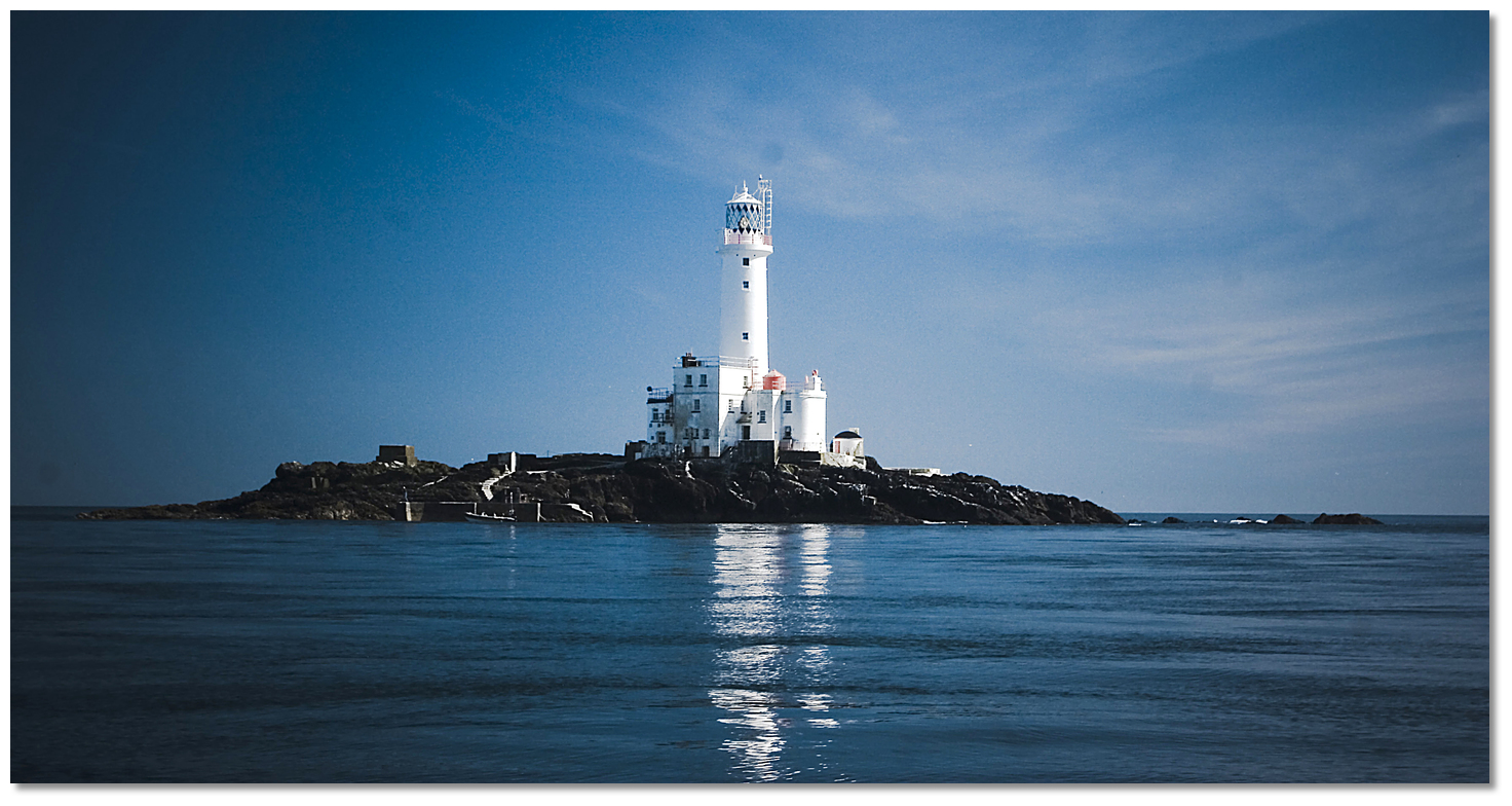
Tuskar Rock
Photo: Tom Furlong


Tuskar Rock is the outermost danger of this corner of Ireland, residing 6 miles east by north-east of Carnsore Point. It is 5 metres high and located on a rocky bank with depths of less than 3 metres around it, except on the east side that is steep-to. A light is shown from a conspicuous lighthouse structure, 34-metres high, standing on the rock.

Tuskar - Lighthouse Q(2) 7.5s position: 52°12.175'N, 006°12.445'W


On the west side, mainland side, of the rock, the deep-water channel is 1½ miles wide between the dangers west of the rock and The Bailies bank and this is also a viable option. The traffic separation scheme is established within 11 miles south-east of Tuskar Rock. Vessels proceeding north should enter St. George’s Channel through the outer lane and vessels proceeding south should leave the channel through the inner lane. Northbound vessels should be aware that outbound vessels from ports on the east side of the Irish Sea, generally head across St. George’s Channel in order to enter the south and inner traffic lane.

The course then passes ½ a mile east of the South Rock Light buoy that is moored 1½ miles South of Tuskar Rock. The South Cardinal marks the South Rock with 2.4 metres of water over it.

South Rock - South Cardinal Q (6) + LFl 15s position: 52° 2 10.810’N, 006° 12.848’W


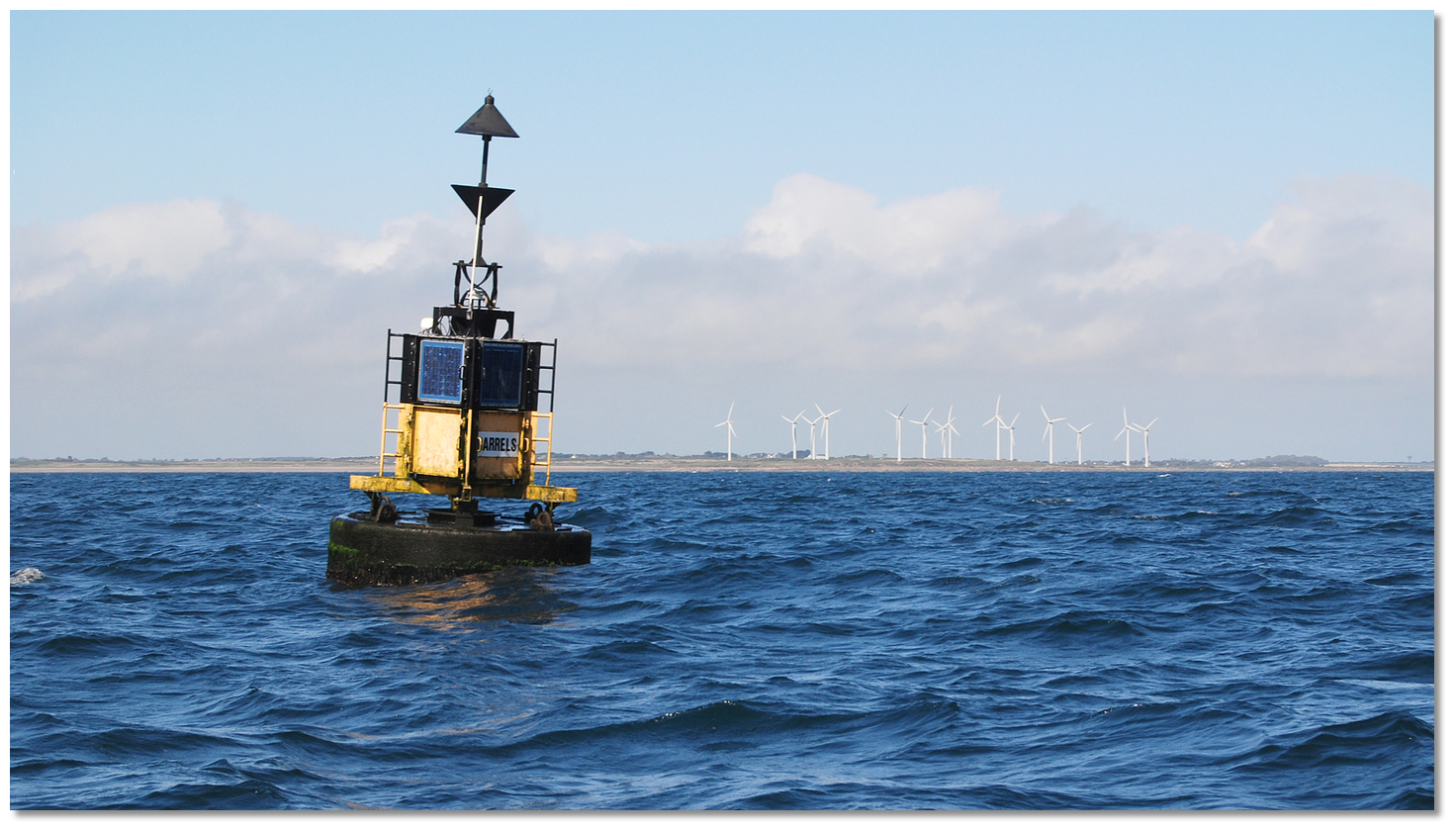
Barrels East Cardinal with Carnsore Point in the backdrop
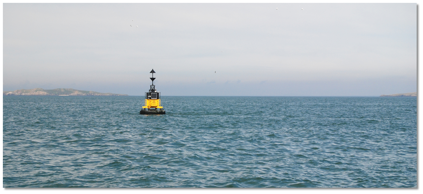
Photo: Burke Corbett


From here the course turns southwestward to pass a ½ mile south of the Barrels East Cardinal.


Barrels – East Cardinal Q (3) 10s position: 52° 08.363’N, 006° 22.108’W

The buoy is moored about 2 miles south of Carnsore Point and it marks the drying Barrels Rocks that lie about 1.8 miles south by south-west of Carnsore Point.
Please note

Once the Barrels Buoy has been rounded there is the option to reappraise the route and turn to cross St. Patrick’s Bridge described in the Dublin to Rosslare Harbour Route locationpassing between the Saltee Islands and the mainland.


Bore Rocks East Cardinal with Great Saltee in the backdrop
Photo: Burke Corbett


This path to Coningbeg will next have a vessel pass about a mile to the south-east of the Bore Rocks east cardinal.

Bore Rocks - East Cardinal Q(3) 10S position: 52° 52 06.074’N, 006° 31.871’W

North of the Bore Rocks East Cardinal are the Bohur shoals, and one mile north-west of a line drawn between Bore Rocks Cardinal and the Coningbeg Lighted Buoy, lie three separate and dangerous clusters of rock: Brandies, Coningmore and Coningbeg.

Coningbeg Lighted Buoy is moored about 1.7 miles south by south-west of the Coningbeg Rock. It has a red hull with the name painted in white letters on each side. Vessels should pass to the south of the lighted buoy or close north.

Coningbeg Super Buoy - Q(6) + L fl 15s position: 52° 03.198’N, 006° 38.567’W

West of the island Ballyteige Bay opens and Hook Head Lighthouse will be visible. There are no further obstructions on any course steered to pass a mile southward of Hook Head, as available in Ireland's South Coast Description Rosslare Harbour to Cork Harbour Route location.
What is the best sailing time?
May to September is the traditional Irish Sailing season with June-July offering the best weather. June and July’s statistical incidence of strong winds are however two days of winds up to force seven. As such, depending on personal sailing preferences, a vessel may expect to be held-up or enjoy robust sailing conditions. Ireland is not subject to persistent fog. Statistically complete days of persistent fog occur less than once in a decade.

Are there any security concerns?
Never been a security issue known to have occurred sailing off the Irish coast.

With thanks to:
eOceanic with the help of Burke Corbett.


Expand to
new tab or fullscreen


A photograph is worth a thousand words. We are always looking for bright sunny photographs that show this route and its identifiable features at its best. If you have some images that we could use please upload them here. All we need to know is how you would like to be credited for your work and a brief description of the image if it is not readily apparent. If you would like us to add a hyperlink from the image that goes back to your site please include the desired link and we will be delighted to that for you.


Add your review or comment:

Please log in to leave a review of this route.

Please note eOceanic makes no guarantee of the validity of this information, we have not sailed this route and do not have first-hand experience to qualify the data. Although the contributors are vetted by peer review as practised authorities, they are in no way, whatsoever, responsible for the accuracy of their contributions. It is essential that you thoroughly check the accuracy and suitability for your vessel of any waypoints offered in any context plus the precision of your GPS. Any data provided on this page is entirely used at your own risk and you must read our legal page if you view data on this site.