


The secure shelter inside the harbour is good, although it can be exposed to swell and also squalls in winds from the northwest. In all reasonable weather conditions the access is straightforward though care is required to avoid local boats and a daylight entry is advisable.

Keyfacts for Teelin


Nature


Considerations

Protected sectors


Summary
A good location with straightforward access.Nature
Considerations
Position and approaches

Haven position
 54° 37.486' N, 008° 37.879' W
this is the position of Teelin Harbour pierhead,
What is the initial fix?
 54° 37.190' N, 008° 37.532' W


Not what you need?
- White Strand Bay - 5.5 nautical miles WNW
- Malin Beg Bay - 5.9 nautical miles WNW
- Killybegs - 6.6 nautical miles E
- Glen Bay - 6.6 nautical miles NW
- Rathlin O'Birne Island - 7.1 nautical miles WNW
- Mullaghmore - 11.5 nautical miles SE
- Inishmurray - 11.7 nautical miles S
- Dawros Bay - 12.3 nautical miles NNE
- Church Pool & Portnoo - 14.8 nautical miles NNE
- Donegal Town Harbour - 14.8 nautical miles E
- White Strand Bay - 5.5 miles WNW
- Malin Beg Bay - 5.9 miles WNW
- Killybegs - 6.6 miles E
- Glen Bay - 6.6 miles NW
- Rathlin O'Birne Island - 7.1 miles WNW
- Mullaghmore - 11.5 miles SE
- Inishmurray - 11.7 miles S
- Dawros Bay - 12.3 miles NNE
- Church Pool & Portnoo - 14.8 miles NNE
- Donegal Town Harbour - 14.8 miles E

Chart

How to get in?
 The 'Erris Head to Malin Head' coastal description provides approach information to the suggested initial fix. Vessels approaching from the south should select the northeast bound
  sequenced description; vessels approaching from the north should select the southwest bound sequence; western approaches may use either description.
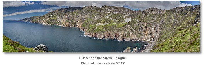
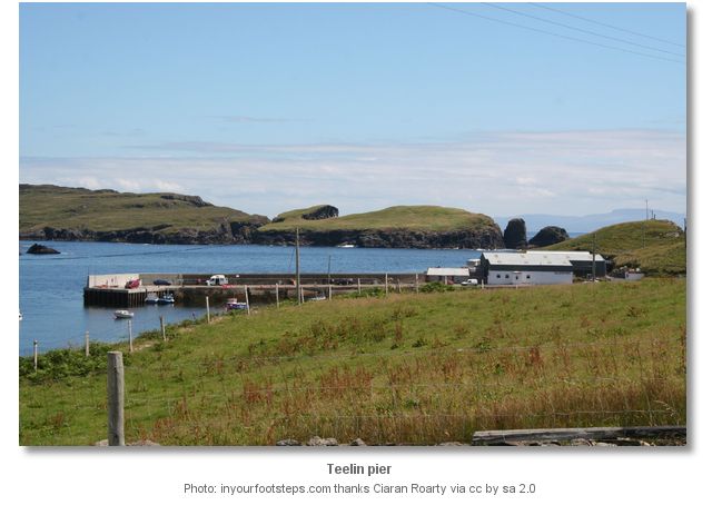
Teelin, Irish : Teileann meaning Dish, has a narrow entrance to its harbour which is situated two miles east of Cabrigan Head between Teelin Point and Cladnageragh and has a navigable width of less than 200 metres which is not easily seen until fairly close, even in daylight. The picturesque natural harbour at Teelin has a 15 metre long deep water pier on the west coast of the bay. The deep water pier offers secure shelter in most conditions and has a depth of 3 metres for alongside berths, although it is often difficult to find a space there as local boats are often tied outside each other.
There is a reasonable anchorage just inside Teelin Point. It is suitable for a night stop but is exposed to south and southwest swell which is sometimes very heavy and it is also prone to severe squalls in winds from the northwest which come down off the mountain. Four seasonal visitor moorings are available at this location.
The village of Teelin, 0.5 mile further up the west shoreline from the harbour, also has a small quay that dries and has a boat launching slip. Care should also be taken to avoid the mussel rafts that are situated in the bay.
Why visit here?
Teelin is a small fishing port overlooked by the mountain Slieve League, and its picturesque deep harbour is well protected from the sea by the surrounding land masses on either side of the inlet leading into the harbour area.Teelin was once an important port and is one of the first settlements shown on the earliest maps of Ireland. Today the village is still noted for its fishing but is better known for traditional fiddle music. The renowned folklore collector Sean O' hEochaidh, who was born there, claims that Teelin can be equally known as “Teelin of the Fish” or “Teelin of Tradition and Music”. Teelin's fishing harbour is small compared to its near neighbour Killybegs eight miles to the east, but as recently as 1900 it was the leading cod fishing port of Ireland. Teelin is a Gaeltacht, Irish speaking village and is one of the centres of learning for students of the Irish language.
Although lacking in amenities for the visiting sailor, Teelin is a popular passage anchorage being strategically placed as the first secure anchorage east of Glen Head, and is a convenient point of departure for crossing to Broadhaven or Erris Head. It does have some visitor moorings, a boat launching slipway, fresh water and possibly diesel available at the pierhead, and a small shop for limited fresh provisions together with the essential excellent pub at Teelin village half a mile up the road from the pier. The village of Carrick, Irish : An Charraig, 3 miles further up the road at the head of the inlet also has a good shop supplying fresh provisions.
What facilities are available?
There are limited facilities at this location, fresh water and possibly diesel are available at the pierhead, a boat launching slipway, a shop for provisions and a pub in Teelin village. There is a further shop for fresh provisions at the nearby village of Carrick, or for major restocking and other services best try Killybegs.With thanks to:
inyourfootsteps.com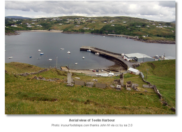


The following video presents a beautiful sunset in teelin harbour filmed from a yacht at anchor.


Add your review or comment:
Iain Miller wrote this review on Oct 19th 2017:
Along the coast towards Slieve League lives Sail Rock, http://uniqueascent.ie/sail_rock_guide
Average Rating: UnratedIain Miller wrote this review on Oct 19th 2017:
Along the coast towards Killybegs is Muckross Head, http://uniqueascent.ie/muckross_guide.
Average Rating: UnratedPlease log in to leave a review of this haven.
Please note eOceanic makes no guarantee of the validity of this information, we have not visited this haven and do not have first-hand experience to qualify the data. Although the contributors are vetted by peer review as practised authorities, they are in no way, whatsoever, responsible for the accuracy of their contributions. It is essential that you thoroughly check the accuracy and suitability for your vessel of any waypoints offered in any context plus the precision of your GPS. Any data provided on this page is entirely used at your own risk and you must read our legal page if you view data on this site. Free to use sea charts courtesy of Navionics.