
Portavogie Harbour is located on the northeastern coast of Ireland, nine miles northeast of the entrance to Strangford Lough and immediately north of Plough Point. It is a small, active and crowded fishing port that welcomes leisure craft but is not specifically set up to receive them.
The active commercial harbour offers complete protection from all conditions within its basins. Access is straightforward in offshore conditions, at any stage of the tide, night or day.


Keyfacts for Portavogie Harbour


Last modified
November 8th 2022 Summary
A completely protected location with straightforward access.Facilities


Nature


Considerations


Position and approaches

Expand to new tab or fullscreen
Haven position
 54° 27.405' N, 005° 26.290' W
This is in Portavogie Harbour's Middle Basin.
What is the initial fix?
The following Portavogie Harbour Initial Fix will set up a final approach:
 54° 27.440' N, 005° 24.867' W


What are the key points of the approach?
Offshore details are available in northeast Ireland’s Coastal Overview for Malin Head to Strangford Lough  .
.
.- From the north keep outside of Skullmartin, Burial Island and the McCammon Rocks.
- From the south pass inshore or offshore of the Butter Paddy and the South Rocks but offshore of North Rocks and Plough Rock.
- Find Plough Rock Bouy and steer due west onto the outer pier head's tower where the entrance is situated.
Not what you need?
Click the 'Next' and 'Previous' buttons to progress through neighbouring havens in a coastal 'clockwise' or 'anti-clockwise' sequence. Below are the ten nearest havens to Portavogie Harbour for your convenience.
Ten nearest havens by straight line charted distance and bearing:
- Ballyhalbert Bay - 2.2 nautical miles N
- Kircubbin - 4.1 nautical miles WNW
- Ballywalter - 5 nautical miles NNW
- Ballyhenry Bay - 6 nautical miles SW
- Portaferry - 6.1 nautical miles SW
- Strangford Harbour (Strangford Village) - 6.5 nautical miles SW
- Audley's Roads - 6.6 nautical miles SW
- Audley’s Point - 6.6 nautical miles SW
- Pawle Island - 6.6 nautical miles W
- Ringhaddy Sound - 6.8 nautical miles W
These havens are ordered by straight line charted distance and bearing, and can be reordered by compass direction or coastal sequence:
- Ballyhalbert Bay - 2.2 miles N
- Kircubbin - 4.1 miles WNW
- Ballywalter - 5 miles NNW
- Ballyhenry Bay - 6 miles SW
- Portaferry - 6.1 miles SW
- Strangford Harbour (Strangford Village) - 6.5 miles SW
- Audley's Roads - 6.6 miles SW
- Audley’s Point - 6.6 miles SW
- Pawle Island - 6.6 miles W
- Ringhaddy Sound - 6.8 miles W


What's the story here?
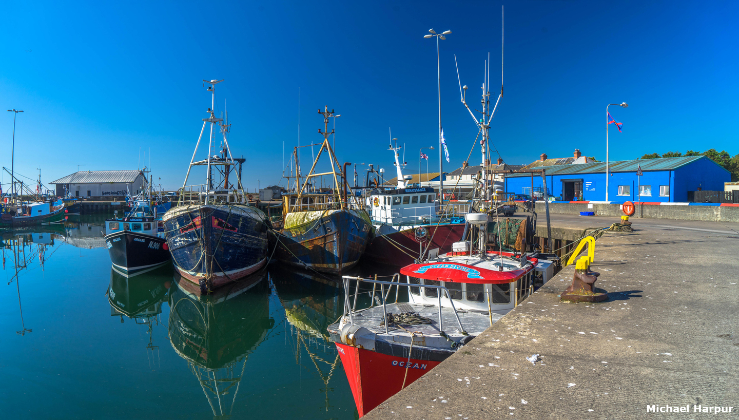
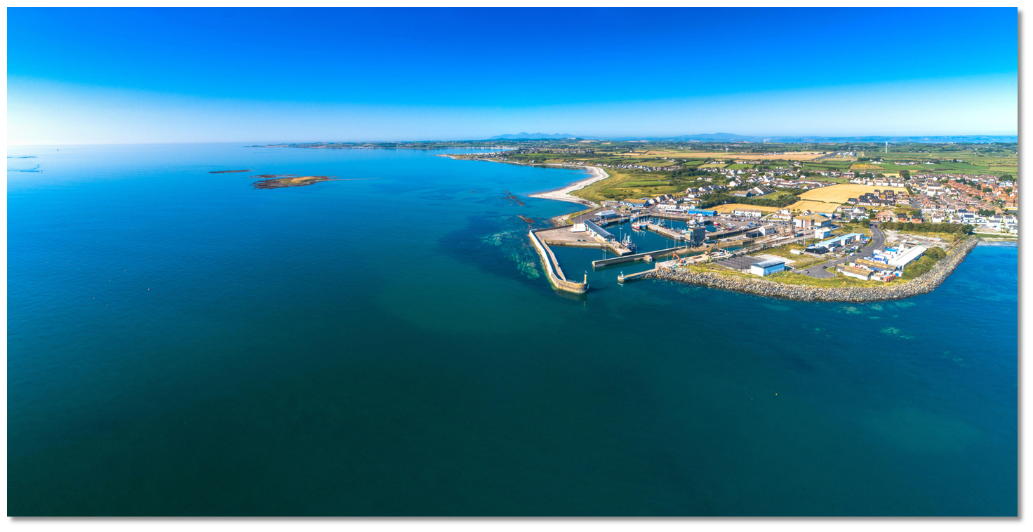
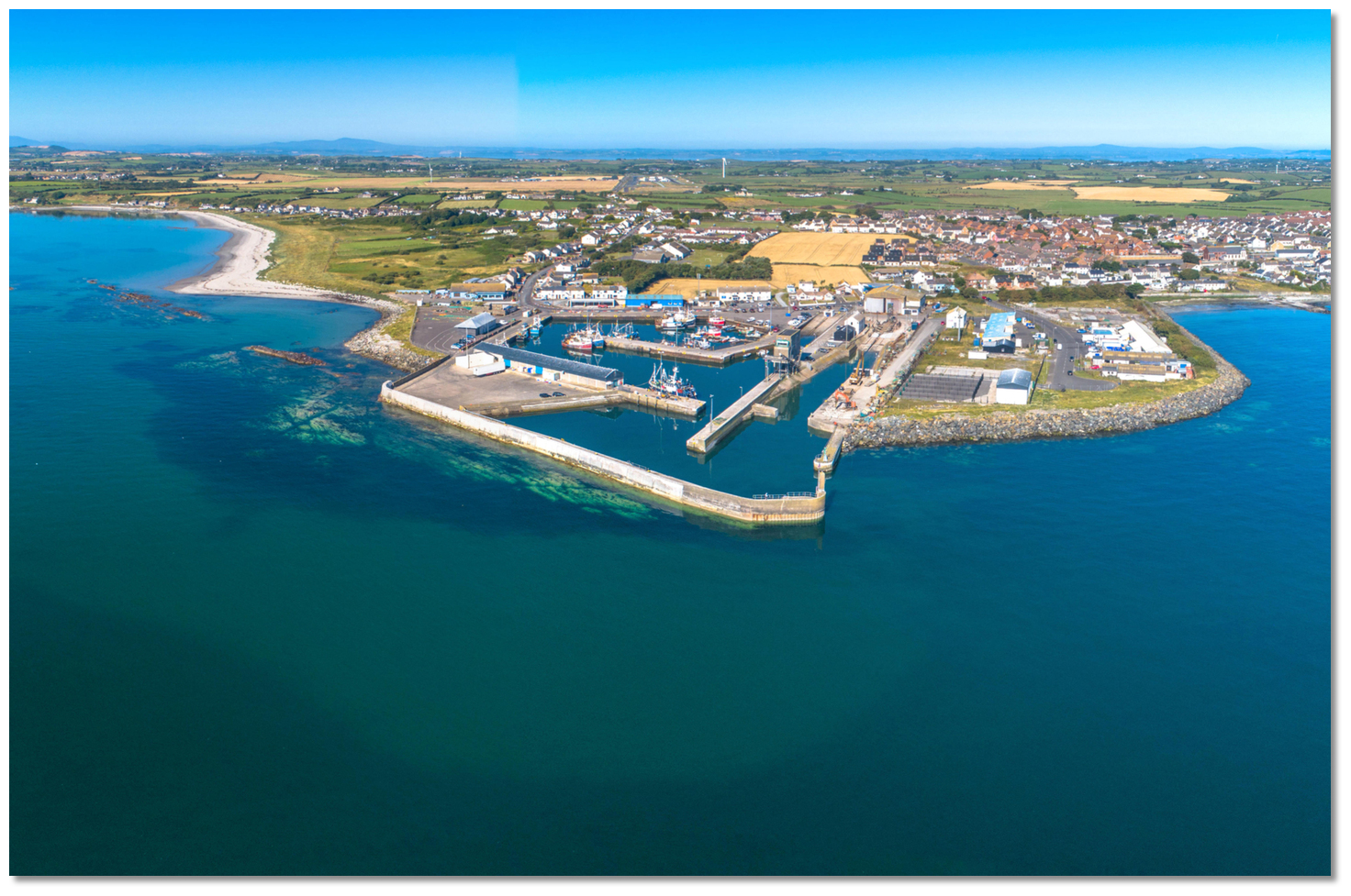
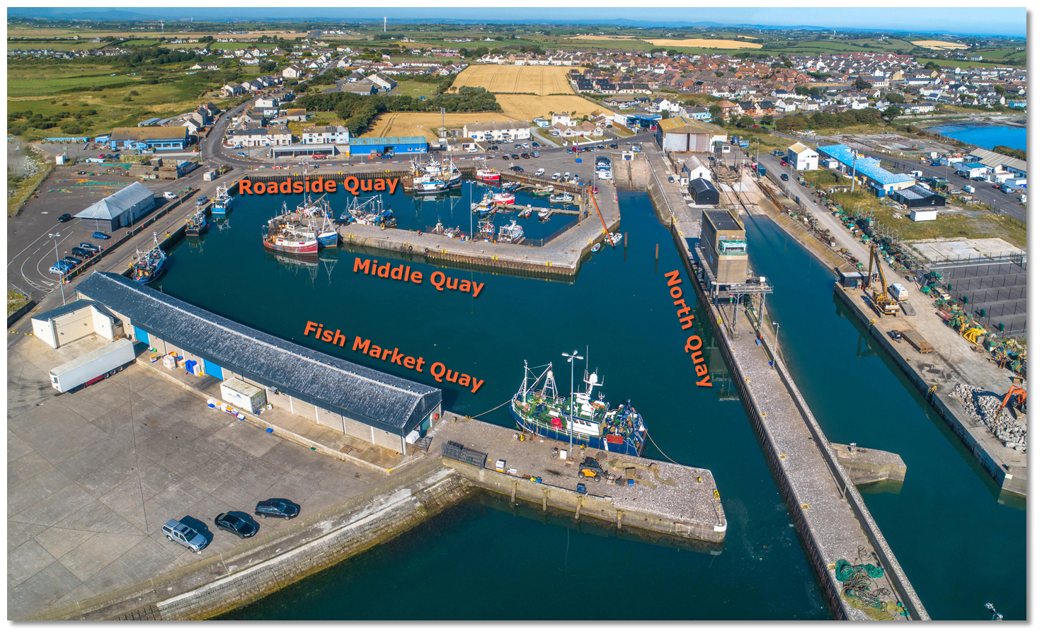
 Portavogie Harbour
Image: Michael Harpur
Portavogie Harbour is a small harbour with a town that lies 2 miles south of Burial Island. The modern harbour is formed by the enclosing arms of its two piers and the town has a population of about 2,200 and stands mainly on its north side. The harbour houses a large fishing fleet and it is an important and highly active commercial fishing port. The catch here is mainly prawns and herrings and there are fish auctions on the quays most evenings.
 Berthing will most likely be alongside the wall or fishing boat
Image: Michael Harpur
The port can accommodate vessels of up to 37 metres in length and 3 metres draft. In the past leisure craft have not been welcome but these days all mariners are welcome inside. However, expect the harbour to give priority to its fishing fleet for which the harbour is set up. Likewise, no provisions have been made to accommodate leisure craft so expect very 'rough and ready' rafting up here. Vessels will most likely be berthed alongside fishing boats or a rough quay wall so ample fenders if not a fender board should the only available berth be alongside a harbour wall with sheet piling.
 Portavogie Harbour is a busy commercial fishing port but it accepts leisure craft
Image: Michael Harpur
Owing to the level of fishing activity and space constrictions it is preferred that leisure craft consult the Harbour Master for advice in advance of an approach. Portavogie Harbour Master may be contacted by
 Ch. 14 [Portavogie Harbour],
  +44 28 4277 1470,
  +44 77 1207 4609 during normal working hours. These are Mon - Thur 8 am to 4.30 pm, Fri 8 am to 3.30 pm, Sat 8 am to 12 noon (Excludes Sundays and Statutory Holidays)
How to get in?
 Portavogie Harbour and the view southwards towards
the entrance to Strangford Lough
Image: Michael Harpur
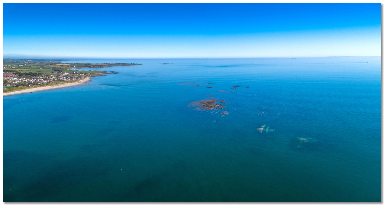
 Use the details available in the northeast Ireland’s Coastal Overview for Malin Head to Strangford Lough for local approaches. Standing off 3 miles from the shore during southern approaches, 1½ from the north clears all dangers. On closer approaches, rocks and drying shoals extend up to a ½ mile offshore, from the coast close north and south of the harbour.
 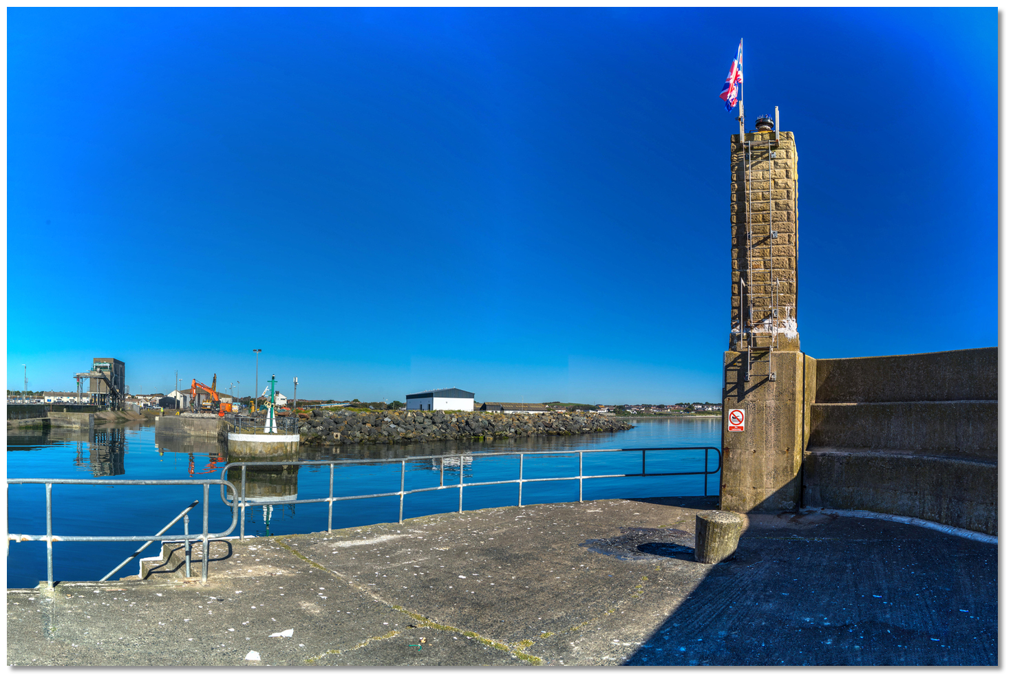 Brick tower with a sectored light on the Outer Breakwater
 Image: Michael Harpur
 The Portavogie Initial Fix is situated ¾ of a mile due east of the entrance where the harbour will be clearly visible. The lighted Plough Rock port buoy, Fl.R.3s, moored about a ½ mile east by southeast of the entrance will be seen close by. At night a 9-metre high sectored light is exhibited from a column situated on the extremity of the outer breakwater at Portavogie Harbour.
 Portavogie Harbour – Iso.W.R.G. 5s 9m 10-8M position: 54° 27.400´N, 005° 26.100´W
From the Initial Fix steer due west and directly for the north end of the outer breakwater through the rocky areas that lay offshore to the northeast and southwest of Portavogie. By night along the middle of the Portavogie Light’s white sector 258°- 275°, on the brick tower standing at the head of the outer breakwater.
 Selk Rock, McCammon Rocks and the Pillion to the northeast
Image: Michael Harpur
To the northeast, these reefs and rocks are, from north to south, Selk Rock (dries to 3 metres), McCammon Rocks (dries to 1.5 metres and part of which always shows) and the Pillion (dries to 3.4 metres), which are covered by the green sector, shore-to-258°.
 Bird Island and Green Island southward of Portavogie Harbour
Image: Michael Harpur
To the southeast, is the half-tide Plough Rock (dries to 3 metres) which is covered by the red sector 275° - 348° of the Portavogie Light. A shallow covered section with 0.6 extends 300 metres towards the entrance channel so it is not advisable for vessels approaching from the south to cut in from the south if Plough Rock is showing. Not to be mistaken for the always-showing Bird Island and Green Island, southward of Portavogie Harbour, Plough Rock and its rocky covered extension terminate a ½ mile northeast of the latter Green Island.
 Final approaches to Portavogie Harbour
Image: Michael Harpur
On final approaches, the path is narrowed by shallow areas of the approach path with 1.2 metres to the north, plus a section with 1.8 metres close south near the harbour entrance. Steering due west on the pierhead clears all these.
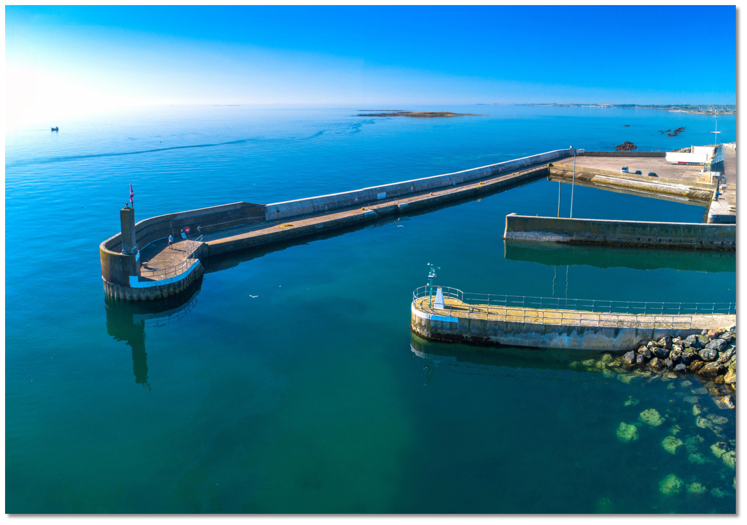 Portavogie Harbour's north facing entrance
Image: Michael Harpur
The final stretch outside the entrance is through a short 24-metre wide channel running out eastward of the harbour entrance. The entrance faces due north, with the brick tower standing on the southern outer breakwater's pierhead. The inner breakwater extending off the shoreline is lit at the entrance 2F.G(vert).
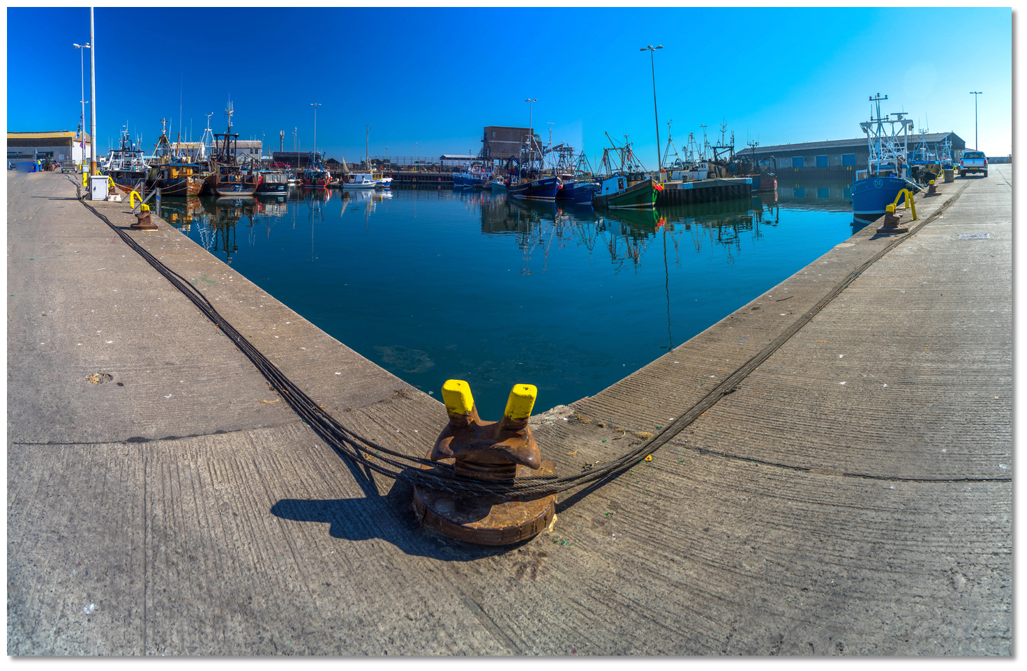
 Pathway to the Middle Basin and Inner Basin
Image: Michael Harpur
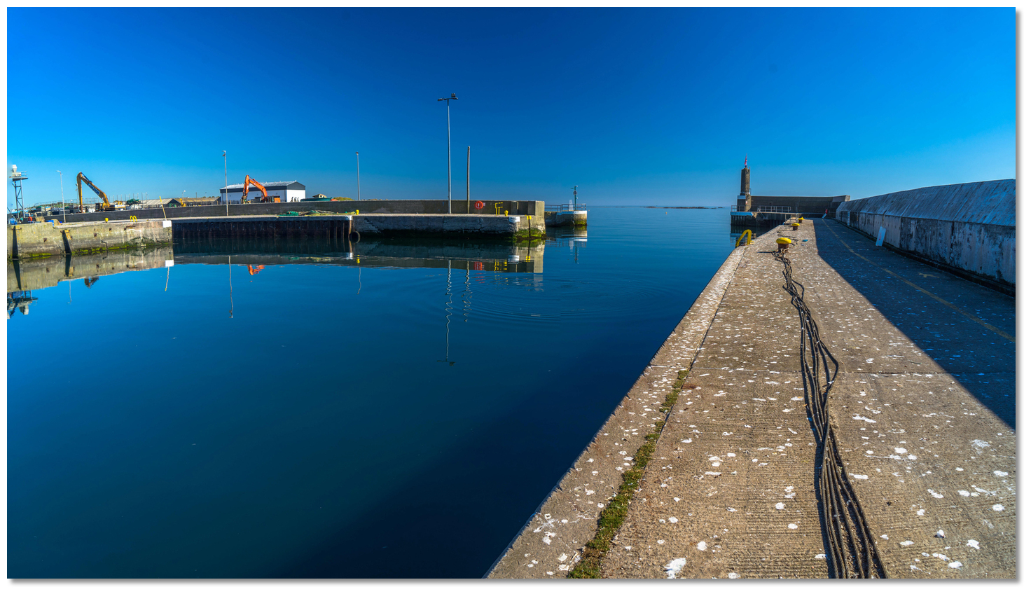
Once within the outer heads continue alongside the outer breakwater for about 40 metres then prepare to turn hard to starboard.
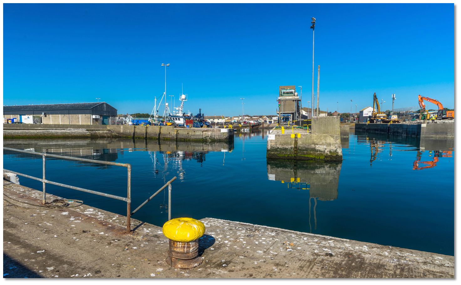 This entrance into the harbour’s basins
Image: Michael Harpur
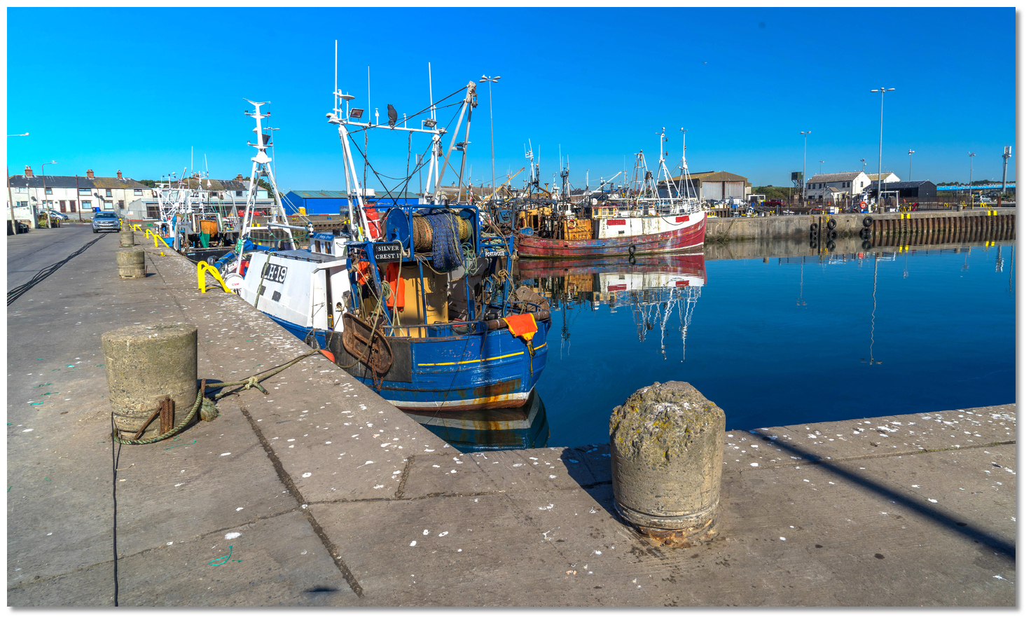
This is for the 10-metre-wide entrance to the main harbour’s Middle Basin and then the Inner Basin beyond. The harbour has a maintained depth of 3 metres throughout.
 Portavogie Harbour's Quays
Image: Michael Harpur
Berth as directed by the harbour master alongside the quays of the Middle Basin or Inner Basin.Why visit here?
Portavogie’s name is derived from its original Gaelic name 'Port a' Bhogaigh' meaning 'port or place of the boggy area'. The name evolved from its 1620 name of 'Portabogagh', to 'Portavaud' and finally, 'Portavogie' which was first recorded in 1810. 'Port' in Irish means either 'port' or 'place, spot, locality' and 'An Bogach' means 'the boggy area'.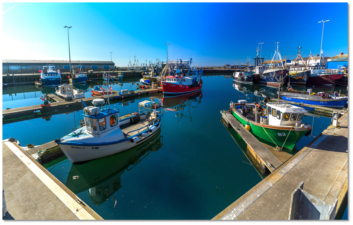 Despite having 'Port' in its name Portavogie was not historically a port
Image: Michael Harpur
Most unusually it is unlikely that the word 'Port' here is meant in the sense of a 'port' or 'harbour' as there is no evidence to suggest that an ancient landing place ever existed at Portavogie. The 1625 Clandeboye estate map, the earliest record of the townland, showed no sign of any harbour or beaching area that neighbouring Ballywalter and Ballyhalbert Bay have historically been used for. The 'bog' however certainly existed as the entire area of the Ards Peninsula, particularly the Blackstaff River delta, was historically an extensive bog.
 Portavogie is the second-largest fishing village in Ulster
Image: Michael Harpur
Portavogie's birth was born out of Scottish migration to northeaster Ireland that took off in the late 16th century and intensified in the early 17th century. This area, with the homeland in view on a clear day, saw large-scale migration. In 1606 Sir Hugh Montgomery and James Hamilton acquired the property in the Ards Peninsula to develop it as a private plantation. The first map of Portavogie, Hamilton's 1625 map drawn by Thomas Raven that is today on display in the 'North Down Heritage Centre in Bangor', showed rabbits drawn over the area close south of the town that was then described as a Warren.
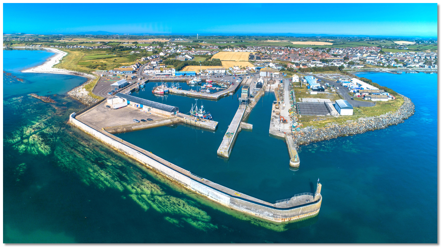
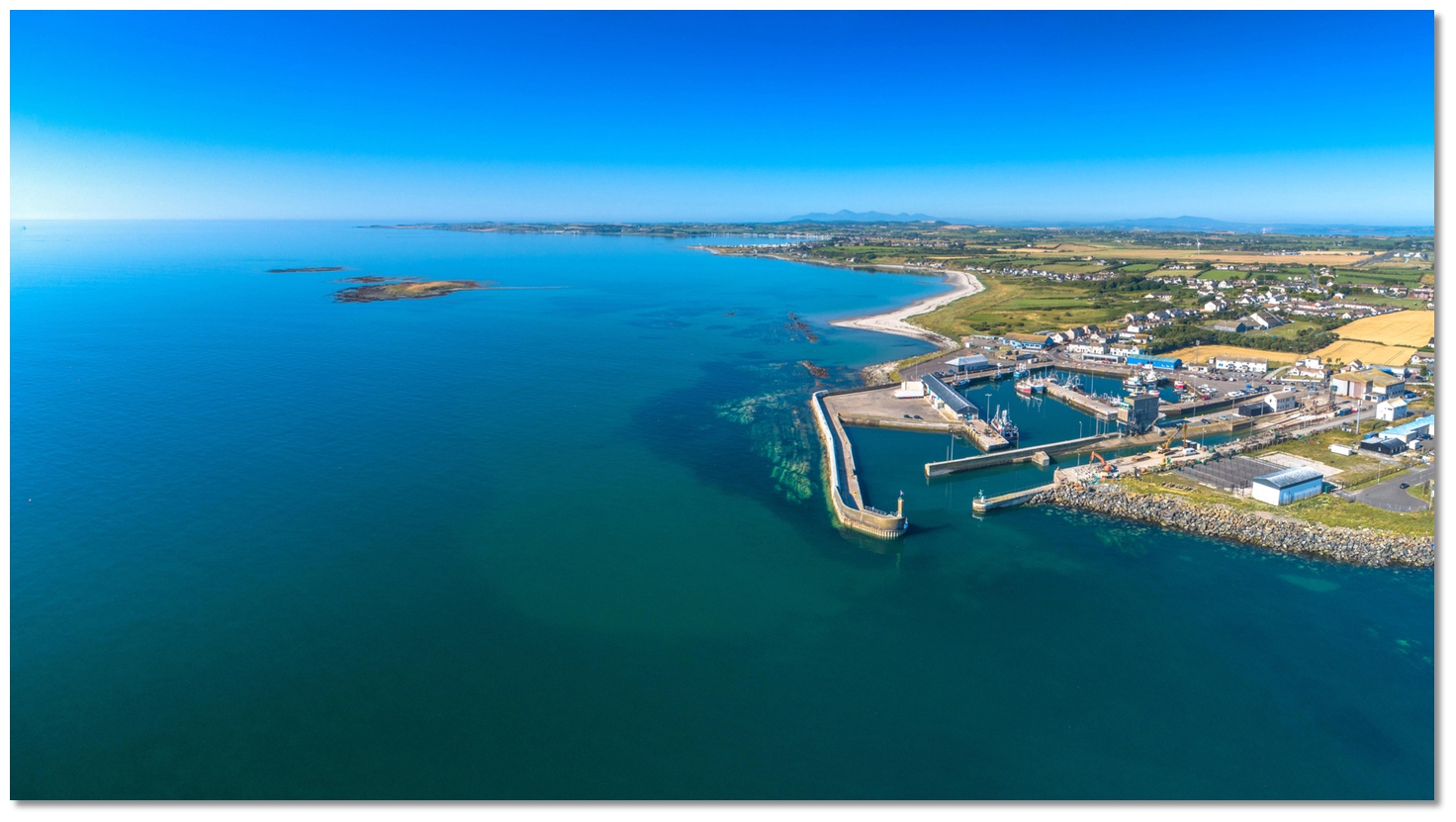
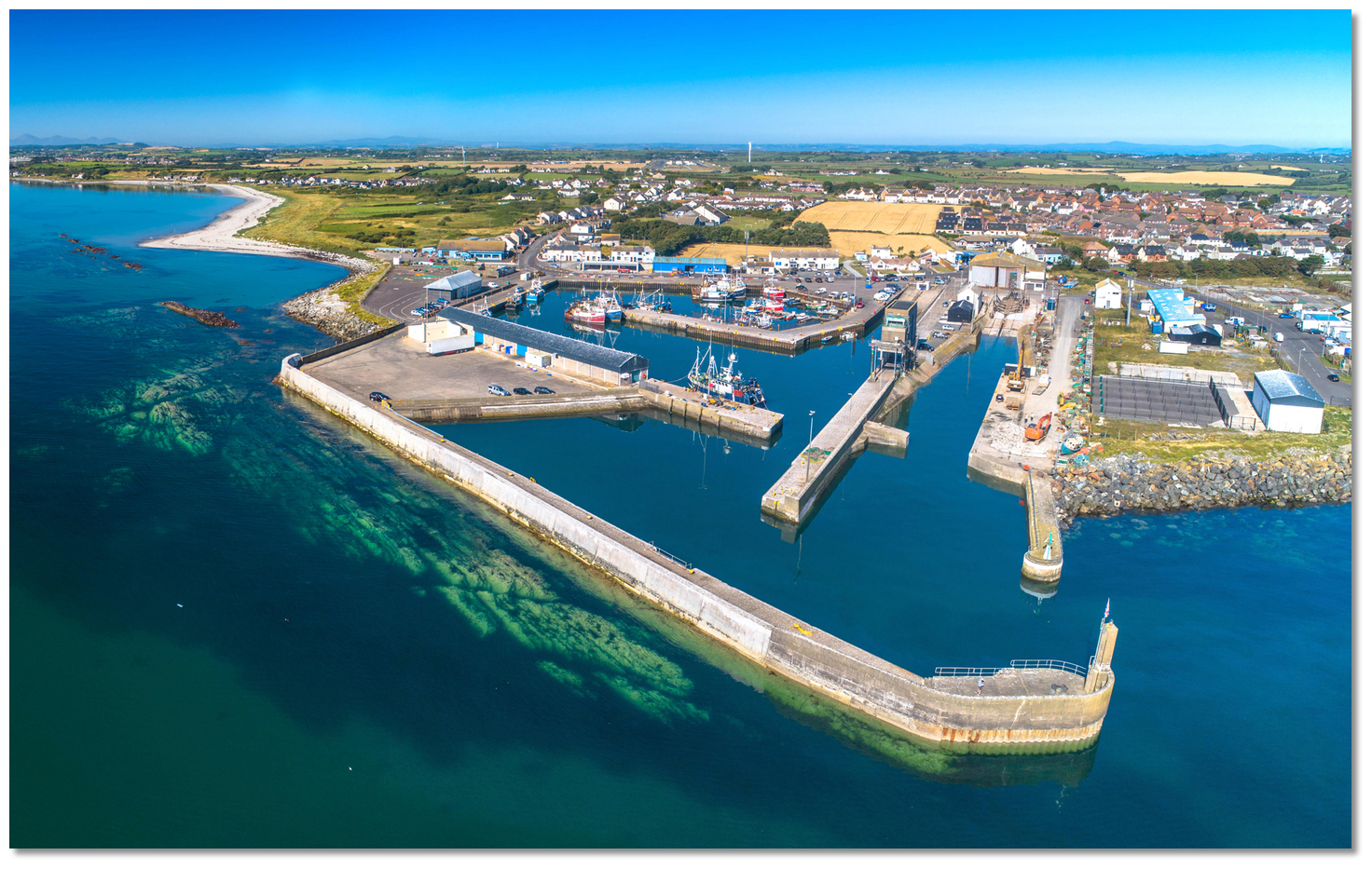
 The offshore reefs, breakwaters and entrance channel
 that making Portavogie Harbour a safe haven
Image: Michael Harpur
In 1735 the Anglo-Norman Echlin family were gifted the lands of the 'Savage family', by the crown as a reward for services rendered. The Savage family had held sway over the Ards since they arrived as part of the Norman invasion but at this point had come upon hard times. The Echlins were a powerful and industrious family who held lands in the Kingdom of Fife, Scotland, an area to the north of Edinburgh. They set about the task of draining the mid-Ards depression between Portavogie, Kirkistown and the Salt Water Bridge. Their contribution can be seen today in the quality of the fertile arable land of the 'Bogs' and the greater wealth this created was a primary impetus for the development of towns and ports on and around the peninsula.
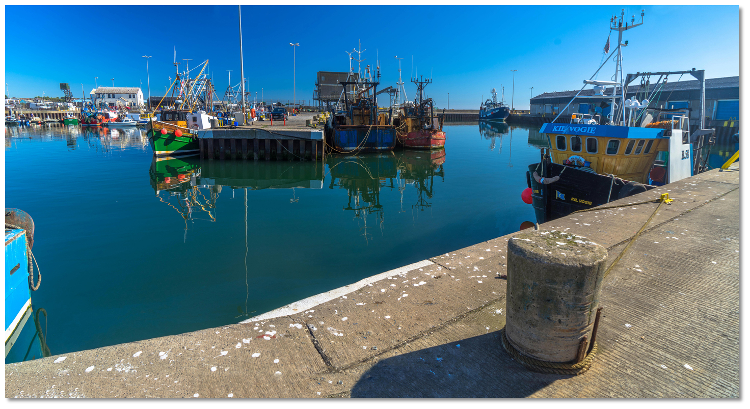
 Portavogie Harbour's protected Middle and Inner basins
Image: Michael Harpur
The village of Portavogie first appeared after the dredging, around 1750. It commenced with the arrival of a community of Scottish fishing families from Maidens in Ayrshire. They were 'Covenanters' who had come from Scotland to escape the persecution. A small harbour with an off-lying anchorage was hewed from the rocky landscape and a mainly Presbyterian village quickly developed around it. By 1900 there were 18 families associated with Portavogie and many of these lines have continued to this day.
 Portavogie Harbour seal looking for treats
Image: Allan LEONARD @MrUlster via CC BY-SA 3.0
Portavogie was to see its most significant change in the latter half of the 20th century when the harbour underwent major reconstruction work at the end of the 70s. New chambers and boat slips were built as well as a fish market and an ice plant. HRH Princess Anne visited the village to officially open the new harbour in 1985. The rebuilding of the harbour area transformed a 'pretty' safe anchorage into a modern, if slightly unappealing, industrial harbour.
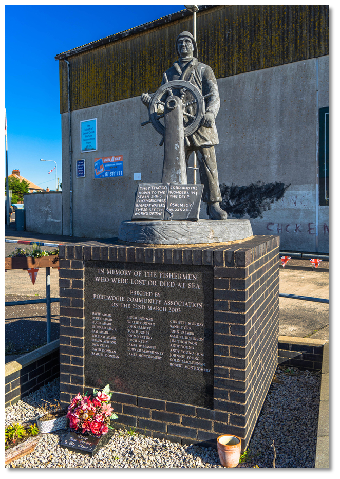 Portavogie's Memorial to its lost fishermen
Image: Michael Harpur
However, the fortunes are inextricably linked to the now declining fishing industry, declining fish stocks and ever-increasing fuel and operating costs combined to reduce the fishing fleets of Ireland and the UK. What remains unchanged however is the fishermen’s Ulster-Scots heritage. It is as clearly visible in the rising sun, which provides inspiring views of Scotland and the Isle of Man, as in their accents where one is 'yin', the night is pronounced 'nicht' and 'don't know' is clearly 'dinny noo'.
From a boating point of view, Portavogie is a useful drop-in harbour, albeit one for a vessel that comes well equipped with fenders and fender boards to protect them from a rough and ready industrial harbour. It offers quick and straightforward seaward access at any stage of the tide, night or day, and being just ten miles north of the Strangford Lough entrance it is a useful staging berth to time a favourable tide to enter the lough.
What facilities are available?
With a population of approximately 2000 people all basic provisions can be found at Portavogie. The area is geared to meet the needs of the fishing fleet. A boatyard where repairs to large fishing vessels may be undertaken is available and there is a ships' chandler. Supplies of diesel and fresh water are available at the wharfs, and there is a bus service to Newtownards.Any security concerns?
Portavogie is an open quay where normal security procedures should be adopted.With thanks to:
Michael Young - Harbour Master Kilkeel.Aerial views of Portavogie Harbour and surrounds
About Portavogie Harbour
Portavogie’s name is derived from its original Gaelic name 'Port a' Bhogaigh' meaning 'port or place of the boggy area'. The name evolved from its 1620 name of 'Portabogagh', to 'Portavaud' and finally, 'Portavogie' which was first recorded in 1810. 'Port' in Irish means either 'port' or 'place, spot, locality' and 'An Bogach' means 'the boggy area'.
Despite having 'Port' in its name Portavogie was not historically a portImage: Michael Harpur
Most unusually it is unlikely that the word 'Port' here is meant in the sense of a 'port' or 'harbour' as there is no evidence to suggest that an ancient landing place ever existed at Portavogie. The 1625 Clandeboye estate map, the earliest record of the townland, showed no sign of any harbour or beaching area that neighbouring Ballywalter and Ballyhalbert Bay have historically been used for. The 'bog' however certainly existed as the entire area of the Ards Peninsula, particularly the Blackstaff River delta, was historically an extensive bog.
Portavogie is the second-largest fishing village in UlsterImage: Michael Harpur
Portavogie's birth was born out of Scottish migration to northeaster Ireland that took off in the late 16th century and intensified in the early 17th century. This area, with the homeland in view on a clear day, saw large-scale migration. In 1606 Sir Hugh Montgomery and James Hamilton acquired the property in the Ards Peninsula to develop it as a private plantation. The first map of Portavogie, Hamilton's 1625 map drawn by Thomas Raven that is today on display in the 'North Down Heritage Centre in Bangor', showed rabbits drawn over the area close south of the town that was then described as a Warren.
The offshore reefs, breakwaters and entrance channel that making Portavogie Harbour a safe haven
Image: Michael Harpur
In 1735 the Anglo-Norman Echlin family were gifted the lands of the 'Savage family', by the crown as a reward for services rendered. The Savage family had held sway over the Ards since they arrived as part of the Norman invasion but at this point had come upon hard times. The Echlins were a powerful and industrious family who held lands in the Kingdom of Fife, Scotland, an area to the north of Edinburgh. They set about the task of draining the mid-Ards depression between Portavogie, Kirkistown and the Salt Water Bridge. Their contribution can be seen today in the quality of the fertile arable land of the 'Bogs' and the greater wealth this created was a primary impetus for the development of towns and ports on and around the peninsula.
Portavogie Harbour's protected Middle and Inner basinsImage: Michael Harpur
The village of Portavogie first appeared after the dredging, around 1750. It commenced with the arrival of a community of Scottish fishing families from Maidens in Ayrshire. They were 'Covenanters' who had come from Scotland to escape the persecution. A small harbour with an off-lying anchorage was hewed from the rocky landscape and a mainly Presbyterian village quickly developed around it. By 1900 there were 18 families associated with Portavogie and many of these lines have continued to this day.
Portavogie Harbour seal looking for treatsImage: Allan LEONARD @MrUlster via CC BY-SA 3.0
Portavogie was to see its most significant change in the latter half of the 20th century when the harbour underwent major reconstruction work at the end of the 70s. New chambers and boat slips were built as well as a fish market and an ice plant. HRH Princess Anne visited the village to officially open the new harbour in 1985. The rebuilding of the harbour area transformed a 'pretty' safe anchorage into a modern, if slightly unappealing, industrial harbour.
Portavogie's Memorial to its lost fishermenImage: Michael Harpur
However, the fortunes are inextricably linked to the now declining fishing industry, declining fish stocks and ever-increasing fuel and operating costs combined to reduce the fishing fleets of Ireland and the UK. What remains unchanged however is the fishermen’s Ulster-Scots heritage. It is as clearly visible in the rising sun, which provides inspiring views of Scotland and the Isle of Man, as in their accents where one is 'yin', the night is pronounced 'nicht' and 'don't know' is clearly 'dinny noo'.
From a boating point of view, Portavogie is a useful drop-in harbour, albeit one for a vessel that comes well equipped with fenders and fender boards to protect them from a rough and ready industrial harbour. It offers quick and straightforward seaward access at any stage of the tide, night or day, and being just ten miles north of the Strangford Lough entrance it is a useful staging berth to time a favourable tide to enter the lough.
Other options in this area
Click the 'Next' and 'Previous' buttons to progress through neighbouring havens in a coastal 'clockwise' or 'anti-clockwise' sequence. Alternatively here are the ten nearest havens available in picture view:
Coastal clockwise:
Portaferry - 3.8 miles SWBallyhenry Bay - 3.7 miles SW
Kircubbin - 2.5 miles WNW
Ballydorn and Down Cruising Club - 4.7 miles WNW
White Rock Bay - 4.4 miles WNW
Coastal anti-clockwise:
Ballyhalbert Bay - 1.4 miles NBallywalter - 3.1 miles NNW
Copelands Marina - 7.1 miles NNW
Donaghadee Harbour - 7.3 miles NNW
Chapel Bay - 8.3 miles NNW
Navigational pictures
These additional images feature in the 'How to get in' section of our detailed view for Portavogie Harbour.


| Detail view | Off |
| Picture view | On |
Aerial views of Portavogie Harbour and surrounds
Add your review or comment:
Please log in to leave a review of this haven.
Please note eOceanic makes no guarantee of the validity of this information, we have not visited this haven and do not have first-hand experience to qualify the data. Although the contributors are vetted by peer review as practised authorities, they are in no way, whatsoever, responsible for the accuracy of their contributions. It is essential that you thoroughly check the accuracy and suitability for your vessel of any waypoints offered in any context plus the precision of your GPS. Any data provided on this page is entirely used at your own risk and you must read our legal page if you view data on this site. Free to use sea charts courtesy of Navionics.