
Audley Roads is located on the northeast coast of Ireland, on the western shore and at the head of The Narrows that lead to Strangford Lough. It offers a picturesque anchorage in a quiet bay adjacent to Strangford Harbour.
Audley Roads provides a good anchorage out of the main tidal stream. It is somewhat exposed to the south with its wide open bay, lowlands and a funnelling river bed. As such, with southerly quadrant winds of force five and above the anchorage has an uncomfortable fetch. Access is straightforward once The Narrows have been navigated as it is effectively within the enclosed stretch of water that is the Lough. This provides shelter sailing in all weather, all tides and has ample marks to make daylight navigation straightforward.

Keyfacts for Audley's Roads


Last modified
November 7th 2022 Summary* Restrictions apply
A good location with careful navigation required for access.Facilities


Nature


Considerations


 +44 28 4488 1774
 secretary@strangfordsailingclub.com
 strangfordsailingclub.com/
Position and approaches

Expand to new tab or fullscreen
Haven position
 54° 22.682' N, 005° 34.119' W
Upon the five metre contour in the middle of the marked small craft anchoring area. It is in the approximate midpoint between the small stone pier, under the ruins of Audley Castle, and the pole marking Sleuth Rocks at the southeast most point of the anchorage.
What is the initial fix?
The following Strangford Lough Initial Fix will set up a final approach:
 54° 18.226' N, 005° 29.492' W


What are the key points of the approach?
Offshore details for vessels approaching Strangford Lough from the north are available in northeast Ireland’s coastal overview for Malin Head to Strangford Lough  . Details for vessels approaching from the south are available in eastern Ireland’s coastal overview for Strangford Lough to Dublin Bay . Details of the approaches, tidal timings, the run up The Narrows and onward to Killyleagh, on the Lough's western shore, are covered in the Entering and exiting Strangford Lough route description.
. Details for vessels approaching from the south are available in eastern Ireland’s coastal overview for Strangford Lough to Dublin Bay . Details of the approaches, tidal timings, the run up The Narrows and onward to Killyleagh, on the Lough's western shore, are covered in the Entering and exiting Strangford Lough route description.Not what you need?
Click the 'Next' and 'Previous' buttons to progress through neighbouring havens in a coastal 'clockwise' or 'anti-clockwise' sequence. Below are the ten nearest havens to Audley's Roads for your convenience.
Ten nearest havens by straight line charted distance and bearing:
- Audley’s Point - 0.5 nautical miles NW
- Strangford Harbour (Strangford Village) - 0.6 nautical miles ESE
- Ballyhenry Bay - 0.7 nautical miles NNE
- Portaferry - 0.7 nautical miles E
- Chapel Island - 1 nautical miles WNW
- Between Jackdaw & Chapel Island - 1.2 nautical miles WNW
- Jackdaw Island - 1.4 nautical miles W
- Cross Roads - 1.9 nautical miles SSE
- Don O’Neill Island - 2.6 nautical miles NW
- Salt Island (South) - 2.6 nautical miles W
These havens are ordered by straight line charted distance and bearing, and can be reordered by compass direction or coastal sequence:
- Audley’s Point - 0.5 miles NW
- Strangford Harbour (Strangford Village) - 0.6 miles ESE
- Ballyhenry Bay - 0.7 miles NNE
- Portaferry - 0.7 miles E
- Chapel Island - 1 miles WNW
- Between Jackdaw & Chapel Island - 1.2 miles WNW
- Jackdaw Island - 1.4 miles W
- Cross Roads - 1.9 miles SSE
- Don O’Neill Island - 2.6 miles NW
- Salt Island (South) - 2.6 miles W


What's the story here?
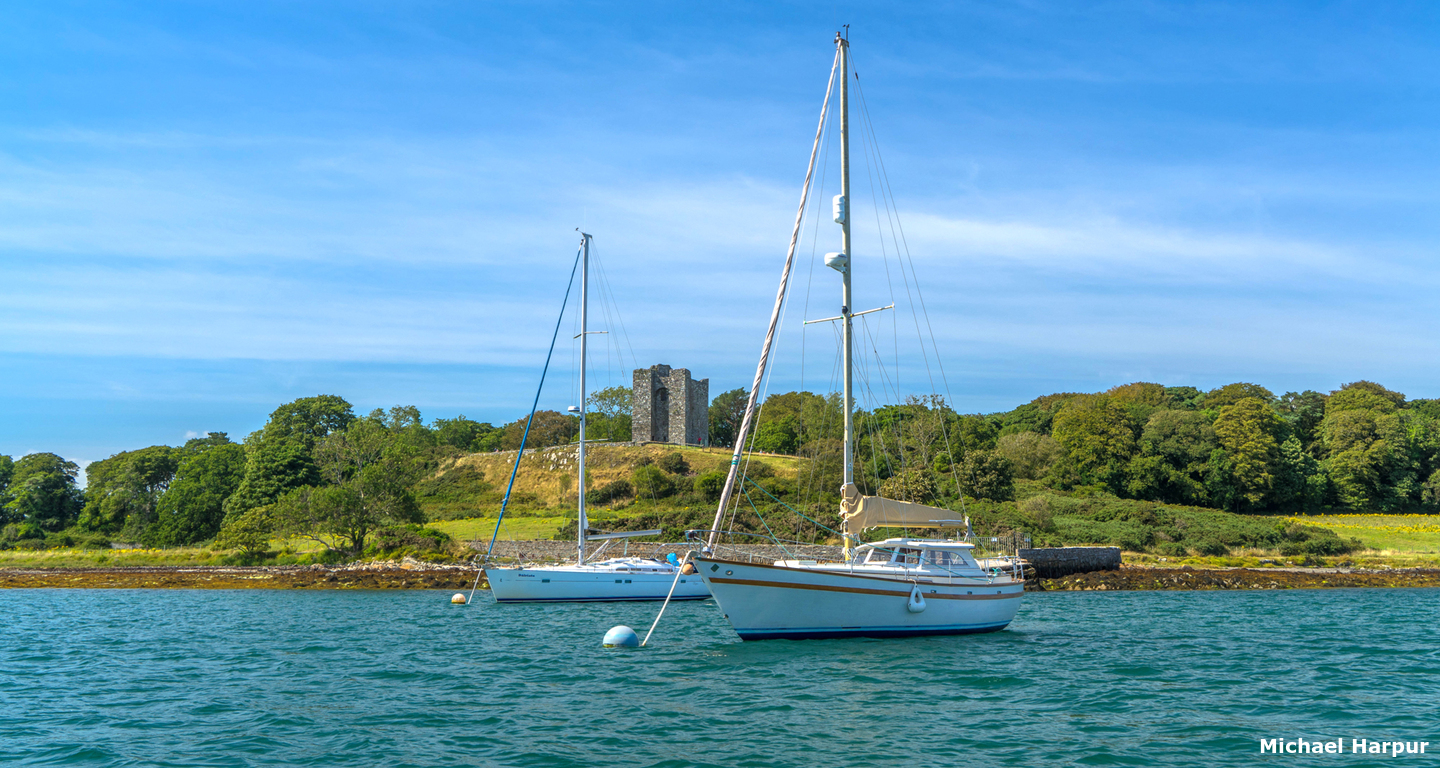
 Audley's Castle overlooking Audley's Roads
Image: Michael Harpur
Audley's Roads is situated on the west shore of The Narrows ⅔ of a mile north of Strangford Harbour. It is entered between Church Point and Audley's Point and the anchorage is in the north end of Strangford Bay also known as Castleward Bay. It is overlooked from a rocky height by the magnificent 15th-century Audley's Castle a three-storey tower house.
 Strangford Bay also known as Castleward Bay
Image: Michael Harpur
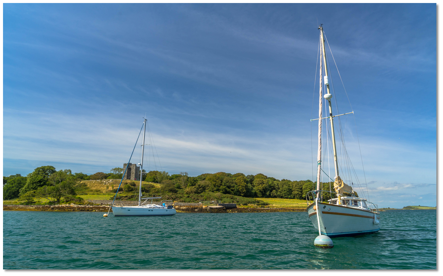
Audley's Roads provides an excellent anchorage for leisure craft with good holding ground out of
the tidal currents. At weekends in the summer, or during race days, it may be busy with local boats. However, there is plenty of room if you are prepared to anchor in depths of up to 10 metres when the area is busy. Strangford Sailing Club moorings are also located in Audley’s Roads and they allow visitors to use them.
 Strangford Sailing Club boats on their moorings
Image: Michael Harpur
The bay and moorings are well sheltered from all wind except strong southerlies. However, this presents little issue here as there is a choice of perfectly sheltered berths from these conditions less than 10 minutes away either around Church Point or Audley's Point.
How to get in?
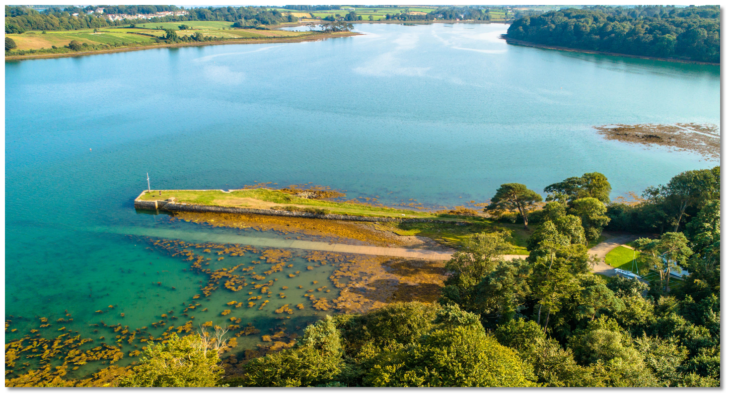
_on_the_western_shore_and_at_the_head_of_the_narrows.jpg) Strangford Bay (Castleward Bay) on the western shore and at the head of The
Strangford Bay (Castleward Bay) on the western shore and at the head of TheNarrows
Image: Michael Harpur
 Details of the approaches, tidal timings, the run up The Narrows and onward to Killyleagh, on the Lough's western shore, are covered in the Entering and exiting Strangford Lough route description.
Image: Michael Harpur
Vessels entering Audley's Road from southward should take care not to round Church Point too closely. There is a rock awash 60 metres eastward of the pyramidic Church Point Beacon. Furter along there is Zara Shoal that encroaches into the head of the bay.
.jpg) The Special Marker Buoy with Church Point in the backdrop (right)
The Special Marker Buoy with Church Point in the backdrop (right)Image: Michael Harpur
It is a rocky shelf with 0.6 metres of cover over it in places that extends 300 metres northward off the inner side of the point. Keeping 100 metres northward of a line of the Church Point Beacon and the Special Marker Buoy in the bay will clear Zara Shoal.
 Anchor outside of the moorings
 Image: Michael Harpur
The recommended berthing area is to the south of the club starting area, which is a line between Audley’s Quay (also called Portahougha Quay), a small historic stone pier under the Castle, and Church Point. Do not drift too far southeastward as Sleuth Rocks, marked by a pole and drying to 2.7 metres, extend out 300 metres into the southeast side of the bay..jpg) The moorings extending from Audley’s Quay (charted as Portahougha Quay)
The moorings extending from Audley’s Quay (charted as Portahougha Quay)Image: Michael Harpur
The bay provides good holding ground with a sand/mud bottom for anchoring but can be subject to kelp over boulders that may foul a CQR. Hence an anchor watch is advisable and the vessel should not be left unattended until the security of the holding has been assured.
 Strangford Sailing Club allow visitors to pick up their moorings
Image: Michael Harpur
Strangford Sailing Club does not have any designated visitor moorings but they allow visitors to use vacant club moorings for a short stay at your own risk.
 Old stone pier and slip belonging to Strangford Sailing Club
Image: Michael Harpur
If a mooring is borrowed, and you are leaving your boat with no one onboard, please leave a visible note so that the owner of the mooring can contact you on their return.

 The slip and old stone pier belonging to Strangford Sailing Club
Image: Michael Harpur
Land by dinghy at the Strangford Sailing Club quay extending from the western shore. The old stone quay had a slip on its northern side that is available at all stages of the tide. It is also possible to land at the old quay beneath Audley's Castle that always has water alongside.
Why visit here?
Audley Roads takes its name from Audley’s Castle, the landmark 15th-century tower house that stands with commanding views over the anchorage and The Narrows. The historic family name is widely used in the surrounding area such as in Audley’s Woods, Audleystown Farm, one of the three farms in the townland, Audleystown Townland itself and in nearby Downpatrick one of the electoral wards is called Audley’s Acre. The Audleys date back to the Anglo-Normand invasion of Ulster.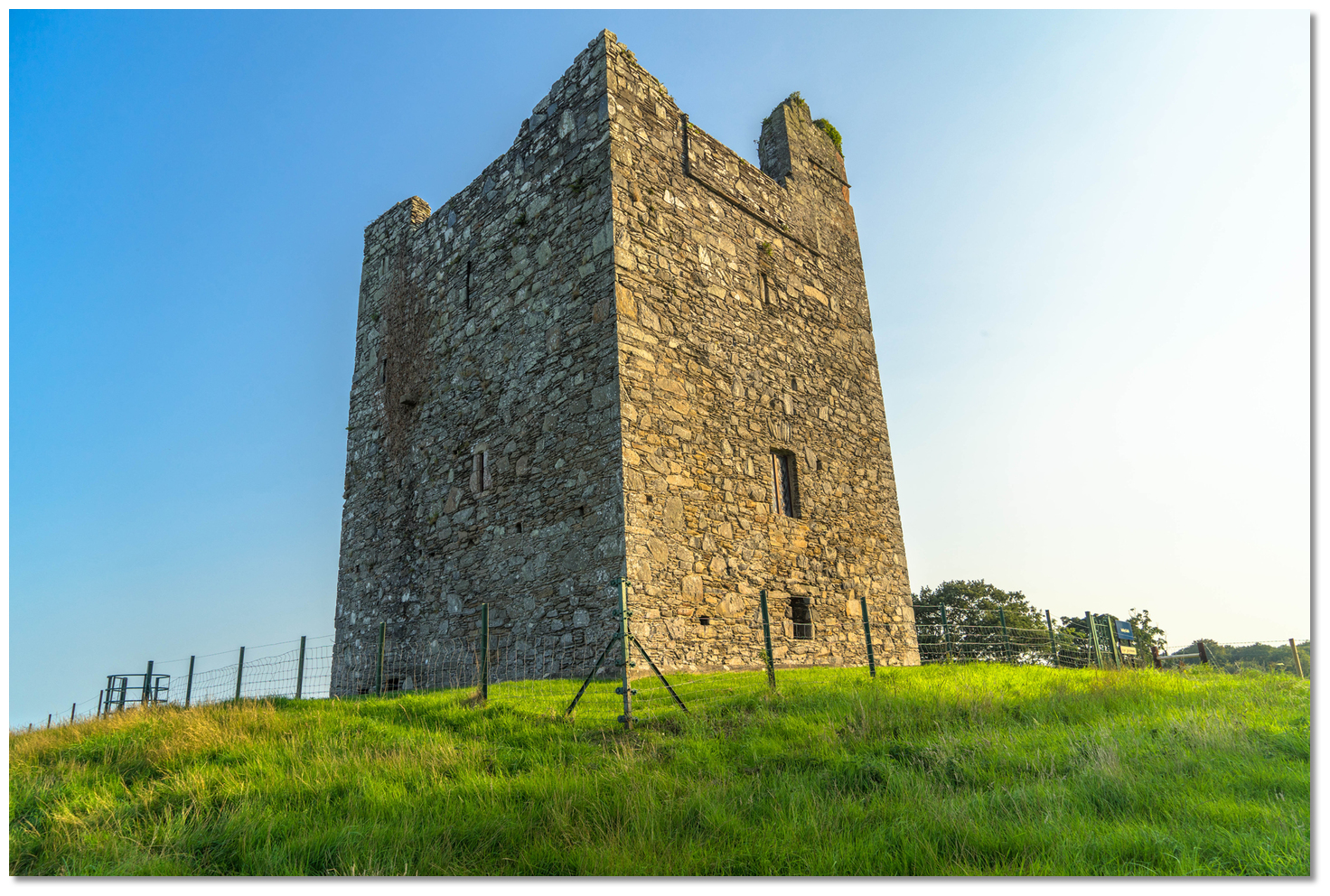 Audley's Castle
Image: Michael Harpur
De Courcy, the leader of the invasion, appears to have come from the south of England. It was from this region he collected a number of his companions for the Ulster invasion and amongst these were the notable family names of Audleys and the Savages which come from counties, Cheshire and Derbyshire.
 View over the anchorage from the foot of Audley's Tower
Image: Michael Harpur
All the four sons of Adam d’Audley seem to have come over to Ireland and it is noted in the Calendar of Documents Relating to Ireland at that date, "Honour of Chester: Bertram de Verdun. Adam de Audeley for him renders his account for the passage of John de Courci into Ireland". The Savage family settled in the Ards Peninsula making their base in the small 16th-century tower house, Portaferry Castle, from which, together with the tower house in Strangford, they controlled sea traffic through the Narrows. They established themselves as the senior family of the English interest in the region.
 The commanding view Audley's Castle offers
Image: Michael Harpur
By comparison, the Audleys do not seem to have played a particularly conspicuous part in Ulster's history. Evidence shows that the first fortification on the crest was a wooden castle with a motte. It was one of the 27 fortresses founded by Courcy to hold his lands. The picturesque tower house seen today was built by the Audley family in the 15th century (circa 1420-1450) and was modelled on the nearby Kilclief Castle. It had at that time a 2.7 metres high bawn wall (courtyard) around the castle with itself being in one corner of this enclosed bawn. The lowest couple of feet of this wall still exists and there is also a remnant of an outhouse.
 The original tower would have been higher
Image: Michael Harpur
The family had outgrown the tower house by the 17th century and a two-storey house was added to the east side of the tower house - the wall scars of this structure are still visible on the side today. The family remained in possession of their Castle and a portion of their estates up until 1646 when the castle was bought by the adjacent Ward family. Local tradition has it that the last Audley married one of his tenants and it was said they "lived no better than them". There is an account from 1899 that an Audley-Savage died unmarried in a little one-storey cottage on the hillside at Audleystown and it is believed to be the last of the Audley male line.
 The Ward tower house
Image: Michael Harpur
The wards arrived here from the 1580s to 1590s onwards and their arrival represented the rise of one family and the decline of another. The Wards, subsequently Lords Bangor, lived in the adjacent Castle Ward, also still standing intact in the Castle Ward farmyard, which was built about 1600 with defence rather than comfort in mind. Early in the 18th century when times were more peaceful, and obviously the Wards more affluent, a house in the Queen Anne style was built near the Old Castle. This house was demolished in the mid-19th century as there was much grander accommodation at this time.
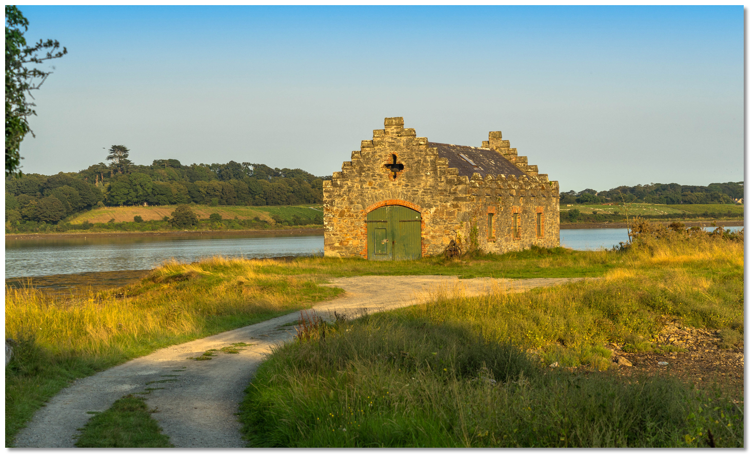
 The old boat house in the bay with the mansion in the backdrop
Image: Michael Harpur
This was the present mid-Georgian mansion called Castle Ward House was built in the middle of the pre-existing demesne from c.1761-7. Then, Bernard Ward, Viscount Bangor used Audley’s Castle as a focal point at the end of their lake to accentuate the large mansions with sweeping views down the bay to the Narrows. His investment in perfecting his country estate to keep up with the latest Georgian era aristocratic fashions. But Bernard Ward often had to retreat from his personal view of perfection much of the time as he and his wife Lady Anne famously argue about everything.
 Visitors experiencing the Castle Ward Tour
Image: Michael Harpur
This can be seen today in the design of their beautifully sited 18th-century mansion. They seemed to resolve their disputes by drawing lines and getting their way on either side of the demarcations. His choice, Classical Palladian, can be seen at the front, while her favourite Gothic style influences the rear garden façade overlooking Strangford Lough. Likewise, interiors are a quirky mix of distinctly different styles of classical Palladian and Gothic fantasy. This can be seen in his white-and-beige Music Room which is picked out in exquisite plasterwork, while her Boudoir has an undulating fan-vaulted ceiling that conjures up the medievalism of King Henry VII’s chapel at Westminster. Sadly they did not manage to enjoy the fruits of their efforts as Lord and Lady Bangor subsequently divorced perhaps because of the strain caused by the build. But this difference in aesthetics would pale into significance when set against the misfortune it would bring to the people of Audleystown in the following century.
 The front of the Castle Ward Mansion
Image: Michael Harpur
When the 3rd Viscount Bangor died in 1837 his widow, Harriet, married Major Andrew Savage-Nugent four years later in 1841. Savage owned an estate on the western shore of Strangford Lough directly opposite Castle Ward. It appears Lady Bangor had a stern reputation and was known as 'The Evictor'. She was unhappy with the view across from Castle Ward House as it passed over the village of Audleystown situated a little north of Audley's castle even though the Lough does separate them at a narrow point. Nevertheless, it was felt it spoiled the 'naturalistic' panoramas across his parkland from the mansion. If on the other hand it was replaced by woodland then both the Castle Ward and Nugent Estate would appear to blend into one. Major Andrew Savage-Nugent had no qualms with this perspective as he did not like the inhabitants of the village. They were very poor and not the sort he wanted as neighbours to his property.
 The old boat house on Dickson's Island a small peninsula projecting into
Castleward Bay
Image: Michael Harpur
So the village was cleared, their buildings demolished and completely removed. The tenants of the small settlement were reportedly shipped off to America and the Bangors planted the more aesthetically pleasing Audley’s Woods over the fields; the Mountain Wood (c.1844) and Windmill Plantation (c.1850). The stones from the smashed village were then used to build some of the walls surrounding Castle Ward Estate. There is ample evidence to support this. Local memory in the neighbouring village of Strangford recalls how many of the villagers baked soda and wheaten bread for the people to take on the voyage. The American Folk Park archive has a rent book from Castleward where it appears that 25 families consisting of approximately 197 people were deported from Audleystown on 28th October 1852 on a ship called Ros. However there is no record of them ever arriving in the United States. The ship could have been lost or they may have gone to Canada or Mexico. Whatever happened to these people remains a mystery but whatever the case the village of Audleystown disappeared off the map. Literally, the O.S. maps record the transition with the map of 1835 showing the village at Audleystown, behind Audley's Castle, and in the subsequent map, of 1863, it is gone. All that remains today are the woods and pastoral lands.
 View from the Strangford Sailing Club quay
Image: Michael Harpur
All of this drive for beauty has left a legacy is now a gift to the nation. Castle Ward is one of Ireland’s finest demesnes or country estates, and all the Castle Ward structures, Castle Ward Mansion, Audley’s Castle, Castle Ward, a Neoclassical temple, as well as the winding trails through Audley’s Woods the parklands and the area along the lough shoreline are all owned by the National Trust and open to visiting boaters. It is simply an 820-acre treasure chest to stroll out and entirely enjoy. Amidst this wonderful estate is the welcome Strangford Sailing Club. Visitors are welcome to use showers when the clubhouse is open or by prior arrangement with the Hon Sec.
 Strangford Sailing Club clubhouse in the Castle Ward Estate grounds
Image: Michael Harpur
The Strangford Sailing Club quay and/or slip offers all tide tender landings on the western shore is the perfect point to commence a pleasant walk through the estate's woodland trails and Castle Ward. It is also possible to land at Audley's Quay, in the shadow of the 15th-century castle, at all stages of the tide. It was favoured by Maxwell Ward, the 6th Viscount, as its deepwater location allowed him to moor his boat, Bonito, at low tide.
 Audley's Quay beneath the castle
Image: Michael Harpur
Audley's Castle above is a must-visit which affords excellent views of the Narrows and the towns of Portaferry and Strangford. Castle Ward features WCs, a tea room, shop, adventure playground, a Wildlife Centre and a Victorian Past heritage centre. The Barn has excellent audio-visual displays and videos of marine wildlife, particularly the bird and mammal life found at the Lough. It is worth the visit to take in Viscount Bangor’s superb views across the waters of the Lough and to take in what this family had to enjoy.
 Castle Ward and the farmyard is the Stark stronghold, Winterfell
Image: Tourism Ireland
Those who want to tread the same grounds as the Family Stark from the series Game of Thrones will be in their element here. Audley’s Castle and Woods were the locations for the Stark family’s war encampment in Season One. It also appeared as a backdrop to the Twins', Frey residence in the 'Red wedding' in season 3, episode 9. The 1760s-built Castle Ward and the farmyard of the mansion is the Stark stronghold, Winterfell.
 Audley's Roads is a simply perfect coastal cruising anchorage
Image: Michael Harpur
From a boating point of view, the deepwater anchorage below the castle has been a traditional boating haven from the tides of Strangford Lough Narrows throughout the centuries. This it remains but with the gift of Castleward Estate parkland, set into the already very beautiful quiet rural area of small fields and low hills, it is one of the most perfect berths a vessel being up in and come ashore to visit.
What facilities are available?
Showers available on race days at Strangford Sailing Club and a boat slip with fresh water is available at Audley’s pier. Nearby Strangford Harbour has basic provisions plus pubs and restaurants that you would expect with a population of approximately 500. A bus service runs from Strangford Harbour to the larger town of Downpatrick that serves as a commercial and administrative centre for the locality. The nearest international airport is at Belfast 56 km. Portaferry, on the Ards Peninsula, is available by a car ferry service that runs every half hour (weather permitting) from Strangford Harbour.Any security concerns?
Never a problem known to have occurred at Audley Roads.With thanks to:
Brian Crawford, local Strangford Lough boatman of many decades.An aerial overview of Audley's Castle
About Audley's Roads
Audley Roads takes its name from Audley’s Castle, the landmark 15th-century tower house that stands with commanding views over the anchorage and The Narrows. The historic family name is widely used in the surrounding area such as in Audley’s Woods, Audleystown Farm, one of the three farms in the townland, Audleystown Townland itself and in nearby Downpatrick one of the electoral wards is called Audley’s Acre. The Audleys date back to the Anglo-Normand invasion of Ulster.
Audley's CastleImage: Michael Harpur
De Courcy, the leader of the invasion, appears to have come from the south of England. It was from this region he collected a number of his companions for the Ulster invasion and amongst these were the notable family names of Audleys and the Savages which come from counties, Cheshire and Derbyshire.
View over the anchorage from the foot of Audley's TowerImage: Michael Harpur
All the four sons of Adam d’Audley seem to have come over to Ireland and it is noted in the Calendar of Documents Relating to Ireland at that date, "Honour of Chester: Bertram de Verdun. Adam de Audeley for him renders his account for the passage of John de Courci into Ireland". The Savage family settled in the Ards Peninsula making their base in the small 16th-century tower house, Portaferry Castle, from which, together with the tower house in Strangford, they controlled sea traffic through the Narrows. They established themselves as the senior family of the English interest in the region.
The commanding view Audley's Castle offersImage: Michael Harpur
By comparison, the Audleys do not seem to have played a particularly conspicuous part in Ulster's history. Evidence shows that the first fortification on the crest was a wooden castle with a motte. It was one of the 27 fortresses founded by Courcy to hold his lands. The picturesque tower house seen today was built by the Audley family in the 15th century (circa 1420-1450) and was modelled on the nearby Kilclief Castle. It had at that time a 2.7 metres high bawn wall (courtyard) around the castle with itself being in one corner of this enclosed bawn. The lowest couple of feet of this wall still exists and there is also a remnant of an outhouse.
The original tower would have been higherImage: Michael Harpur
The family had outgrown the tower house by the 17th century and a two-storey house was added to the east side of the tower house - the wall scars of this structure are still visible on the side today. The family remained in possession of their Castle and a portion of their estates up until 1646 when the castle was bought by the adjacent Ward family. Local tradition has it that the last Audley married one of his tenants and it was said they "lived no better than them". There is an account from 1899 that an Audley-Savage died unmarried in a little one-storey cottage on the hillside at Audleystown and it is believed to be the last of the Audley male line.
The Ward tower houseImage: Michael Harpur
The wards arrived here from the 1580s to 1590s onwards and their arrival represented the rise of one family and the decline of another. The Wards, subsequently Lords Bangor, lived in the adjacent Castle Ward, also still standing intact in the Castle Ward farmyard, which was built about 1600 with defence rather than comfort in mind. Early in the 18th century when times were more peaceful, and obviously the Wards more affluent, a house in the Queen Anne style was built near the Old Castle. This house was demolished in the mid-19th century as there was much grander accommodation at this time.
The old boat house in the bay with the mansion in the backdropImage: Michael Harpur
This was the present mid-Georgian mansion called Castle Ward House was built in the middle of the pre-existing demesne from c.1761-7. Then, Bernard Ward, Viscount Bangor used Audley’s Castle as a focal point at the end of their lake to accentuate the large mansions with sweeping views down the bay to the Narrows. His investment in perfecting his country estate to keep up with the latest Georgian era aristocratic fashions. But Bernard Ward often had to retreat from his personal view of perfection much of the time as he and his wife Lady Anne famously argue about everything.
Visitors experiencing the Castle Ward TourImage: Michael Harpur
This can be seen today in the design of their beautifully sited 18th-century mansion. They seemed to resolve their disputes by drawing lines and getting their way on either side of the demarcations. His choice, Classical Palladian, can be seen at the front, while her favourite Gothic style influences the rear garden façade overlooking Strangford Lough. Likewise, interiors are a quirky mix of distinctly different styles of classical Palladian and Gothic fantasy. This can be seen in his white-and-beige Music Room which is picked out in exquisite plasterwork, while her Boudoir has an undulating fan-vaulted ceiling that conjures up the medievalism of King Henry VII’s chapel at Westminster. Sadly they did not manage to enjoy the fruits of their efforts as Lord and Lady Bangor subsequently divorced perhaps because of the strain caused by the build. But this difference in aesthetics would pale into significance when set against the misfortune it would bring to the people of Audleystown in the following century.
The front of the Castle Ward MansionImage: Michael Harpur
When the 3rd Viscount Bangor died in 1837 his widow, Harriet, married Major Andrew Savage-Nugent four years later in 1841. Savage owned an estate on the western shore of Strangford Lough directly opposite Castle Ward. It appears Lady Bangor had a stern reputation and was known as 'The Evictor'. She was unhappy with the view across from Castle Ward House as it passed over the village of Audleystown situated a little north of Audley's castle even though the Lough does separate them at a narrow point. Nevertheless, it was felt it spoiled the 'naturalistic' panoramas across his parkland from the mansion. If on the other hand it was replaced by woodland then both the Castle Ward and Nugent Estate would appear to blend into one. Major Andrew Savage-Nugent had no qualms with this perspective as he did not like the inhabitants of the village. They were very poor and not the sort he wanted as neighbours to his property.
The old boat house on Dickson's Island a small peninsula projecting intoCastleward Bay
Image: Michael Harpur
So the village was cleared, their buildings demolished and completely removed. The tenants of the small settlement were reportedly shipped off to America and the Bangors planted the more aesthetically pleasing Audley’s Woods over the fields; the Mountain Wood (c.1844) and Windmill Plantation (c.1850). The stones from the smashed village were then used to build some of the walls surrounding Castle Ward Estate. There is ample evidence to support this. Local memory in the neighbouring village of Strangford recalls how many of the villagers baked soda and wheaten bread for the people to take on the voyage. The American Folk Park archive has a rent book from Castleward where it appears that 25 families consisting of approximately 197 people were deported from Audleystown on 28th October 1852 on a ship called Ros. However there is no record of them ever arriving in the United States. The ship could have been lost or they may have gone to Canada or Mexico. Whatever happened to these people remains a mystery but whatever the case the village of Audleystown disappeared off the map. Literally, the O.S. maps record the transition with the map of 1835 showing the village at Audleystown, behind Audley's Castle, and in the subsequent map, of 1863, it is gone. All that remains today are the woods and pastoral lands.
View from the Strangford Sailing Club quayImage: Michael Harpur
All of this drive for beauty has left a legacy is now a gift to the nation. Castle Ward is one of Ireland’s finest demesnes or country estates, and all the Castle Ward structures, Castle Ward Mansion, Audley’s Castle, Castle Ward, a Neoclassical temple, as well as the winding trails through Audley’s Woods the parklands and the area along the lough shoreline are all owned by the National Trust and open to visiting boaters. It is simply an 820-acre treasure chest to stroll out and entirely enjoy. Amidst this wonderful estate is the welcome Strangford Sailing Club. Visitors are welcome to use showers when the clubhouse is open or by prior arrangement with the Hon Sec.
Strangford Sailing Club clubhouse in the Castle Ward Estate groundsImage: Michael Harpur
The Strangford Sailing Club quay and/or slip offers all tide tender landings on the western shore is the perfect point to commence a pleasant walk through the estate's woodland trails and Castle Ward. It is also possible to land at Audley's Quay, in the shadow of the 15th-century castle, at all stages of the tide. It was favoured by Maxwell Ward, the 6th Viscount, as its deepwater location allowed him to moor his boat, Bonito, at low tide.
Audley's Quay beneath the castleImage: Michael Harpur
Audley's Castle above is a must-visit which affords excellent views of the Narrows and the towns of Portaferry and Strangford. Castle Ward features WCs, a tea room, shop, adventure playground, a Wildlife Centre and a Victorian Past heritage centre. The Barn has excellent audio-visual displays and videos of marine wildlife, particularly the bird and mammal life found at the Lough. It is worth the visit to take in Viscount Bangor’s superb views across the waters of the Lough and to take in what this family had to enjoy.
Castle Ward and the farmyard is the Stark stronghold, WinterfellImage: Tourism Ireland
Those who want to tread the same grounds as the Family Stark from the series Game of Thrones will be in their element here. Audley’s Castle and Woods were the locations for the Stark family’s war encampment in Season One. It also appeared as a backdrop to the Twins', Frey residence in the 'Red wedding' in season 3, episode 9. The 1760s-built Castle Ward and the farmyard of the mansion is the Stark stronghold, Winterfell.
Audley's Roads is a simply perfect coastal cruising anchorageImage: Michael Harpur
From a boating point of view, the deepwater anchorage below the castle has been a traditional boating haven from the tides of Strangford Lough Narrows throughout the centuries. This it remains but with the gift of Castleward Estate parkland, set into the already very beautiful quiet rural area of small fields and low hills, it is one of the most perfect berths a vessel being up in and come ashore to visit.
Other options in this area
Click the 'Next' and 'Previous' buttons to progress through neighbouring havens in a coastal 'clockwise' or 'anti-clockwise' sequence. Alternatively here are the ten nearest havens available in picture view:
Coastal clockwise:
Strangford Harbour (Strangford Village) - 0.4 miles ESECross Roads - 1.2 miles SSE
Kilclief Bay - 1.7 miles SSE
Ardglass Harbour (Phennick Cove Marina) - 4.4 miles S
Killough Harbour - 4.9 miles SSW
Coastal anti-clockwise:
Audley’s Point - 0.3 miles NWChapel Island - 0.6 miles WNW
Between Jackdaw & Chapel Island - 0.7 miles WNW
Jackdaw Island - 0.9 miles W
Salt Island (South) - 1.6 miles W
Navigational pictures
These additional images feature in the 'How to get in' section of our detailed view for Audley's Roads.


| Detail view | Off |
| Picture view | On |
An aerial overview of Audley's Castle
Add your review or comment:
Please log in to leave a review of this haven.
Please note eOceanic makes no guarantee of the validity of this information, we have not visited this haven and do not have first-hand experience to qualify the data. Although the contributors are vetted by peer review as practised authorities, they are in no way, whatsoever, responsible for the accuracy of their contributions. It is essential that you thoroughly check the accuracy and suitability for your vessel of any waypoints offered in any context plus the precision of your GPS. Any data provided on this page is entirely used at your own risk and you must read our legal page if you view data on this site. Free to use sea charts courtesy of Navionics.