
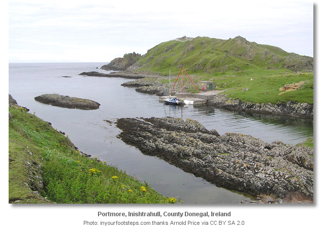
Portmore is an anchorage that affords good shelter and protection from all winds except those between north by northeast and east. Holding however can be poor in the rocky inlet. Attentive navigation is required for access, as the surrounding inlet is fringed with rocks and the area is subject to strong currents, tidal races and surge. Great caution should be exercised when approaching Portmore if a swell is running. Otherwise, it is more than manageable.

Keyfacts for Portmore

Nature


Considerations


Protected sectors


Summary
A good location with attentive navigation required for access.
Nature


Considerations


Position and approaches
Haven position
 55° 26.020' N, 007° 13.880' W
This is the anchoring location in the cut at the north side of the Island.
What are the key points of the approach?
 .
.- Vessels approaching from the east will find open water all the way to Inishtrahull and Portmore.
- Vessels approaching from the west should avoid the Garvan Isles and will find it easier to round Inishtrahull's southern side.
- Align a bearing of 227° T of the conspicuous red tripod crane situated on the Portmore quay and track into the cut.
- Pass between the flanking outer rocks and continue up the centre of the cut.
Not what you need?
- Portachurry - 0.5 nautical miles SW
- Malin Harbour or Slievebane Bay - 5.1 nautical miles SW
- Culdaff Bay - 8.5 nautical miles SSE
- Tremone Bay - 11.1 nautical miles SSE
- Kinnagoe Bay - 13 nautical miles SE
- Lenan Bay - 15.3 nautical miles SW
- Portkill - 15.5 nautical miles SE
- Portnocker - 16 nautical miles SE
- White Bay - 16.2 nautical miles SE
- Moville - 16.2 nautical miles SSE
- Portachurry - 0.5 miles SW
- Malin Harbour or Slievebane Bay - 5.1 miles SW
- Culdaff Bay - 8.5 miles SSE
- Tremone Bay - 11.1 miles SSE
- Kinnagoe Bay - 13 miles SE
- Lenan Bay - 15.3 miles SW
- Portkill - 15.5 miles SE
- Portnocker - 16 miles SE
- White Bay - 16.2 miles SE
- Moville - 16.2 miles SSE
Chart
What's the story here?

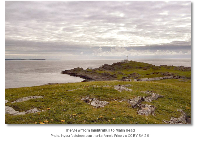
Inishtrahull is situated of the north coast of Ireland three miles northwest of the outermost Garvan Isle across Inishtrahull Sound. It is nearly a mile long and is made up of two rounded hills joined by a stretch of low ground with a prominent lighthouse at its western end. Portmore is the island’s best berth and it is set into a small inlet on the north side of the island.
How to get in?
 Careful advance planning is required by western approaching vessels as this corner of Ireland has to be treated with the utmost respect. Here the Atlantic Ocean collides with the runs of the Irish coastal tide amidst two rocky island groups. Inishtrahull island lies five miles offshore and is made readily conspicuous by its lighthouse.
Inishtrahull Lighthouse - Fl(3)15s 59m19M position: 55° 55 25.864’N, 007° 14.628’W

Keep well clear of the Garvan Isles located to the east of Malin Head and to the north of Slievebane Bay on the mainland. These are a collection of barren islands, ranging from 15 to 22 metres in height, surrounded by sunken rocks and shoals. The north easternmost danger of this group is the outlying Doherty Rocks that are awash. Inishtrahull sound, situated between the Garvan Rocks and Inishtrahull Island is deep, 3 miles wide and free of any outlying dangers.

Vessels closing on Inishtrahull from the west will find it less complicated to come around the south of the island through Inishtrahull Sound. The south and eastern shores of Inishtrahull are steep to, free of off lying dangers and can be approached as close as 100 metres. The north shore by comparison is foul with the off-lying ‘Blind Rocks’ extending 300 metres north of Inishtrahull. A safe passage can however be made through the 1,000 metre wide Tor Sound that lies between Blind Rocks and Tor Rocks further north.
 Vessels approaching from the east will find open water all the way to Inishtrahull. Those taking an offshore approach will find Inishowen Head provides the principal landmark. On closer approaches the bluff headland of Glengad Head will be seen with a remarkable hill near its extremity. Steer out directly to Inishtrahull's eastern point from Glengad Head a distance of six miles.
 The Portmore initial fix set on a bearing of 227° T half a mile out from a conspicuous red tripod crane situated on the Portmore quay. Track into the mouth of the inlet on this bearing. Be prepared for a whirlpool in this area, off the northeast point of Inishtrahull and at the entrance to Portmore, that can be ferocious on springs.
Final approaches are all about the eyeball navigation required to pass the skirting rocks on either side of the inlet. The rock on the north side is at the extremity of a reef and is always visible to 0.2 metres. But the southern rock dries to 3.1 metres and is entirely covered at high water Springs. Once aligned on these flanking rocks continue up the centre of the cut. It is clean on both sides and has depths that gradually decrease from 9 - 11 metres, just inside the flanking rocks, to about 4 metres alongside the pier.

 Deeper draft vessels can anchor in the mouth or in the neck of the inlet where 10 and 5 metres will be found and space for three to four vessels. Vessels anchoring in the neck should carefully gauge the swing room so as not to allow the vessel to drift onto the ledges either side of the bay.
The quay has a minimum of 3 metres alongside and those who plan to berth here should do so at the inner corner or southwest end to permit access to a pool alongside the quay. The single issue with the pier is a rock with 1.1 metres over it that lies less than 8 metres off the outer end of the quay. Vessels carrying any draft will have to come straight in alongside and reverse straight out on exit to avoid this danger.
Smaller vessels with a shallower draft can venture in closer into the rocky rectangular shaped box-like cut alongside the quay. This enclosed small pool is immediately adjacent to the quay and measures 18 metres by 24 metres with a LWS depth of 1.7 metres. The entrance to the pool is obstructed by the aforementioned 1.1 metres rock situated close north to the outer end of the quay. Hence the pool should be entered through the gap between the rock and the quay, by passing alongside the face of the quay.
Those planning to stay in the pool overnight can make use of a ringbolt to deal with the inner pools limited swing room. This is set into a rock opposite the inner, or south-western end, of the quay. By dropping the anchor in the middle of the pool and taking a stern line from the ringbolt the vessels movement can be safely confined.
Why visit here?
Inishtrahull’s name is derived from Irish, Inis Trá Thuathail which, when spoken by Gaelic speakers from west Donegal the pronunciation is almost identical. The Gaelic means ‘the island with the strand on the opposite side’ which is a description of its best landing position. The south side, facing the mainland, is open to the Atlantic and the island’s northern side, at Portmore, presents the only safe landing position.

Inishtrahull’s commanding lighthouse is the most northern lighthouse in Ireland. Situated on the western side of the island it is a reinforced concrete structure that includes an accommodation block and a slim white 23 metres tall tower to the balcony, plus a further 5.7 metre tall lantern. Flashing white 3 times every 20 seconds it is the dominating feature of the island. Coupled with the lighthouse on Tory Island they form the two main landfall lights for Atlantic shipping rounding the north coast of Ireland. But this lighthouse was not the original Inishtrahull lighthouse as it only entered service in October 1958. Prior to that the first and original lighthouse was situated at the east end of the island. This was established in March 1813 to support Royal Navy ships using Loughs Swilly and Foyle. It was discontinued in October 1958 to make way for the new structure and its substantial ruins can be visited today. The stub of the original 12.8 meter tower still stands along with derelict living quarters plus other detritus such as fuel tank, steels, cogs, and old bits of machinery.
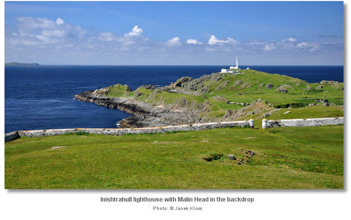
Today, except for visiting lighthouse personnel and the occasional passing boatman, the island is left to the waters and the wild. Owned by the Commissioners of Irish Lights it has been designated a Nature reserve by the National Parks and Wildlife Service. Being a remote island in a pivotal position with the unique 90 metre deep Inishtrahull Sound adjacent to its southern side, plus rocky shallows to its north, and fast running currents, it supports a host of wildlife. Basking shark, cetaceans and sunfish can be seen in the Sound in large numbers during the summer months and seals abound. A small herd of sika deer are also on the island but they are so shy and fleet-of-foot that it is unlikely a small party from a boat would ever catch sight of them whilst ashore. The island attracts many unusual birds including, Purple Sandpiper, Turnstone, Oystercatcher, Barnacle Goose, Peregrine, Arctic Tern, plus a significant breeding Shag and Eider population. As such particular care is requested of visitors during the bird breeding period from May through to July.
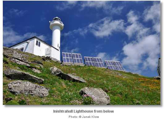
Portmore is an exceptionally good anchorage but not a location that lends itself to a forward calendar entry. Complex tides around the island appear very quickly producing standing waves with the least provocation. But for the coastal cruiser passing this corner, when conditions are favourable and an auspicious weather window opens, boatmen will find a very special and enchanting island that should not be passed by.
What facilities are available?
There are no facilities on Inishtrahull save for the small quay. There is a maintained well at Portmore but the water is stagnant and not great, and would need to be boiled. A much better well is to be found below the northern wall of the old school house.Any security concerns?
Never an issue known to have occurred to a vessel in this isolated location.With thanks to:
Bill McCann, Londonderry Harbour Master and Gerry Sóna. Photography with thanks to Abhainn Cruises, Andrew Hurley, Margaretincarn, Arnold Price, Petre Broze and a special thanks to Janek Kloss.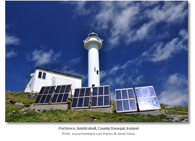


This video presents a good overview of the Portmore.
Touring the island’s legacy of early 20th century inhabitation.
Vintage Inishtrahull Lighthouse video showing its Keepers in the early 1960s
Add your review or comment:
Denis Hutton wrote this review on Jul 15th 2013:
This site has been a brilliant discovery for me, so informative, thanks
Average Rating:


Please log in to leave a review of this haven.
Please note eOceanic makes no guarantee of the validity of this information, we have not visited this haven and do not have first-hand experience to qualify the data. Although the contributors are vetted by peer review as practised authorities, they are in no way, whatsoever, responsible for the accuracy of their contributions. It is essential that you thoroughly check the accuracy and suitability for your vessel of any waypoints offered in any context plus the precision of your GPS. Any data provided on this page is entirely used at your own risk and you must read our legal page if you view data on this site. Free to use sea charts courtesy of Navionics.


