
Nestled deep within the upper reaches of England’s most extensive natural harbour, Shipstal Point’s protection is very good and it is easily the most protected anchorage the harbour has to offer. Access however is shallow and it is more suited to those with moderate drafts and who are prepared to work the tides for access. Once in, there is plenty of water especially so in its deep water pool. Access is well marked and straightforward in almost all reasonable conditions.
Keyfacts for Shipstal Point
Facilities


Nature


Considerations

Protected sectors
Approaches


Shelter


Last modified
July 18th 2018 Summary* Restrictions apply
A good location with attentive navigation required for access.Facilities


Nature


Considerations

Position and approaches
Expand to new tab or fullscreen
Haven position
 50° 41.650' N, 002° 1.412' W
This is the location of the deepwater pool off Shipstal Point.
What are the key points of the approach?
Offshore details are available in the westbound  or eastbound
  sequenced 'Selsey Bill to Start Point' coastal description. Entry into Poole Harbour and the run up to Poole are covered in the Poole Town Quay
  entry.
 or eastbound
  sequenced 'Selsey Bill to Start Point' coastal description. Entry into Poole Harbour and the run up to Poole are covered in the Poole Town Quay
  entry.
- Branch off into the Wych Channel at the large No.18 Port buoy located northeast of Brownsea Island.
- Follow the well-marked Wych and then Upper Wych all the way up to Shipstal Point.
Not what you need?
Click the 'Next' and 'Previous' buttons to progress through neighbouring havens in a coastal 'clockwise' or 'anti-clockwise' sequence. Below are the ten nearest havens to Shipstal Point for your convenience.
Ten nearest havens by straight line charted distance and bearing:
- Lake Yard Marina - 1 nautical miles N
- Poole Yacht Club - 1.3 nautical miles NE
- Brownsea Island - 1.3 nautical miles E
- Port of Poole Marina - 1.6 nautical miles ENE
- Poole Town Quay - 1.7 nautical miles NE
- Goathorn Point - 1.7 nautical miles ESE
- Poole Quay Boat Haven - 1.8 nautical miles NE
- Cobb's Quay - 1.9 nautical miles NNE
- Ridge Wharf Yacht Centre - 2.5 nautical miles WSW
- Parkstone Yacht Club - 2.6 nautical miles ENE
These havens are ordered by straight line charted distance and bearing, and can be reordered by compass direction or coastal sequence:
- Lake Yard Marina - 1 miles N
- Poole Yacht Club - 1.3 miles NE
- Brownsea Island - 1.3 miles E
- Port of Poole Marina - 1.6 miles ENE
- Poole Town Quay - 1.7 miles NE
- Goathorn Point - 1.7 miles ESE
- Poole Quay Boat Haven - 1.8 miles NE
- Cobb's Quay - 1.9 miles NNE
- Ridge Wharf Yacht Centre - 2.5 miles WSW
- Parkstone Yacht Club - 2.6 miles ENE
Chart
How to get in?

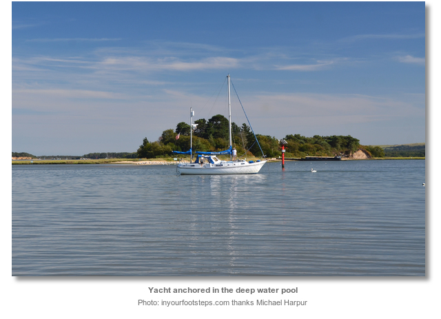
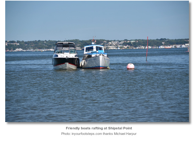
Shipstal Point lies off the Arne Peninsula, to the north of Dorset’s Isle of Purbeck that juts into the southwest corner of Poole Harbour. It is a shallow creek situated 1⅓ miles west of Brownsea Island at the head of the Upper Wych Channel. The area has some private moorings but there is room to anchor in depths of from 0.5 up to the 2.5 metres, which can be found in its deep water pool.
Approaches through Poole Bay and Harbour provide drafts of no less than 6 metres CD up to the entrance to the Wych Channel and the run up to Pottery Pier has not less than 2.3 metres. But the Upper Wych Channel is very shallow with depths as little as 0.3 metres CD in parts, so it is essential to work the tides for access.
 Entry into Poole Harbour is covered in the Poole Town Quay
  entry and the run up to Pottery Pier, on the western extremity of Brownsea Island, is covered in the Brownsea Island
  entry.
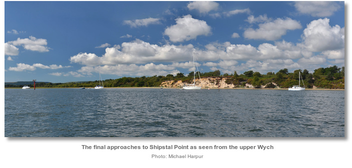
Follow the Upper Wych Channel for about 2 miles as it passes south of Pottery Pier then turns northwest and west towards Shipstal Point. Then, after a sharp turn southward, it passes between Long Island and Round Island after which it dries. The Wych is marked all the way to Round Island by stakes and Shipstal Point's exposed cliff makes it conspicuous throughout the western end of the harbour.

There are two shortcuts available across the harbour from Poole Town Quay area. The first is the well-marked Will's Cut, that has a minimum draft of 0.5 metres CD and connects the Wych and Middle Ship channels, described in the Brownsea Island
 entry.
 The other cut is situated nearly a mile above and cuts across Balls Lake. This lies to the south of the WH2, Fl.R.2s, port buoys and is marked by an east cardinal beacon 150 metres to the southeast of WH2 buoy. This connects with a corresponding east cardinal beacon a ⅓ of a mile southward on the Upper Wych Channel on the opposite side of Balls Lake. This cut is shallower than Will's Cut offering a minimum draft of 0.2 metres CD.

 Anchor according to draft, clear of any moorings and a cable that crosses from Round Island to the mainland which is marked by beacons. Best depths are to be found in a pool situated between the point and the northwest corner of Long Island. Its south-eastern corner is marked by a port beacon. All is soft mud in the creek so if you do touch little harm will come of it. The harbour’s deep cloying black mud offers excellent holding.

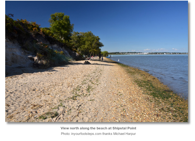
Land on the beach preferably at high water, which is lengthy thanks to the harbours long stand. At low water it is best avoided as it becomes a wade through black cloying mud.
Why visit here?
Shipstal name is not believed to have been derived from anything nautical, such as a ship, but from the agrarian ‘sheep’s stall’.Set on the Arne peninsula, which protrudes deep into Poole Harbour, the area has an abundance of evidence indicating prehistoric human habitation. There are nineteen barrows or prehistoric monuments in the area with the most significant being 'King's Barrow'. Situated at Stoborough this funerary monument dates from the late Neolithic period to the late Bronze Age. It was first excavated in 1767 when a primative inhumation, without a skull, was found. The remains were wrapped in stitched animal skins secured within a hollowed out tree trunk coffin. An unusual funerary urn was found alongside. There are also the remains of four linear dykes of Romano-British origins and it was likely that a Roman saltern existed on the shores here.

In the 16th or 17th century the upper part of the western end of St. Nicholas’ nave was walled off to create a bell-chamber and its current bell's registered date is 1762. It was restored in the middle of the 19th century and again in 1952 to repair war damage. Apart from this it has not been substantially altered suggesting the area has had a small population throughout the best part of a millennium. The largest population recorded here was 123 in 1894 from which it declined.
In 1966 the Royal Society for the Protection of Birds (RSPB) turned the sparcely populated area into to a nature reserve, and it is for this that Arne is most famous today. Within the RSPB’s purview is the peninsula’s heathland, woods and ponds right down to the edge of the salt marshes stretching out into the upper reaches of Poole Harbour. All of which provide perfect breeding and feeding grounds for innumerable birds that can be watched from its various screens and hides. In the summer and autumn it is also possible to see herds of Sika deer grazing on the saltmarshes. These wildlife sightings and the untamed sounds make this an enchanting anchorage.

The islands opposite the reserve are privately owned and no landings are permitted even below the high water line. The 31 acre Long Island is a Site of Special Scientific Interest protected by English Nature. It has beaches, cliffs, heathland, salt marshes and both evergreen and deciduous woodland. This provides a home to an abundance of birds and sika deer, as well as the rare red squirrel. The island was privately owned by the Rempstone Estate since the 1800s when it was purchased as part of a vast area of land on the south side of Poole Harbour. In 2007 it went up for sale and an application was made by pleasure boaters, who had used the island at their leisure for decades, to officially secure their right to use the island. The leisure boaters lost their case and the estate was then sold to a local property developer in 2010 for £3 million without any planning permission being granted.

The smaller 15 acre Round Island is only separated from Long Island by a narrow channel scarcely a metre wide. It is permanently inhabited by its caretaker couple and their two children. It has three holiday cottages that are available for rent. The jetty, extending west from the island, provides its guest with all tide access from the Upper Wych over its surrounding muds.
From a boating perspective Shipstal Point provides one of the best anchorages in the harbour. Should weather conditions deteriorate Shipstal has the protection of the mainland immediately to the west and north, the shelter from the islands to the east and the drying marsh lands to the southwest. Though sequestered, Poole Harbour and its hidden recesses are all accessible by any dinghy equipped with a respectable outboard.
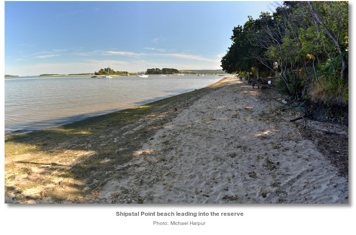
There is plenty here to enjoy in this unique location. Boats that arrive here not only have the benefit of the mirror like waters of the upper creek, but beautiful local scenery and extensive views of the Purbeck Hills, Poole Harbour and its islands beyond. Shipstal Point has a lovely beach to land upon and spend the day with the family. From there the paths of the RSPB reserve, lead in through the 563 hectare (1250 acre) nature reserve of ancient oak woodland, pine forest, rare lowland heath, salt marsh and ponds. The village, with the little church of St. Nicholas prominent despite its diminutive stature, it being sited on top of a large bank, is about a fifteen minutes’ walk.
What facilities are available?
The RSPB has a cafe that serves hot food made from local produce. It has toilets that include disabled and baby-changing facilities. Picnic areas can be found in the reserve.With thanks to:
John Binder CMM Poole Quay Boat Haven & Port of Poole Marina manager. Photography with thanks to Michael Harpur.




Add your review or comment:
Please log in to leave a review of this haven.
Please note eOceanic makes no guarantee of the validity of this information, we have not visited this haven and do not have first-hand experience to qualify the data. Although the contributors are vetted by peer review as practised authorities, they are in no way, whatsoever, responsible for the accuracy of their contributions. It is essential that you thoroughly check the accuracy and suitability for your vessel of any waypoints offered in any context plus the precision of your GPS. Any data provided on this page is entirely used at your own risk and you must read our legal page if you view data on this site. Free to use sea charts courtesy of Navionics.


