
_england_NIC_2897_stitchSMALL.jpg)
Dartmouth Harbour lies on England's south coast between Start Point and Berry Head. The extensive natural harbour is a major centre for leisure craft, with three marinas along with a range of municipal harbour berthing opportunities.
A deep river valley naturally protected by an offset entrance Dartmouth Harbour and the River Dart is a sheltered haven with most of its berthing opportunities providing complete protection. Although the entrance is fringed by several dangers they are all well marked by lighted buoys and leading lights that make approaches straightforward at all stages of the tide, night or day. Special care is required in developed southerly and southeasterly conditions as in these circumstances the swell can build up in the narrows of the entrance which can get particularly rough on the ebb.

Keyfacts for Dartmouth Harbour


Last modified
February 12th 2019 Summary
A completely protected location with straightforward access.Facilities


 pump out facilities")


Nature


Considerations

Position and approaches

Expand to new tab or fullscreen
Haven position
 50° 20.575' N, 003° 33.862' W
This is the middle of the entrance between Dartmouth Castle and Kettle Point.
What is the initial fix?
The following Dartmouth Harbour Initial Fix will set up a final approach:
 50° 19.616' N, 003° 32.923' W


What are the key points of the approach?
Offshore details are available in southwestern England’s coastal overview from Portland Bill to Start Point 
- Do not cut in on either side of the approaches as each side of the entrance is fringed with many rocks.
- From 1¼ miles southward of the entrance, in the white sector of the (325°-331° T) of Kingswear Light, steer to pass 100 metres west of the of the Castle Ledge starboard buoy, Fl.G.5s.
- Then steer to pass east of the 'Checkstone' port buoy, Fl (2)R.5s.
- Enter the River Dart between the castles and follow the path of the river keeping to the starboard side of mid-channel.
Steer to keep well south of the two south cardinals that mark Mew Stone and Combe Point from the east and Homestone port buoy, Q.R. from the west.
Not what you need?
Click the 'Next' and 'Previous' buttons to progress through neighbouring havens in a coastal 'clockwise' or 'anti-clockwise' sequence. Below are the ten nearest havens to Dartmouth Harbour for your convenience.
Ten nearest havens by straight line charted distance and bearing:
- Dittisham & The River Dart - 2.6 nautical miles NNW
- Brixham - 4.2 nautical miles NNE
- Paignton - 5.4 nautical miles N
- Torquay - 7 nautical miles N
- Hallsands - 7.5 nautical miles SSW
- Hope Cove (Tor Bay) - 7.9 nautical miles NNE
- Anstey’s Cove - 8.3 nautical miles NNE
- Babbacombe Bay - 8.6 nautical miles NNE
- Kingsbridge - 8.9 nautical miles WSW
- Watcombe Cove - 9.4 nautical miles NNE
These havens are ordered by straight line charted distance and bearing, and can be reordered by compass direction or coastal sequence:
- Dittisham & The River Dart - 2.6 miles NNW
- Brixham - 4.2 miles NNE
- Paignton - 5.4 miles N
- Torquay - 7 miles N
- Hallsands - 7.5 miles SSW
- Hope Cove (Tor Bay) - 7.9 miles NNE
- Anstey’s Cove - 8.3 miles NNE
- Babbacombe Bay - 8.6 miles NNE
- Kingsbridge - 8.9 miles WSW
- Watcombe Cove - 9.4 miles NNE


What's the story here?
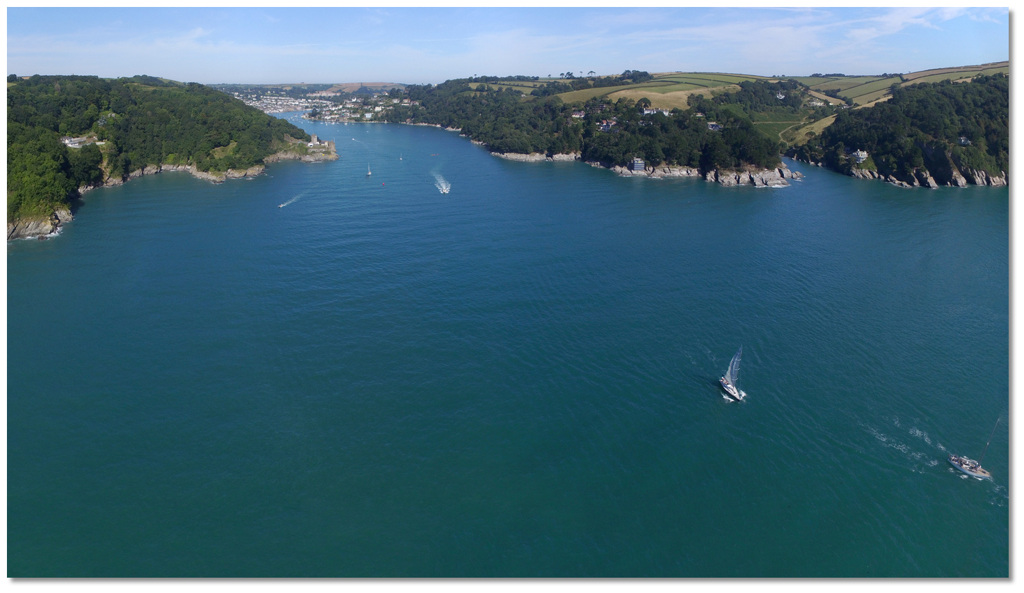 Dartmouth Harbour and its approaches
Image: Michael Harpur
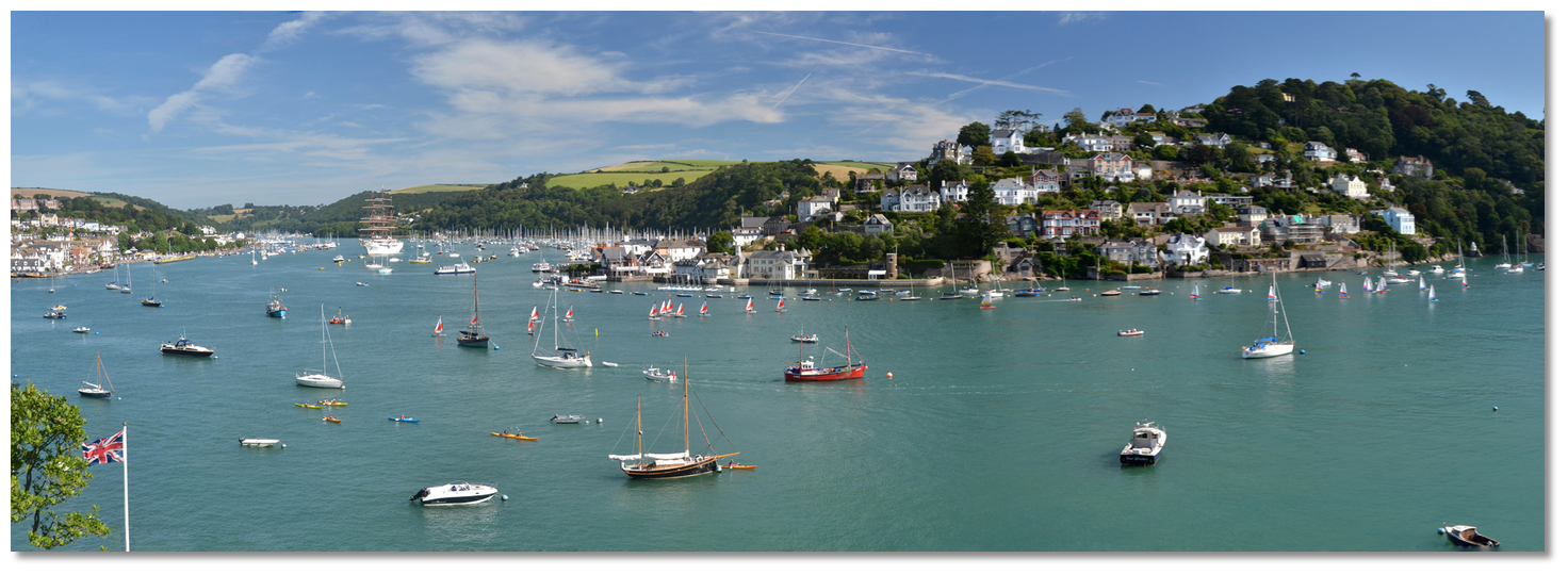
Dartmouth, also Darthaven or Dart Harbour, is beautifully situated on the west bank and close to the mouth of the River Dart, which at the entrance forms an almost land-locked estuary. The river exits into the sea 7½ miles northeast of Start Point and 5 miles southwest by west of Berry Head. It is a long narrow tidal river which is navigable for 10 miles inland as far as the old weir location at Totnes. The historic town of Dartmouth is situated on the west bank, about a ½ mile above the entrance, with the smaller town of Kingswear standing opposite on the east side of the river.
With three marinas, 1,600 permanent moorings and a range of municipal berthing locations, the harbour is principally a leisure port but it is also home to many local fishing vessels and large cruise ships, and naval ships still enter to moor in midriver. None of the marinas hold dedicated visitor berths but even in peak season visitors will always find space somewhere and no one gets turned away.
All berthing is controlled by the Dart Harbour and Navigation Authority (DHNA) whose role is to make leisure visits to the area as pleasant and trouble-free as possible. No berthing is allowed without permission of the Harbour Master and wherever you berth, even in the private marinas, all vessels have to pay the harbour dues which are (2018) 85p per metre per day and are payable for all vessels except those under 4 metres.
Arrivals should contact Dart Harbour by VHF to arrange to berth. The DHNA may be contacted on
 Ch. 11 [DARTNAV],
  +44 1803 832337/833767,
  www.dartharbour.org,
  info@dartharbour.org. For urgent issues out of hours please call the duty Harbour Master on
  +44 7968 839846. If you intend to stay for more than 14 days please make the Harbour Office aware of that straight away. Overnight berthing against the fuel barge, stationed on the east side of the main channel, is not permitted.
 DHNA berths are available on a strict first come first served basis and may not be available at certain times due to maritime events. For a small additional fee, the DHNA will accept an advance booking.
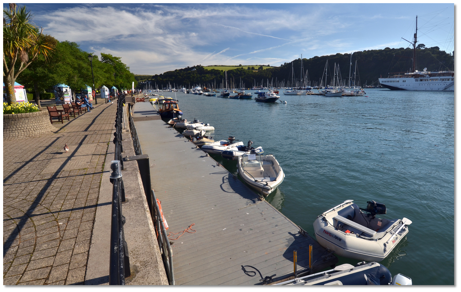
 Dartmouth Harbour visitor options
Image: Michael Harpur
The DHNA provide a range of berthing options throughout the harbour. Their berths are generally marked with blue flags, yellow boards with 'visitors' written upon them and their mooring buoys are blue with a black 'V'. Dinghy moorings have a blue flag with a diagonal black cross. The DHNA berthing opportunities present themselves in the following order as a vessel proceeds upriver:
 Dartmouth Yacht Club Pontoon
Image: Michael Harpur
Dartmouth Yacht Club Pontoon has a seasonal walk ashore pontoon just north of Lower Ferry on the west side of the river. The pontoon can take vessels of up to 9 metres LOA. Rafting is possible on the outside but only two deep. Being lower down the harbour this pontoon can suffer from swell and although you can walk-ashore there is no water or electricity.
Mono-hull: £1.35 per metre per day Multi-hull: £2.10 per metre per day
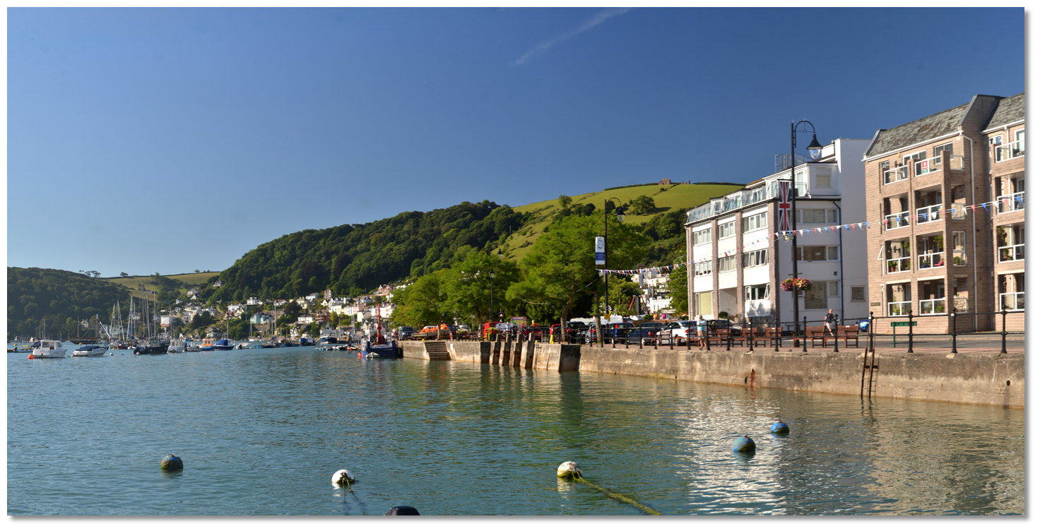
 South Embankment Quayside
Image: Michael Harpur
Between Dartmouth Yacht Club pontoons and Town Jetty on the west side of river. This is a short stay location that can only be used with the permission of the Harbour Master. The steps and ladders should not be obstructed and boats are not to be left unattended. The fish quay is about halfway along the Embankment and has a davit on its southern end. This is in frequent use by the local fishing fleet. Be advised this area dries out on certain tides and should only be used by a vessel that can take to the ground. Secure the vessels very well, as the seabed slopes away from the quay wall.
Mono-hull: £1.35 per metre per day Multi-hull: £2.10 per metre per day
 Town Jetty
Image: Michael Harpur
The town jetty provides DHNA's only walk ashore pontoon and is suitable for disabled persons. The inside berth provides 24hr berthing and can take vessels of up to 20 metres LOA and rafting is permitted two vessels deep. There is space for about three average sized boats alongside inside the pontoon and another three rafted up. The charted depth inside the southern end of the town jetty is 2 metres and it shallows towards the embankment.
Mono-hull: £2.30 per metre per day Multi-hull: £3.30 per metre per day water and electricity included in the charge. Tenders up to 4.3 metres may berth alongside the marked area inside free for up to 2 hours. Fees apply if any longer.
The outside berth is used by ferries during the day but vessels of up to 34 metres LOA can come alongside from 1700 - 0845hrs April to October, and 24hrs from November to March when the pleasure boats stop. Vessels should come alongside south of the bridge and not obstruct the passenger ferry’s that operate from the north end.
Mono-hull: £1.35 per metre per day Multi-hull: £2.10 per metre per day. Water and electricity included in the charge.

 North Embankment Quayside
Image: Michael Harpur
This is a drying berth to the north of Town Jetty and on the west side of the river next to the steps in front of a block of flats. This area dries out over piles spaced 1 metre apart or in mud slightly further up the quay, but do not block steps and ladders. The scrubbing grid is under the control and management of South Hams District Council. This is short-stay only and there is no electrical outlet here.
Mono-hull: £1.35 per metre per day. Multi-hull: £2.10 per metre per day.
 DC Visitors Pontoon
Image: Michael Harpur
Opposite the Boatfloat on the west or the Dartmouth side of the river just above the Town Jetty. This is a small mid-river non-walk ashore pontoon that does not have water or electricity. It can take vessels up to 12 metres LOA and permits rafting two deep only. Charted depths here are in excess of 3 metres.
Mono-hull: 85p per metre per day. Multi-hull: £1.20 per metre per day.
 DA Visitors Pontoon
Image: Michael Harpur
This is situated to the south of Higher Ferry, on the west or Dartmouth side of the river. This is a long mid-river and non-walk ashore pontoon with no water or electricity. Visitors can only berth on the outside of this pontoon as the inside is reserved for berth holders only. This pontoon can take vessels up to 12 metres LOA with room for about 10 average sized boats. Charted depths here are 2 metres or more. Rafting up to two deep is allowed, with more than two deep only permitted with the approval of the Harbour Office.
Mono-hull: 85p per metre per day. Multi-hull: £1.20 per metre per day.
 Deepwater Visitor Pontoons 1, 2 & 3
Image: Michael Harpur
These are above the fuel barge and south of Higher Ferry on the Kingswear east side of the river. This is a long run of mid-river non-walk ashore pontoons with no water or electricity. It can take vessels up to 14 metres LOA with depths in excess of 9 metres and vessels are permitted to raft up to two deep.
Mono-hull: 85p per metre per day. Multi-hull: £1.20 per metre per day
Deepwater visitor moorings are available mid-stream for vessels larger than 14 metres. These are yellow mooring buoys, downstream of the Fuel Barge, and can be picked up subject to availability.
The Royal Dart Yacht Club is situated just inside the entrance of the River Dart, on the eastern Kingswear bank and just south of the Lower Ferry.
 Royal Dart Yacht Club
Image: Michael Harpur
The club accepts visitor boats of up to 9 metres LOA on its summer pontoon outside the club. Power and water are available on the pontoon and the club allow the use of their showers, bathrooms and a launderette. Visitors should make enquires in advance about berthing
+ 1803 752272/752496, www.royaldart.co.uk. Darthaven Marina is situated upstream of the Lower Ferry on the Kingswear side of the river opposite the historic town of Dartmouth. It has 270 berths in total, set over four main pontoons and is capable of accommodating vessels of up to 21.3 metres LOA carrying up to 3.7 metres draught.
 Darthaven Marina
Image: Michael Harpur
The marina does not hold dedicated visitors' berths but does accommodate visitors in slots freed up by absent resident berth-holders. They do not take visitor bookings in advance but if you are planning on arriving on a specific date, it is worthwhile to contact them prior to your trip so they can do their best endeavours to accommodate you. In all other cases call them on
+44 1803 752545 or Ch. 80 before the approach to Darthaven, www.darthaven.co.uk. Visitor berthing (2018) £2.50 per night per metre LOA excluding harbour dues.Please note the southern outboard section of the most southerly pontoon is to be kept clear for use by a DHNA yacht taxi and is not to be used by visitors.
Dart Marina is situated at Sandquay on the western side of the river just above the Higher Ferry. It has 120 berths and can accommodate yachts up to 18 metres LOA and 2 metres draught.
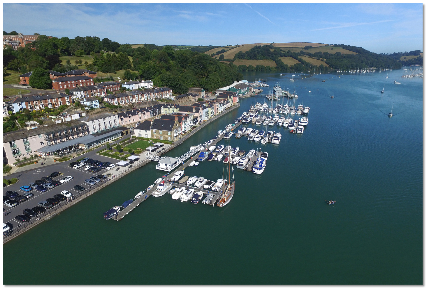 Dart Marina
Image: Michael Harpur
The marina does not hold dedicated visitors' berths but will try to accommodate visitors where they can in slots freed up by absent resident berth-holders. Contact Dart Marina on
Ch. 80 +44 1803 837161, www.dartmarinayachtharbour.com, to see what may be available on the day, price and availability. Noss on Dart Marina is situated a ½ mile above the Upper Ferry at Higher Noss Point on the east side of the channel. It has 180 pontoon moorings and 50 fore and aft berths, but their berths are so scarce that its resident berth-holders raft up in pairs.
 Noss on Dart Marina
Image: Michael Harpur
It is worth checking if anything is available on the day by contacting ‘Noss on Dart’
Ch. 80 +44 1803 839 087 or after 5 pm call +44 7920 425452.Visitor berthing is calculated per-night, based on midday to midday stay. Prices (2018) are per metre, per night, with a minimum charge equivalent to an 8 metre LOA:
8.0m - 12.5m - £3.10 | 12.6m - 16.0m - £3.30 | 16.1m - 20.0m - £3.80
It is possible to anchor off the Kingswear side of the channel, in the area between the Town Jetty and Darthaven Marina, just inside the large mainstream admiralty big-ship mooring buoys and outside of some local moorings off the marina. The holding is good but in wind-against-tide conditions can cause closely anchored dissimilar craft to swing into one another. Hence it is not advisable to leave a boat unattended until a couple of tidal changes have safely occurred. Use a trip line in this ancient anchorage and stay well clear of the ground chains for the harbour buoys.
 Permitted anchoring position
Image: Michael Harpur
The DHNA require all skippers intending on anchoring to abide by the following conditions:
- a) Vessels at anchor in the anchorage, or elsewhere, are to display the appropriate day and night lights, shapes or signals.
- b) Vessels must be capable of weighing anchor without assistance and moving at notice appropriate to the conditions or as required to do so by Dart Harbour.
- c) Vessels are not to anchor close to any buoy or mooring so as to make contact with or foul such apparatus in any way. Skippers are reminded of the charted ground gear on the seabed in the anchorage, used to secure the mid-river buoys.
- d) No anchoring is permitted in the vicinity of the Higher Ferry as this is a turning area for large vessels.
- e) Skippers and competent crew (those required to move the vessel) are to be onboard during the first turning of the tide after anchoring and are not to leave the vessel until they are certain that the holding is good and that the vessel will not interact with other vessels, moorings and pontoons. The vessel is not to be left unattended when inclement weather is forecast or when the forecast tidal stream may make the anchorage unsafe.
Vessels discovered that have been moored without their skippers complying with the above conditions may be removed for safety reasons and a charge will be made.
Anchoring space cannot be relied upon during busy times. During the Regatta this location tends to get especially overwhelmed. Sometimes with casual abandon, which can leave a skipper resorting to chaotic poling off.
How to get in?
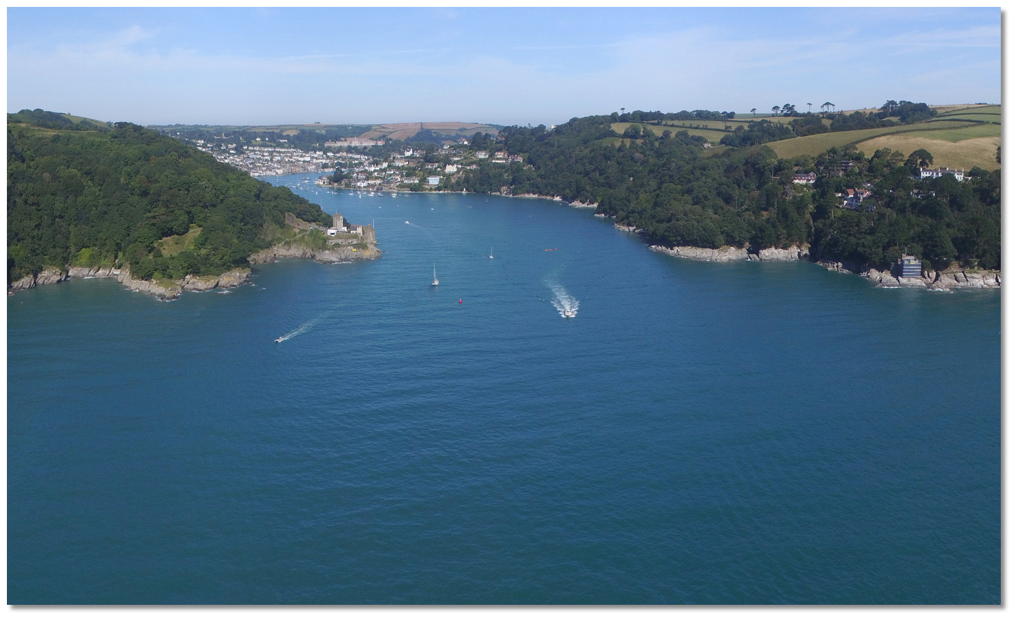 The entrance to Dartmouth Harbour
Image: Michael Harpur
 Use southwestern England’s coastal overview from Portland Bill to Start Point for seaward approaches. The entrance to Dartmouth Harbour is narrow and the opening does not readily offer itself to vessels coming from the south. The craggy 35-metre high Mew Stone Rock, however, makes it positively identifiable as does the 24-metre high stone tower daymark (unlit), at an elevation of 167 metres, on the hill behind Froward Point, east of the entrance.
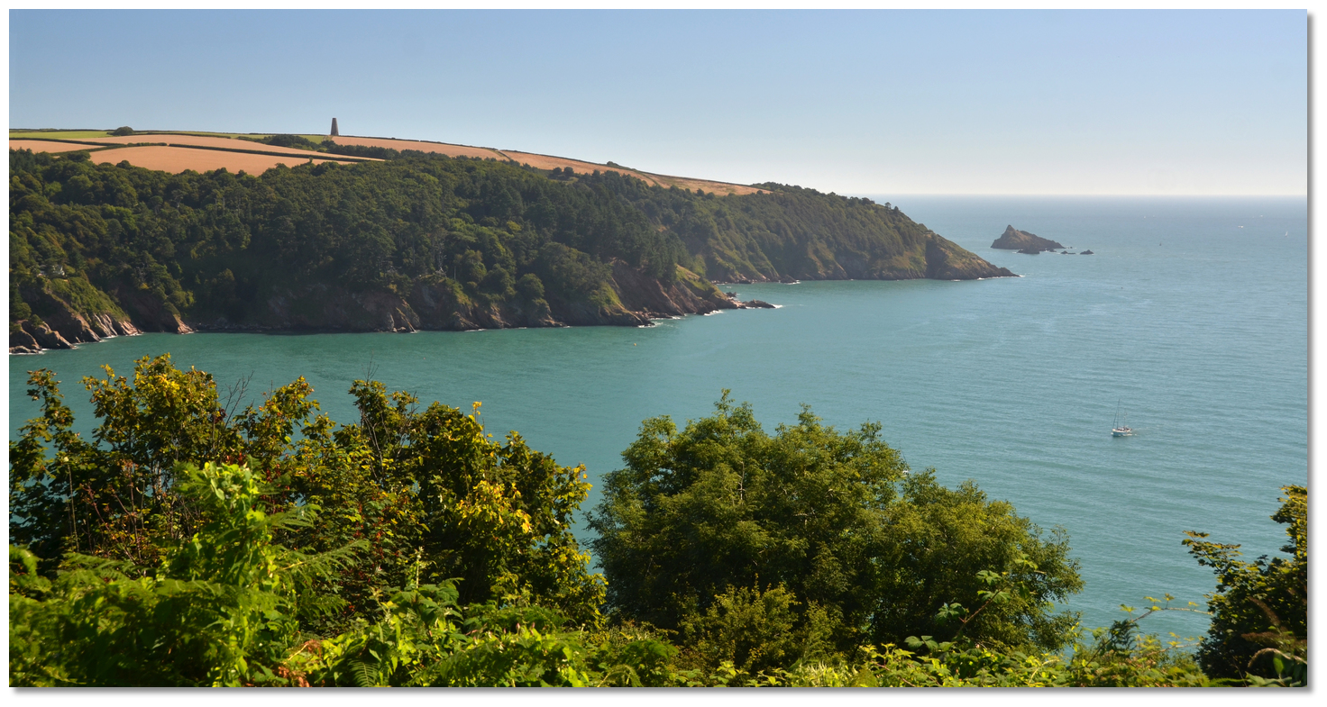 Mewstone Rock and the 24-metre high daymark on the hill behind Froward Point
Image: Michael Harpur
 Vessels approaching the initial fix from the east should keep well south of the two south cardinals that mark Mew Stone, in order to clear East Blackstone which is not marked. Do not be tempted to cut in from the West Rock cardinal, Q(6)+LF1.15s, as there are a number of dangers flanking the eastern approaches which include: The Verticals drying to 1.8 metres, the West Rock with as little as 0.9 metres over it, The Bear's Tail that dries to 0.6 metres over it, and Old Castle Rock with 1.8 metres over it. Worse, at high water ± 3 hours, the tidal stream sets towards all these dangers.
 From the west keep at least 500 metres south of Combe Point to avoid the Combe Rocks. These dry to 3.7 metres with many of them showing above water at all times and all of them showing at low tide. Then keep southward of the lit Homestone port buoy, Q.R., to avoid the dangerous covered Homestone Rocks that lie a ¼ of a mile east-southeast from Combe Point with as little as 0.9 metres of cover over it. Though a safe deep-water channel lies between the Homestone Rocks and the Combe Rocks it is not advisable for newcomers to cut the corner because of the Meg Rocks that dry to 3 metres, and Western Blackstone Rock that dries to 2 metres off of Blackstone Point.
 River Dart entrance overlooked by St. Petrox Church and Dartmouth Castel
Image: Michael Harpur
 From the initial fix steer north-westward to pass 300 metres southward of the Castle Ledge starboard buoy, Fl.G.5s that marks the extremity of the Castle Ledge. At night pick up the white sector of the (325°-331° T) Kingswear Light, Iso. WRG3s9m8M, a short white GRP tower on the Kingswear side.
  Dartmouth Castle and the Checkstone port buoy
 Image: Graham Rabbits
Keep the Castle Ledge over 100 meters to starboard and then steer for the Checkstone port buoy, Fl (2)R.5s. A harbour 6-knot speed limit begins at the Castle Ledge Buoy and extends to the weir at Totnes, with wash being kept to a minimum around moored vessels.
 Dartmouth Castle as seen from the entrance
Image: Neil Theasby via CC BY-SA 2.0
The entrance will be clearly visible at this stage with St. Petrox Church and Dartmouth Castle on the western side of the entrance, just within the Battery Point, and the Old Castle of Kingswear standing on the rocks near the water's edge on the eastern side. Pass Checkstone well to port to keep clear of the Kitten Rock, with 0.3 metres of water over it, that fringes the fairway here.
 Exiting yacht overlooked by Dartmouth Castle
Image: Michael Harpur
During springs localised tidal streams attain rates of 3kn which may be experienced off Battery and Castle Points. In developed south or southeasterly winds, a heavy swell may also be experienced in this area, and it can be particularly bad on the ebb. The swell and fast tides quickly moderate inside the estuary and almost entirely disappear at the Lower Ferry crossing point.
 Royal Dart Yacht Club and the Kingswear ferry pontoon
Image: Michael Harpur
Enter the River Dart between the castles and continue to follow the north-westward course keeping over to the starboard side of midriver until the valley opens up to westward. Then take the starboard side of a central course up the river. There is a mixture of private and Dart Harbour moorings on the western side of the river. The Royal Dart Yacht Club moorings are on the eastern side of the river. Follow until the river bends northward and the harbour opens out. When the river is well open continue up the harbour mid-stream.
 The lower ferry about to leave Dartmouth
Image: Neil Theasby via CC BY-SA 2.0
At night there is a fixed white sectored light on the eastern Kingswear side of the channel just to the north of Kettle Point. It is intended as a guiding light for vessels leaving but serves also as an astern light whilst entering (102°-107° T). This leads up to the white sector of the Bayard's Cove light, FI.WRG.2s5m6M, on the Dartmouth side, that tracks along the starboard side of the channel. Bayard's Cove light leads circa 293° T to abeam of Royal Dart Yacht Club where the main fairway opens. Keep in the Bayards Cove light until the lights on Kingswear ferry pontoon, 2F.G.(vert), are well open, and then it is safe to steer up through the harbour fairway.
 Higher Ferry approaching the Dartmouth Side of the river
Image: Michael Harpur
Keep well clear of the two chain ferries that manoeuvre in the narrow channel, as they have no steerage capability. The Lower Ferry is a push/pull that crosses from just south of Dartmouth Yacht Club to just around the point from Royal Dart Yacht Club on the Kingsmere side. Another floating bridge operates in the north part of the harbour, abreast of Sandquay, under its own power but again along guide wires.
 Darthaven Marina Plan
Image: Michael Harpur
Berth as arranged/directed by the DHNA or private marinas. Vessels that are berthed alongside a midriver pontoon can call the Dart Harbour Yacht Taxi, VHF Ch. 69, M: +44 7970 346571, or Puffin Water Taxis VHF Ch. 08, M: +44 07787 504007, or land by tender. Provided it is no larger than 4.3 metres the Dartmouth side has three walk-ashore pontoon areas:
 Green Pontoon on the North Embankment
Image: Michael Harpur
The Green Pontoon on the North Embankment permits berthing of up to 12 hours. Tenders should not be pulled up onto the pontoon for safety reasons.
 Double Steps pontoon to the north of Town Quay
Image: Michael Harpur
The Double Steps Pontoon is located to the north of Town Quay where it is possible to berth for up to 6 hours with no return within 6 hours. Do not obstruct the ‘Commercial Vessel’ Pontoon immediately to the South when making approaches.
 The Dartmouth Yacht Club pontoon
Image: Michael Harpur
The Dartmouth Yacht Club pontoon provides free berthing up to 2 hours with longer periods via a small fee. No return within 6 hours.
 Tenders inside Darthaven Marina's visitor pontoon
Image: Michael Harpur
On the Kingswear side the Kingswear Dinghy Rack provides berthing up to 6 hours and Darthaven Marina allows berthing for up to 2 hours on the inside of the visitors pontoon.
Why visit here?
Dartmouth gets its name from its Celtic river-name 'Dart' combined with the Old English word mütha, meaning 'mouth of the River Dart'. The river's name, occasionally spelt 'Darant', is said to have the Celtic meaning 'river where oak trees grow' due to the banks of the lower Dart being covered in ancient woods of native oak.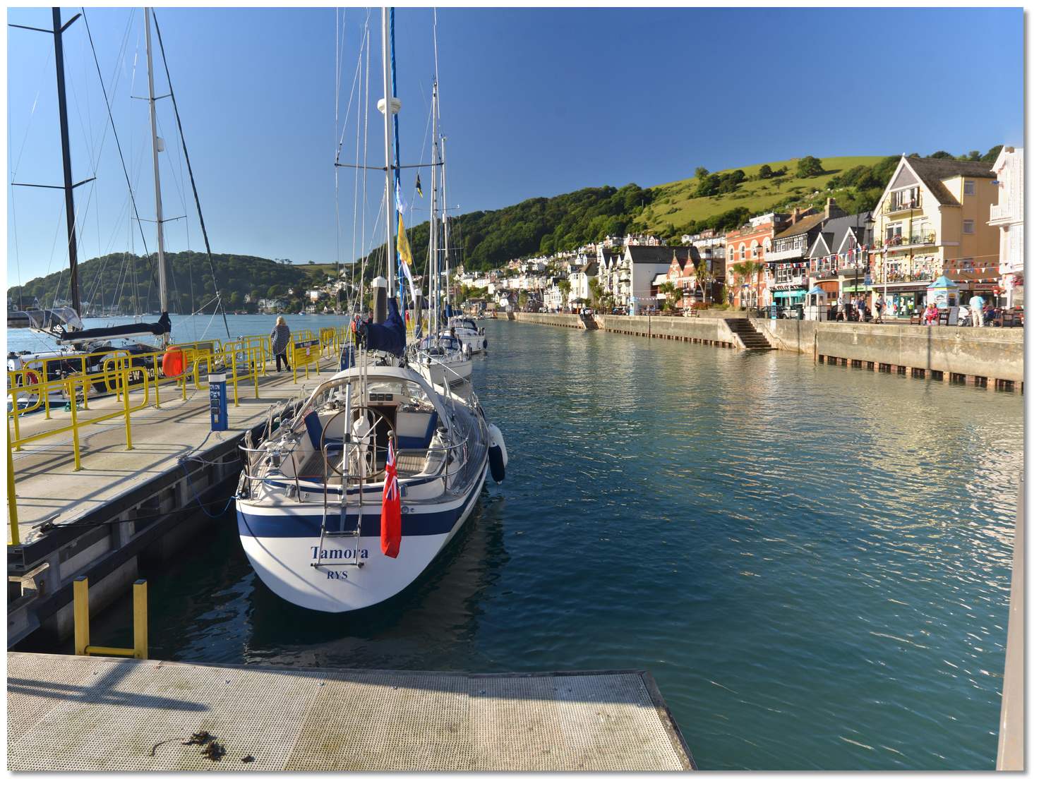 A berth that is steeped in maritime history
Image: Michael Harpur
Though the Celts and Saxons would have used the excellent natural harbour to establish themselves, they only built primitive settlements on the river banks and the surrounding hills. These would have been used to defend themselves from the marauding attacks of the Vikings and neither Dartmouth nor Kingswear are mentioned in Doomsday (1088). The only local settlement that Doomsday noted was Dunestal a nearby hilltop agricultural settlement around a church which became the present Townstal and part of the current parish of Dartmouth. The seafront area at this time was probably a small scattered collection of houses used by fishermen. Kingston, situated on the plateau above Kingswear about a mile to the east, is believed to have come from Saxon times with some evidence of Stone Age and Roman occupation.
.jpg) William II Norman king of England (1087 - 1100)
William II Norman king of England (1087 - 1100)Image: Public Domain
The name Dartmouth was first applied to the river mouth but from the early 13th-century onwards was given to the town that formed a little less than a mile within and on the west bank. This resulted from the coalescence of two small fishing hamlets of Hardness, on the north side, and Clifton on the south, that had come to establish themselves on the riverbank. These were originally separated by a tidal creek which ran well back inland and filled at high tide. This was dammed around the area of Foss Street which served to join the two settlements and created the deep ‘Mill Pool’ which powered two grain mills. In 1342 the town was incorporated by a charter frequently confirmed by later sovereigns.
 Warfleet today
Image: Neil Theasby via CC BY-SA 2.0
By this time the town of Dartmouth had grown considerably and its rich merchants were wealthy on the wine trade. In 1373 Geoffrey Chaucer visited and among the pilgrims in his Canterbury Tales he noted…
For ought I wost, he was of Dertemouthe.
 Geoffrey Chaucer
Image: Public Domain
Hawley proved to be an excellent privateer and not only did the agreement provide for untold wealth the services of Hawley and his followers served to protect the Devon shores from French invasion. Hawley was elected mayor of Dartmouth a total of 14 times, and also served twice as the town's MP and it was he who arranged for the first Dartmouth Castle to be built. So, somewhat hand in hand with the crown, Dartmouth became a major base for privateering. And during the 14th and 15th centuries, when there was a regular trade with Bordeaux and Brittany, complaints of piracy by Dartmouth men were frequent.
 Dartmouth Castle in 1794
Image: Public Domain painting by Paul Sandby
This also made the town a target for reprisals and in 1485 a royal grant was given for the walling of the town and the stretching of a chain across the river mouth. Dartmouth Castle then took on the imposing and well-preserved 'gun tower' with walls 2 metres thick, one of the first designed to withstand cannon impact. It was also the very first fortification in Britain purpose-built to mount 'ship-sinking' heavy cannon. Dartmouth's only wharf was then the relatively small Bayard's Cove at the southern end of the town which was well within the firing range of the fort. Kingswear Castle, at Godmerock, was then built opposite, in 1502, enabling a 230-metre chain between the two to be raised so as to close off the river. The castle would play a prominent part and was captured by both the royalists and parliamentarians in the Civil War.
 Sir Humphrey Gilbert c.1584
Image: Michael Harpur
As late as 1830 the trade of this town, arising from the Newfoundland fishery, employed about 3000 men in Dartmouth which had about 350 vessels involved in its trade, both in catching the fish and in carrying them. When the catch was cured they were taken to most part to ports in the Mediterranean, and the returning vessels would bring home, wine, oil, fruit, and salt. A number of ships are also employed in the pilchard fishery. Alongside this was an extensive shipbuilding industry that had built up to service the activity.
 A traditional trawler leaving the harbour in 1880
Image: Public Domain
This was Dartmouth's engine of growth from the 16th-century through to the 18th-century. During this time Dartmouth developed into a significant trading port and many buildings of that era still exist within the town today. The surviving 17th-century Butterwalk in Duke Street is one fine example. The Pilgrim Fathers would have used this when they put into Dartmouth's Bayard's Cove, en route from Southampton to America. Alongside this trade, contact with these new colonies expanded and by the 18th-century locally-made goods were traded with Newfoundland, whilst salted cod was sold to Spain and Portugal in exchange for wine. The town continued to thrive and expand with further reclamation of land from the river and 1825 a decision was taken to fill in the Mill Pool to accommodate Dartmouth’s growing population.
 Dartmouth and Kingswear in 1880
Image: Public Domain
But at this time the town went into precipitous decline on account of being largely disconnected from the developments of the industrial revolution. Steamships replaced the sailing ships that were traditionally built in the town, and local hand weavers lost their jobs. When the Newfoundland Fishing trade also collapsed in the mid-19th century, the town faced a serious economic downturn. The precipitous and difficult terrain then delayed the coming of the railway and when it finally arrived, in 1864 to Kingswear, Dartmouth resorted to becoming a bunkering port. A planned railway never reached Dartmouth so industrialisation never arrived. In 1863 the Royal Navy decided to train naval cadets on the Dart and moored two ships in the river for the purpose.
 Kingswear today as seen from Dartmouth Castle
Image: Michael Harpur
Towards the end of the 19th-century, the old wharves and slips along the river bank were becoming increasingly unsuitable for the larger ships of the Victorian era and a completely new waterfront comprising the North and South Embankments was constructed and opened in 1885. This waterfront was extended in the 1930s up to the Higher Ferry which involved the reclamation of a large area of mudflats that became Coronation Park. But the quays were far from pleasant. Coal lumpers were members of gangs, who competed to bunker the ships by racing to be first to a ship. This led to the men living as close as possible to the river and their tenements became grossly overcrowded creating slum conditions. Some houses had up to 15 families in one house, one family to a room.
 Britannia Royal Naval College
Image: Herbythyme via CC ASA 4.0
Aided by government grants, the council made a start on clearing the slums in the early part of the 20th-century. The decline in the use of coal as a fuel for ships reduced resistance to the move. The slums were demolished, and the inhabitants were rehoused to the west of Townstal. The naval training was also thought to require grander plans in the Edwardian era. On a hill above the town overlooking the river and from the designs of Sir Aston Webb, notable for designing the facade of Buckingham Palace, stands the flamboyant Britannia Royal Naval College which was opened in 1905.
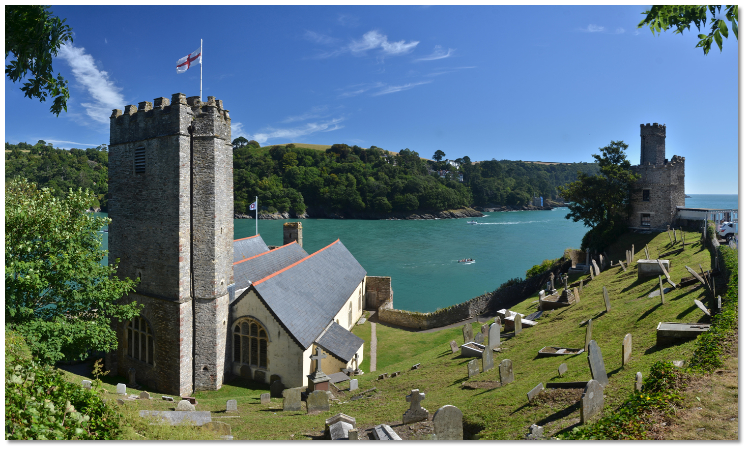 St. Petrox Church and Dartmouth Castle perched above the mouth of the river
Image: Michael Harpur
Dartmouth Castle had a Second World War blockhouse added and the town's strategic importance ensured that it was extensively bombed. The town was a major base for American forces in the latter part of the war. It was one of the departure points for Utah Beach sending 485 ships across to Normandy for the D-Day landings. After the war, the port of Dartmouth declined in terms of commercial shipping and it has largely adapted itself to the growth of tourism that its beauty generates.
 Dartmouth with the castle in the backdrop
Image: Michael Harpur
It is rare for a town to combine a rich and interesting history with present-day beauty and Dartmouth is a perfect example of this. With the castle at the furthest point of the cliff, and its gabled houses many of which are ancient, clawing their way up the steep hillside in tiers from the shore, it has to be one of the loveliest sights in Devon on a sunny day. Exploring its warren of narrow, sometimes cobbled, streets and winding steps is a step back in time. It is unsurprising that the oldest part of town, Bayards Cove, has been used for filming for decades with some of its seagoing classics including movies such as Kidnapped and the BBC's Onedin Line, while The French Lieutenant's Woman was partly filmed on the opposite side at Kingswear. Escaping industrialisation turned out to be Dartmouth's major asset today.
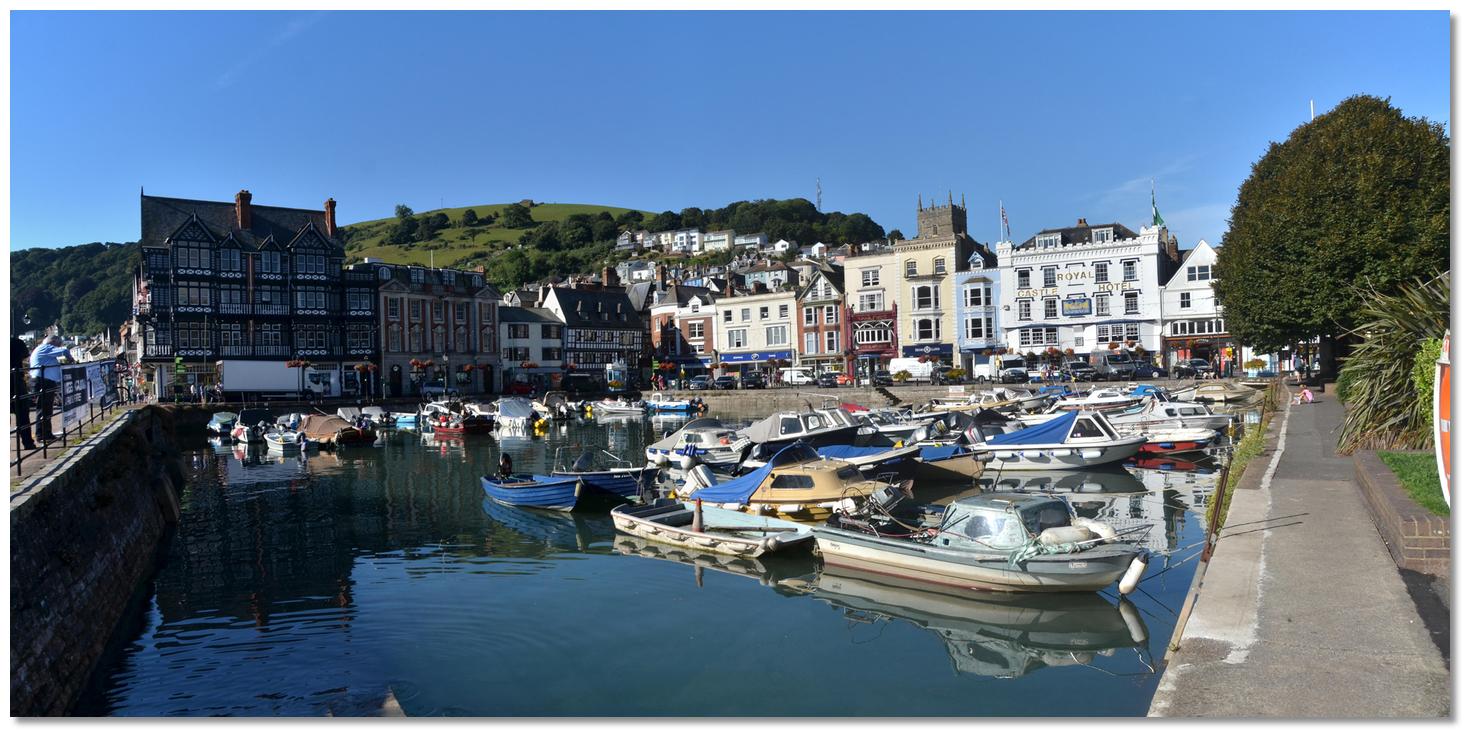 The Boatfloat harbour
Image: Michael Harpur
One of the best remaining ancient buildings is the timber-framed Butterwalk, dating from 1635 and rich with enigmatic carvings, which now houses the little Dartmouth Museum and is a must see on a visit to the town. Higher Street’s 14th-century Cherub Inn was once a few steps above the lapping tide.
 The Butterwalk Dartmouth
Image: Herbythyme via CC ASA 4.0
A short distance away, the commanding views over the river mouth from Dartmouth Castle and St. Petroc's Church, which was attached in 1641, are also a must visit. The attachment hole for the chain which once protected the entrance is still present at Kingswear Castle and remnants of the hoist still exist at Dartmouth Castle. But it is not all about history and the vibrant and historic naval town is host to a wide variety of food and music festivals, royal regattas, arts and crafts as well as theatre shows. There is something going on all year round with the annual August Bank Holiday Regatta its centrepiece event. For those looking for a beach to keep the family happy will find them in the coves on either side of the entrance. The western coves become shaded by the cliffs during the afternoon but Newfoundland Cove, on the eastern side, which has no outlying rocks faces the sun for most of the day.
 A traditional trawler in Dartmouth Harbour today
Image: Public Domain
From a boating point of view, it is is an uncomplicated all-weather harbour that can be relied upon to provide excellent shelter. It makes an ideal coastal hop or a convenient midway stepping stone for a Portland to Plymouth run or vice versa. It also is an ideal location from which to cross the Channel with Guernsey being about 70 miles from Dartmouth, and the coast of North Brittany about 90 miles due south. The River Dart itself is one of the most beautiful rivers on the south coast and is navigable at any tide up to pretty Dittisham village and on the flood for eight miles to Totnes Quay. It has extensive facilities, provisioning and connections for crew changeovers.
What facilities are available?
Water supplies for visiting vessels are available on the Dart Harbour waste pontoon midriver andTown Jetty - hoses not supplied. Apart from at marinas, the town jetty is the only other location where electricity is available.
Public showers are available at the North Embankment in the public toilets in Mayor’s Avenue car park. Dartmouth Yacht Club on the South Embankment also has shower/toilet facilities and a bar/restaurant. Royal Dart Yacht Club at Kingswear also permit the use of their facilities. The marinas all have the first-rate facilities that would be expected. Darthaven Marina has a large scale and extensively stocked chandlery. It also has a 35-tonne travel hoist along with a wide range of engineering services.
The Fuel barge is located midriver, south of the Higher Ferry and close to the main channel. The fuel barge can be contacted on VHF Ch. 6, [Dart Crusader] or M: +44 7801 798861. Diesel and unleaded petrol available but not 24 hours.
All waste from vessels in Dartmouth must be disposed of using bins provided on the waste pontoon. This is located midstream upriver of the fuel barge and has the capacity to recycle a variety of waste types.
The town is connected by two car ferries and several foot passenger ferries with Kingswear on the opposite bank.
With thanks to:
eOceanic_england_NIC_3108_stitch.jpg)
Dartmouth, Devon, England
Image: eOceanic thanks Michael Harpur
_england_NIC_2818.JPG)
Dartmouth Harbour
Image: eOceanic thanks Michael Harpur
_england_geograph_1966870_by_Neil_Theasby.jpg)
Royal Dart Yacht Club
Image: eOceanic thanks Neil Theasby via CC BY-SA 2.0
_england_NIC_2832.JPG)
Dartmouth Yacht Club
Image: eOceanic thanks Michael Harpur
_england_NIC_2834_stitch.jpg)
Dartmouth Yacht Club Pontoon
Image: eOceanic thanks Michael Harpur
_england_NIC_5983.JPG)
Darthaven Marina
Image: eOceanic thanks Michael Harpur
_england_NIC_6019.jpg)
Darthaven Marina's Travel Hoist
Image: eOceanic thanks Michael Harpur
_england_NIC_2844_stitch.jpg)
Town Jetty
Image: eOceanic thanks Michael Harpur
_england_NIC_2906.JPG)
Town Jetty
Image: eOceanic thanks Michael Harpur
_england_NIC_2933.JPG)
Boat float
Image: eOceanic thanks Michael Harpur
_england_NIC_3101.JPG)
DC Visitors Pontoon
Image: eOceanic thanks Michael Harpur
_england_NIC_2981.JPG)
Dart Marina
Image: eOceanic thanks Michael Harpur
_england_NIC_3024.JPG)
Noss on Dart Marina upriver
Image: eOceanic thanks Michael Harpur
_england_NIC_2713.jpg)
Noss on Dart Marina
Image: eOceanic thanks Michael Harpur
Dartmouth Harbour aerial overview
About Dartmouth Harbour
Dartmouth gets its name from its Celtic river-name 'Dart' combined with the Old English word mütha, meaning 'mouth of the River Dart'. The river's name, occasionally spelt 'Darant', is said to have the Celtic meaning 'river where oak trees grow' due to the banks of the lower Dart being covered in ancient woods of native oak.
A berth that is steeped in maritime historyImage: Michael Harpur
Though the Celts and Saxons would have used the excellent natural harbour to establish themselves, they only built primitive settlements on the river banks and the surrounding hills. These would have been used to defend themselves from the marauding attacks of the Vikings and neither Dartmouth nor Kingswear are mentioned in Doomsday (1088). The only local settlement that Doomsday noted was Dunestal a nearby hilltop agricultural settlement around a church which became the present Townstal and part of the current parish of Dartmouth. The seafront area at this time was probably a small scattered collection of houses used by fishermen. Kingston, situated on the plateau above Kingswear about a mile to the east, is believed to have come from Saxon times with some evidence of Stone Age and Roman occupation.
William II Norman king of England (1087 - 1100)Image: Public Domain
The name Dartmouth was first applied to the river mouth but from the early 13th-century onwards was given to the town that formed a little less than a mile within and on the west bank. This resulted from the coalescence of two small fishing hamlets of Hardness, on the north side, and Clifton on the south, that had come to establish themselves on the riverbank. These were originally separated by a tidal creek which ran well back inland and filled at high tide. This was dammed around the area of Foss Street which served to join the two settlements and created the deep ‘Mill Pool’ which powered two grain mills. In 1342 the town was incorporated by a charter frequently confirmed by later sovereigns.
Warfleet todayImage: Neil Theasby via CC BY-SA 2.0
By this time the town of Dartmouth had grown considerably and its rich merchants were wealthy on the wine trade. In 1373 Geoffrey Chaucer visited and among the pilgrims in his Canterbury Tales he noted…
For ought I wost, he was of Dertemouthe.
Geoffrey ChaucerImage: Public Domain
Hawley proved to be an excellent privateer and not only did the agreement provide for untold wealth the services of Hawley and his followers served to protect the Devon shores from French invasion. Hawley was elected mayor of Dartmouth a total of 14 times, and also served twice as the town's MP and it was he who arranged for the first Dartmouth Castle to be built. So, somewhat hand in hand with the crown, Dartmouth became a major base for privateering. And during the 14th and 15th centuries, when there was a regular trade with Bordeaux and Brittany, complaints of piracy by Dartmouth men were frequent.
Dartmouth Castle in 1794Image: Public Domain painting by Paul Sandby
This also made the town a target for reprisals and in 1485 a royal grant was given for the walling of the town and the stretching of a chain across the river mouth. Dartmouth Castle then took on the imposing and well-preserved 'gun tower' with walls 2 metres thick, one of the first designed to withstand cannon impact. It was also the very first fortification in Britain purpose-built to mount 'ship-sinking' heavy cannon. Dartmouth's only wharf was then the relatively small Bayard's Cove at the southern end of the town which was well within the firing range of the fort. Kingswear Castle, at Godmerock, was then built opposite, in 1502, enabling a 230-metre chain between the two to be raised so as to close off the river. The castle would play a prominent part and was captured by both the royalists and parliamentarians in the Civil War.
Sir Humphrey Gilbert c.1584Image: Michael Harpur
As late as 1830 the trade of this town, arising from the Newfoundland fishery, employed about 3000 men in Dartmouth which had about 350 vessels involved in its trade, both in catching the fish and in carrying them. When the catch was cured they were taken to most part to ports in the Mediterranean, and the returning vessels would bring home, wine, oil, fruit, and salt. A number of ships are also employed in the pilchard fishery. Alongside this was an extensive shipbuilding industry that had built up to service the activity.
A traditional trawler leaving the harbour in 1880Image: Public Domain
This was Dartmouth's engine of growth from the 16th-century through to the 18th-century. During this time Dartmouth developed into a significant trading port and many buildings of that era still exist within the town today. The surviving 17th-century Butterwalk in Duke Street is one fine example. The Pilgrim Fathers would have used this when they put into Dartmouth's Bayard's Cove, en route from Southampton to America. Alongside this trade, contact with these new colonies expanded and by the 18th-century locally-made goods were traded with Newfoundland, whilst salted cod was sold to Spain and Portugal in exchange for wine. The town continued to thrive and expand with further reclamation of land from the river and 1825 a decision was taken to fill in the Mill Pool to accommodate Dartmouth’s growing population.
Dartmouth and Kingswear in 1880Image: Public Domain
But at this time the town went into precipitous decline on account of being largely disconnected from the developments of the industrial revolution. Steamships replaced the sailing ships that were traditionally built in the town, and local hand weavers lost their jobs. When the Newfoundland Fishing trade also collapsed in the mid-19th century, the town faced a serious economic downturn. The precipitous and difficult terrain then delayed the coming of the railway and when it finally arrived, in 1864 to Kingswear, Dartmouth resorted to becoming a bunkering port. A planned railway never reached Dartmouth so industrialisation never arrived. In 1863 the Royal Navy decided to train naval cadets on the Dart and moored two ships in the river for the purpose.
Kingswear today as seen from Dartmouth CastleImage: Michael Harpur
Towards the end of the 19th-century, the old wharves and slips along the river bank were becoming increasingly unsuitable for the larger ships of the Victorian era and a completely new waterfront comprising the North and South Embankments was constructed and opened in 1885. This waterfront was extended in the 1930s up to the Higher Ferry which involved the reclamation of a large area of mudflats that became Coronation Park. But the quays were far from pleasant. Coal lumpers were members of gangs, who competed to bunker the ships by racing to be first to a ship. This led to the men living as close as possible to the river and their tenements became grossly overcrowded creating slum conditions. Some houses had up to 15 families in one house, one family to a room.
Britannia Royal Naval CollegeImage: Herbythyme via CC ASA 4.0
Aided by government grants, the council made a start on clearing the slums in the early part of the 20th-century. The decline in the use of coal as a fuel for ships reduced resistance to the move. The slums were demolished, and the inhabitants were rehoused to the west of Townstal. The naval training was also thought to require grander plans in the Edwardian era. On a hill above the town overlooking the river and from the designs of Sir Aston Webb, notable for designing the facade of Buckingham Palace, stands the flamboyant Britannia Royal Naval College which was opened in 1905.
St. Petrox Church and Dartmouth Castle perched above the mouth of the riverImage: Michael Harpur
Dartmouth Castle had a Second World War blockhouse added and the town's strategic importance ensured that it was extensively bombed. The town was a major base for American forces in the latter part of the war. It was one of the departure points for Utah Beach sending 485 ships across to Normandy for the D-Day landings. After the war, the port of Dartmouth declined in terms of commercial shipping and it has largely adapted itself to the growth of tourism that its beauty generates.
Dartmouth with the castle in the backdropImage: Michael Harpur
It is rare for a town to combine a rich and interesting history with present-day beauty and Dartmouth is a perfect example of this. With the castle at the furthest point of the cliff, and its gabled houses many of which are ancient, clawing their way up the steep hillside in tiers from the shore, it has to be one of the loveliest sights in Devon on a sunny day. Exploring its warren of narrow, sometimes cobbled, streets and winding steps is a step back in time. It is unsurprising that the oldest part of town, Bayards Cove, has been used for filming for decades with some of its seagoing classics including movies such as Kidnapped and the BBC's Onedin Line, while The French Lieutenant's Woman was partly filmed on the opposite side at Kingswear. Escaping industrialisation turned out to be Dartmouth's major asset today.
The Boatfloat harbourImage: Michael Harpur
One of the best remaining ancient buildings is the timber-framed Butterwalk, dating from 1635 and rich with enigmatic carvings, which now houses the little Dartmouth Museum and is a must see on a visit to the town. Higher Street’s 14th-century Cherub Inn was once a few steps above the lapping tide.
The Butterwalk DartmouthImage: Herbythyme via CC ASA 4.0
A short distance away, the commanding views over the river mouth from Dartmouth Castle and St. Petroc's Church, which was attached in 1641, are also a must visit. The attachment hole for the chain which once protected the entrance is still present at Kingswear Castle and remnants of the hoist still exist at Dartmouth Castle. But it is not all about history and the vibrant and historic naval town is host to a wide variety of food and music festivals, royal regattas, arts and crafts as well as theatre shows. There is something going on all year round with the annual August Bank Holiday Regatta its centrepiece event. For those looking for a beach to keep the family happy will find them in the coves on either side of the entrance. The western coves become shaded by the cliffs during the afternoon but Newfoundland Cove, on the eastern side, which has no outlying rocks faces the sun for most of the day.
A traditional trawler in Dartmouth Harbour todayImage: Public Domain
From a boating point of view, it is is an uncomplicated all-weather harbour that can be relied upon to provide excellent shelter. It makes an ideal coastal hop or a convenient midway stepping stone for a Portland to Plymouth run or vice versa. It also is an ideal location from which to cross the Channel with Guernsey being about 70 miles from Dartmouth, and the coast of North Brittany about 90 miles due south. The River Dart itself is one of the most beautiful rivers on the south coast and is navigable at any tide up to pretty Dittisham village and on the flood for eight miles to Totnes Quay. It has extensive facilities, provisioning and connections for crew changeovers.
Other options in this area
Click the 'Next' and 'Previous' buttons to progress through neighbouring havens in a coastal 'clockwise' or 'anti-clockwise' sequence. Alternatively here are the ten nearest havens available in picture view:
Coastal clockwise:
Dittisham & The River Dart - 1.6 miles NNWHallsands - 4.6 miles SSW
Kingsbridge - 5.5 miles WSW
Salcombe - 6.7 miles SW
Starehole Bay - 7.1 miles SW
Coastal anti-clockwise:
Brixham - 2.6 miles NNEPaignton - 3.3 miles N
Torquay - 4.3 miles N
Hope Cove (Tor Bay) - 4.9 miles NNE
Anstey’s Cove - 5.1 miles NNE
Navigational pictures
These additional images feature in the 'How to get in' section of our detailed view for Dartmouth Harbour.


| Detail view | Off |
| Picture view | On |
Dartmouth Harbour aerial overview
Add your review or comment:
Please log in to leave a review of this haven.
Please note eOceanic makes no guarantee of the validity of this information, we have not visited this haven and do not have first-hand experience to qualify the data. Although the contributors are vetted by peer review as practised authorities, they are in no way, whatsoever, responsible for the accuracy of their contributions. It is essential that you thoroughly check the accuracy and suitability for your vessel of any waypoints offered in any context plus the precision of your GPS. Any data provided on this page is entirely used at your own risk and you must read our legal page if you view data on this site. Free to use sea charts courtesy of Navionics.