

In northerly winds, the shore to the south of the harbour offers a good anchorage. Likewise, the sheltering walls of the harbour may serve in an emergency. St. Austell Bay is to the largest part clear of obstructions, making daylight access straightforward in all conditions that the anchorage is serviceable.

Keyfacts for Par
Facilities


Nature


Considerations
Protected sectors

Approaches

Shelter
Last modified
February 9th 2019 Summary
A good location with straightforward access.Facilities
Nature
Considerations
 Ch.12 [Par Port Radio]
 Position and approaches

Expand to new tab or fullscreen
Haven position
 50° 20.602' N, 004° 42.052' W
This is the head of Port of Par Breakwater.
What is the initial fix?
The following Par Initial Fix will set up a final approach:
 50° 19.950' N, 004° 41.892' W


What are the key points of the approach?
Offshore details are available in southwestern England’s coastal overview from Start Point to Lizard Point 
- Gribbin Head daymark clearly defines the eastern extremity of St. Austell Bay.
- The approached through St. Austell Bay is clear of any dangers 300 meters out from the shore.
- Stand well off the north shoreline from Par Harbour to Fishing Point as the Spit Rocks ledge extends out 300 metres.
Not what you need?
Click the 'Next' and 'Previous' buttons to progress through neighbouring havens in a coastal 'clockwise' or 'anti-clockwise' sequence. Below are the ten nearest havens to Par for your convenience.
Ten nearest havens by straight line charted distance and bearing:
- Polkerris - 0.8 nautical miles ESE
- Charlestown - 2.2 nautical miles WSW
- Fowey - 2.6 nautical miles E
- Lantic Bay - 3.8 nautical miles ESE
- Mevagissey - 5.4 nautical miles SW
- Portmellon - 5.8 nautical miles SSW
- Gorran Haven - 7 nautical miles SSW
- Polperro Harbour - 7.1 nautical miles E
- Looe Harbour - 9.6 nautical miles E
- The River Fal - 14.2 nautical miles WSW
These havens are ordered by straight line charted distance and bearing, and can be reordered by compass direction or coastal sequence:
- Polkerris - 0.8 miles ESE
- Charlestown - 2.2 miles WSW
- Fowey - 2.6 miles E
- Lantic Bay - 3.8 miles ESE
- Mevagissey - 5.4 miles SW
- Portmellon - 5.8 miles SSW
- Gorran Haven - 7 miles SSW
- Polperro Harbour - 7.1 miles E
- Looe Harbour - 9.6 miles E
- The River Fal - 14.2 miles WSW

Chart

What's the story here?
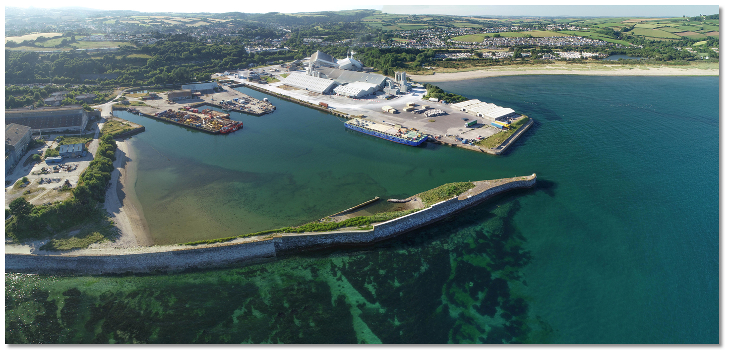 Port of Par
Image: Michael Harpur
The small drying harbour of Par is situated at the western side of Par Sand, ¾ of a mile to the northwest of Polkerris and in the northeast part of Tywardreath Bay. Formed by two piers, the harbour basin has three quays that all dry at low water. The harbour closed to commercial traffic in 2009 when a new £250 million Par Marina, boatyard and waterfront development featuring shops, cafes & restaurants was planned for the site. But this planned development has yet to materialise in any tangible form. The harbour is operated by the French mineral extraction company Imerys. Today the St Austell Bay Boat Club use the harbour's slipway facilities.
A good anchorage is available to the southwest of the harbour in any northerly component winds. A vessel surprised by a southerly may be able to enter the harbour to avail of the southerly protection its long breakwater provides, provided they can dry alongside its piers when the tide is away.
When operational the Port of Par supported vessels carrying up to 3.4 metres draft during neaps and vessels with drafts up to 5.2 metres at HWS. However, since sluicing and dredging ceased many years ago the harbour has started to silt up. So these depths may no longer be available. St Austell Bay Boat Club may have better information and can be contacted via their web site
 . Alternatively, contact the port authority for guidance 12/16 [Par Port Radio].
How to get in?
 Port of Par with the east end of the
 Spit Rocks ledge just visible
Image: Michael Harpur
 Use southwestern England’s coastal overview from Start Point to Lizard Point for seaward approaches. The prominent Gribbin Head, the eastern extremity of St. Austell Bay, makes the best seamark for Tywardreath Bay. It may be easily recognised by a conspicuous square beacon tower 26 metres high, with red and white horizontal stripes, which stands 104 metres above high water.
  Little Gribbin Point with the daymark still visible
Image: Steve Cottrell via CC ASA 4.0
St. Austell Bay is largely clear of dangers and a path that stands 300 meters out from the shore clears all of them. Stand well off Little Gribbin Point as rocks extend nearly 200 metres off this point. Par can be identified by several conspicuous chimneys and the industrial buildings connected to the dock.
At the head of Tywardreath Bay are the flats of the drying Par Sands. At the lowest tides, the sand dries out to the Killyvarder Rocks, which lie a ⅓ of a mile southeast. About 300 metres in extent, and covered at one-third flood, the Killyvarder Rocks dry to 2.4 metres and are marked by an unlit starboard beacon on their western extremity.
Image: Michael Harpur
The 2 metres contour lies about 300 metres southwestward of the Killyvarder Rocks beacon. The primary danger is a rocky ledge called the Spit Rocks that extends southwestward from the breakwater. It extends out 300 metres from Spit Point, southward of the western side of the disused industrial area, where the Bream Rocks dry to 3.4 metres. It remains foul out to 200 metres for a ⅓ of a mile westward to Fishing Point. The 2-metre contour will be found about 50 metres or less from the ledge.
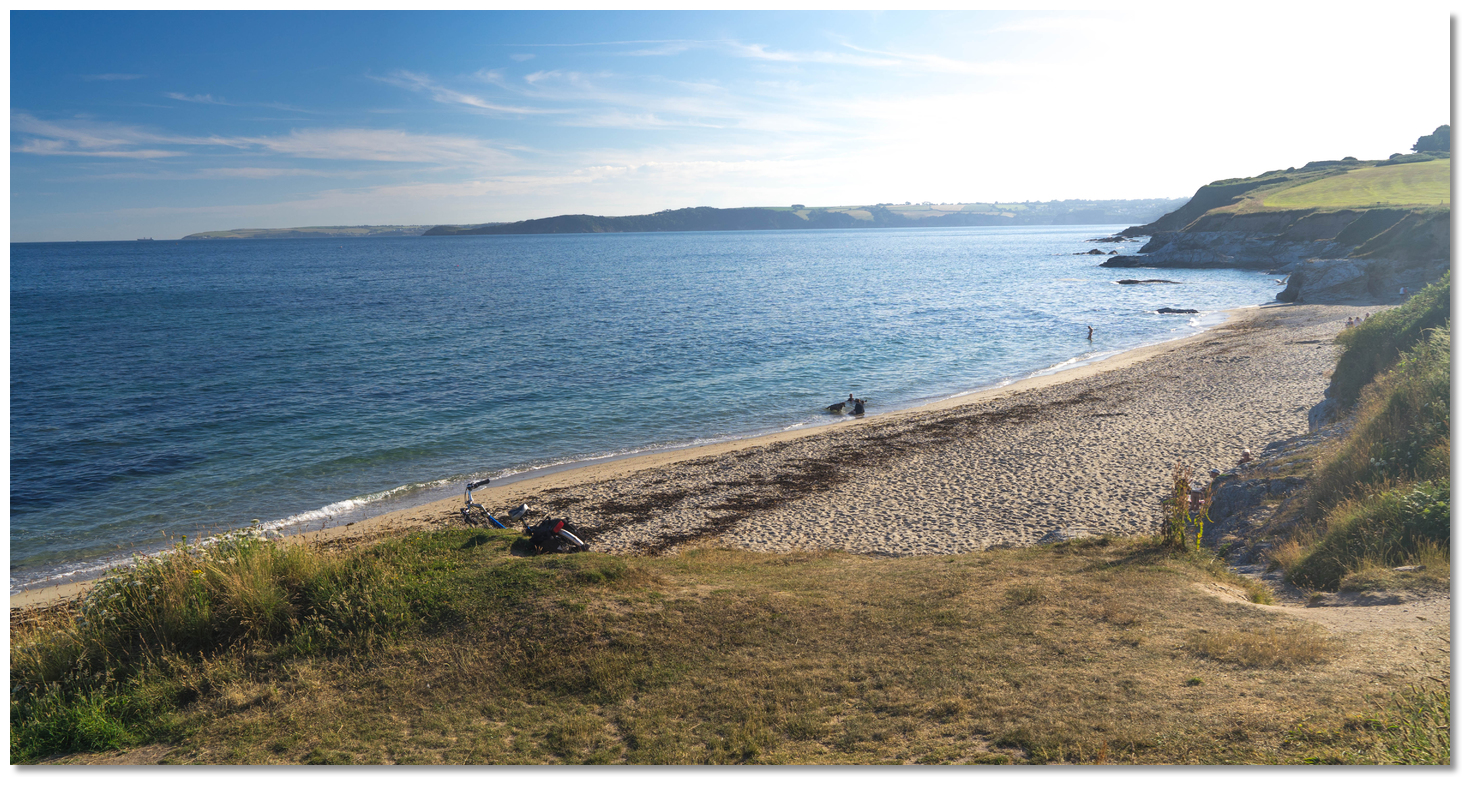 Beach at Spit Point
Image: Michael Harpur
Anchor off according to draft and conditions. Land on the beach at high water.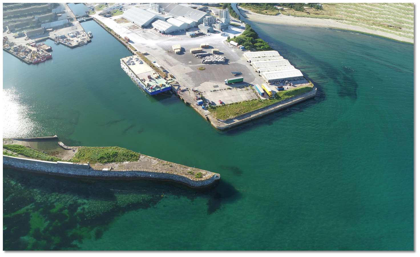 The east facing entrance of the Port of Par
Image: Michael Harpur
Should an emergency occur and a vessel needs to find shelter in the harbour, approach when sufficient draft is available. The entrance is east facing and 38 metres wide and the quays of the harbour generally dry to about 1.5 metres. Come alongside where feasible.
Why visit here?
Par, first recorded as Le Pare in 1573, derives its name from the Cornish porth, meaning creek, cove or harbour. This would have no doubt have described the flat-bottomed valley of the river mouth, that until the 16th-century was the estuary of the River Par, and which was provided with a natural breakwater by the Spit Rocks. The silted-up river valley, now drained and developed, still leads down to the harbour through West Par. Treffry Viaduct in the Luxulyan valley
Image: Mary Williams, Treffry Viaduct, Luxulyan, Cornwall via CC BY-SA 2.0
He soon began the construction of the Par Canal and Par Harbour, or Porth as it was called then, and later the Cornwall Mineral Railway. Alongside all of this activity, the industrialised settlement of Par quickly followed, and St Blazey expanded into the size of a small town. By 1835 the canal was complete and Par Harbour was fully operational, with its own blacksmiths, ship repairers, lime kilns, coal wharves, timber pickling pits, smelting works, and later a flour mill. China clay, mainly for use in papermaking, became the dominant traffic, as copper working declined in the area.
 Par Harbour in the 19th-century
Image: Public Domain
The vast drying area of Par Sands that lie to the east of Par Docks and China Clay Works, is also the result of centuries of mineral extraction above St. Austell. The flat beach is made up of fine silt that washed down over the last two centuries. Part of the sand dune system behind is a local nature reserve, and there is also a pleasant family-friendly council-owned beach that never gets overcrowded. There is also another small beach at Spit Point west of the harbour.
 Par Harbour today
Image: Michael Harpur
Between these two beaches, the South West Coast Path takes walkers inland to the small village of Par. The village is just 2 miles from the now internationally famed Eden Project which is easily reached on foot via the lush greenery of the Luxulyan Valley.
 The domes at the Eden Project
Image: Jürgen Matern via CC BY-SA 2.5
From a sailing point of view, the industrial buildings connected to the dock are somewhat incongruous within the natural beauty of St. Austell Bay. But this is a good anchoring area in offshore winds with ample interests ashore to explore and enjoy.
What facilities are available?
Par lies in a triangle of streets which form a one-way traffic system. There is a variety of shops, a post office, a public house and other businesses. St Austell Bay Boat Club slip in the harbour provides safe launching and retrieval at HighrWater ± 2.5 hours.Par has a mainline train station with frequent trains from London to Penzance. It also serves the Newquay branch line, connecting up with many of the smaller towns in Cornwall. First’s Bus route 101 connects St Austell train station with the Eden Project.
With thanks to:
eOceanicAerial vies of Par


Add your review or comment:
Please log in to leave a review of this haven.
Please note eOceanic makes no guarantee of the validity of this information, we have not visited this haven and do not have first-hand experience to qualify the data. Although the contributors are vetted by peer review as practised authorities, they are in no way, whatsoever, responsible for the accuracy of their contributions. It is essential that you thoroughly check the accuracy and suitability for your vessel of any waypoints offered in any context plus the precision of your GPS. Any data provided on this page is entirely used at your own risk and you must read our legal page if you view data on this site. Free to use sea charts courtesy of Navionics.