

The cove provides tolerable shelter in moderate conditions from the south, round through west to north. Positioned in the southwest end of a bight, with one above water rock complex, the approach is straightforward during daylight.

Keyfacts for Gorran Haven
Facilities


Nature


Considerations

Protected sectors

Approaches

Shelter

Last modified
February 27th 2019 Summary* Restrictions apply
A tolerable location with straightforward access.Facilities
Nature
Considerations
Position and approaches

Expand to new tab or fullscreen
Haven position
 50° 14.452' N, 004° 47.186' W
This is the pierhead at Gorran Haven
What is the initial fix?
The following Gorran Haven Initial Fix will set up a final approach:
 50° 14.497' N, 004° 46.850' W


What are the key points of the approach?
Offshore details are available in southwestern England’s coastal overview from Start Point to Lizard Point 
- Vessels visiting Gorran Haven will be obliged to pass inside Gwineas Rocks where ample space will be found.
- Keeping 400 metres off the headlands of the coastal bight, and on a tidal adjusted 5-metre contour, clears all dangers in the approaches.
Not what you need?
Click the 'Next' and 'Previous' buttons to progress through neighbouring havens in a coastal 'clockwise' or 'anti-clockwise' sequence. Below are the ten nearest havens to Gorran Haven for your convenience.
Ten nearest havens by straight line charted distance and bearing:
- Portmellon - 1.3 nautical miles N
- Mevagissey - 1.7 nautical miles N
- Charlestown - 5.5 nautical miles NNE
- Par - 7 nautical miles NNE
- Polkerris - 7 nautical miles NE
- Portscatho - 7.9 nautical miles WSW
- Fowey - 8.2 nautical miles NE
- Lantic Bay - 8.7 nautical miles NE
- Saint Mawes - 10.1 nautical miles WSW
- The River Fal - 10.1 nautical miles W
These havens are ordered by straight line charted distance and bearing, and can be reordered by compass direction or coastal sequence:
- Portmellon - 1.3 miles N
- Mevagissey - 1.7 miles N
- Charlestown - 5.5 miles NNE
- Par - 7 miles NNE
- Polkerris - 7 miles NE
- Portscatho - 7.9 miles WSW
- Fowey - 8.2 miles NE
- Lantic Bay - 8.7 miles NE
- Saint Mawes - 10.1 miles WSW
- The River Fal - 10.1 miles W

Chart

What's the story here?
 Gorran Haven
Image: Michael Harpur
Gorran Haven is a small fishing village situated due west of Gwineas Rocks and in the bight that opens between Chapel Point and Pen-a-maen. The harbour is nestled into a sandy cove between high sloping cliffs in the southwest corner of the bight. The cove is protected from the southeast by an 'L' shaped pier.
The granite pier and the harbour behind it dries to a flat sand beach at low water. At or near high water it is possible to berth alongside the inside wall of the pier which has 1.8 metres at MHWS. Stout fenders will be required, or ideally a fender board, as the historic quay's wall is rough. Finding space alongside may prove challenging as local boats occupy most of the space behind the quay.
The best option is to dry out on the sands behind it. Alternatively, anchor off 100 to 500 metres east-northeast of the pier. Portmellon, on the north side of Church Point, offers slightly better anchorage and Gorran Haven is at its best as an anchorage in winds from west or northwest.
How to get in?
 Gorran Haven Quay
Image: Michael Harpur
 Use southwestern England’s coastal overview from Start Point to Lizard Point for seaward approaches.
 Gwineas Rocks as seen off Turbot Point
Image: Michael Harpur
The only possible danger is Gwineas Rock that lies ¾ of a mile outside the coastal bight in which Gorran Haven is situated. The highest point of the rock complex is 8 metres above high water springs and is black in appearance. A particularly dangerous eastern outlier called The Yaw lies 200 metres from Gwineas Rock and it dries to 0.9 metres at the lowest tides. 300 metres to the southeast of Yaw Rock and on the seaward side of the group is the lit ‘Gwineas’ east cardinal buoy, Q(3)10s.
 Gwineas Rocks as seen over Gorran Haven Quay
Image: Michael Harpur
Vessels visiting Gorran Haven will be obliged to pass inside Gwineas Rocks which have ample space. The inshore bay is ½ a mile wide and has a depth of 6 to 14 metres.
 Gorran Haven to Turbot Point
Image: Michael Harpur
 Vessels approaching from the north should stand at least 300 metres off Chapel Point after which Gwineas Rock, located less than ¾ of a mile south should be visible. After Turbot Point, south of Chapel Point, keep out 250 to 300 metres off the shore or stay outside the 5-metre contour, tidal corrected, continuing down to the Gorran Haven Initial Fix.
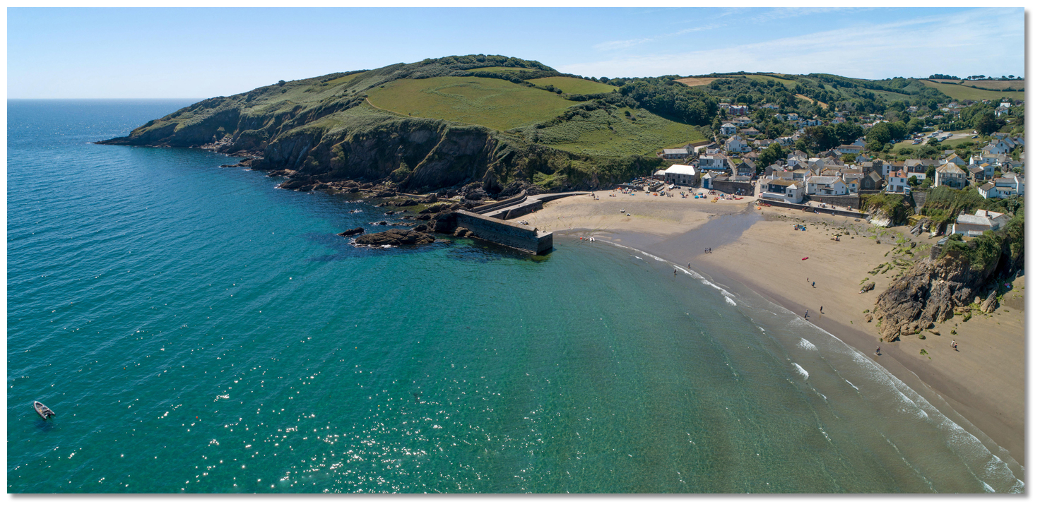 Gorran Haven to Pen-a-maen
Image: Michael Harpur
 Vessels approaching the south should note there is a recognised tidal race off Dodman Point. Give the approaches to Pen-a-maen at least 400 metres clearance. This is to avoid the off-lying group of rocks, called Curran Vean, which cover at one-quarter flood and extend about 200 metres off the approaches to the Point. The 5-metre contour lies north of Pen-a-maen and it is safe to follow this north, or steer for the Initial fix.
 Foul ground around the pier
Image: Michael Harpur
 From the initial fix sound in westward to an appropriate depth. The bottom is clean, gently shelving sand all the way in. Keep well clear of the pier as its southern side is surrounded by a rocky reef.
  Local boats at Gorran Haven Quay
Image: Michael Harpur
Anchor outside the harbour east by northeast of the pierhead. Or dry out inside, either alongside or on the hard flat sands behind. Land by tender at the quay.Why visit here?
Gorran Haven received its name in the late 18th or early 19th century from its patron Saint Guron, or Goronus, who came here from Bodmin to form a new settlement in this area. The early Cornish name for Gorran Haven was 'Porth Ust', a corruption of 'Porth-Just', which meant 'St Just's Cove'. Over time this got corrupted to 'Porthust', by which it is still known as in Cornish meaning ‘Point East’. Stain glass window Gorran Haven
 Image: Paul de Gregorio via CC BY-SA 2.0
The Christian naming connections extend to its fronting Gwineas Rocks which may have been the site of a hermitage of an early saint. Its name is derived from the old Cornish 'Gwyn-enys' meaning white or holy island. Many suggest this is the St. Just that the cove and the medieval church in the village are dedicated to. The church dates back to 1475 when it was known as 'Porth-Just'. The wealth that built it came from its fishermen who came here to pray and used it as a landmark to guide them safely home.
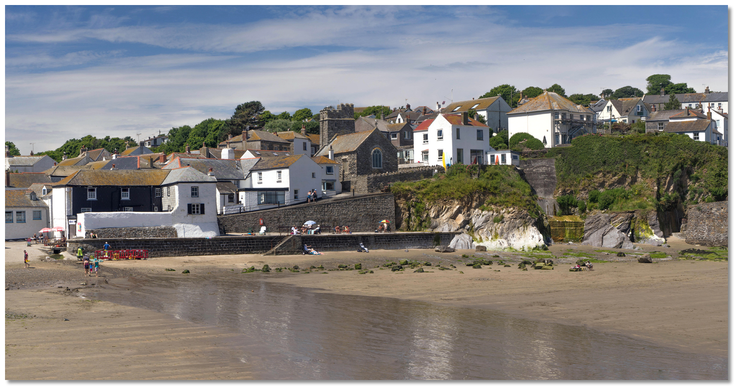 The church today overlooking the sandy cove
Image: Michael Harpur
Fishing was something that the cove excelled in since ancient times. One of the first records of seining in England, the catching of pilchards with long nets, in relation to the village occured here in 1270. Its first pier was built by the local landowning Bodrugan family, whose name is commemorated in the farmstead of Bodrugan Barton, above Chapel Point. They backed the wrong king during the 'Wars of the Roses' and after the decisive 1485 'Battle of Bosworth' they had to flee. Where they set off for France, near Turbot Point and a short distance from the beautiful Colona Beach, became known to this day as 'Bodrugan's Leap'.
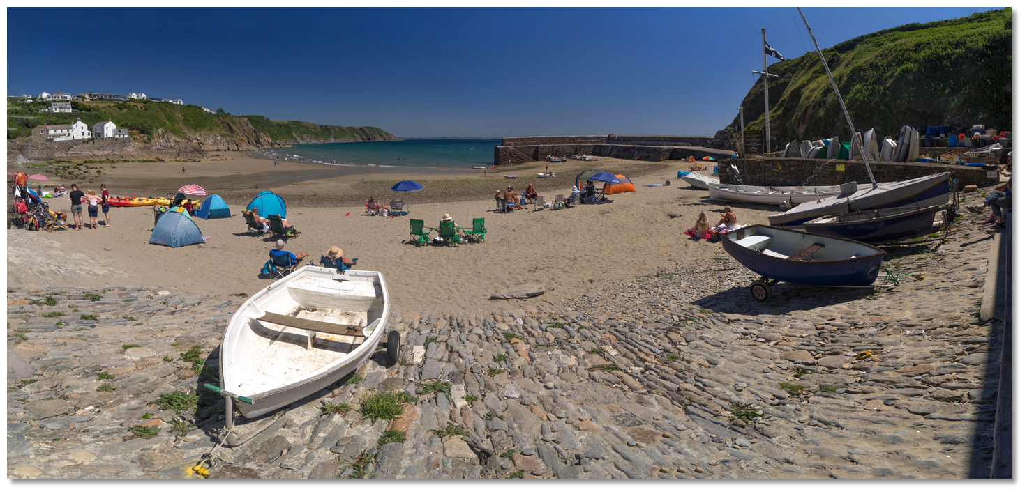
 Local boats behind the 'L' shaped quay
Image: Michael Harpur
The pretty little church of St Just also fell on hard times on account of the Tudor dynasty that established itself in the battle. After Henry VIII's break with Rome it was one of the private chapels known as chantries, that was seized by the Crown and sold off in 1568. One of its subsequent secular roles included use as a fisherman's store, or fish cellar, which was used for over a century. It is often referred to as the old Chapel Cellar.
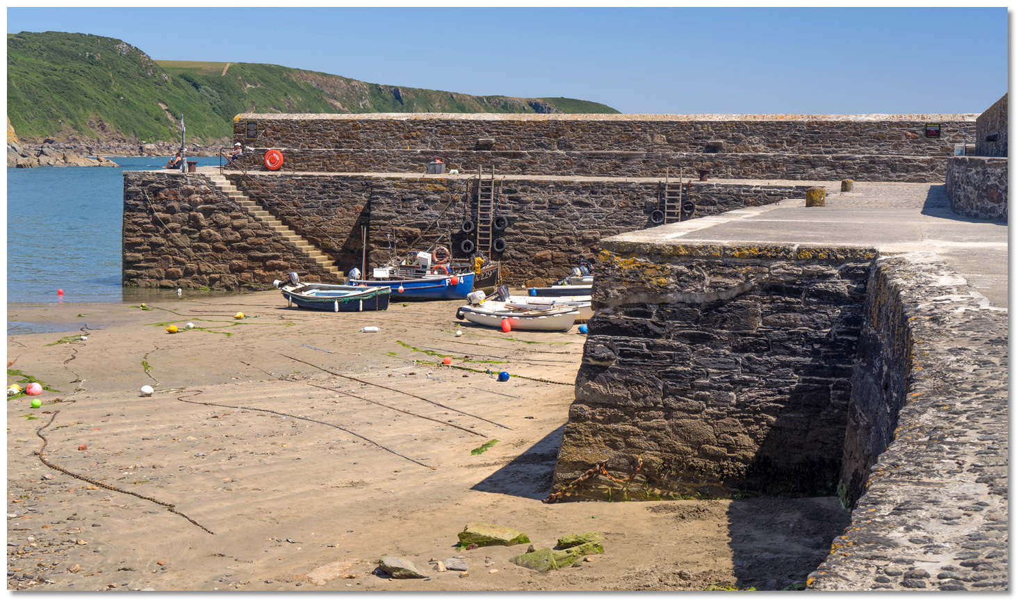 The masonry of Gorran Haven's Quay dates back to an 1886 rebuild
Image: Michael Harpur
But Bodrugan's investment in Gorran Haven proved wise and it was in its day a far more important fishing centre than Mevagissey. The first record of fishing in the area dates back to 1570 when it recorded Gorran Haven as having a community of 68 fishermen. The same record noted that Mevagissey had only 8. It was not until the introduction of drift nets in the 18th-century that Mevagissey became dominant.
 Fishermen's crane at the head of the quay
Image: Michael Harpur
In the 18th and 19th-centuries, Gorran Haven also handled merchandise brought in from Fowey by barges and lighters. The pier was rebuilt in the 1820s but in the early part of the 19th-century, the harbour experienced a downturn and its quay was neglected and fell into ruin. The present quay was rebuilt in 1886 to support a local industry of crab and lobster fishing that lasted into the early part of the 20th-century. After that, the harbour became largely residential, with many people retiring here.
 The view from the head of the beach
Image: Michael Harpur
Its old centre with its harbour, comprising a cluster of cottages and two churches, largely remains intact and is today protected as a Conservation Area. The harbour still has six fishing boats, from 3 to 4 metres, that use nets and pots from spring through to autumn, and fishermen may also handline for mackerel. Gorran Church Town, a mile inland from the beach atop a hill, and clustered around its church has broad streets and large houses that appear somewhat removed from the smelly business of fishing, but its central feature remains connected to the sea. Of Norman origin, the Church of St. Goran has a 33-metre high 15th-century tower designed to be an important landmark as seen from the sea.
 Gorran Haven's old fishermen houses and its overseers of the sea
Image: Michael Harpur
Being located in a remote location and with narrow rural roads as access, the harbour has remained largely intact and almost entirely unspoilt. Gorran has a quiet rural pace of life, and the friendliness of the community is appreciated by both inhabitants and visitors alike.
 Vault Beach which is also known as Bow Beach
Image: Michael Harpur
The cove is split between two sandy beaches, Vault Beach which is also known as Bow Beach to the south of Gorran Haven and Great Perhaver Beach to the north. They are rarely overwhelmed and are usually used by families who rent cottages and who return year after year. Much of the surrounding area is designated an Area of Outstanding Natural Beauty and the South West Coast Path here is truly spectacular.
 The South West Coast Path leading out to Pen-a-maen
Image: Michael Harpur
From a boating point of view, it is a good fairweather location for the coastal cruiser with one of Cornwall’s most attractive coastal villages ashore.
What facilities are available?
A freshwater tap can be found in the boat compound. There is a beach shop, toilets and pubs in the village.With thanks to:
eOceanicGorran Haven Aerial


Add your review or comment:
Please log in to leave a review of this haven.
Please note eOceanic makes no guarantee of the validity of this information, we have not visited this haven and do not have first-hand experience to qualify the data. Although the contributors are vetted by peer review as practised authorities, they are in no way, whatsoever, responsible for the accuracy of their contributions. It is essential that you thoroughly check the accuracy and suitability for your vessel of any waypoints offered in any context plus the precision of your GPS. Any data provided on this page is entirely used at your own risk and you must read our legal page if you view data on this site. Free to use sea charts courtesy of Navionics.