
_stitch.jpg)
Keyhaven is situated immediately within the Western Solent to the north of Hurst Point off the south coast of England. Located behind a protective shingle bar, it is a nature reserve of saltings and mudflats that dries to channels at low water. These host lines of private moorings that, if unattended, may be picked up by visiting boats. It is also possible to anchor just inside the entrance, and moderate draft vessels can take to the hard alongside the quay.
Keyhaven’s small and well enclosed channels provide very good seaway protection but little air protection. Access is over a bar that almost dries at LWS and although marked the haven requires attentive navigation as it can be difficult to identify its marks from seaward and there is no room for error.


Keyfacts for Keyhaven


Last modified
July 17th 2018 Summary* Restrictions apply
A good location with attentive navigation required for access.Facilities


Nature


Considerations


Enquiries  +44 1590 645695 [River Warden]
  Ch.37 [River Warden]
+44 1590 645695 [River Warden] Ch.37 [River Warden] Position and approaches

Expand to new tab or fullscreen
Haven position
 50° 42.720' N, 001° 33.297' W
This is the first of the deeper water moorings within the entrance.
What is the initial fix?
The following Keyhaven Initial fix will set up a final approach:
 50° 42.802' N, 001° 32.520' W


What are the key points of the approach?
The entry and the run-up thorough The Solent and Southampton Water are covered in
The Solent and Isle of Wight coastal description.
The Solent and Isle of Wight
coastal description.- Time the approach, typically 2 hours each side of HW, to attain a sufficient rise to cross Keyhaven’s sandbar.
- Approaches should be outside the yellow race buoy to avoid the shallows extending out from Pennington Spit.
- Identify the entrance’s small port and starboard marks and align a course of 309°T until this alinement can be picked out by its narrow leading marks.
- Pass between the port and starboard buoys then swing hard to port around a second port buoy situated off North Point.
- Follow the starboard channel marker buoys immediately inside the entrance and then the lines of moorings buoys further within.
- Anchor immediately within the entrance, pick up a mooring or continue in at high water to dry out at the quay.
Not what you need?
Click the 'Next' and 'Previous' buttons to progress through neighbouring havens in a coastal 'clockwise' or 'anti-clockwise' sequence. Below are the ten nearest havens to Keyhaven for your convenience.
Ten nearest havens by straight line charted distance and bearing:
- Hurst Road - 0.3 nautical miles SE
- Totland Bay - 1.9 nautical miles S
- Yarmouth - 2.1 nautical miles E
- Lymington Yacht Haven - 2.7 nautical miles NNE
- Lymington - 2.7 nautical miles NNE
- Alum Bay - 2.7 nautical miles SSW
- Berthon Lymington Marina - 2.9 nautical miles NNE
- Freshwater Bay - 3.2 nautical miles SSE
- Scratchell's Bay - 3.3 nautical miles SSW
- Newtown River Entrance - 5.5 nautical miles E
These havens are ordered by straight line charted distance and bearing, and can be reordered by compass direction or coastal sequence:
- Hurst Road - 0.3 miles SE
- Totland Bay - 1.9 miles S
- Yarmouth - 2.1 miles E
- Lymington Yacht Haven - 2.7 miles NNE
- Lymington - 2.7 miles NNE
- Alum Bay - 2.7 miles SSW
- Berthon Lymington Marina - 2.9 miles NNE
- Freshwater Bay - 3.2 miles SSE
- Scratchell's Bay - 3.3 miles SSW
- Newtown River Entrance - 5.5 miles E


How to get in?

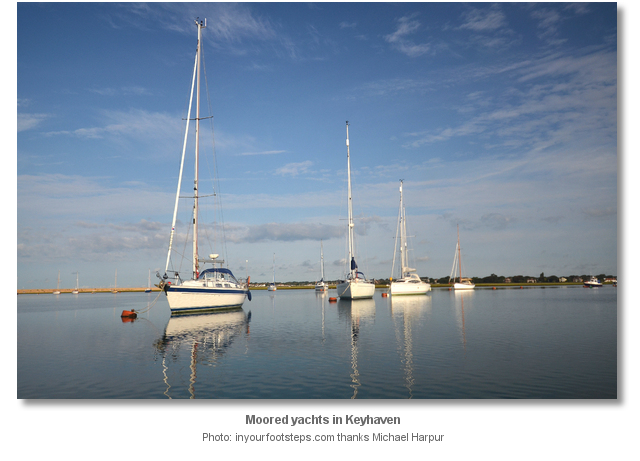
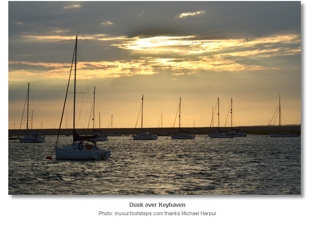
Keyhaven is a tiny hamlet with a small quay from which a handful of fishing boats operate. It lies within the borders of the New Forest National Park and is fronted by Keyhaven Lake a 2,000 acre reserve of saltings and mudflats. Although the creek presents a large body of water at high tide it dries to channels congested with private moorings at low water. Visitors should expect space to be very tight and to have little in the way of air cover.
The primary focus of navigation for accessing Keyhaven Lake is to attain sufficient draft to cross its sandbar. The bar is situated close inside its North Point entrance and is marked by small and unlit port and starboard entrance buoys. The depth on the bar can be taken to be chart datum so tidal heights provided by standard tide tables will represent the actual depth that can be expected over the bar.
Entry is normally restricted to 2 hours each side of HW. However deeper vessels operating on the margins should come in on the rise and especially so on Springs. Keyhaven benefits from a double high water and a long four hour stand on or around Springs. However, during these times, the ebb whistles out of the haven in a shortened amount of time. As such, in the event of any grounding, a vessel will have a maximum of 5 minutes to get off so there is little room for error. It is therefore essential to have no confusion about the tides. Those planning a visit here should make certain the predictions relied upon are for ‘high water’ and not the ‘middle of the stand’.

The sweetspot vessel size for Keyhaven is 10 m / 32 ft. and 1.2 metres draft, bilge or lifting keel even better. Vessels of this size and draft, or less, can freely come in on the appropriate rise and pick up moorings. Anything larger or deeper would benefit from the advice of the Keyhaven River Warden VHF 37/M1 or P1 or P: +44 1590 645 695 to see if accommodation can be made.
Do not however be put off if a vessel is larger than the sweetspot size as it is well worth making enquires with the River Warden. They could not be more helpful and they made light work of our survey vessel. At 14 m / 46 ft. LOA 1.8 draft this was at the top end of Keyhaven’s capability. However they accommodated it rafted up alongside a vessel on the second mooring inside, immediately within the entrance, and just above the first bend.
Newcomers should entirely avoid approaching Keyhaven in any developed easterly conditions. The creek is one of a very few private rivers in the world and charges will be applied in all cases, either anchored or moored up. As the channels are narrow and it has little air protection it is advisable to make use of a mooring.

 The Solent and Isle of Wight coastal description provides approach details from seaward.
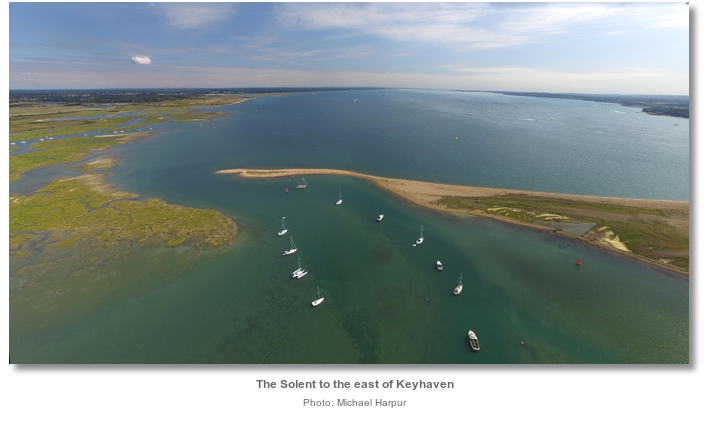
 Vessels approaching from the east should not let Hurst Point light bear less than 230° T. This is to avoid the Pennington Marsh shallows. These are located in the area between the entrance to Lymington and Hurst Point and their shallow waters extend out ¾ of a mile from the shore.
 From the initial fix the entrance is half a mile east-by-northeast. With a sufficient rise of tide, and a keen eye on the sounder, proceed westward from here, searching for Keyhaven’s low-lying entrance that can be difficult to identify.
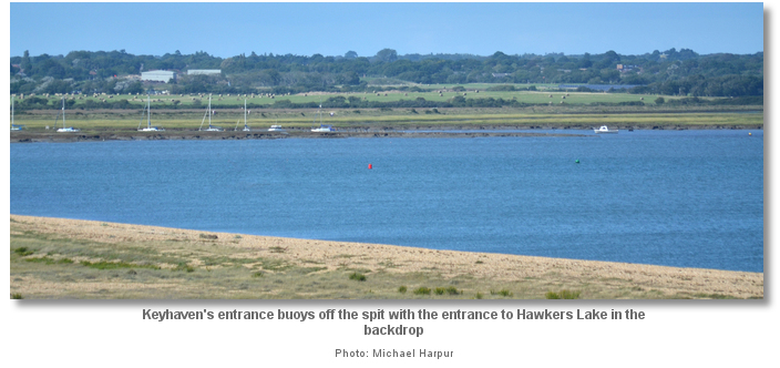
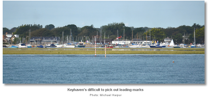
The entrance lies at the head of a shingle bank that extends about half a mile northwest of the conspicuous Hurst Point light. Although the entrance has leading marks they are difficult to see. Positioned on the mudflats, close inside the entrance, the very narrow marks are difficult to pick out from the buildings and yacht rigs in the backdrop.
The entrance’s small port and starboard marks, although small, will most likely show themselves long before the leading marks. Once they have been identified continue westward until their centre point bears 309°T then steer for the entrance between them. Closer in, then the two leading red and white striped alignment posts will be seen marking the transit of 309°T.
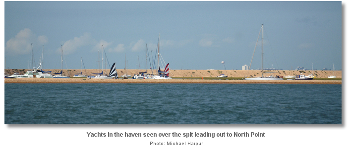
Once they are identified, keep in transit and proceed to the buoys marking the entrance between North Point’s low shingle bank and mudflats to the north. The low sand and shingle promontory leading out to North Point should now be seen to stand out against the background of yachts within the haven. On final approaches, the helmsman should prepare for strong tides across entrance, particularly on the ebb.

Once through the buoys slowly continue until a second port hand red buoy, Keyhaven’s only illuminated mark Fl(3) 9s, off North Point is abeam to port. Then turn hard to port circling half a boat length around this buoy until steering south-westward and passing along inside face of the shingle spit. The channel within the entrance has pools with depths of 4.1 to 2.3 metres with depths gradually decreasing to the quay at Keyhaven which only remains accessible by tenders at low water.

The best water within the entrance will be found passing close to starboard of the three small green buoys immediately within the entrance. These lead to the start of a chain of mooring buoys that best describe the centre-lines of Keyhaven’s channels beyond. There is a 4 knot speed limit inside the haven.

From this point on, after starboard marks No. 5 to 6, it is best to steer along the lines of private mooring buoys. Keyhaven’s starboard channel marks are set on the edges of the channel and often catch out vessels on bends where the shallows can curve out beyond a straight line described by a pair of starboard marks.
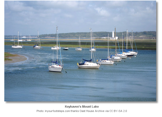
By contrast, the mooring buoys are set centre-channel with short chains thereby describing the deep waters of the channel. It is, however, essential to pass the heads of the moored boats and never to pass astern. Keyhaven’s channels can be as narrow as 10 metres wide, especially in Mount Lake, and passing astern of a boat could place a vessel on the outside margin of the channel.

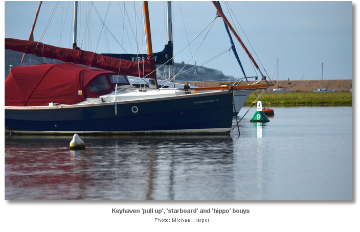
The mooring buoys also indicate the depth that can be expected within the channels. Mount Lake and the long Reach’s orange ‘hippo’ buoys indicate at least a metre LWS. The ‘pull up’ moorings in the ‘short reach’ and beyond mark the transition to shallower waters.
 The only anchorage in Keyhaven is immediately inside the entrance. It is situated in a very small pool located between North Point and the first set of moorings, close to the spit on the port side. After this, it is a matter of picking up moorings or rafting up as directed by the River Wardens.
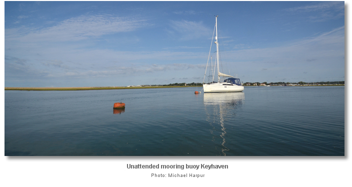
Keyhaven has no dedicated visitor moorings. Vessels up to 10 m / 32 ft. and 1.1 metres or less draft, can freely pick up unattended private moorings provided there is tender attached and it is an unlikely time for the owner to return. Large vessels should berth as directed by the River Warden who will most likely come out to assist.
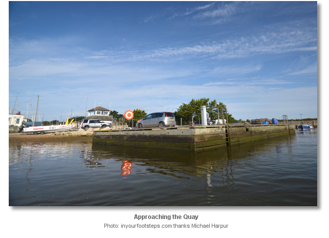
1.8 metres can be had all the way up to the Quay at high water. The Quay’s southeast corner is for loading and unloading with a 20-30 minute time restriction. Vessels of 10 m / 30 ft. or less are welcome to come alongside the quays northern face and dry out for the night. The southern face is for scrubbing.
As Keyhaven is a private river, charges will be made for all berthing arrangements, be they alongside, on a mooring or on anchor within the entrance.
Landings can be made at the Quay that is accessible by tender at all stages of the tide. On the south side of the inlet, land on the shingle beach leading out to North Point. English Heritage does not allow the ‘Camber’ channel nor its jetty to be used by boatmen as this interrupts their ferry service. Those intending to visit Hurst Castle should land on the shingle beach and walk down the shoreline.
Hurst Castle ferries will act as a tender and pick up boatmen and land them either at the castle or at the quay as required for a fee. They can be reached on VHF Ch 74.

Why visit here?
Keyhaven derives its name from Old English words ‘cū’plus hæfen. ‘cū’ in Old English means ‘cow’ and hæfen ‘safety’, the origin of ‘haven’. The name therefore means ‘Harbour where cows are shipped’. It is believed that it was historically a point of transportation for cattle and sheep, to and from, the Isle of Wight.Keyhaven and the Pennington saltmarsh and mud flats both came into being as a result of the sheltering arm of Hurst Spit. The spit was formed from loose flint pebbles which had been eroded from the cliffs further west. The protection of the natural barrier beach and the marshes behind have led to thousands of years of human activity.

Keyhaven was a port as early as 1206 and a considerable salt industry developed here in the Middle Ages. The valuable salt was made by impounding seawater in shallow lagoons, known as salterns, where it was then left to evaporate. The industry had died out in Keyhaven by the 15th century but was revived in the 17th century when new techniques increased production efficiencies. These included wind pumps that drew off and pumped brine solution into especially constructed boiling houses. Here the brine was heated on large metal pans until the water evaporated and only the salt remained. Alongside the boiler houses were a series of narrow docks constructed in the marshes. These enabled sailing barges to import coal, required to heat the brine, and export the resultant salt. But, by 1865, cheaper mined salt from Cheshire rendered the process uneconomical and salt production finally came to an end in Keyhaven.
Up until recent times Keyhaven was a fishing village but fishing has fallen into gradual decline for a period of years. The village’s main draw now is tourism for its history, nature reserve and sailing. Much of the tourism is driven by the unique Hurst Castle that guards the Solent from the southern end of its Hurst Spit.

England was politically isolated in 1538 after Henry VIII's divorce of Catherine of Aragon. The resulting hostility between France and Spain aroused fears of invasion and Henry VIII commenced the construction of the Device Forts to defend England’s southern coast. The chain of artillery fortifications, also known as the Henrician Castles, were financed from the proceeds of the dissolution of the monasteries and represented England's largest defence programme since Saxon times. Hurst Castle, that was said to have some of Beaulieu Monasteries' stone, was completed in 1544 and is thought to be the most sophisticated of the chain of coastal fortresses. Not only was the formidable castle perfectly sited on the Solent narrow entrance, three-quarters of a mile wide, but the strong tidal ebb and flow here would put any would-be invader fleet entirely at its mercy.

All these adaptations and extensions have made it the largest coastal fort in the world. During the Second World War it took on quick-firing gun batteries and searchlights. However, after World War II, Hurst Castle was finally decommissioned. This finally brought to an end 412 years of continuous military use. During this entire period, akin to all The Solent's mighty eighteenth century fortress, Hurst was never put to the test.

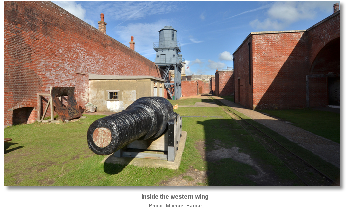
Hurst Castle is now an English Heritage site open to the public. Two of the huge 38-ton guns installed in the 1870s can be viewed in their casemants together with early cannon and other weapons. Hurst Castle also carried several lighthouses with the first one erected here as far back as 1786. Today this tradition is carried on by a lighthouse museum that can be visited within its western wing.
From a sailing perspective Keyhaven is more suited to medium sized and draft vessels working a visit in around the tides. However larger boats can be accommodated with some diligence and the assistance of the river wardens. The remarkable Hurst Castle itself makes it a worthwhile destination, and the pretty little Hamlet of Keyhaven should not be overlooked. The large body of enclosed water makes it an ideal location to let youngsters off sailing, canoeing and exploring.

What facilities are available?
Water is available from the tap at the back of the quay. Public toilets are available at the carpark beyond. Keyhaven Yacht Club reciprocates visitors from other clubs allowing them the use of their showers and bar which overlooks the haven. A local boatyard focuses on providing owners of leisure craft with a comprehensive and reliable set of boating services. It has a mobile crane for lifting craft ashore up to 40’ LOA and 9 tons weight, and offers winter lay-up facilities for approximately 120 yachts. Their slipway caters for vessels up to 45' LOA and 20 tons weight. The local pub provides very good hot meals.Provisions, and fuel by jerry can, are available at Milford-on-Sea a mile or 30 minutes walk away. It also has more dining opportunities, a post office, a chemist and a bank that provides a cashpoint.
Keyhaven has no public transport services. The nearest bus services and train station is at Lymington.
Any security concerns?
Never an issue known to have occurred to a vessel visiting Keyhaven.With thanks to:
Roy Plummer and Steve Wood Keyhaven River Wardens. Photography Michael Harpur.


About Keyhaven
Keyhaven derives its name from Old English words ‘cū’plus hæfen. ‘cū’ in Old English means ‘cow’ and hæfen ‘safety’, the origin of ‘haven’. The name therefore means ‘Harbour where cows are shipped’. It is believed that it was historically a point of transportation for cattle and sheep, to and from, the Isle of Wight.
Keyhaven and the Pennington saltmarsh and mud flats both came into being as a result of the sheltering arm of Hurst Spit. The spit was formed from loose flint pebbles which had been eroded from the cliffs further west. The protection of the natural barrier beach and the marshes behind have led to thousands of years of human activity.
Keyhaven was a port as early as 1206 and a considerable salt industry developed here in the Middle Ages. The valuable salt was made by impounding seawater in shallow lagoons, known as salterns, where it was then left to evaporate. The industry had died out in Keyhaven by the 15th century but was revived in the 17th century when new techniques increased production efficiencies. These included wind pumps that drew off and pumped brine solution into especially constructed boiling houses. Here the brine was heated on large metal pans until the water evaporated and only the salt remained. Alongside the boiler houses were a series of narrow docks constructed in the marshes. These enabled sailing barges to import coal, required to heat the brine, and export the resultant salt. But, by 1865, cheaper mined salt from Cheshire rendered the process uneconomical and salt production finally came to an end in Keyhaven.
Up until recent times Keyhaven was a fishing village but fishing has fallen into gradual decline for a period of years. The village’s main draw now is tourism for its history, nature reserve and sailing. Much of the tourism is driven by the unique Hurst Castle that guards the Solent from the southern end of its Hurst Spit.
England was politically isolated in 1538 after Henry VIII's divorce of Catherine of Aragon. The resulting hostility between France and Spain aroused fears of invasion and Henry VIII commenced the construction of the Device Forts to defend England’s southern coast. The chain of artillery fortifications, also known as the Henrician Castles, were financed from the proceeds of the dissolution of the monasteries and represented England's largest defence programme since Saxon times. Hurst Castle, that was said to have some of Beaulieu Monasteries' stone, was completed in 1544 and is thought to be the most sophisticated of the chain of coastal fortresses. Not only was the formidable castle perfectly sited on the Solent narrow entrance, three-quarters of a mile wide, but the strong tidal ebb and flow here would put any would-be invader fleet entirely at its mercy.
All these adaptations and extensions have made it the largest coastal fort in the world. During the Second World War it took on quick-firing gun batteries and searchlights. However, after World War II, Hurst Castle was finally decommissioned. This finally brought to an end 412 years of continuous military use. During this entire period, akin to all The Solent's mighty eighteenth century fortress, Hurst was never put to the test.
Hurst Castle is now an English Heritage site open to the public. Two of the huge 38-ton guns installed in the 1870s can be viewed in their casemants together with early cannon and other weapons. Hurst Castle also carried several lighthouses with the first one erected here as far back as 1786. Today this tradition is carried on by a lighthouse museum that can be visited within its western wing.
From a sailing perspective Keyhaven is more suited to medium sized and draft vessels working a visit in around the tides. However larger boats can be accommodated with some diligence and the assistance of the river wardens. The remarkable Hurst Castle itself makes it a worthwhile destination, and the pretty little Hamlet of Keyhaven should not be overlooked. The large body of enclosed water makes it an ideal location to let youngsters off sailing, canoeing and exploring.
Other options in this area
Click the 'Next' and 'Previous' buttons to progress through neighbouring havens in a coastal 'clockwise' or 'anti-clockwise' sequence. Alternatively here are the ten nearest havens available in picture view:
Coastal clockwise:
Hurst Road - 0.2 miles SEChristchurch Bay - 4.1 miles W
Christchurch Harbour - 5.2 miles W
Salterns Marina - 9.4 miles W
Parkstone Yacht Club - 9.5 miles W
Coastal anti-clockwise:
Lymington Yacht Haven - 1.7 miles NNEBerthon Lymington Marina - 1.8 miles NNE
Lymington - 1.7 miles NNE
Gull Island - 4.6 miles ENE
Gins Farm - 4.3 miles NE
Navigational pictures
These additional images feature in the 'How to get in' section of our detailed view for Keyhaven.


| Detail view | Off |
| Picture view | On |
Add your review or comment:
Please log in to leave a review of this haven.
Please note eOceanic makes no guarantee of the validity of this information, we have not visited this haven and do not have first-hand experience to qualify the data. Although the contributors are vetted by peer review as practised authorities, they are in no way, whatsoever, responsible for the accuracy of their contributions. It is essential that you thoroughly check the accuracy and suitability for your vessel of any waypoints offered in any context plus the precision of your GPS. Any data provided on this page is entirely used at your own risk and you must read our legal page if you view data on this site. Free to use sea charts courtesy of Navionics.