
Tucked away within the inner harbour, the anchorage offers good protection. The area is however severely windswept and the inner harbour so vast that it can only offer protection to westerly winds. In all other conditions, Portland Marina may be relied upon for a good night. Safe access is available night or day, at any stage of the tide and in all reasonable conditions.


Keyfacts for Small Mouth
Facilities


Nature


Considerations

Protected sectors

Approaches

Shelter

Last modified
July 18th 2018 Summary
A good location with safe access.Facilities
Nature
Considerations
HM  +44 1305 824044
  Ch.74 [Portland Harbour Radio]
+44 1305 824044 Ch.74 [Portland Harbour Radio] Position and approaches

Expand to new tab or fullscreen
Haven position
 50° 35.100' N, 002° 27.610' W
This is in a depth of about 3 metres CD about 800 metres out from Small Mouth.
What is the initial fix?
The following Portland Harbour East Ship Channel will set up a final approach:
 50° 35.680' N, 002° 25.745' W


What are the key points of the approach?
Offshore details are available in the westbound  or eastbound sequenced 'Selsey Bill to Start Point' coastal description. Approaches to the area are provided in the Weymouth Harbour entry and approaches to Portland Harbour are covered in the Portland Marina entry.
or eastbound sequenced 'Selsey Bill to Start Point' coastal description. Approaches to the area are provided in the Weymouth Harbour entry and approaches to Portland Harbour are covered in the Portland Marina entry.Not what you need?
Click the 'Next' and 'Previous' buttons to progress through neighbouring havens in a coastal 'clockwise' or 'anti-clockwise' sequence. Below are the ten nearest havens to Small Mouth for your convenience.
Ten nearest havens by straight line charted distance and bearing:
- Portland Marina - 0.7 nautical miles SSE
- Weymouth Harbour - 1.4 nautical miles NNE
- Weymouth Marina - 1.5 nautical miles N
- Church Ope Cove - 3.1 nautical miles SSE
- Ringstead Bay - 5.4 nautical miles ENE
- Durdle Door - 7.3 nautical miles ENE
- Lulworth Cove - 8.4 nautical miles ENE
- Worbarrow Bay - 9.3 nautical miles ENE
- West Bay (Bridport) - 13.8 nautical miles WNW
- Wareham - 14.6 nautical miles ENE
These havens are ordered by straight line charted distance and bearing, and can be reordered by compass direction or coastal sequence:
- Portland Marina - 0.7 miles SSE
- Weymouth Harbour - 1.4 miles NNE
- Weymouth Marina - 1.5 miles N
- Church Ope Cove - 3.1 miles SSE
- Ringstead Bay - 5.4 miles ENE
- Durdle Door - 7.3 miles ENE
- Lulworth Cove - 8.4 miles ENE
- Worbarrow Bay - 9.3 miles ENE
- West Bay (Bridport) - 13.8 miles WNW
- Wareham - 14.6 miles ENE

Chart

How to get in?

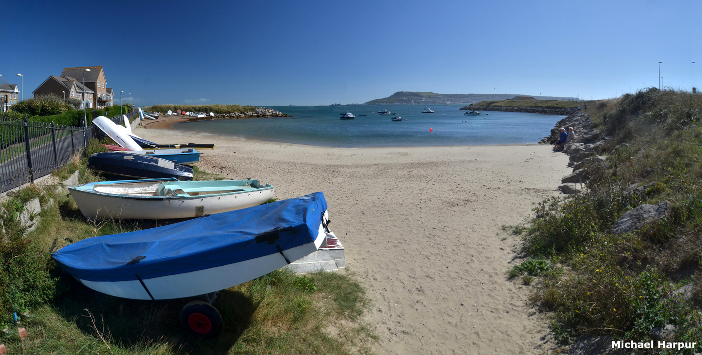
Portland Harbour is located on the northeast side of the Portland Peninsula. The harbour is protected by four vast breakwaters within, where there is a limited amount of areas available for yachts to anchor. These are all on the north-west side of the inner harbour, off Castletown, Sandsfoot Castle and the Small Mouth. The former two are allocated to the local yacht clubs and individuals on a permanent basis, so most visitors anchor off Small Mouth.

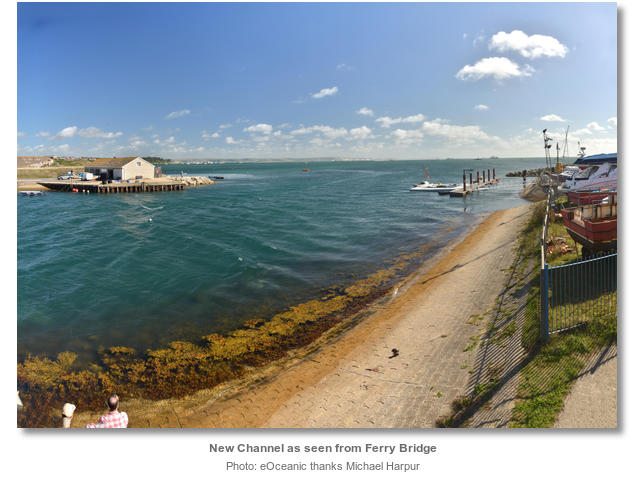
The Small Mouth anchorage is located about a ½ mile east by northeast from where Ferry Bridge joins the Isle of Portland to the mainland. This is situated at the north end of the narrow causeway, formed by Chesil Beach, where the New Channel joins the enclosed East Fleet into the harbour.
The harbour authority requests that all visiting yachts, including anchoring vessels, ask permission before entering or leaving the harbour area. They may be contacted on VHF Ch. 74 [Portland Harbour Radio] or P: +44 1305 824044.

 Approaches to the area are provided in the Weymouth Harbour entry and approaches to Portland Harbour are covered in the Portland Marina entry. From the North Ship Channel follow the marina entry instructions to the safe water mark where the channel turns south.
Break off at the Safe Water Mark, Iso, 10s, and steer towards the New Channel beacon L.F 1s3m5M, located eastward of the bridge. The inner harbour area is generally deep, but it shelves towards its western boundaries, which can be shallow and dry out up to a ¼ of a mile from the shore. When approaching midway between the marks, turn westward and sound into a preferred depth.
 Anchor according to draft clear of any local moorings. There is plenty of room to anchor and the sand and mud holding is excellent. However, this is an ancient anchorage and mooring ground so a trip line is essential.
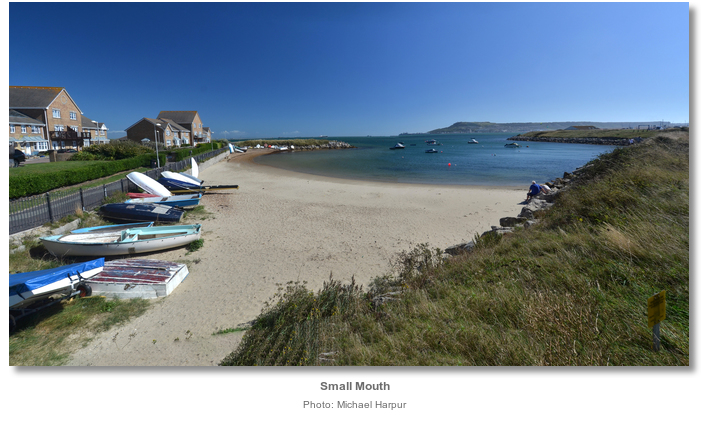
Land by tender at the sandy beach at Small Mouth or further south on Small Mouth Sands' shale beach beneath the café.

Visitor moorings may be had by arrangement with the Royal Dorset Yacht Club P: +44 1305 786258, E: info@royal-dorset.com or Castle Cove Sailing Club P: +44 1305 783708. Ferrybridge Marine Service moorings, P: + 44 1305 777350 marked ‘FMS’, will be seen in the vicinity of New Channel beacon.
Why visit here?
In 1866 the Lancastrian born engineer Robert Whitehead successfully demonstrated a practical torpedo design for the Austrian Imperial Naval commission. It would lead to the first successful commercial torpedo factory to be built above the Smallmouth Beach overlooking the anchorage.
By 1877, the ‘Whitehead Torpedo’ was attaining speeds of 18 mph for ranges of 830 yards and it was not long before the early torpedo would soon prove how deadly it was in combat. In 1878 Russian torpedo boats sunk the Turkish ship Intibah during the Russo-Turkish War. Most of the world's major navies took note and dually placed their orders with the Whitehead factory based in Fiume - now Rijeka in Croatia. By the late 1880s, almost all of the navies were deploying torpedo boats to carry the weapon into battle and engineers began to envisage submarines armed with Whitehead Torpedoes.
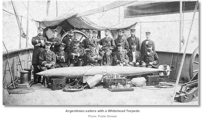
By then the early adopting British Navy was encouraging Whitehead to set up a manufacturing facility in England, threatening to cancel all orders if he did not. Portland, the base for the Channel and the Home Fleets and a depot for submarines, was where the Navy had been testing the Whitehead Torpedoes. It was the logical location for the factory and the area just above Small Mouth was purchased especially for the purpose. In April 1891, the foundation stone of Whiteheads Factory was laid down and the harbour became the centre for research into underwater warfare.

Whitehead's invention of the torpedo was a key development in naval history as it spurred on the development of submarines and then the technology to detect and destroy them. British Admiral Henry John May commented in 1904 ‘but for Whitehead, the submarine would remain an interesting toy and little more’. The advances from his factory would reshape the harbour itself leading to the two northern arms being added between 1893 and 1906 to protect the ships from submarine attack.

The old track bed of the Weymouth to Portland Railway, which closed in 1962 and passes immediately in front of the memorial, has been created into a more useful legacy for the present visitor. It has been turned into the highly convenient Rodwell Trail which is a 3km long sealed walkway into the heart of Weymouth. The car-free wildlife corridor has the 1539 Henrican Sandsfoot Castle, also historically known as Weymouth Castle, situated about midway along the pathway. The important castle was slowly collapsing into the harbour, but thanks to a 2011 Heritage Lottery Fund grant it has now been restored. Its gardens, featuring a popular café, are now open to the general public. The walk also features old station platforms and some spectacular views over Portland Harbour with Portland in the distance.

Likewise Chesil Beach, with its 180 billion pebbles stretching 18 miles to West Bay, is just a short stroll across the road, as is East Fleet, one of the most wildlife-rich lagoons in the country. Information on both can be had at The Chesil Beach Visitor Centre, a 0.8km walk along the traffic-free Portland Beach Road route, and Fortuneswell on Portland is only a further 2.3km.
From a sailing perspective, Portland Harbour’s Small Mouth anchorage has to be the most convenient quick-in, quick-out option for a passage making vessel to rest a tide before catching the next tide westward, or eastward, as the case may be. But there is plenty immediately at hand for those who want to stay over for a day or two to experience the area or those doing so on a budget.
What facilities are available?
There is little ashore except for the Chesil Beach Visitor Centre. Its Taste Café serves a selection of hot and cold food, snacks and great coffee, and is open from 10 am daily. There is also a cafe on the overlooking Small Mouth Sand. All yachting facilities can be had from Portland Marina, including, fuel, gas and water. All provisions are available from Weymouth.With thanks to:
Michael Harpur S/Y Whistler. Photography Michael Harpur and Andrew Bone.
.jpg)


Sandsfoot Castle


Add your review or comment:
Please log in to leave a review of this haven.
Please note eOceanic makes no guarantee of the validity of this information, we have not visited this haven and do not have first-hand experience to qualify the data. Although the contributors are vetted by peer review as practised authorities, they are in no way, whatsoever, responsible for the accuracy of their contributions. It is essential that you thoroughly check the accuracy and suitability for your vessel of any waypoints offered in any context plus the precision of your GPS. Any data provided on this page is entirely used at your own risk and you must read our legal page if you view data on this site. Free to use sea charts courtesy of Navionics.