

Scratchell's Bay is located off the south coast of England, on the western extremity of the Isle of Wight and immediately southeast of The Needles.
It is a remote exposed bay only suitable for a lunch stop anchorage in very settled or light northerly conditions. Access requires careful daylight ‘eye ball’ navigation to avoid its two outlying obstructions.


Keyfacts for Scratchell's Bay


Last modified
August 24th 2018 Summary
An exposed location with careful navigation required for access.Facilities

Nature


Considerations
Position and approaches

Expand to new tab or fullscreen
Haven position
 50° 39.625' N, 001° 34.982' W
This is about 200 metres north westward of Saint Anthony Rock.
What is the initial fix?
The following Scratchell's Bay initial fix will set up a final approach:
 50° 39.584' N, 001° 34.894' W


What are the key points of the approach?
The entry and the run-up thorough The Solent and Southampton Water are covered in
The Solent and Isle of Wight coastal description.
The Solent and Isle of Wight
coastal description. - Locate Saint Anthony Rock and from it the approximate position of the Irex wreck.
- Navigate past the Irex wreck and anchor according to draft.
Not what you need?
Click the 'Next' and 'Previous' buttons to progress through neighbouring havens in a coastal 'clockwise' or 'anti-clockwise' sequence. Below are the ten nearest havens to Scratchell's Bay for your convenience.
Ten nearest havens by straight line charted distance and bearing:
- Alum Bay - 0.6 nautical miles NE
- Totland Bay - 1.8 nautical miles NE
- Freshwater Bay - 2.8 nautical miles E
- Hurst Road - 3.2 nautical miles NNE
- Keyhaven - 3.3 nautical miles NNE
- Yarmouth - 4.2 nautical miles NE
- Lymington Yacht Haven - 5.9 nautical miles NNE
- Lymington - 6 nautical miles NNE
- Berthon Lymington Marina - 6.1 nautical miles NNE
- Christchurch Bay - 6.8 nautical miles NW
These havens are ordered by straight line charted distance and bearing, and can be reordered by compass direction or coastal sequence:
- Alum Bay - 0.6 miles NE
- Totland Bay - 1.8 miles NE
- Freshwater Bay - 2.8 miles E
- Hurst Road - 3.2 miles NNE
- Keyhaven - 3.3 miles NNE
- Yarmouth - 4.2 miles NE
- Lymington Yacht Haven - 5.9 miles NNE
- Lymington - 6 miles NNE
- Berthon Lymington Marina - 6.1 miles NNE
- Christchurch Bay - 6.8 miles NW


How to get in?

The western extremity of the Isle of Wight, called Needles Point, is a narrow chalky peninsula. It rises perpendicularly from the sea with jagged rocks to form high chalky cliffs. The southward facing and largest expanse of these cliffs is the precipitous Scratchell's Bay. Scratchell's Bay is 120 metres high, 400 metres long and straight with a shingle beach at its foot. A small cave is located at its eastern end of the bay, called Needles Cove, situated beneath Sun Corner.
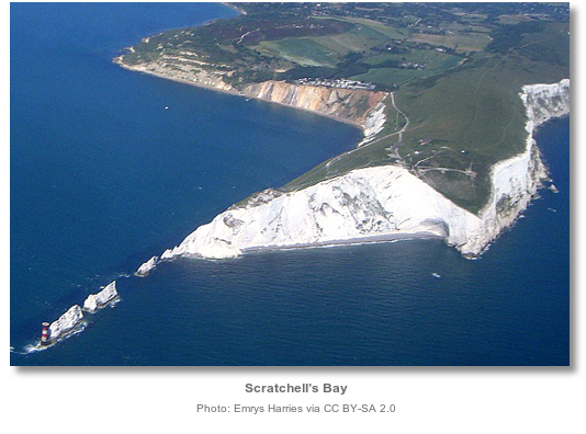
From a boating perspective Scratchell’s Bay is shallow out from the shore with its two metre contour located 250 metres from its cliff face. It is clear of obstructions except for the dangerous Saint Anthony Rock and the wreck of a 19th century iron hulled sailing ship called the Irex that sank here. The less dangerous of the two is the inshore Saint Anthony Rock that has a drying height of 0.6 metres. It is always visible or awash and usually very easy to pick out.
The outer Irex Wreck is covered by ½ a metre of water and only awash on a low spring tide. Sitting immediately outside the centre of the bay and reaching up from deep water the Irex Wreck is very dangerous for leisure craft. The key to the bay is to identify the area where the wreck is located and work around it.

 The distinctive chalk cliffs overlooking Scratchell's Bay, immediately southeast of the Needles, will most likely be the first visible point seen from seaward on a western approach.
 On closer approaches three very distinctive rocks called the Needle Rocks, with a striking red and white striped lighthouse positioned on the outermost rock, will be seen jutting out from the Needle Point.
The Needles – lighthouse Oc.(2) RWG.20s 24m 17-13M position: 50° 39.734'N, 001° 35.500'W
From the safe water ‘Whis Fairway’ Light-buoy L Fl.10s, position 2.7 mile west by southwest of the lighthouse, the two important buoys, that should be passed to port will be seen. This is the port hand ‘SW Shingles’ Light Buoy, marking the southwest end of Shingles shoal, 1½ miles northeast, and the ‘Bridge’ West Cardinal a further ½ mile northeast of that mark.
Passing south of the ‘SW Shingles Light Buoy’, and well south of the ‘Bridge’ west cardinal at Bridge Reef described below, on the approach to the initial fix clears all dangers.

 Vessels approaching from the north taking an inshore approach are cautioned against hugging the Needle's Lighthouse too close. It should be given a berth of at least 200 metres to the northwest to avoid ‘Goose Rock’ that dries at low water springs. ‘Goose Rock’ is situated about 50 metres west by northwest of the lighthouse.
 Vessels should extend that distance to at least 250 metres when rounding the lighthouse to avoid the wreck of the Varvassi located about 150 metres west by southwest from the lighthouse. The ship has broken into components that are spread out across an area 100 metres long. Vessels do cut this but the gaps cannot be relied upon as the ship’s structure is driven up and pushed around by tide and wave action. It is best to stand out.
Outside of this is The Bridge reef that extends up to three-quarters of a mile, west by south, from the Needles Rocks. It has a least depth of 5.5 metres and its western extremity is well marked by ‘The Bridge’ west cardinal buoy. It is subject to dangerous overfalls in heavy weather at all states of the tide but in moderate conditions, when Scratchell’s Bay would present an anchoring opportunity, it should present little more than tidal rips and churning water.

 Vessels approaching from the southeast will see the white chalk of Scratchell Bay’s begin to dominate the island’s eastern clays and sands at Freshwater Bay about 3 miles east of Needles Point. The chalk cliffs commence in the middle of Freshwater Bay where they are low at first and then climb magnificently.
 On the shore and at the head of the small cove of Freshwater Bay is a noticeable hotel. Tennyson’s Cross, a prominent monument, will be seen standing near the top of the cliffs, 1.2 miles west of Freshwater Bay and Scratchell Bay 1.5 westward.
Vessels that stay out in the 5 metre contour or beyond 250 metres of the cliffs will find no dangers along this coast.

 The Initial fix is set on the east side or Sun Corner side of the bay. It is on the 5 metre contour and located 100 metres south of Saint Anthony Rock. The objective of the initial fix is to set up an ‘eye ball plot’ on the Saint Anthony Rock. With this point of reference the general position of the Irex Wreck may be safely approximated and the path into the bay.
Saint Anthony Rock lies just inside the 2 metre contour, 160 metres west by southwest from Scratchell’s Bay’s Sun Corner. The Irex wreck lies along about the same line of alignment 200 metres west by southwest from Saint Anthony Rock.
Once Saint Anthony Rock has been clearly identified it is possible to pass 50 to 100 metres westward of Saint Anthony Rock safely clear of the Irex wreck that is 200 metres away from it, and then on into the bay. It is likewise safe to pass midway between Saint Anthony Rock and the Sun Corner shoreline, but some may find this daunting.
A local set of transits for those who want to more tightly define the position for the Irex wreck is to align the crown of Saint Anthony Rock with the small cave on the shore in Sun Corner’s Needles Cove. Where this line of bearing, of 085°M. intersects the line of the broken eastern dry moat wall, seen jutting out over the top of the cliff from the Old Needles Battery, of 027°M, is where the Irex wreck lies.
Vessels rounding the The Needles may likewise ignore the initial fix and follow the 2 metre contour or less along the shore until Saint Anthony Rock can be seen off Sun Corner. The area with the Irex wreck may then be approximated and avoided.
 The bay is shallow a long way out from the foot of the cliffs with the two metre contour about 220 metres out from the cliff face. Hence keel boats will only be able to come in close on neaps or the top half of the tide. There is only about 1 kn. of tide in close to the shore.
 Anchor according to draft in sand, shale and loose boulders. The boulders make it unsuitable for vessels that can take to the hard in an attempt to dry out. Land by tender on the shingle beach.
Why visit here?
Scratchell’s Bay derives its name from Old Scratch or Mr. Scratch that is used to describe the Devil. It is believed to be derived from the Middle English name scrat, the name for a demon or goblin, which itself stems from the Old Norse word skratte.
Irex was a Glasgow built, three-masted, 92 metre long steel-hulled ship that launched in October 1889. She sailed out on her maiden voyage on Christmas Eve of 1889 with a cargo of 3,600 tons of iron sewerage pipes bound for Rio de Janeiro. Shortly after departing the ship encountered furious winds and was forced to take shelter in Belfast Lough. Irex set off again on January 1st, 1890, only to caught in hurricane force conditions south of Ireland a couple of weeks later. These conditions were so bad that it forced the ship to run off up the English Channel. The captain tried to take shelter in Falmouth but was not able to secure a pilot boat and had to continue the run up the channel. Approaching the Needles, the ship’s captain then made the fatal error of mistaking the light from a pilot boat for that of the Needles Lighthouse.

At 9 a.m. the soldiers of The Needles Battery saw the wreck and alerted the Totland lifeboat. The lifeboat launched and came to the scene by noon where it was assisted by a steam collier Hampshire who had also spotted the foundering Irex and had come to offer assistance. The storm tossed seas overpower both vessels and none could come near the Irex. A large wave then smashed the lifeboat into the bow of the Hampshire and caused such damage that the lifeboat had to abandon the rescue attempt, and then had to be towed back to port by Hampshire. At 1.15 p.m. the Coastguard launched a rocket from the battery out over the wreck situated 300 metres offshore. The rocket carried a line from the shore that unfortunately got caught in the rigging. The survivors then climbed the rigging to get the line and one fell to his death in the process. The line was finally secured after two hours of courage and desperation and a hawser sent out. This finally enabled 29 survivors, from the crew of 36, to be winched by chair from the ship to the cliff-top. The Irex remains to this day the largest sailing ship to be wrecked on the Isle of Wight.
Today a leisure craft choosing to visit Scratchell’s Bay on a fine day, a very different experience can be expected. For in fine weather this is a place to drink in the bay’s immense concave recess and soaring chalky precipices in wonderment. The bold and varied outline of its chalk is made all the more beautiful by its flint-defined stratification.

On a beautiful day, the contrasting colours between a burnished blue sky, the white chalk of the bay’s magnificent imposing arch, the grey flint pebbles on the beach and crystal clear translucent waters offers a truly unique experience. The fact that it is the reserve of the cruising vessel along with the guillemots, ravens and razorbills soaring up its 120 metre cliffs, only adds to its unique appeal to stop for lunch or come ashore for a short stroll.
What facilities are available?
This is a remote bay that has no facilities except for its shingle beach on which to land.Any security concerns?
Never an issue known to have occurred to a vessel anchored off Scratchell’s Bay.With thanks to:
Peter Lemonius of Needles Pleasure Cruises who visit the bay several times a day during the season. Photography with thanks to Michael Harpur, Graham Rabbit, Barry Deakin and Christine Matthews.


About Scratchell's Bay
Scratchell’s Bay derives its name from Old Scratch or Mr. Scratch that is used to describe the Devil. It is believed to be derived from the Middle English name scrat, the name for a demon or goblin, which itself stems from the Old Norse word skratte.
Irex was a Glasgow built, three-masted, 92 metre long steel-hulled ship that launched in October 1889. She sailed out on her maiden voyage on Christmas Eve of 1889 with a cargo of 3,600 tons of iron sewerage pipes bound for Rio de Janeiro. Shortly after departing the ship encountered furious winds and was forced to take shelter in Belfast Lough. Irex set off again on January 1st, 1890, only to caught in hurricane force conditions south of Ireland a couple of weeks later. These conditions were so bad that it forced the ship to run off up the English Channel. The captain tried to take shelter in Falmouth but was not able to secure a pilot boat and had to continue the run up the channel. Approaching the Needles, the ship’s captain then made the fatal error of mistaking the light from a pilot boat for that of the Needles Lighthouse.
At 9 a.m. the soldiers of The Needles Battery saw the wreck and alerted the Totland lifeboat. The lifeboat launched and came to the scene by noon where it was assisted by a steam collier Hampshire who had also spotted the foundering Irex and had come to offer assistance. The storm tossed seas overpower both vessels and none could come near the Irex. A large wave then smashed the lifeboat into the bow of the Hampshire and caused such damage that the lifeboat had to abandon the rescue attempt, and then had to be towed back to port by Hampshire. At 1.15 p.m. the Coastguard launched a rocket from the battery out over the wreck situated 300 metres offshore. The rocket carried a line from the shore that unfortunately got caught in the rigging. The survivors then climbed the rigging to get the line and one fell to his death in the process. The line was finally secured after two hours of courage and desperation and a hawser sent out. This finally enabled 29 survivors, from the crew of 36, to be winched by chair from the ship to the cliff-top. The Irex remains to this day the largest sailing ship to be wrecked on the Isle of Wight.
Today a leisure craft choosing to visit Scratchell’s Bay on a fine day, a very different experience can be expected. For in fine weather this is a place to drink in the bay’s immense concave recess and soaring chalky precipices in wonderment. The bold and varied outline of its chalk is made all the more beautiful by its flint-defined stratification.
On a beautiful day, the contrasting colours between a burnished blue sky, the white chalk of the bay’s magnificent imposing arch, the grey flint pebbles on the beach and crystal clear translucent waters offers a truly unique experience. The fact that it is the reserve of the cruising vessel along with the guillemots, ravens and razorbills soaring up its 120 metre cliffs, only adds to its unique appeal to stop for lunch or come ashore for a short stroll.
Other options in this area
Click the 'Next' and 'Previous' buttons to progress through neighbouring havens in a coastal 'clockwise' or 'anti-clockwise' sequence. Alternatively here are the ten nearest havens available in picture view:
Coastal clockwise:
Alum Bay - 0.4 miles NETotland Bay - 1.1 miles NE
Yarmouth - 2.6 miles NE
Newtown River Entrance - 4.7 miles ENE
Newtown River - 4.8 miles ENE
Coastal anti-clockwise:
Freshwater Bay - 1.7 miles EVentnor - 9.3 miles ESE
Sandown Bay - 10.1 miles E
Whitecliff Bay - 11.6 miles E
Bembridge Harbour - 11.5 miles E
Navigational pictures
These additional images feature in the 'How to get in' section of our detailed view for Scratchell's Bay.


| Detail view | Off |
| Picture view | On |
Add your review or comment:
Please log in to leave a review of this haven.
Please note eOceanic makes no guarantee of the validity of this information, we have not visited this haven and do not have first-hand experience to qualify the data. Although the contributors are vetted by peer review as practised authorities, they are in no way, whatsoever, responsible for the accuracy of their contributions. It is essential that you thoroughly check the accuracy and suitability for your vessel of any waypoints offered in any context plus the precision of your GPS. Any data provided on this page is entirely used at your own risk and you must read our legal page if you view data on this site. Free to use sea charts courtesy of Navionics.