
_stitch.jpg)
Brighton is a seaside resort on the south coast of England situated forty miles eastward of the Isle of Wight. It is a busy cosmopolitan city that offers visiting craft a large-scale marina complex.
Brighton Marina offers complete protection from all conditions. The harbour’s well marked and the wide entrance provides safe access at all stages of tides, night and day, in all reasonable conditions except for a southeast gale. It is, however, not that deep and vessels carrying anything more than a moderate draft should check the available depth at low water.

Keyfacts for Brighton


Last modified
August 16th 2022 Summary
A completely protected location with safe access.Facilities


Nature


Considerations

 +44 1273 819919
 premiermarinas.com/uk-marina-locations/brighton-marina
 Ch.80/37
Position and approaches

Expand to new tab or fullscreen
Haven position
 50° 48.504' N, 000° 6.382' W
This is at the head of the West Breakwater that exhibits a light Q.R. 10m7M. The harbours southeast facing entrance is situated immediately to the north.
What is the initial fix?
The following Brighton Marina intial fix will set up a final approach:
 50° 48.482' N, 000° 6.304' W



What are the key points of the approach?
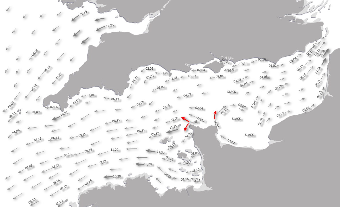
Offshore details are available in the southeast England’s Coastal Overview for North Foreland to the Isle of Wight  .
.
. - Contact the marina on final approaches.
- Moderatly deep craft should confirm the available depth in the entrance at low water.
- Keep to the west side of the entrance channel for best water.
Not what you need?
Click the 'Next' and 'Previous' buttons to progress through neighbouring havens in a coastal 'clockwise' or 'anti-clockwise' sequence. Below are the ten nearest havens to Brighton for your convenience.
Ten nearest havens by straight line charted distance and bearing:
- Newhaven - 2.7 nautical miles SE
- Shoreham - 5.5 nautical miles W
- Littlehampton - 16.5 nautical miles W
- Sovereign Harbour (Eastbourne Marina) - 16.8 nautical miles E
- Dell Quay - 27 nautical miles W
- Chichester Marina - 27.3 nautical miles W
- Birdham Pool Marina - 27.5 nautical miles W
- Bosham - 28.7 nautical miles W
- Itchenor - 28.8 nautical miles W
- Chalkdock Point - 29.2 nautical miles W
These havens are ordered by straight line charted distance and bearing, and can be reordered by compass direction or coastal sequence:
- Newhaven - 2.7 miles SE
- Shoreham - 5.5 miles W
- Littlehampton - 16.5 miles W
- Sovereign Harbour (Eastbourne Marina) - 16.8 miles E
- Dell Quay - 27 miles W
- Chichester Marina - 27.3 miles W
- Birdham Pool Marina - 27.5 miles W
- Bosham - 28.7 miles W
- Itchenor - 28.8 miles W
- Chalkdock Point - 29.2 miles W


What's the story here?
 Brighton Marina as seen from the west
Image: Michael Harpur
Brighton is a seaside resort city on the south coast of England situated a little over 6 miles west by northwest of Newhaven. It is part of the city of Brighton and Hove with a population in excess of a quarter of a million, which makes for a sizable and cosmopolitan city. The extensive Brighton Marina, a large artificial harbour protected by two curved breakwaters, fronts the shore at the east end of the city and this is the only landing place the city offers.
The very large marina complex is operated by Premier Marinas and has up to 1,200 berths with ample reserved for visitors. It is capable of receiving boats up to 41 metres carrying a draft of 2.3 metres. The entrance channel is dredged to – 1.7 metres C.D. but storms cause shoaling on its eastern side between annual dredges. If operating on the margins the marina office will be delighted to advise on the current position. Brighton Marina Reception may be reached on VHF: Channel 80 or 37, P: +44 1273 819919.
Contact the marina office when approaching and the staff will allocate a berth. If it has not been possible to make contact go to pontoons No. 10 and 11 and make contact with the Marina Reception which is located on the first floor of the West Jetty. Marina staff will then allocate an appropriate berth.
How to get in?
 Brighton and its marina is conspicuous from many miles to seaward
Image: Ian Stannard via CC BY-SA 2.0
 Offshore details are available in the southeast England’s Coastal Overview for North Foreland to the Isle of Wight . The extensive marina will be seen to the east of the city enclosed by the arms of two curved breakwaters.
 The outer West Breakwater that is 630 metres long and has a white round structure at its head, red bands, exhibiting a light Q.R. 1 sec 9.6m 7M. Within it is the 1220 metres long East Breakwater that has a beacon at its extremity, white pillar, green bands, QG 1 sec 8.3m 7M. The complex pierhead lights can be seen for several miles to seaward.
Vessels approaching from the west should give the head of the western breakwater a wide berth to avoid being surprised by a vessel exiting from behind the West Breakwater.
From the initial fix, the entrance faces southeast and lies between the heads of two breakwaters. Keep to the West Breakwater side of the channel if operating on the margins with a moderately deep craft until the East Breakwater Head is coming abeam.
 Yacht approaching the inner entrance
Image: Peter Trimming via CC BY-SA 2.0
The entrance channel then bends eastward and is buoyed by red and green markers to the inner entrance. The inner entrance is flanked by the West Quay, on the north side, 2F Vert Red, and South Quay, 2F Vert Green opposite.
 Visitors reception pontoons immediately inside the inner entrance
Image: Michael Harpur
Beth as directed by the marina office. Alternatively come alongside the marina's reception pontoons, immediately within the inner entrance; No. 10 lies to port and or No. 11 is directly ahead. Make arrangements with the marina office based at the root of these pontoons on West Jetty. Outer Harbour Pontoon Schema
Image: Michael Harpur
In addition to the outer marina, there is an inner basin with additional berths that can be entered through locks on the east side of the marina as best advised by the staff. The minimum depth in the inner basin is 2.4 metres and small craft up to a draught of 3.0 metres can be accepted.
 Yacht anchored off the beach
Image: Garry Knight
It is possible in settled conditions or offshore winds to anchor off the beach ⅓ of a mile southwestward of the head of West Pier or the same distance southwestward of the Palace Pierhead.
Why visit here?
Brighton gets its name from Bristelmestune which was first recorded in the 1086 Domesday Book. The name means ‘farmstead or village (tún) of a man called Beorhthelm’ and the name Brighthelmstone was in use as late as 1823. The town's name Brighton, was first recorded in 1660 and it became the official name in 1810. Brighton was once a small fishing town
Image: CC0
Archaeological evidence of settlement in the area dates back to the Bronze Age, Roman and Anglo-Saxon periods. The Saxons landed in Sussex in the 5th-Century AD and they founded the kingdom of Sussex including the village of Brighton. Beorhthelm’ would have been a Saxon who lived in a village above the cliffs. Soon fishermen came to live under this cliff on the foreshore and it is thought they leveraged a small inlet at Pool Valley from which boats could be hauled up to safety.
 Boats on Brighton Beach today
Image: Simon Carey via CC BY-SA 2.0
The coast at Brighton was constantly being eroded by the sea. In 1340 a writer noted that the sea had recently 'swallowed' 40 acres of farmland. It was also vulnerable to attacks from the French who raised the fledgeling town to the ground in 1514 and attacked again, less successfully, in 1545. Then it was noted the French... 'came forth into the seas and arrived on the coast of Sussex before Brighthamstead and set certain of his soldiers on land to burn and spoil the country, but the beacons were lit and the inhabitants thereabout came down so thick, that the Frenchmen were driven to fly with loss of diverse of their numbers so that they did little hurt there'.
The Tudor landsmen and the fishing community did not, however, get along. In 1580 commissioners sent to decide disputes between the fishermen and landsmen found that from time immemorial Brighton had been governed by two headboroughs sitting in the borough court, and assisted by a council called the Twelve. This constitution disappeared before 1772, when commissioners were appointed. Nevertheless, the little town continued to prosper as a fishing town because of the fishery and fishing-related trades such as boatbuilding and sail, rope and net-making.
 Brighton Beach Looking West - John Constable
Image: Michael Harpur
The fishing fleet at this time boasted eighty fishing boats, made up of a fleet of small inshore boats and large distant fishing vessels. These were manned by four hundred mariners who used ten thousand nets. The larger boats were up to forty tons and would go on 'fares' for weeks or months ranging down the English Channel but also up the east coast as far as Yarmouth and Scarborough. The smaller inshore boats fished locally and were drawn up on the beach after each trip.
 Brighton, the front and the chain pier seen in the distance
Image: Frederick William Woledge (CC0)
But in the latter half of the 17th-Century, the fishing industry went into a long decline. This was caused in part by the encroachment of the sea, a suffering economy, declining population and a series of wars with France and Holland. Of these, the wars had the most detrimental effect as the enemies navies prevented fishing vessels from plying their trade. There was also the fear of attack as in 1694 a writer noted... 'Our poor town of Brighton has been this day suddenly surprised by 4 French ships and pestered by them since 11 am. As yet they have not done us much harm, having positioned themselves so near to us as to shoot over the town'. Two more French vessels arrived but the townsfolk took up arms and assembled to drive the French off.
 Brighton Palace Pier Aerial View
Image: Ian Stannard via CC BY-SA 2.0
The 18th-century saw Brighton rediscover itself and blossom into an elegant vacation spot where England's elite relaxed in fashionable spas and hotels under the restorative influence of the sea air. Its popularity increased after the visit of George IV, Prince of Wales, to the Duke of Cumberland in 1783. This new direction was ensured by his building of the Pavilion in 1784-1787, and his adoption of it as his principal residence. His association with Mrs Fitzherbert at Brighton was the starting-point of its fashionable reputation.
 Brighton Palace Pier
Image: CC0
By then, in the 1770s, travel from London to the coast had become possible within a day. By 1841, following the arrival of the railways, it was a morning trip from London to Brighton. Ease of access from London, Portsmouth, and the French coast, of which Brighton had become a boarding point for boats travelling across the channel, all helped to ensure the success of the resort. The town also developed in popularity as a health resort for sea bathing as a purported cure for illnesses. Many of the cities major attractions were built in the Victorian era and they remain to be enjoyed to this day: Charming Regency terraces, the delightful Palace Pier, the Metropole Hotel, now a "Hilton", the Grand Hotel, and the Royal Pavilion which was the exotic summer home of George IV, one of the country's most flamboyant and eccentric kings.
 Royal Pavilion
Image: Peter Tarleton via CC BY-SA 2.0
The town continued to grow into the 20th century, expanding to incorporate more areas into the town's boundaries before joining the town of Hove to form the unitary authority of Brighton and Hove in 1997, which was granted city status in 2000.
 Lewes Crescent Regency buildings dating back to the 1820s
 Image: Paul Gillett via CC BY-SA 2.0
Today Brighton is the largest and best-known seaside resort on the English Channel. Although Brighton's famous five mile long pebbly beaches are now lined with souvenir shops and amusement arcades, it remains a culturally vibrant city renowned for its diverse communities, quirky shopping areas and a large cultural, music and arts scene. Its large LGBT population has lead to its recognition as the 'unofficial gay capital of the UK. Brighton has also been called the UK's 'hippest city' and 'the happiest place to live in the UK'.
 Sunset as seen from Brighton
Image: Joao Paulo Fernandes
From a sailing point of view, it is an ideal location to visit for a wide range of reasons. Protection is complete, entry and exit from the seaward is direct, it is totally uncomplicated in almost all weather conditions, and securing a berth in the marina is rarely ever a problem. Provisioning in every boating context, food, fuel, repairs, spares are all excellent and easily attended to. Leisure facilities are all immediately above the pontoons and one of England's most wonderfully vibrant cosmopolitan cities lies alongside. Finally, the city has excellent transport connections should there be a need to make arrangements for a change of crew, whilst leaving the vessel in complete security. Brighton Marina, has it all.
What facilities are available?
The marina and city offer all facilities. Water and electricity, up to £5 included in the berthing fee, on the pontoons, toilets and shower blocks and launderette. The marina amenity blocks are situated on both the East and West Jetties. WiFi is available via hotspots located throughout the marina for a charge.Self-Serve diesel and petrol are available 24x7. Enter a payment card at the payment point, select the amount of fuel and grade required and wait for authorisation of the transaction, remove the nozzle from the pump and begin dispensing fuel. Self-service holding tank pump-out facilities are available on the West Jetty via arrangement with the Marina Reception for advice and tokens. Calor gas and camping gas exchanges are also available at the marina office. Brighton Marina Yacht Club, located afloat in the heart of Brighton Marina and surrounded by members’ boats, welcomes visitors.
There is a well-stocked chandler onsite and a wide range of specialist services from rigging to marine electronics, GRP repairs, cosmetic work and engineering. Should a vessel need to come out there is a 60-tonne boat hoist, 15-tonne Roodberg boat mover and a static crane used for mast work and engine lifts, plus a new mast rack. The marina has established itself as a quality boatyard and a one-stop shop for all boating needs.
An Asda superstore, and restaurant, with an ATM is located locally for provisioning. Almost anything else can be found in the city.
The nearest mainline station is Brighton with regular connections to Chichester and Portsmouth, and London is under an hour away. Brighton and Hove bus service operates a number 7 bus approximately every 15 minutes 24 hours a day, from Brighton Town Centre (North Street or Queens Road), to the Marina Village.
Any security concerns?
Access to the marina’s berthing is also protected with key fob activated security gates at the entrances to the east and west jetties. Premier Marinas operate 24-hour security patrols and 32 CCTV cameras protect the marina and its shoreside facilities. The marina is patrolled daily between 7am and 7pm and a Berthing Master patrols the marina twice at night.With thanks to:
eOceanic
Brighton Marina, Sussex, England.
Image: eOceanic thanks Michael Harpur

Brighton Marina, Sussex, England.
Image: eOceanic thanks Michael Harpur

Pontoon's No. 7, 8 & 9
Image: eOceanic thanks Michael Harpur

Pontoon's No. 20
Image: eOceanic thanks Michael Harpur

Brighton Marina Yacht Club (BMYC) afloat in the heart of Brighton Marina
Image: eOceanic thanks Michael Harpur

Cafés, wine bars and restaurants overlooking the marina
Image: eOceanic thanks Michael Harpur

Cafés, wine bars and restaurants overlooking the marina
Image: eOceanic thanks Michael Harpur
Brighton Marina Aerial
About Brighton
Brighton gets its name from Bristelmestune which was first recorded in the 1086 Domesday Book. The name means ‘farmstead or village (tún) of a man called Beorhthelm’ and the name Brighthelmstone was in use as late as 1823. The town's name Brighton, was first recorded in 1660 and it became the official name in 1810.
Brighton was once a small fishing townImage: CC0
Archaeological evidence of settlement in the area dates back to the Bronze Age, Roman and Anglo-Saxon periods. The Saxons landed in Sussex in the 5th-Century AD and they founded the kingdom of Sussex including the village of Brighton. Beorhthelm’ would have been a Saxon who lived in a village above the cliffs. Soon fishermen came to live under this cliff on the foreshore and it is thought they leveraged a small inlet at Pool Valley from which boats could be hauled up to safety.
Boats on Brighton Beach todayImage: Simon Carey via CC BY-SA 2.0
The coast at Brighton was constantly being eroded by the sea. In 1340 a writer noted that the sea had recently 'swallowed' 40 acres of farmland. It was also vulnerable to attacks from the French who raised the fledgeling town to the ground in 1514 and attacked again, less successfully, in 1545. Then it was noted the French... 'came forth into the seas and arrived on the coast of Sussex before Brighthamstead and set certain of his soldiers on land to burn and spoil the country, but the beacons were lit and the inhabitants thereabout came down so thick, that the Frenchmen were driven to fly with loss of diverse of their numbers so that they did little hurt there'.
The Tudor landsmen and the fishing community did not, however, get along. In 1580 commissioners sent to decide disputes between the fishermen and landsmen found that from time immemorial Brighton had been governed by two headboroughs sitting in the borough court, and assisted by a council called the Twelve. This constitution disappeared before 1772, when commissioners were appointed. Nevertheless, the little town continued to prosper as a fishing town because of the fishery and fishing-related trades such as boatbuilding and sail, rope and net-making.
Brighton Beach Looking West - John ConstableImage: Michael Harpur
The fishing fleet at this time boasted eighty fishing boats, made up of a fleet of small inshore boats and large distant fishing vessels. These were manned by four hundred mariners who used ten thousand nets. The larger boats were up to forty tons and would go on 'fares' for weeks or months ranging down the English Channel but also up the east coast as far as Yarmouth and Scarborough. The smaller inshore boats fished locally and were drawn up on the beach after each trip.
Brighton, the front and the chain pier seen in the distanceImage: Frederick William Woledge (CC0)
But in the latter half of the 17th-Century, the fishing industry went into a long decline. This was caused in part by the encroachment of the sea, a suffering economy, declining population and a series of wars with France and Holland. Of these, the wars had the most detrimental effect as the enemies navies prevented fishing vessels from plying their trade. There was also the fear of attack as in 1694 a writer noted... 'Our poor town of Brighton has been this day suddenly surprised by 4 French ships and pestered by them since 11 am. As yet they have not done us much harm, having positioned themselves so near to us as to shoot over the town'. Two more French vessels arrived but the townsfolk took up arms and assembled to drive the French off.
Brighton Palace Pier Aerial ViewImage: Ian Stannard via CC BY-SA 2.0
The 18th-century saw Brighton rediscover itself and blossom into an elegant vacation spot where England's elite relaxed in fashionable spas and hotels under the restorative influence of the sea air. Its popularity increased after the visit of George IV, Prince of Wales, to the Duke of Cumberland in 1783. This new direction was ensured by his building of the Pavilion in 1784-1787, and his adoption of it as his principal residence. His association with Mrs Fitzherbert at Brighton was the starting-point of its fashionable reputation.
Brighton Palace PierImage: CC0
By then, in the 1770s, travel from London to the coast had become possible within a day. By 1841, following the arrival of the railways, it was a morning trip from London to Brighton. Ease of access from London, Portsmouth, and the French coast, of which Brighton had become a boarding point for boats travelling across the channel, all helped to ensure the success of the resort. The town also developed in popularity as a health resort for sea bathing as a purported cure for illnesses. Many of the cities major attractions were built in the Victorian era and they remain to be enjoyed to this day: Charming Regency terraces, the delightful Palace Pier, the Metropole Hotel, now a "Hilton", the Grand Hotel, and the Royal Pavilion which was the exotic summer home of George IV, one of the country's most flamboyant and eccentric kings.
Royal PavilionImage: Peter Tarleton via CC BY-SA 2.0
The town continued to grow into the 20th century, expanding to incorporate more areas into the town's boundaries before joining the town of Hove to form the unitary authority of Brighton and Hove in 1997, which was granted city status in 2000.
Lewes Crescent Regency buildings dating back to the 1820s Image: Paul Gillett via CC BY-SA 2.0
Today Brighton is the largest and best-known seaside resort on the English Channel. Although Brighton's famous five mile long pebbly beaches are now lined with souvenir shops and amusement arcades, it remains a culturally vibrant city renowned for its diverse communities, quirky shopping areas and a large cultural, music and arts scene. Its large LGBT population has lead to its recognition as the 'unofficial gay capital of the UK. Brighton has also been called the UK's 'hippest city' and 'the happiest place to live in the UK'.
Sunset as seen from BrightonImage: Joao Paulo Fernandes
From a sailing point of view, it is an ideal location to visit for a wide range of reasons. Protection is complete, entry and exit from the seaward is direct, it is totally uncomplicated in almost all weather conditions, and securing a berth in the marina is rarely ever a problem. Provisioning in every boating context, food, fuel, repairs, spares are all excellent and easily attended to. Leisure facilities are all immediately above the pontoons and one of England's most wonderfully vibrant cosmopolitan cities lies alongside. Finally, the city has excellent transport connections should there be a need to make arrangements for a change of crew, whilst leaving the vessel in complete security. Brighton Marina, has it all.
Other options in this area
Click the 'Next' and 'Previous' buttons to progress through neighbouring havens in a coastal 'clockwise' or 'anti-clockwise' sequence. Alternatively here are the ten nearest havens available in picture view:
Coastal clockwise:
Shoreham - 3.4 miles WLittlehampton - 10.2 miles W
East Head - 19 miles W
Chalkdock Point - 18.1 miles W
Itchenor - 17.9 miles W
Coastal anti-clockwise:
Newhaven - 1.7 miles SESovereign Harbour (Eastbourne Marina) - 10.4 miles E
Rye Harbour - 21.2 miles ENE
Folkestone - 32.1 miles ENE
Dover - 35.5 miles ENE
Navigational pictures
These additional images feature in the 'How to get in' section of our detailed view for Brighton.


| Detail view | Off |
| Picture view | On |
Brighton Marina Aerial
 A photograph is worth a thousand words. We are always looking for bright sunny photographs that show this haven and its identifiable features at its best. If you have some images that we could use please upload them here. All we need to know is how you would like to be credited for your work and a brief description of the image if it is not readily apparent. If you would like us to add a hyperlink from the image that goes back to your site please include the desired link and we will be delighted to that for you.
Add your review or comment:
Please log in to leave a review of this haven.
Please note eOceanic makes no guarantee of the validity of this information, we have not visited this haven and do not have first-hand experience to qualify the data. Although the contributors are vetted by peer review as practised authorities, they are in no way, whatsoever, responsible for the accuracy of their contributions. It is essential that you thoroughly check the accuracy and suitability for your vessel of any waypoints offered in any context plus the precision of your GPS. Any data provided on this page is entirely used at your own risk and you must read our legal page if you view data on this site. Free to use sea charts courtesy of Navionics.